• MAIN PAGE
  • LATEST NEWS
    • Lost Cities
    • Archaeology's Greatest Finds
    • Underwater Discoveries
    • Greatest Inventions
    • Studies
    • Blog
  • PHILOSOPHY
  • HISTORY
  • RELIGIONS
    • Africa
    • Anatolia
    • Arabian Peninsula
    • Balkan Region
    • China - East Asia
    • Europe
    • Eurasian Steppe
    • Levant
    • Mesopotamia
    • Oceania - SE Asia
    • Pre-Columbian Civilizations of America
    • Iranian Plateau - Central Asia
    • Indus Valley - South Asia
    • Japan
    • The Archaeologist Editor Group
    • Scientific Studies
    • Aegean Prehistory
    • Historical Period
    • Byzantine Middle Ages
    • Predynastic Period
    • Dynastic Period
    • Greco-Roman Egypt
  • Rome
  • PALEONTOLOGY
  • About us
Menu

The Archaeologist

  • MAIN PAGE
  • LATEST NEWS
  • DISCOVERIES
    • Lost Cities
    • Archaeology's Greatest Finds
    • Underwater Discoveries
    • Greatest Inventions
    • Studies
    • Blog
  • PHILOSOPHY
  • HISTORY
  • RELIGIONS
  • World Civilizations
    • Africa
    • Anatolia
    • Arabian Peninsula
    • Balkan Region
    • China - East Asia
    • Europe
    • Eurasian Steppe
    • Levant
    • Mesopotamia
    • Oceania - SE Asia
    • Pre-Columbian Civilizations of America
    • Iranian Plateau - Central Asia
    • Indus Valley - South Asia
    • Japan
    • The Archaeologist Editor Group
    • Scientific Studies
  • GREECE
    • Aegean Prehistory
    • Historical Period
    • Byzantine Middle Ages
  • Egypt
    • Predynastic Period
    • Dynastic Period
    • Greco-Roman Egypt
  • Rome
  • PALEONTOLOGY
  • About us
No results found

Xiis: Somaliland's Ottoman Trading Post

August 23, 2026

Xiis, also known as Xiis/Xiisad, is a coastal settlement in Somaliland associated with the long history of trade along the Gulf of Aden.

The description “Ottoman Trading Post” requires careful historical qualification. Ottoman influence was strongest in the Red Sea and surrounding regions, and Ottoman involvement in the Horn of Africa was often indirect, military, diplomatic, or commercial rather than equivalent to a permanently administered Ottoman colony.

Nevertheless, Xiis lies within a coastal landscape affected by the wider Ottoman-Portuguese competition for control of Red Sea and Indian Ocean commerce.

The Ottoman Empire and the Red Sea

During the sixteenth century, the Ottoman Empire expanded its influence toward the Red Sea and western Indian Ocean.

The empire sought to:

  • protect Muslim trade routes;

  • challenge Portuguese expansion;

  • secure Red Sea commerce;

  • and strengthen relations with Muslim states.

Portuguese Competition

Portuguese naval power threatened established Muslim commercial networks.

Portuguese ships attempted to control strategic maritime routes and ports.

The Ottomans responded by expanding their own naval presence.

The Somali Coast

Somali coastal communities already possessed established trade systems.

They exchanged goods with:

  • Yemen;

  • Arabia;

  • Ethiopia;

  • Egypt;

  • India;

  • and other regions.

Ottoman involvement therefore occurred within an existing commercial environment.

What a Trading Post Could Do

A trading station could serve as:

  • a storage location;

  • a market;

  • a customs point;

  • a maritime stopping place;

  • or a diplomatic center.

Not all trading posts required large permanent buildings.

Archaeological Evidence

Researchers studying historic coastal settlements examine:

  • ceramics;

  • coins;

  • inscriptions;

  • architectural remains;

  • and imported objects.

Ottoman-period ceramics or other artifacts can provide evidence for connections with Ottoman-controlled regions.

Islamic Networks

Religion helped create commercial connections.

Muslim merchants could travel through the Red Sea and Gulf of Aden while sharing:

  • religious institutions;

  • legal traditions;

  • languages;

  • and commercial customs.

This made Islamic networks particularly important to long-distance trade.

Local Autonomy

The presence of foreign merchants or imported goods does not necessarily mean that local rulers lost control.

Somali coastal communities often retained considerable political autonomy.

Foreign traders depended on local authorities for:

  • security;

  • market access;

  • and permission to operate.

The Decline of Ottoman Influence

Ottoman influence in the western Indian Ocean faced continuing competition.

The Portuguese remained powerful at sea, while local states and merchants retained control over many commercial networks.

Over time, European imperial powers would become increasingly influential.

Why Xiis Matters

Xiis provides a useful lens through which to examine the interaction between:

  • Somali coastal communities;

  • Ottoman geopolitical interests;

  • Portuguese maritime expansion;

  • and Islamic trade networks.

Conclusion

The history associated with Xiis demonstrates that the Somali coast was deeply connected to the geopolitical struggles of the wider Indian Ocean.

Ottoman influence should not be understood as simple colonial control.

Instead, it formed part of a complex network of military alliances, commercial relationships, Islamic connections, and competition with Portuguese naval power.

Okavango Delta Mounds: Botswana's Iron Age Villages

August 23, 2026

The Okavango Delta is one of Africa's most remarkable environments: a vast inland wetland where seasonal floodwaters spread across the Kalahari landscape.

The region has supported human communities for thousands of years.

Archaeological mounds and settlement remains provide evidence for populations that adapted to the unusual combination of:

  • water;

  • wetlands;

  • seasonal flooding;

  • grasslands;

  • and dry surrounding landscapes.

Some archaeological sites in the broader Okavango region date to the Iron Age and later periods.

The Okavango Environment

Unlike most major deltas, the Okavango does not flow into the sea.

Its waters spread inland and gradually disappear through:

  • evaporation;

  • plant absorption;

  • and infiltration.

This creates an enormous seasonal wetland.

Why People Settled Here

The delta provided abundant resources.

These included:

  • fish;

  • reeds;

  • waterfowl;

  • wild plants;

  • and game.

The surrounding drylands provided additional resources.

This combination created a diverse ecological environment.

Archaeological Mounds

Some archaeological settlements appear as elevated mounds.

These may represent accumulated occupation debris or intentionally elevated living surfaces.

Mounds can contain:

  • pottery;

  • animal bones;

  • charcoal;

  • stone tools;

  • and architectural remains.

Why Build Above the Ground?

In a flood-prone environment, elevated settlement areas provide obvious advantages.

Higher ground can protect people and possessions from seasonal water.

However, not every mound was necessarily deliberately constructed as a platform.

Some developed gradually through repeated occupation.

Iron Age Communities

The Iron Age in southern Africa was characterized by expanding knowledge of:

  • ironworking;

  • farming;

  • livestock management;

  • and increasingly complex settlement systems.

Different communities adopted these technologies at different times.

Ironworking

Iron tools could improve agricultural productivity.

Iron could be used to produce:

  • hoes;

  • knives;

  • spearheads;

  • axes;

  • and other tools.

Ironworking also required specialized knowledge.

Agriculture and Wetlands

Agriculture in the Okavango required adaptation to unusual environmental conditions.

People could exploit:

  • seasonal floodplains;

  • fertile soils;

  • and nearby dryland areas.

The precise balance between farming, fishing, hunting, and herding varied between communities.

Fishing

Fish were an important resource.

Archaeological fish remains can provide evidence about:

  • species;

  • fishing intensity;

  • seasonal occupation;

  • and environmental change.

Fishing technologies could include:

  • nets;

  • traps;

  • spears;

  • and hooks.

Pottery

Pottery is one of the most important archaeological indicators of settlement.

Different vessel forms can reveal:

  • cooking;

  • storage;

  • serving;

  • and cultural traditions.

Ceramic styles can also help establish chronology.

Trade and Exchange

The Okavango was not isolated.

Communities could exchange goods across southern Africa.

Trade may have involved:

  • iron objects;

  • stone;

  • beads;

  • pottery;

  • salt;

  • and other resources.

Environmental Change

Wetland landscapes change over time.

Flood levels can shift.

Channels can move.

Vegetation can expand or contract.

Archaeological sites therefore provide important evidence for historical environmental change.

Why the Mounds Matter

The settlement mounds demonstrate that people developed strategies for living successfully in a complex wetland.

They reveal:

  • adaptation;

  • technology;

  • food production;

  • fishing;

  • settlement organization;

  • and regional exchange.

Conclusion

The archaeological mounds of the Okavango Delta preserve evidence of communities that understood how to exploit one of southern Africa's most unusual environments.

Their settlements demonstrate that wetlands were not barriers to human development.

Instead, they could provide abundant food and opportunities for trade when communities developed the knowledge necessary to manage seasonal flooding and diverse ecological resources.

Tsodilo Hills Engravings: Botswana's 2,000-Year Zoo Rock

August 23, 2026

Tsodilo Hills in northwestern Botswana is one of southern Africa's most extraordinary archaeological and sacred landscapes.

The hills contain:

  • rock paintings;

  • engravings;

  • archaeological sites;

  • shelters;

  • and evidence of long-term human occupation.

The area has been described as a major sacred landscape for local communities.

Its rock art includes representations of animals, humans, and abstract designs.

The title “Zoo Rock” captures the remarkable diversity of animals represented across the rock-art landscape, although the site's chronology extends well beyond a simple 2,000-year period.

The Hills

Tsodilo consists of several prominent rocky elevations rising dramatically from the surrounding landscape.

These include:

  • the Male Hill;

  • Female Hill;

  • Child Hill;

  • and other formations.

The landscape is visually distinctive and easily recognizable from a distance.

A Sacred Place

Tsodilo is deeply significant to local San communities.

Traditional beliefs associate the hills with spiritual beings and ancestral traditions.

The landscape therefore has both archaeological and living cultural significance.

Rock Art

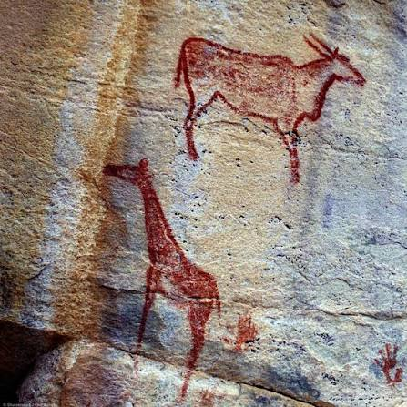
The hills contain thousands of painted and engraved images.

Artists represented:

  • giraffes;

  • eland;

  • antelope;

  • rhinoceros;

  • cattle;

  • humans;

  • and other animals.

The Animal “Zoo”

The diversity of animal imagery is one of Tsodilo's most striking characteristics.

Wild animals could provide information about:

  • hunting;

  • ecology;

  • ritual;

  • and symbolic beliefs.

The presence of animals that are rare or absent in the modern region may also provide clues about past environments.

Hunter-Gatherers

Some of the earliest artistic traditions are associated with hunter-gatherer communities.

These societies relied on:

  • wild game;

  • plants;

  • water;

  • and detailed knowledge of seasonal resources.

Rock art may have formed part of their symbolic and ritual world.

Later Pastoral Communities

Later images include domesticated animals.

Cattle representations demonstrate that the landscape was eventually incorporated into pastoral economies.

This makes Tsodilo valuable for studying economic change.

Engraving Techniques

Artists created engravings by:

  • pecking;

  • scraping;

  • incising;

  • and polishing rock surfaces.

Some images are deeply carved.

Others are faint and difficult to see.

Paint Pigments

Paintings used mineral pigments, especially:

  • red ochre;

  • yellow;

  • white;

  • and black.

Some colors have survived remarkably well because of the dry environment.

Archaeological Occupation

Excavations around the hills have produced:

  • stone tools;

  • pottery;

  • beads;

  • metal objects;

  • and other artifacts.

These materials demonstrate that people repeatedly returned to Tsodilo over thousands of years.

Climate and Landscape

Tsodilo's history is connected to changing environmental conditions.

The surrounding region has experienced fluctuations in:

  • rainfall;

  • vegetation;

  • wildlife;

  • and water availability.

People adapted their subsistence strategies accordingly.

UNESCO World Heritage Status

Tsodilo Hills was designated a UNESCO World Heritage Site because of its exceptional archaeological, cultural, and spiritual importance.

The designation recognizes the hills as one of the most significant cultural landscapes in southern Africa.

Why Tsodilo Matters

Tsodilo is important because it combines:

  • archaeology;

  • rock art;

  • living Indigenous traditions;

  • environmental history;

  • and long-term human occupation.

Conclusion

Tsodilo Hills is far more than a collection of prehistoric paintings.

It is a cultural landscape in which archaeology and living tradition overlap.

Its thousands of animal and human images preserve evidence of changing societies, while the hills themselves remain spiritually significant to local communities.

The result is one of Africa's most extraordinary examples of a landscape that has retained cultural meaning across thousands of years.

Divuyu Satellite Mound: Botswana's Prehistoric Trading Hub

August 23, 2026

Divuyu is an important archaeological site in northern Botswana associated with prehistoric and early historic settlement networks in the broader Okavango and Chobe region.

The description “Satellite Mound” reflects the use of modern remote-sensing and archaeological survey techniques to identify settlement structures and landscape features that can be difficult to recognize from ground level.

The site's importance lies in its potential to illuminate how communities in northern Botswana participated in regional networks of settlement, craft production, exchange, and movement.

Archaeology of Northern Botswana

Northern Botswana contains a rich archaeological record.

The region's rivers and wetlands created corridors through otherwise dry landscapes.

Important waterways include:

  • the Okavango;

  • the Chobe;

  • and associated seasonal channels.

These waterways provided transportation and resources.

Settlement Mounds

Archaeological mounds can develop through repeated occupation.

Layers may contain:

  • pottery;

  • charcoal;

  • animal bones;

  • shell;

  • stone tools;

  • and architectural debris.

Over centuries, these materials accumulate into raised deposits.

Why Mounds Matter

A mound can represent a long history of occupation.

Instead of one short-lived settlement, it may contain multiple phases of human activity.

Archaeologists can excavate these layers to reconstruct changes over time.

Trading Networks

Northern Botswana was connected to wider southern African networks.

Communities could exchange:

  • pottery;

  • metal;

  • beads;

  • stone;

  • animal products;

  • and other resources.

Trade did not necessarily involve professional merchants.

Exchange could occur through networks of neighboring communities.

Iron Age Technology

Ironworking transformed many communities in southern Africa.

Iron tools could improve:

  • agriculture;

  • hunting;

  • woodworking;

  • and construction.

Iron objects could also become valuable exchange items.

Beads and Long-Distance Connections

Glass beads are especially useful for identifying trade.

Imported beads can sometimes be traced to manufacturing traditions from distant regions.

Their presence demonstrates that local communities participated in extensive exchange networks.

The Role of Rivers

Rivers and wetlands were crucial transportation corridors.

They provided:

  • water;

  • fish;

  • reeds;

  • wildlife;

  • and routes through the landscape.

Communities could combine river transport with overland movement.

Remote Sensing

Modern satellite imagery can help researchers identify subtle archaeological mounds.

Researchers can compare:

  • vegetation differences;

  • soil patterns;

  • elevation;

  • and geometric features.

However, satellite detection must be confirmed through fieldwork.

Archaeological Dating

Dating a mound requires multiple lines of evidence.

Researchers may use:

  • radiocarbon dating;

  • ceramics;

  • stratigraphy;

  • metal technology;

  • and imported artifacts.

The phrase “prehistoric” encompasses thousands of years and should not be treated as a precise date.

Why Divuyu Matters

Divuyu contributes to the study of:

  • settlement organization;

  • trade;

  • Iron Age technology;

  • wetland adaptation;

  • and regional interaction.

It demonstrates that northern Botswana was part of a wider network of communities rather than an isolated region.

Conclusion

Divuyu's archaeological landscape illustrates how communities in northern Botswana adapted to waterways and participated in regional exchange.

Modern remote sensing adds a new dimension to the research by allowing archaeologists to identify settlement features that might otherwise remain hidden.

The combination of archaeological excavation and satellite mapping is helping reconstruct a prehistoric landscape in which rivers, villages, craft production, and trade were closely interconnected.

Matobo Hills: Zimbabwe's 2,000-Year Bushman Paintings

August 23, 2026

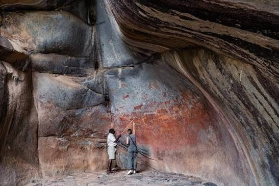
The Matobo Hills in southwestern Zimbabwe form one of Africa's most important prehistoric and historic cultural landscapes.

The region is famous for its dramatic granite formations and extensive collections of rock paintings associated with hunter-gatherer communities, particularly the San and related prehistoric populations.

The paintings include:

  • humans;

  • animals;

  • hunting scenes;

  • ritual figures;

  • and symbolic imagery.

Although some paintings can be approximately 2,000 years old or older, the rock-art tradition of Matobo spans a much broader period.

The Landscape of Matobo

Matobo consists of enormous granite outcrops shaped by erosion.

The rocks form:

  • caves;

  • shelters;

  • balancing formations;

  • cliffs;

  • and natural chambers.

These provided excellent locations for human occupation and rock art.

Why People Used Rock Shelters

Shelters protected people from:

  • sun;

  • wind;

  • rain;

  • and temperature extremes.

They also provided suitable surfaces for painting.

Some shelters contain layers of archaeological occupation beneath their painted walls.

Hunter-Gatherer Communities

Many of the paintings are associated with hunter-gatherer societies.

These communities possessed detailed knowledge of:

  • animal behavior;

  • plants;

  • water sources;

  • seasonal changes;

  • and landscape geography.

Their survival depended on understanding the environment at an extremely sophisticated level.

Animals in the Paintings

Artists represented numerous animals.

These could include:

  • eland;

  • antelope;

  • giraffe;

  • elephant;

  • rhinoceros;

  • and other species.

Animal imagery may reflect both everyday hunting and symbolic beliefs.

The Eland

The eland is particularly important in southern African San rock art.

It appears frequently in ritual contexts.

Ethnographic research among San communities has helped archaeologists understand how animals, especially eland, could be connected to:

  • trance;

  • healing;

  • rainmaking;

  • and spiritual transformation.

However, modern ethnography cannot automatically explain every prehistoric image.

Human Figures

Human figures appear in various forms.

Some may represent:

  • hunters;

  • dancers;

  • ritual specialists;

  • or supernatural beings.

Some images are highly realistic.

Others are abstract or elongated.

Ritual Interpretation

One of the most important interpretations of southern African rock art connects certain scenes to shamanic or trance experiences.

Researchers have proposed that images may represent:

  • altered states of consciousness;

  • healing rituals;

  • supernatural journeys;

  • and interactions with spiritual forces.

These interpretations remain debated but are supported by comparisons with historically documented San traditions.

Pigments

Artists used natural pigments.

Red ochre was especially important.

Other pigments produced:

  • yellow;

  • white;

  • black;

  • and occasionally other shades.

Pigments could be mixed with binding materials before application.

Fingerprints and Techniques

Some prehistoric paintings may have been applied using:

  • fingers;

  • brushes;

  • feathers;

  • or other organic tools.

Because organic tools rarely survive, archaeologists reconstruct techniques from the paintings themselves and experimental archaeology.

Dating the Art

Dating rock paintings is difficult.

Methods include:

  • direct dating of suitable pigment components;

  • radiocarbon analysis;

  • archaeological association;

  • stylistic comparison;

  • and mineral analysis.

Different images within the same shelter may have been created centuries apart.

Later Communities

Matobo was not abandoned after the earliest paintings.

Later communities continued using the landscape.

Archaeological evidence includes:

  • pottery;

  • metal objects;

  • stone tools;

  • and settlement remains.

The hills therefore represent thousands of years of continuous or repeated human interaction.

Sacred Landscape

Matobo also became an important sacred and political landscape in more recent history.

The hills are associated with traditional religious practices and ancestral beliefs.

The landscape later became connected with the history of the Ndebele kingdom and colonial Zimbabwe.

UNESCO World Heritage Site

The Matobo Hills were designated a UNESCO World Heritage Site because of their exceptional combination of:

  • natural scenery;

  • archaeological evidence;

  • rock art;

  • and living cultural traditions.

Why Matobo Matters

Matobo is important because it preserves a remarkable record of human interaction with the landscape across thousands of years.

The paintings reveal:

  • artistic skill;

  • hunting traditions;

  • ritual beliefs;

  • environmental knowledge;

  • and changing cultural practices.

Conclusion

The Matobo Hills are among the greatest repositories of prehistoric rock art in southern Africa.

Their paintings preserve the symbolic world of hunter-gatherer communities who understood animals, landscapes, weather, and spiritual forces through an intricate cultural system.

The hills are therefore not simply an archaeological site.

They are a living cultural landscape where geology, spirituality, history, and prehistoric art remain deeply connected.

Sangla: Baspa's 17th-Century Kinner Kailash Temple

August 21, 2026

The Himalayan Temple Hidden in Baspa Valley: Sangla's Sacred Link to Kinner Kailash

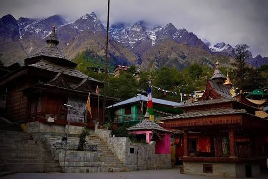
Sangla, located in the Baspa Valley of Kinnaur, is known today for dramatic scenery, traditional villages, and mountain tourism.

But the valley also preserves a deep religious history.

Temples and sacred spaces reflect the interaction of Hindu, Buddhist, and local Himalayan traditions.

Descriptions that assign a single seventeenth-century date to an entire “Kinner Kailash Temple” tradition should be treated carefully, because Himalayan temples often contain multiple construction phases, repairs, and layers of religious history.

The deeper story of Sangla is therefore not about a single building.

It is about an entire sacred landscape.

The Baspa Valley as a Cultural World

The valley provided:

  • Water.

  • Agricultural land.

  • Forest resources.

  • Routes through the mountains.

Settlements developed where these resources could be managed.

Communities built temples and houses using local stone and timber.

Kinnauri Architecture

Traditional architecture in the region is remarkable for its combination of practical engineering and decorative craftsmanship.

Timber and stone could be integrated to produce strong structures.

Wood carving added artistic and religious detail.

Temples became expressions of local identity.

Local Deities and Himalayan Religion

Religious life in Kinnaur cannot be reduced exclusively to either Hinduism or Buddhism.

Local deities and community traditions play important roles.

A village temple may therefore represent layers of belief accumulated over centuries.

Kinner Kailash as Sacred Geography

The presence of Kinner Kailash shapes the spiritual identity of the region.

Sacred mountains create relationships between people and landscape.

Pilgrimage routes, stories, and religious practices transform geography into heritage.

Temple Architecture as Historical Evidence

Studying a temple involves examining:

  • Construction materials.

  • Carving styles.

  • Structural techniques.

  • Renovation phases.

  • Religious imagery.

These features can help historians reconstruct changing cultural influences.

The Seventeenth-Century Himalayan World

The seventeenth century was a period of significant political and religious activity across the Himalayas.

However, assigning a temple entirely to one century can oversimplify its history.

Earlier traditions may survive.

Later communities may rebuild structures.

Therefore, a “seventeenth-century temple” often represents a longer cultural sequence.

Sangla Today

Modern tourism has brought Sangla into wider national and international awareness.

This provides economic opportunities but also creates pressure.

Traditional buildings may be replaced.

Land use can change.

Cultural practices can become commercialized.

Sustainable heritage management is therefore essential.

Why Sangla Matters

Sangla's greatest historical significance lies in its cultural continuity.

The valley is not simply beautiful.

It is inhabited.

Its communities continue to maintain traditions developed through generations of interaction with one of the world's most demanding environments.

The temples, mountains, rivers, and villages form one connected historical landscape.

Medina Azahara: The Lost Palace City of the Caliph Who Wanted to Build Paradise

August 21, 2026

The Lost City Built by a Caliph: Inside Medina Azahara's Spectacular Rise and Sudden Destruction

In the tenth century, near Córdoba, one of the most powerful rulers in the Islamic world ordered the construction of an entirely new palace city.

Its name was Madinat al-Zahra.

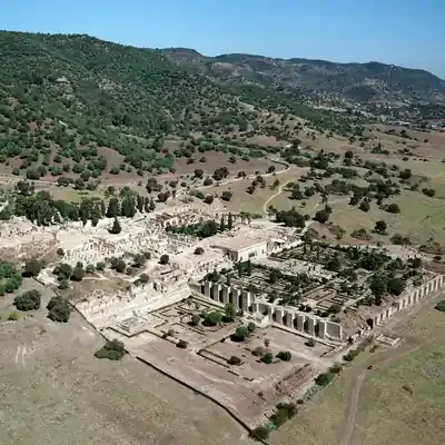
Today, the ruins of Medina Azahara reveal the remains of an ambitious political project designed to demonstrate the power of the Umayyad Caliphate of Córdoba.

The city was more than a residence.

It was a statement.

The Rise of the Caliphate of Córdoba

In 929 CE, Abd al-Rahman III declared himself caliph.

This was a major political act.

A caliph claimed leadership of the Islamic community.

The declaration placed the Umayyad ruler of al-Andalus in direct ideological competition with other major Islamic powers.

Madinat al-Zahra became an architectural expression of this new authority.

Why Build a New City?

A palace could have been expanded within Córdoba.

Instead, a new complex was constructed outside the city.

This allowed the caliph to create a carefully organized environment.

The city included:

  • Palaces.

  • Administrative buildings.

  • Gardens.

  • Reception halls.

  • Residential areas.

  • Infrastructure.

  • Military elements.

Its location and design demonstrated hierarchy.

Architecture as Political Propaganda

Every major empire communicates power.

Some do it through monuments.

Others through ceremonies.

Madinat al-Zahra did both.

Foreign envoys arriving at the palace would encounter controlled sequences of architecture and ceremony.

The physical journey through the complex reinforced the ruler's authority.

The Terraced City

The palace complex was organized across terraces on the hillside.

This created visual hierarchy.

Higher levels were associated with elite and administrative functions.

Architecture shaped movement and visibility.

The landscape itself became part of political design.

The Reception Hall

One of the most spectacular elements of the site is the richly decorated ceremonial architecture associated with royal reception.

Carved stone, arches, decorative panels, and carefully arranged spaces created an environment intended to impress visitors.

Diplomacy became theater.

The visitor did not simply meet the ruler.

The visitor experienced the power of the caliphate.

The Myth of Zahra

Popular tradition sometimes claims that the city was named after a beloved woman named Zahra.

While the story is famous, the historical certainty surrounding such romantic explanations is limited.

The name may instead have broader symbolic or linguistic significance.

This illustrates a common problem in historical interpretation: beautiful stories are not automatically historical facts.

A Short Life

Despite its extraordinary scale, Medina Azahara did not survive for centuries as a functioning capital.

Political instability and civil conflict during the early eleventh century led to its destruction and abandonment.

The great palace city became a ruin.

How an Entire City Was Forgotten

Over time, stone from the abandoned complex could be reused elsewhere.

Sediment covered surviving structures.

The location gradually disappeared from ordinary public memory.

For centuries, the magnificent caliphal city existed largely beneath the landscape.

Archaeology eventually began revealing it again.

Why Medina Azahara Is Extraordinary

The site demonstrates both the power and fragility of political architecture.

A ruler could command enormous resources.

A city could be built to symbolize a new caliphate.

But political collapse could destroy that achievement within a relatively short period.

Today, the ruins reveal a paradox.

The city failed as a permanent political capital.

Yet its archaeological survival allows the modern world to understand the ambitions of one of medieval Europe's most powerful Islamic states.

Alcazaba de Almeria: Almeria's 10th-Century Fortress

August 21, 2026

The 1,000-Year-Old Fortress Above Almería: Inside the Alcazaba Built to Control an Entire Coast

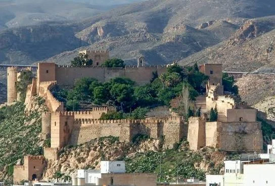
The Alcazaba of Almería dominates the city from its elevated position, reminding visitors that medieval Mediterranean history was shaped as much by fortifications as by palaces.

Built during the Islamic period of al-Andalus and later transformed under Christian rule, the fortress represents centuries of political change.

Its walls do not tell one story.

They preserve layers.

The Foundation of Almería

Almería became an important port and military center during the Umayyad period.

Its location provided access to Mediterranean trade routes.

A major fortress was therefore essential.

The Alcazaba developed as a defensive and administrative complex connected with the growth of the city.

The Meaning of Alcazaba

The word “alcazaba” derives from the Arabic al-qasaba, referring broadly to a fortified urban citadel.

Such structures were not merely military castles.

They could contain:

  • Administrative buildings.

  • Residences.

  • Storage areas.

  • Water systems.

  • Religious spaces.

  • Defensive towers.

The Alcazaba of Almería functioned as the fortified heart of the city.

Walls and Military Engineering

Medieval fortification required careful understanding of terrain.

The builders used elevation to increase defensive advantage.

Walls followed the contours of the landscape.

Towers allowed surveillance.

Gateways controlled access.

Defense was layered.

An attacker might breach one barrier only to encounter another.

Water and Survival

A fortress could not survive a long siege without water.

Therefore, water storage and management were essential.

Cisterns allowed communities to store water.

This was especially important in the dry climate of southeastern Spain.

Islamic Almería and Mediterranean Trade

Almería was not simply a military outpost.

It became an economically important Mediterranean city.

Trade networks connected the region with other parts of the Islamic world and the Mediterranean.

The fortress protected a prosperous urban center.

The Christian Conquest and Architectural Change

When political control changed, the fortress changed with it.

Christian rulers added and modified defensive structures.

This produced a layered monument.

Islamic architecture remained.

Later European military architecture was added.

The result reflects changing technologies of warfare.

Why the Alcazaba Survived

The survival of the complex reflects both its scale and its continued importance.

Because later rulers reused the site, it was not simply abandoned.

Reuse can destroy earlier structures, but it can also preserve them by keeping the location relevant.

A Fortress of Layers

Walking through the Alcazaba is effectively walking through political history.

One section may reflect Islamic rule.

Another may represent later Christian modifications.

The walls preserve the transition.

Why Almería's Alcazaba Matters

The fortress demonstrates that Mediterranean history cannot be reduced to simple narratives of conquest.

Every new ruler inherited an existing landscape.

They reused it.

Modified it.

Adapted it.

The Alcazaba therefore became a physical record of continuity through political change.

Castelo de São Jorge: The Lisbon Citadel Built on Thousands of Years of History

August 21, 2026

Before Portugal, Before Lisbon: The Ancient Secrets Hidden Beneath Castelo de São Jorge

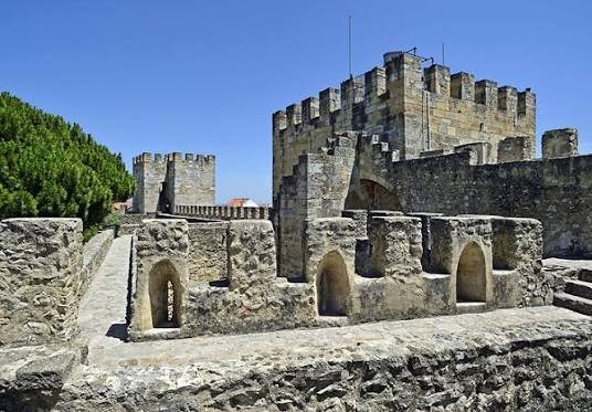
Castelo de São Jorge stands on one of Lisbon's most strategically important hills.

The castle visible today is associated strongly with Portugal's medieval history, but the hill itself contains archaeological layers reaching much further into the past.

Phoenician-related activity, Iron Age communities, Roman occupation, Islamic Lisbon, and Christian Portugal all form part of the wider archaeological story.

The castle is therefore not simply a medieval monument.

It is an archaeological archive.

Why the Hill Was Important

Elevation provides advantages.

From the hill, inhabitants could observe surrounding territory and the Tagus River.

This made the location valuable for defense and settlement.

For thousands of years, communities recognized this strategic importance.

Roman Lisbon

Roman Olisipo developed into an important settlement connected with Atlantic and Mediterranean networks.

The region's relationship with trade, river transport, and imperial administration influenced its growth.

Archaeological remains demonstrate the long urban history beneath the modern city.

Islamic Lisbon

After the Islamic conquest of the Iberian Peninsula, Lisbon became known as al-Ushbuna.

The fortified hill formed an important part of the Islamic city.

Walls and defensive structures protected the settlement.

The later Portuguese castle therefore stands partly within a landscape shaped by Islamic military architecture.

The Christian Conquest

In 1147, Lisbon was captured by forces associated with Portugal's first king, Afonso I, with the assistance of crusading forces.

This event became a defining moment in Portuguese history.

The fortified hill was subsequently incorporated into the political world of the emerging Portuguese kingdom.

Why It Is Called São Jorge

The castle's association with Saint George reflects later Christian traditions.

Saint George was an important military and chivalric symbol in medieval Europe.

The naming demonstrates how monuments can acquire new identities after political change.

Archaeology Beneath the Castle

Modern archaeological investigation has demonstrated that the site contains remains from multiple periods.

This makes excavation especially complex.

Researchers must distinguish between:

  • Ancient occupation.

  • Roman material.

  • Islamic structures.

  • Medieval Portuguese construction.

  • Later modifications.

A wall is not automatically medieval simply because it is located beneath a castle.

Context matters.

Lisbon's Earthquake and the Transformation of the Castle

The devastating earthquake of 1755 transformed Lisbon.

The castle and surrounding city experienced major damage.

Later restoration and reconstruction changed the monument again.

The structure visible today therefore reflects both medieval history and modern conservation.

National Identity and Restoration

During the twentieth century, the castle underwent major restoration.

Such restoration raises important questions.

Should a monument be returned to an imagined medieval appearance?

Or should later historical layers remain visible?

Heritage conservation is often shaped by national identity.

The castle became an important symbol of Portuguese history.

Why São Jorge Matters

The monument tells a much larger story than the history of Portugal alone.

It reveals:

  • Ancient settlement.

  • Roman urban development.

  • Islamic Iberia.

  • Medieval conquest.

  • Portuguese monarchy.

  • Modern nationalism.

  • Archaeological conservation.

Few castles demonstrate so clearly how one location can remain strategically important across thousands of years.

Silves Castle: Algarve's Almohad Fortress

August 21, 2026

Portugal's Red Castle Was Once a Powerful Islamic Capital: The Forgotten Story of Silves

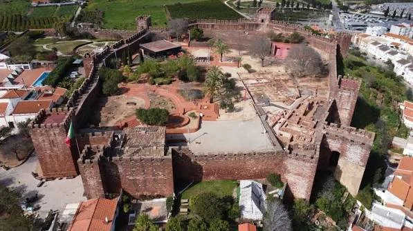
Silves Castle rises above the Algarve as one of Portugal's most impressive surviving fortifications.

Its distinctive reddish stone walls immediately separate it visually from many later European castles.

But Silves was not originally a Portuguese royal fortress.

During the Islamic period, the city—known as Shilb—became one of the most important urban centers in the western Iberian Peninsula.

The castle preserves the memory of this forgotten political and cultural world.

Silves Under Islamic Rule

Following the Islamic conquest of the Iberian Peninsula, the Algarve became integrated into the political and cultural world of al-Andalus.

Silves developed into a major urban center.

Its importance was connected with:

  • Agriculture.

  • River access.

  • Trade.

  • Political administration.

  • Strategic defense.

The castle protected the city.

The Red Sandstone Fortress

One of the most distinctive characteristics of Silves Castle is its use of local red sandstone.

The material gives the fortress its remarkable color.

But the stone was not chosen simply for beauty.

Builders used locally available materials.

The castle's appearance is therefore directly connected to the geology of the region.

Almohad Fortification

The fortress reached an important phase of development during the Almohad period.

The Almohads were a powerful North African and Iberian Islamic dynasty whose political influence extended across large parts of the western Islamic world.

Their period of control was marked by major defensive construction and architectural activity.

The surviving fortress reflects this wider military culture.

Towers, Walls, and Defense

The castle's defensive system included powerful walls and towers designed to control movement.

A medieval fortress depended on multiple defensive principles:

  • Height.

  • Thick walls.

  • Controlled entrances.

  • Towers for observation.

  • Interior storage.

  • Water access.

The design made use of the natural elevation of the site.

Water and the Great Cistern

Perhaps one of the most important features of any fortress is its water supply.

Silves Castle contains a major cistern system.

During a siege, access to water could determine whether a fortified city survived.

Rainwater and other sources had to be collected and stored.

The cistern was therefore not a secondary feature.

It was essential infrastructure.

Silves as a Cultural Center

Islamic cities were centers of more than military power.

Silves developed as an urban and cultural center.

The wider civilization of al-Andalus produced achievements in:

  • Literature.

  • Philosophy.

  • Agriculture.

  • Science.

  • Architecture.

  • Trade.

Silves participated in this broader world.

The Christian Conquest

Silves became a major target during the expansion of Christian kingdoms into southern Iberia.

The city changed hands during periods of conflict before eventually becoming incorporated into the Portuguese kingdom.

Political conquest transformed the fortress.

But, as at many Iberian monuments, new rulers did not erase everything that came before.

They inherited the city.

They reused its walls.

They adapted its structures.

The Archaeological Layers of Silves

The castle and surrounding city contain evidence from multiple historical periods.

Archaeological investigation can reveal:

  • Islamic occupation.

  • Later medieval Portuguese activity.

  • Domestic structures.

  • Defensive modifications.

  • Water infrastructure.

The monument is therefore not a single historical object.

It is a layered landscape.

Why Silves Castle Is So Important

Silves demonstrates the importance of remembering that Portugal's history did not begin with the Portuguese kingdom.

Before the medieval Christian monarchy, the region was part of the Roman world.

Before that, it was occupied by earlier communities.

And for centuries, southern Portugal was part of al-Andalus.

Silves Castle remains one of the most visible reminders of that Islamic past.

Its red walls have survived dynasties, conquests, religious transformations, and political revolutions.

Today, they stand above the Algarve as a reminder of a forgotten capital.

And perhaps that is the castle's greatest secret:

the fortress most visitors see as a Portuguese monument is also one of the most powerful surviving witnesses to Portugal's Islamic history.

Triloknath: Lahaul's Indo-Tibetan Temple

August 21, 2026

One Temple, Two Religions: The 1,000-Year Mystery of Triloknath in the Himalayas

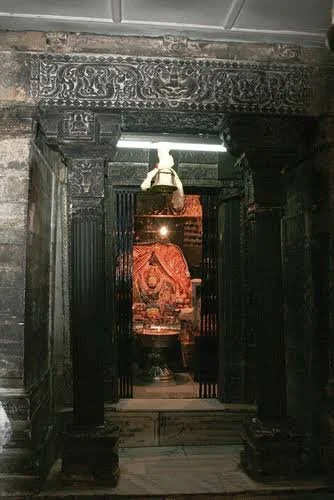
High in the mountainous Lahaul region of Himachal Pradesh stands one of the most remarkable religious monuments in the western Himalayas: Triloknath Temple. The site is extraordinary not simply because of its age or dramatic mountain setting, but because it occupies a cultural space where religious traditions that are often treated separately in modern discussions have historically overlapped.

For Hindu devotees, the temple is associated with Trilokinath, “Lord of the Three Worlds,” a form of Shiva. For Buddhist communities, the sacred image is associated with Avalokiteshvara, the bodhisattva of compassion.

This dual identity makes Triloknath one of the most important examples of religious interaction in the Himalayas.

The temple demonstrates that religious history is often more complicated than neat modern categories suggest. Communities did not always construct rigid boundaries between traditions. Sacred places could be shared, reinterpreted, and understood through multiple religious frameworks.

Lahaul: A Meeting Place Between Cultural Worlds

Lahaul occupies a geographically challenging but historically important region of the western Himalayas. High mountain passes and river valleys connected communities from the Indian subcontinent with Tibetan cultural regions.

For centuries, the region experienced overlapping influences.

These included:

  • Hindu religious traditions.

  • Tibetan Buddhism.

  • Indian Buddhist artistic traditions.

  • Local Himalayan beliefs.

  • Trade networks crossing mountain passes.

  • Political influences from neighboring Himalayan territories.

Triloknath emerged from this complex environment.

Its architecture and religious identity cannot be fully understood by placing it exclusively within either “Hindu” or “Buddhist” history.

The Sacred Image and Its Double Identity

At the center of the temple's religious importance is the principal sacred image.

Different communities interpret the deity according to their own religious traditions.

For Hindu worshippers, the site is associated with Shiva as Trilokinath.

For Buddhist devotees, the central figure is identified with Avalokiteshvara, known in Tibetan traditions as Chenrezig.

This overlap is particularly significant because Avalokiteshvara is one of the most important bodhisattvas in Mahayana Buddhism.

He represents compassion.

In Buddhist belief, the bodhisattva postpones complete entry into final enlightenment in order to assist other beings.

The coexistence of these interpretations demonstrates a long history of cultural adaptation.

The object itself became part of multiple religious worlds.

A Temple Approximately a Millennium Old

Triloknath is generally regarded as an ancient Himalayan religious center with architectural elements and traditions extending back roughly a thousand years, although individual components and later renovations reflect the long life of the monument.

This distinction is important.

Historic temples are rarely frozen in time.

A sanctuary may be founded during one period.

Later communities repair walls.

Images may be replaced or restored.

Roofs can be reconstructed.

New ritual spaces can be added.

Therefore, describing a temple as “1,000 years old” usually refers to the antiquity of its religious and architectural tradition rather than suggesting that every beam and stone has survived unchanged for a millennium.

The Architecture of Cultural Exchange

The architecture of Triloknath reflects the complex cultural environment of the western Himalayas.

Himalayan temples frequently incorporated local building materials and techniques while also reflecting artistic influences from broader regions.

Architectural features could include:

  • Stone construction.

  • Timber structural elements.

  • Carved decorative components.

  • Enclosed sanctuaries.

  • Small courtyards or surrounding religious spaces.

  • Sculptural imagery.

The temple is therefore not merely a place of worship. It is physical evidence of artistic exchange.

Why Religious Boundaries Were Not Always Fixed

Modern observers often imagine that a temple must belong exclusively to one religion.

The historical reality can be very different.

In frontier regions and cultural contact zones, religious communities frequently borrowed ideas, shared sacred landscapes, and adapted preexisting monuments.

A deity could be interpreted differently by different communities.

A sacred mountain could possess importance across multiple traditions.

A pilgrimage route could be used by people with different religious identities.

Triloknath is one of the strongest examples of this phenomenon in the Himalayas.

Pilgrimage and Sacred Geography

The location of Triloknath contributes to its importance.

Pilgrimage involves movement.

The journey itself can become part of religious experience.

Traveling through difficult mountain landscapes reinforces the separation between ordinary life and sacred space.

Historically, reaching a Himalayan temple could require days or weeks of travel.

Pilgrims crossed rivers, valleys, and mountain routes.

The physical effort became intertwined with devotion.

The Importance of Avalokiteshvara

For Buddhist communities, Avalokiteshvara occupies an especially important position.

He is associated with compassion and the desire to assist suffering beings.

The spread of Avalokiteshvara worship across the Himalayan world demonstrates the movement of Buddhist religious traditions between India, Tibet, Nepal, and surrounding regions.

The identification of the sacred image at Triloknath with this bodhisattva places the temple within a much larger Buddhist cultural network.

Shiva and the Three Worlds

The Hindu identification of the site with Trilokinath introduces another layer of meaning.

The name refers to the “Lord of the Three Worlds,” an expression associated with cosmic authority.

Within Hindu traditions, Shiva occupies multiple roles as an ascetic, destroyer, protector, and cosmic figure.

The mountain environment itself is deeply compatible with Shaivite religious symbolism. Shiva is famously associated with Mount Kailash and Himalayan landscapes.

For Hindu pilgrims, therefore, the mountainous setting reinforces the deity's sacred identity.

A Living Monument

Triloknath is not important only because of its historical age.

It remains a living religious site.

This distinction is crucial in heritage studies.

An abandoned ruin can be studied primarily as an archaeological object.

A living temple must be understood through both past and present.

Communities continue to:

  • Visit the site.

  • Worship.

  • Perform rituals.

  • Participate in festivals.

  • Maintain religious traditions.

Conservation must therefore respect both physical heritage and living cultural practice.

Why Triloknath Matters Today

The temple provides an important lesson about the history of religion.

Religious traditions are not always isolated systems separated by impenetrable boundaries.

Human communities interact.

Ideas move.

Images are reinterpreted.

Sacred spaces accumulate new meanings.

For roughly a millennium, Triloknath has stood in one of the world's most challenging landscapes as evidence of this interaction.

It is a temple.

A pilgrimage center.

An architectural monument.

And a reminder that the history of the Himalayas cannot be understood through a single religious story.

Garsha: Himachal Pradesh's 1,000-Year Rock Inscriptions

August 21, 2026

The 1,000-Year-Old Messages Carved Into the Mountains: Inside Garsha's Forgotten Himalayan Inscriptions

Long before printed books, digital archives, or even widespread paper records, people throughout Asia found another way to leave messages for the future.

They carved them into stone.

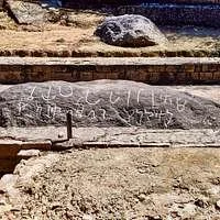
In the Himalayan region historically associated with Garsha, now linked with the wider Lahaul area of Himachal Pradesh, inscriptions, religious markings, and carved symbols provide evidence of the movement of cultures across one of Asia's most difficult landscapes.

A rock inscription may appear simple: a few letters, a religious formula, a name, or a symbol carved into a boulder.

Yet archaeologically, such a mark can reveal extraordinary information.

It can preserve evidence of language.

It can demonstrate the spread of religious traditions.

It can reveal the movement of travelers.

It can indicate political influence.

And sometimes, it can preserve the presence of a person who would otherwise have disappeared completely from history.

Garsha and the Crossroads of the Himalayas

The Lahaul region occupies a strategic position within the western Himalayas.

Historically, its valleys connected regions influenced by Indian, Tibetan, Central Asian, and Himalayan cultures. Movement was difficult, particularly during harsh winters, but mountain passes and river valleys created routes through which goods, ideas, and religious traditions could travel.

The ancient name Garsha appears in historical and Tibetan sources connected with this wider Himalayan world.

The region was not culturally isolated.

Buddhist influence moved through mountain corridors.

Trade brought communities into contact.

Political powers attempted to extend influence across highland territories.

Pilgrims and monks traveled between religious centers.

Rock inscriptions are among the physical traces of these movements.

Why Carve an Inscription Into Stone?

Stone offers permanence.

A message written on cloth can decay.

Wood can rot.

Paper can burn.

But a deeply carved inscription may survive for centuries.

For travelers moving through mountain landscapes, a boulder beside a route could become a public surface.

The inscription could commemorate a religious act.

It could invoke a sacred formula.

It could mark a place.

It could record the name of a donor or official.

It could demonstrate the presence of a particular religious community.

In this sense, ancient Himalayan inscriptions can be understood as a kind of permanent communication system embedded directly into the landscape.

Scripts as Archaeological Evidence

The study of inscriptions involves more than translating words.

Epigraphers examine the physical form of writing.

The shape of individual letters can help determine chronology.

Changes in script occur over time.

Therefore, even when an inscription does not include a date, specialists may compare its writing style with securely dated examples.

Researchers may examine:

  • Letter forms.

  • Direction of writing.

  • Linguistic features.

  • Religious terminology.

  • Surface weathering.

  • Carving technique.

  • Archaeological context.

This makes epigraphy an interdisciplinary science involving history, linguistics, archaeology, and art history.

Buddhism and the Mountain Routes

Buddhist traditions spread across the Himalayas through networks of monasteries, teachers, travelers, and political patrons.

Sacred formulas could be carved into rocks.

Images of religious figures could appear beside inscriptions.

Symbols could transform an ordinary route into a sacred landscape.

A traveler moving through a valley might encounter repeated religious signs. The environment itself became a kind of spiritual map.

This practice was especially important in regions where large permanent monuments were difficult to construct.

A boulder was already present.

All that was required was the labor and skill to transform its surface.

Who Made the Inscriptions?

One of the most fascinating questions is also one of the hardest to answer.

The person who carved an inscription may have been:

  • A monk.

  • A local patron.

  • A traveler.

  • A merchant.

  • A political official.

  • A pilgrim.

  • A skilled artisan.

  • A member of a religious community.

Sometimes inscriptions preserve names.

In other cases, the author remains anonymous.

But anonymity does not reduce their historical importance.

The carved mark still records human presence.

The Technology of Carving

Creating an inscription required tools.

Depending on the stone and period, artisans could use metal implements or other suitable instruments to produce incised lines.

The work required precision.

A poorly placed strike could damage a letter.

Complex scripts demanded familiarity with written forms.

Therefore, inscriptions represent both literacy and craftsmanship.

The Environment as an Archive

Mountain environments can preserve inscriptions for long periods, but they also threaten them.

Wind can erode surfaces.

Water can cause cracking.

Freeze-thaw cycles can damage stone.

Modern construction can destroy archaeological contexts.

Vandalism and unregulated tourism can also pose serious dangers.

An inscription that survived a thousand years can be damaged in minutes.

This makes documentation critically important.

Photography, digital scanning, and three-dimensional recording allow researchers to preserve information even when physical surfaces begin to deteriorate.

Why the Inscriptions Matter

Garsha's carved rocks remind us that ancient history was not limited to royal capitals.

Important cultural exchange occurred in valleys, passes, and remote landscapes.

A mountain route could connect civilizations.

A simple inscription could preserve evidence of that connection.

Today, these carvings remain silent.

But they were once messages.

Someone deliberately stood before a stone and decided that an idea, a name, or a sacred phrase was important enough to leave behind.

A thousand years later, that decision still speaks.

Namgyal Gompa: Mustang's Cliffside Hermitage

August 21, 2026

Hidden in the Cliffs of Mustang: The Ancient Himalayan Hermitage That Seems to Defy the Mountains

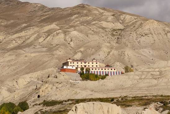
High in the dramatic landscapes of Mustang, Nepal, where deep valleys cut through the rain-shadow of the Himalayas and ancient trade routes once connected Tibet with the Indian subcontinent, Buddhist monasteries, meditation sites, and cliffside religious structures preserve evidence of centuries of Himalayan spiritual life. Among the names associated with this extraordinary cultural landscape is Namgyal Gompa, a site whose identity as a remote Buddhist hermitage reflects one of the most enduring traditions of the Tibetan cultural world: the deliberate search for isolation.

Unlike monumental palaces or vast urban temples, a Himalayan hermitage represents a different kind of architecture. Its importance does not necessarily depend on size. Instead, its significance lies in location, religious function, landscape, and the relationship between human beings and an environment that appears almost impossible to inhabit. A structure built near a cliff, cave, or remote mountain valley was often intended to separate religious practitioners from ordinary social life and bring them closer to the spiritual ideals of meditation, discipline, and contemplation.

The story of Namgyal Gompa must therefore be understood within the much larger history of Mustang. This region was never merely an isolated corner of the Himalayas. For centuries, Mustang stood at the intersection of cultures, trade routes, political powers, and religious traditions. Its settlements, caves, monasteries, fortifications, and painted temples preserve a remarkable record of the interaction between the Tibetan Plateau and the Himalayan world.

Mustang: A Himalayan Landscape Shaped by Isolation and Connection

Modern maps can make Mustang appear remote, but remoteness did not mean historical insignificance. The Kali Gandaki Valley formed one of the major corridors linking regions north and south of the Himalayas. Traders, pilgrims, herders, monks, political envoys, and travelers moved through these mountain routes for centuries.

This movement brought cultural influences into Mustang from Tibet and other Himalayan regions. Buddhism became deeply rooted in local society, while Tibetan languages, artistic traditions, religious institutions, and architectural styles shaped the cultural identity of the region.

At the same time, Mustang developed its own political history. The Kingdom of Lo, centered historically around Lo Manthang, emerged as an important Himalayan kingdom. Its fortified settlements, monasteries, and religious monuments demonstrate that Mustang was both a frontier and a cultural center.

A hermitage such as Namgyal Gompa must be viewed against this background. Even the most isolated monastery was connected to a wider network of communities, religious lineages, pilgrimage routes, and systems of patronage.

Why Build a Monastery on a Cliff?

The dramatic placement of Himalayan religious sites was not simply an architectural challenge. Mountains and cliffs possessed profound symbolic importance in Tibetan and Himalayan religious traditions.

The mountains could be understood as sacred landscapes.

Caves could become places of meditation.

Remote valleys could be associated with saints, teachers, or hidden spiritual realms.

Isolation itself could become a religious tool.

A monk living in a remote hermitage was physically separated from many of the distractions associated with ordinary life. The difficult journey required to reach such a location could reinforce the site's spiritual importance. The landscape itself became part of religious practice.

This is why cliffside monasteries and cave complexes appear repeatedly throughout the Himalayan world.

The architecture did not dominate the mountain.

It adapted to it.

Walls followed irregular rock surfaces. Small structures occupied narrow terraces. Prayer spaces were built where geography allowed. Natural caves could be transformed into meditation chambers or shrines.

The Buddhist Tradition of Retreat

In Tibetan Buddhism, religious life has never been limited to large monasteries filled with hundreds of monks. Alongside institutional monasticism existed traditions of solitary and semi-solitary retreat.

A practitioner might withdraw for an extended period to meditate.

This could involve:

  • Living in a cave.

  • Occupying a small hermitage.

  • Practicing under the guidance of a religious teacher.

  • Performing rituals and recitations.

  • Studying sacred texts.

  • Engaging in intensive meditation.

The physical environment of a cliffside hermitage could therefore serve a practical and symbolic purpose. It created distance from ordinary settlements while placing the practitioner within a landscape considered spiritually powerful.

Architecture in an Extreme Environment

Constructing religious buildings in Mustang required adaptation to climate and available materials.

Traditional structures frequently relied on combinations of:

  • Stone.

  • Mud mortar.

  • Timber.

  • Earth.

  • Whitewashed walls.

  • Flat roofs.

  • Small windows designed to reduce exposure to harsh conditions.

In more protected locations, builders could develop larger complexes. On narrow or elevated sites, architecture had to respond directly to the available terrain.

This produced one of the most visually striking characteristics of Himalayan architecture: buildings often appear to grow directly from the landscape.

At Namgyal Gompa, the idea of a cliffside hermitage reflects this broader tradition of architecture shaped by geography rather than imposed upon it.

Mustang and the World of Cave Dwellings

Mustang is internationally famous for its ancient cliff caves.

Thousands of human-made cavities have been identified in different parts of the region. Some were used for burial, storage, habitation, or religious activity. Others remain difficult to interpret.

These caves demonstrate that humans had been adapting to Mustang's cliffs for centuries, and in some areas for much longer periods.

The later development of Buddhist monasteries and hermitages therefore occurred within a landscape where cliffs had already been transformed by human activity.

The mountain was not empty.

It was part of history.

Art, Religion, and the Tibetan Cultural World

A Himalayan monastery was rarely just a building.

Its interior could contain:

  • Buddhist statues.

  • Painted murals.

  • Thangka paintings.

  • Religious manuscripts.

  • Images of Buddhas and bodhisattvas.

  • Protective deities.

  • Ritual objects.

  • Prayer flags and symbolic decorations.

The artistic traditions found throughout Mustang reveal connections with wider Tibetan Buddhist cultures. At the same time, local artists and communities adapted these traditions according to available resources and regional practices.

This combination of local identity and trans-Himalayan influence is one of the defining characteristics of Mustang's religious heritage.

The Challenge of Preservation

Remote religious sites face unique preservation problems.

Earth construction can be vulnerable to water damage.

Timber can deteriorate.

Earthquakes can threaten centuries-old structures.

Climate change can alter rainfall patterns.

Modern development can introduce new pressures.

In addition, the increasing accessibility of Mustang has created a paradox. Tourism can bring attention and resources to heritage sites, but it can also create physical and cultural pressures.

Preservation therefore requires a balance between access and protection.

Why Namgyal Gompa Matters

The importance of a site like Namgyal Gompa cannot be measured only through monumental scale or famous artifacts.

Its significance lies in what it represents.

It represents the religious geography of Mustang.

It represents the Himalayan tradition of retreat.

It represents the ability of communities to construct sacred spaces in extreme landscapes.

And it demonstrates a fundamental principle of human history: people do not simply inhabit landscapes. They give landscapes meaning.

A cliff becomes a place of meditation.

A cave becomes a shrine.

A remote mountain becomes a sacred destination.

Namgyal Gompa stands within this ancient relationship between geography, religion, and human imagination.

For centuries, the cliffs of Mustang have appeared almost untouched by civilization. Yet closer examination reveals something very different.

The mountains are filled with history.

And hidden among them are places where generations of people sought not wealth, conquest, or political power—but silence, discipline, and spiritual transformation.

Pontnewydd Cave: Wales' Neanderthal Teeth

August 18, 2026

Pontnewydd Cave is one of the most important prehistoric sites in Wales and one of Britain's key locations for understanding ancient human occupation during the Middle Pleistocene.

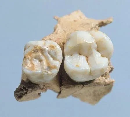
The cave has produced stone tools, animal remains, and fossil human material, including teeth.

These discoveries provide evidence for archaic human populations connected with the Neanderthal evolutionary lineage.

The significance of the site is enormous.

It demonstrates that ancient humans occupied parts of what is now Wales hundreds of thousands of years before Homo sapiens entered Europe.

A World Before Modern Humans

The occupants of Pontnewydd did not belong to our own species.

They lived during the Middle Pleistocene, a period characterized by repeated climatic changes.

Glacial and warmer interglacial periods transformed the landscape.

Human populations could occupy Britain during favorable conditions and disappear during colder periods.

The archaeological record is therefore discontinuous.

Pontnewydd preserves evidence from one of these ancient episodes.

The Importance of Human Teeth

Teeth are among the most durable parts of the skeleton.

They can survive when much of the rest of the body disappears.

Their shape can provide evidence for evolutionary relationships.

Researchers examine:

  • Crown shape

  • Root structure

  • Enamel thickness

  • Wear

  • Development

  • Morphological features

At Pontnewydd, the fossil remains provide important evidence for identifying the nature of the human population present at the site.

Neanderthals and Their Ancestors

The term “Neanderthal” can be used broadly in popular writing, but Middle Pleistocene fossils may represent populations ancestral to or closely related to later classic Neanderthals.

Human evolution was not a simple ladder.

Populations changed over time.

Groups migrated.

Some became isolated.

Others mixed.

Pontnewydd belongs to this complex evolutionary history.

Stone Tools and Ancient Technology

The ancient inhabitants were skilled toolmakers.

Stone tools could be used for:

  • Butchering animals

  • Cutting plant material

  • Processing hides

  • Working wood

  • Manufacturing additional tools

The production of a stone tool required knowledge of raw materials and controlled force.

The maker needed to understand how a stone would fracture.

This technological knowledge was passed through generations.

The Ancient Welsh Landscape

The Wales encountered by these humans was radically different from the modern country.

The climate shifted repeatedly.

Animal populations changed.

Large mammals moved through the region.

Human survival depended on understanding this environment.

The cave was likely only one location within a larger territory.

People hunted and traveled outside it.

They entered the cave temporarily.

The archaeological deposits preserve fragments of these movements.

Animal Remains and the Environment

Animal fossils help archaeologists reconstruct ancient ecosystems.

Different species indicate different environmental conditions.

The bones may also preserve evidence of:

  • Human cut marks

  • Carnivore damage

  • Weathering

  • Burning

  • Breakage

By combining animal evidence with stone tools and human fossils, researchers can reconstruct the broader world in which the Pontnewydd people lived.

Britain Was Connected to Europe

During periods of lower sea level, Britain was not always separated from continental Europe.

Land connections allowed humans and animals to move between regions.

The ancient inhabitants of Pontnewydd were therefore part of a much larger European population.

Modern political geography has no relevance to their world.

There was no Wales.

No England.

No English Channel in its present form.

There was simply a changing prehistoric landscape.

Why Pontnewydd Matters

Human fossils are rare.

A single tooth can transform scientific understanding.

The discoveries from Pontnewydd demonstrate that archaic human populations reached western Britain during the Middle Pleistocene.

This challenges the idea that prehistoric Britain existed on the edge of human history.

It was part of it.

Pontnewydd preserves evidence of humans who lived hundreds of thousands of years before modern civilization and hundreds of thousands of years before modern humans themselves arrived.

Cathole Cave: Wales' Mesolithic Engravings

August 18, 2026

Cathole Cave on the Gower Peninsula is part of a prehistoric landscape that has produced evidence of human activity extending across immense periods of time.

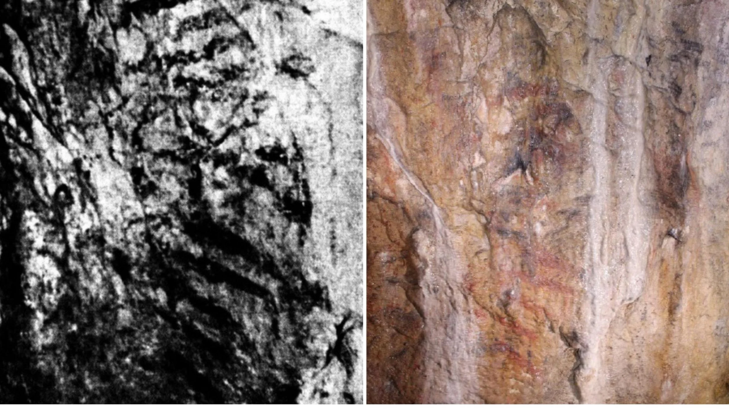
The cave has attracted particular interest because of marks and engravings that have been investigated as possible examples of prehistoric artistic or symbolic expression.

But cave art is notoriously difficult to identify.

A line carved into stone may be ancient.

It may be recent.

It may even be natural.

For this reason, the study of Cathole Cave requires caution.

The mystery is not simply what the engravings mean.

The first question is whether every mark identified as potentially prehistoric can be securely assigned to a particular period.

The Archaeological Landscape of Gower

The Gower Peninsula contains several important prehistoric caves.

Paviland and Goat's Hole demonstrate that the region was visited by Upper Paleolithic humans tens of thousands of years ago.

Other caves and sites provide evidence for later prehistoric activity.

Cathole Cave therefore belongs to a wider landscape repeatedly used by different human populations.

How Can Archaeologists Identify Cave Art?

Researchers do not simply look at a mark and decide that it is ancient.

They examine:

  • Groove shape

  • Tool marks

  • Surface weathering

  • Mineral deposits

  • Superimposition

  • Microscopic characteristics

  • Archaeological context

  • Comparisons with other known examples

Scientific methods can help distinguish deliberate engravings from natural scratches or recent damage.

However, direct dating remains difficult.

The Problem of Dating

A stone engraving does not contain organic material that can automatically be radiocarbon dated.

Researchers may instead date associated deposits.

They may examine mineral layers that formed before or after the engraving.

They may compare the style and technique with securely dated examples elsewhere.

This means that claims about prehistoric cave art often involve degrees of confidence rather than absolute certainty.

Art Beyond Pictures

Modern people often expect prehistoric art to depict recognizable animals.

But symbolic expression can take many forms.

A deliberate series of lines may have represented:

  • A geometric pattern

  • A symbol

  • A counting system

  • A personal mark

  • A ritual design

  • Something that no modern observer can understand

The inability to recognize a symbol does not mean that it was meaningless.

The Mesolithic Question

If engravings or activity at Cathole Cave are associated with Mesolithic hunter-gatherers, they belong to a period of dramatic environmental transformation.

The Ice Age was ending.

Forests expanded.

Sea levels rose.

Human communities adapted.

Mesolithic people continued to create meaningful objects and interact with landscapes in culturally significant ways.

However, claims about exact dating should always reflect the strength of the available archaeological evidence.

Caves as Cultural Places

A cave is not necessarily important only because it provides shelter.

Caves can become:

  • Landmarks

  • Meeting places

  • Ritual locations

  • Places associated with memory

  • Locations for artistic activity

  • Burial sites

The repeated use of caves across prehistoric Wales suggests that they formed part of cultural landscapes.

People remembered them.

They returned.

They may have attached stories or meanings to them.

Why a Single Engraving Can Matter

A small carving can demonstrate that prehistoric humans were doing more than meeting immediate physical needs.

Creating a mark requires intention.

It may represent communication.

It may preserve memory.

It may transform a natural surface into a cultural object.

This is why potential prehistoric engravings receive serious archaeological attention.

The Limits of Interpretation

Even when archaeologists establish that a mark is ancient and deliberate, its meaning may remain impossible to recover.

The original artist did not leave a written explanation.

Their language is lost.

Their cultural system may have disappeared completely.

Archaeology can preserve action without preserving intention.

This is one of the central challenges of prehistoric research.

The Lasting Mystery of Cathole Cave

Cathole Cave represents the power and limitation of archaeology.

Scientists can examine the rock.

They can analyze microscopic grooves.

They can study associated artifacts and sediments.

They can compare the marks with other prehistoric traditions.

Yet the final meaning may remain hidden.

Perhaps that is why prehistoric cave art is so compelling.

A human hand may have touched the stone thousands of years ago.

That person made a mark for a reason.

The cave preserved the physical evidence.

But the reason itself may have vanished.

And in that silence, Cathole Cave continues to ask the same question of every visitor:

What did the person who made this mark want the future to remember?

Goat's Hole Cave: Wales' Cro-Magnon Skull

August 18, 2026

Goat's Hole Cave on the Gower Peninsula is one of the most famous archaeological locations in Britain.

It is best known as the place where the Red Lady of Paviland was discovered.

However, describing the site simply as the location of a “Cro-Magnon skull” is misleading.

The archaeological story is much larger.

Goat's Hole preserves evidence connected with early modern human activity, symbolic behavior, Ice Age landscapes, and one of the most famous prehistoric burials ever discovered in Britain.

The Meaning of “Cro-Magnon”

The term “Cro-Magnon” was once widely used to describe early modern humans in Europe.

Modern archaeology and anthropology generally prefer terms such as:

  • Early modern humans

  • Anatomically modern humans

  • Upper Paleolithic Homo sapiens

The older label can create the mistaken impression that “Cro-Magnons” were a separate human species.

They were not.

They were members of Homo sapiens.

The Famous Burial

The Red Lady discovery transformed Goat's Hole into one of Britain's most important archaeological sites.

The individual was originally believed to be female.

Modern scientific analysis demonstrated that the skeleton belonged to a young adult male.

The remains were associated with red ochre and decorative materials.

This indicates deliberate treatment.

The burial was not simply an accidental death followed by natural deposition.

Human action was involved.

A Cave of Symbolic Behavior

The use of pigment and ornaments suggests that the people associated with the burial engaged in symbolic behavior.

Objects can communicate identity.

Colors can carry meaning.

The treatment of the dead can express social relationships.

However, the precise beliefs remain unknown.

Archaeologists must distinguish between evidence and interpretation.

We can identify deliberate behavior.

We cannot reconstruct the complete worldview behind it.

Ice Age Britain

When the individual was buried, Britain formed part of a larger Ice Age landscape.

Sea levels differed dramatically from today.

Connections with continental Europe changed over time.

Hunter-gatherers moved through landscapes according to available resources and environmental conditions.

Goat's Hole was part of this world.

The Archaeological Importance of the Cave

The cave contributes evidence to several major research questions:

  • When did modern humans occupy Britain?

  • How did Upper Paleolithic communities treat their dead?

  • How important was symbolic behavior?

  • How did humans adapt to changing Ice Age environments?

  • What relationships existed between Britain and continental Europe?

The site therefore has importance far beyond one famous skeleton.

The History of the Discovery

The excavation history also matters.

The Red Lady was discovered during the early nineteenth century, before modern archaeology developed its present methods.

Contextual information was therefore not recorded with the precision expected today.

This created challenges for later researchers.

Modern archaeology has had to reconstruct the site's history using surviving evidence, documentation, comparative analysis, and scientific dating.

Why Goat's Hole Still Matters

The cave preserves one of the clearest examples of how archaeology can change our understanding of human antiquity.

A skeleton once interpreted as relatively recent was eventually recognized as belonging to an Ice Age individual.

The change was revolutionary.

It helped demonstrate that human history extended far beyond traditional written chronologies.

Goat's Hole therefore stands at the intersection of two histories.

It preserves the history of an Upper Paleolithic human being.

And it preserves the history of modern science learning how ancient humanity really is.

Long Hole Cave: Wales' Paleolithic Hearths

August 18, 2026

Long Hole Cave is one of the important prehistoric cave sites of Wales and forms part of the rich archaeological landscape of the Gower Peninsula. Like several other caves in this region, Long Hole preserves evidence of human activity dating back to the Paleolithic, or Old Stone Age. Among the most significant forms of evidence associated with prehistoric occupation are traces of fire, including hearths and burnt materials.

Although a hearth may appear to be a simple archaeological feature, evidence of controlled fire can reveal a remarkable amount about prehistoric life. Fire provided warmth, light, protection, and a means of preparing food. It could also create a social center around which people gathered, worked, rested, and interacted.

The evidence from sites such as Long Hole Cave therefore contributes to a broader understanding of how prehistoric communities occupied caves and adapted to the changing environments of Ice Age Britain.

The Archaeological Importance of Long Hole Cave

The caves of the Gower Peninsula have long attracted archaeological attention because they preserve evidence from different periods of prehistory. Their limestone formations created protected spaces where sediments, bones, stone tools, and other traces of human activity could survive.

Long Hole Cave is part of this wider archaeological landscape. Rather than being understood in isolation, it is useful to view the cave alongside other prehistoric sites in Wales that document the long relationship between humans and the region.

During the Paleolithic, Britain was repeatedly affected by major climatic changes. At certain times, human populations could enter the region from continental Europe, while at other times colder conditions or changing geography made occupation more difficult.

As a result, evidence of prehistoric activity in British caves often represents episodes of occupation separated by long periods.

What Is a Prehistoric Hearth?

A hearth is an area where fire was deliberately created and controlled. In archaeological contexts, the original flames have long disappeared, but their physical traces may remain.

Archaeologists can identify possible hearths through evidence such as:

  • concentrations of charcoal,

  • ash deposits,

  • reddened or heat-altered sediments,

  • burnt stone,

  • burnt animal bone,

  • and patterns showing that materials were repeatedly exposed to high temperatures.

The interpretation of ancient fire features requires careful analysis. Not every burnt area necessarily represents a deliberately constructed hearth. Natural fires, disturbed sediments, and later activity can complicate the archaeological record.

For this reason, researchers examine the location, composition, and surrounding context of possible fire features before determining how they were created.

Why Fire Was Essential to Paleolithic Life

For Paleolithic communities, fire was one of the most important technologies available.

In the cold environments associated with parts of the Ice Age, fire provided warmth and could make caves or sheltered locations more comfortable for occupation.

It also provided light.

Without artificial lighting, the deeper sections of caves would have been completely dark. Fire therefore extended the range of activities that could take place in sheltered environments.

Fire also allowed people to cook food. Cooking could make meat easier to chew and digest and may have helped reduce some biological risks associated with consuming raw food.

Other possible uses of fire included:

  • processing animal materials,

  • hardening or modifying wooden objects,

  • providing protection from some predators,

  • producing smoke,

  • and creating a gathering place for social interaction.

The control of fire was therefore not simply a matter of survival. It influenced the organization of prehistoric daily life.

Hearths as Centers of Social Life

A hearth can reveal more than technological skill.

Fire naturally creates a focal point.

People may gather around it to eat, repair tools, process animal remains, prepare materials, or share information.

For prehistoric communities without permanent houses, a repeatedly used fire location could help organize the temporary living space.

Archaeologists sometimes examine the distribution of artifacts around hearths to understand activity areas. For example, concentrations of stone flakes may indicate tool production, while animal bones may reveal food processing.

Although the exact social activities that occurred around the Paleolithic hearths of Long Hole Cave cannot be directly observed, the presence of controlled fire provides evidence of organized occupation.

Life in Paleolithic Wales

The people who used caves in prehistoric Wales lived in environments very different from those seen today.

During colder periods of the Pleistocene, large parts of northwestern Europe experienced conditions associated with the Ice Age.

Depending on the particular period, the landscape could support animals such as:

  • reindeer,

  • horses,

  • mammoths,

  • bison,

  • deer,

  • and large predators.

Human populations living in these environments depended on detailed knowledge of their surroundings.

They needed to understand:

  • where animals moved,

  • which areas provided useful stone,

  • where shelter was available,

  • how seasons affected resources,

  • and how changing weather influenced survival.

Caves such as Long Hole could provide temporary shelter within this broader landscape.

Stone Tools and Fire

Paleolithic sites are often identified through stone tools and the debris created during their production.

A prehistoric toolmaker could strike a prepared stone core to remove sharp flakes. These flakes could then be used directly or modified into specialized tools.

Stone implements were important for:

  • cutting meat,

  • processing hides,

  • working wood,

  • and preparing other materials.

The association of stone tools with hearth areas can help archaeologists reconstruct activity zones.

A group may have gathered around a fire while repairing or producing tools. Alternatively, tools may have been used to butcher animals before meat was cooked nearby.

Every artifact gains additional meaning when studied within its archaeological context.

Animal Bones and Evidence of Food Preparation

Animal remains found in prehistoric caves can provide important clues about human behavior.

Bones may reveal which animals were available in the surrounding environment. Some bones may also preserve marks associated with butchery or exposure to heat.

Cut marks can indicate the removal of meat or the processing of carcasses.

Burning may suggest that bones were exposed to fire, although archaeologists must determine whether this occurred during cooking, disposal, or later natural processes.

The combination of hearth evidence and animal remains can therefore provide a picture of prehistoric subsistence.

The Challenge of Preserving Hearths

Ancient hearths are fragile archaeological features.

Over thousands of years, sediments can be disturbed by:

  • water,

  • animals,

  • erosion,

  • later human activity,

  • excavation,

  • and geological processes.

Ash may be washed away or chemically altered.

Charcoal may decay.

A hearth that was once clearly visible may survive only as a faint discoloration in the sediment.

This makes careful excavation essential.

Modern archaeologists document the exact location and depth of materials and increasingly use microscopic and chemical methods to identify traces of burning that may not be visible to the naked eye.

Long Hole Cave and the Archaeology of the Gower Peninsula

Long Hole is part of a broader prehistoric landscape that includes several important caves and rock shelters.

The Gower Peninsula has preserved evidence from different stages of human prehistory, including periods associated with Paleolithic hunter-gatherers and later communities.

When studied together, these sites allow archaeologists to investigate broader questions.

These include:

  • When did humans occupy Wales?

  • How did Ice Age climate affect settlement?

  • Which animals were hunted?

  • How were caves used?

  • How did prehistoric populations organize temporary living spaces?

A single cave may provide only part of the answer, but a network of archaeological sites can reveal patterns across an entire region.

Why Paleolithic Hearths Matter

The discovery of an ancient hearth provides evidence of something fundamental to human history: the ability to create and maintain a controlled environment.

A fire transforms a dark, cold space.

It provides warmth and light and creates a place where people can gather.

For prehistoric communities, this technological ability helped make challenging environments more habitable.

The hearths associated with Long Hole Cave therefore represent more than traces of ancient burning.

They are evidence of planning, adaptation, and daily life.

Conclusion

Long Hole Cave offers an important glimpse into prehistoric occupation in Wales. Evidence associated with Paleolithic hearths helps archaeologists understand how early human communities used fire within sheltered environments.

These traces connect modern researchers with moments of everyday life that occurred thousands of years ago: fires being maintained, food being prepared, tools being repaired, and groups gathering for warmth and protection.

Although the archaeological record is incomplete and many details of the people who occupied Long Hole remain unknown, the evidence of controlled fire remains a powerful reminder of the technological and social importance of the hearth in human history.

Cueva de Nerja: Spain's 42,000-Year Cave Paintings

August 18, 2026

Cueva de Nerja, or Nerja Cave, is one of the most important prehistoric sites in southern Spain. Located near the town of Nerja in Andalusia, the vast cave system contains impressive geological formations as well as evidence of human activity extending across different periods of prehistory.

The cave is particularly significant because of the presence of prehistoric paintings and other archaeological remains. Some discussions of its earliest artistic evidence have proposed extremely ancient dates, including possible ages approaching 42,000 years. However, the chronology of some of the oldest images has been the subject of scientific debate and continuing research.

For this reason, Cueva de Nerja is important not only as a site of prehistoric art but also as an example of the challenges involved in dating ancient cave paintings.

The Discovery of Cueva de Nerja

The modern discovery of Nerja Cave occurred in 1959 when local young people entered sections of the cave system that had not previously been known to the public.

The discovery quickly attracted scientific attention.

The cave contained enormous chambers, spectacular stalactites and stalagmites, and evidence that humans had visited and used parts of the system during prehistoric times.

Subsequent archaeological research revealed a long sequence of occupation and activity.

The cave became an important site for studying the prehistoric populations of southern Iberia.

The Cave as a Prehistoric Landscape

Cueva de Nerja is not simply a single chamber containing paintings.

It is an extensive underground system with different spaces that could have been used in different ways.

The deeper parts of caves often differ dramatically from the entrance areas.

Near the entrance, natural light may have allowed ordinary activities to take place.

Further inside, darkness would have required artificial illumination.

The decision to travel into these darker areas may therefore have had practical, symbolic, or cultural significance.

The Prehistoric Paintings

The cave contains painted and engraved images created by prehistoric populations.

The subjects and marks found in cave art can include:

  • animals,

  • abstract symbols,

  • lines,

  • dots,

  • geometric forms,

  • and other deliberate images.

In the case of Nerja Cave, some of the most discussed images have been associated with seal-like forms.

These paintings became internationally famous when scientific investigations raised the possibility that they could be extremely ancient.

The Debate Over the 42,000-Year Date

One of the most fascinating aspects of Cueva de Nerja concerns attempts to determine the age of some of its paintings.

Dating cave art is difficult.

A painting may contain pigments that cannot easily be dated directly. If the image was made with mineral pigments such as iron oxide, standard radiocarbon dating may not be possible because the pigment itself contains no organic carbon.

Researchers may therefore attempt to date materials associated with the image, such as mineral formations that developed over or beneath the artwork.

This process can provide a minimum or maximum age, depending on the relationship between the formation and the painting.

Some results associated with the paintings of Nerja have produced very early dates, leading to discussion about whether some images might have been created tens of thousands of years ago.

However, an early date obtained from associated material does not automatically provide a precise direct date for the painting itself.

For this reason, interpretations of the oldest art at Nerja require caution.

Could Neanderthals Have Created Some of the Art?

If some cave images in Europe were created before or during the earliest arrival of modern humans in a particular region, this raises an important question:

Could Neanderthals have created symbolic art?

For many years, symbolic behavior was considered primarily a characteristic of Homo sapiens.

However, archaeological discoveries have increasingly challenged this simple distinction.

Evidence from Europe has shown that Neanderthals were capable of complex behavior involving:

  • pigments,

  • personal ornaments,

  • deliberate markings,

  • and other possible forms of symbolic expression.

The possibility of very ancient paintings at Nerja therefore contributed to broader debates about Neanderthal creativity.

Nevertheless, determining the exact creator of a specific painting requires strong chronological evidence.

The relationship between Neanderthals, modern humans, and early European cave art remains an active field of archaeological research.

Pigments Used in Cave Art

Prehistoric artists used materials obtained from the natural environment.

Common pigments included:

  • red ochre, containing iron oxides,

  • yellow and brown mineral pigments,

  • manganese-based black pigments,

  • charcoal,

  • and other naturally occurring substances.

The pigment could be applied in different ways.

Artists might:

  • use fingers,

  • apply pigment with a simple brush,

  • rub pigment onto the rock,

  • use pads or other tools,

  • or blow powdered pigment through the mouth or a tube.

Each method could create a different visual effect.

Why Did Prehistoric People Paint Caves?

The exact purpose of prehistoric cave art remains uncertain.

Archaeologists have proposed many interpretations.

These include:

  • ritual activity,

  • communication,

  • storytelling,

  • territorial identity,

  • teaching,

  • spiritual beliefs,

  • social memory,

  • or artistic expression.

No single explanation can necessarily account for every image at every site.

Cave art developed across different cultures and thousands of years.

Its meaning may have changed over time.

A painting created in one period could have had a completely different purpose from an image created thousands of years later.

Cueva de Nerja and the Upper Paleolithic

The Upper Paleolithic was a period of major cultural development in Europe.

During this era, modern human populations developed increasingly diverse forms of:

  • stone technology,

  • bone and antler craftsmanship,

  • personal ornaments,

  • figurative art,

  • and symbolic communication.

Iberia became one of the major regions for the preservation of prehistoric cave art.

The mountains and limestone landscapes of Spain contain numerous caves with archaeological evidence from different periods.

Nerja is part of this much larger cultural landscape.

Human Occupation Beyond Cave Art

The importance of Cueva de Nerja extends beyond its paintings.

Archaeological deposits provide evidence about the people who used the cave over time.

Such evidence can include:

  • stone tools,

  • animal bones,

  • shells,

  • charcoal,

  • pottery from later periods,

  • and other materials.

These remains help researchers reconstruct changes in human activity.

A cave may be used differently from one generation to another.

One period may involve temporary shelter, while another may involve ritual activity or storage.

Climate and Prehistoric Southern Spain

The location of Nerja in southern Iberia was important during periods of dramatic climatic change.

The Iberian Peninsula served as a significant region for human and animal populations during the Ice Age.

Although conditions changed considerably, southern Europe could provide environments different from the colder regions farther north.

Human communities adapted to local resources.

They hunted animals, collected plant materials, and made use of coastal environments where available.

The Mediterranean landscape therefore played an important role in prehistoric survival.

The Scientific Challenge of Dating Cave Art

Dating prehistoric art remains one of archaeology's greatest challenges.

Researchers may combine several approaches, including:

  • radiocarbon dating,

  • uranium-thorium dating,

  • stratigraphy,

  • microscopic analysis,

  • chemical analysis of pigments,

  • and stylistic comparison.

Each method has limitations.

A scientific date must also be interpreted in relation to the archaeological context.

For example, dating a mineral crust that formed after a painting can demonstrate that the painting is older than the crust, but it may not reveal exactly how much older.

This distinction is essential when discussing extremely ancient claims.

Why Cueva de Nerja Is Important

Nerja Cave is important because it connects several major questions in prehistoric archaeology.

These include:

  • When did humans create cave art?

  • How can ancient paintings be dated?

  • Did Neanderthals engage in symbolic expression?

  • How did prehistoric communities use caves?

  • How did human artistic traditions develop over thousands of years?

The site demonstrates that archaeology is not always about finding simple answers.

Sometimes the most important discoveries generate new questions.

Conclusion

Cueva de Nerja remains one of Spain's most fascinating prehistoric sites.

Its vast underground spaces preserve evidence of human activity extending across long periods of history, while its paintings contribute to major debates about the origins and development of symbolic behavior.

Claims concerning paintings that may approach 42,000 years in age have generated considerable scientific interest, but the precise chronology of some of the earliest images remains complex and requires careful interpretation.

Regardless of the final dating of individual paintings, Nerja Cave stands as a powerful record of prehistoric creativity. Its walls preserve traces of people who entered the darkness of the underground world and deliberately transformed stone surfaces into lasting visual expressions.

Cueva de la Pileta: Spain's Prehistoric Pigments

August 18, 2026

Cueva de la Pileta is one of the most remarkable prehistoric cave art sites in Spain. Located near Benaoján in the province of Málaga, Andalusia, the cave contains an extensive collection of paintings, engravings, and archaeological evidence created over long periods of prehistory.

The importance of Cueva de la Pileta lies not only in the number of images preserved on its walls but also in the variety of pigments, artistic techniques, and cultural traditions represented within the cave.

Its artwork demonstrates that prehistoric people possessed detailed knowledge of natural materials. They understood how minerals and organic substances could be collected, processed, and transformed into pigments capable of surviving for thousands of years.

The paintings of La Pileta provide an extraordinary record of human creativity and technological knowledge.

The Discovery of Cueva de la Pileta

The modern discovery of the cave occurred in the early twentieth century.

Local exploration revealed a complex underground system containing archaeological remains and prehistoric artwork.

The discovery attracted the attention of researchers because of the quantity and quality of the paintings.

Over time, Cueva de la Pileta became recognized as one of the important cave art sites of southern Spain.

The cave's images belong to different periods, demonstrating that the underground space was revisited and used across long stretches of prehistoric time.

A Cave Used Across Generations

One of the most fascinating aspects of La Pileta is that its artistic record was not necessarily created by a single group of people.

Prehistoric caves could remain culturally significant for generations.

Different communities may have returned to the same underground spaces, creating new images near older ones.

This means that cave walls can preserve a kind of visual history.

A prehistoric person entering the cave may have encountered images created centuries or even thousands of years earlier.

The older art may have influenced later traditions, or its original meaning may already have been forgotten.

The Importance of Prehistoric Pigments

Pigments were essential to the creation of cave paintings.

Prehistoric artists did not have manufactured paints.

Instead, they used materials obtained from the environment.

The most common colors in prehistoric cave art were based on substances such as:

  • red ochre,

  • yellow ochre,

  • iron oxides,

  • manganese minerals,

  • charcoal,

  • and other naturally occurring compounds.

The choice of material determined the color and durability of the image.

Red Ochre

Red ochre was one of the most widely used pigments in prehistory.

Its color comes primarily from iron oxide minerals.

Prehistoric people could collect ochre from natural deposits and process it into a usable powder.

The material could then be mixed with a binding substance or applied directly.

Red was particularly important in prehistoric symbolic traditions.

Red ochre has been found in:

  • cave art,

  • burials,

  • personal decoration,

  • and other archaeological contexts.

The repeated use of this pigment across different regions demonstrates its cultural importance.

However, its exact symbolic meaning varied and cannot always be reconstructed.

Black Pigments

Black images could be created using different materials.

Charcoal was one possibility.

Manganese-rich minerals were another.

These substances could produce dark and durable markings on cave walls.

The use of different black pigments demonstrates that prehistoric artists understood the properties of available materials.

In some cases, researchers can analyze the chemical composition of pigments to determine their geological source.

This may provide information about where artists obtained their materials and how far they traveled.

How Were Pigments Prepared?

The creation of a pigment was often a multi-stage process.

An artist or craftsperson might first collect a suitable mineral.

The material could then be:

  1. Broken into smaller pieces.

  2. Crushed into powder.

  3. Ground more finely using stone.

  4. Mixed with another substance if necessary.

  5. Transported to the location where the image would be created.

The final mixture may have been combined with:

  • water,

  • animal fat,

  • plant substances,

  • or other binding materials.

The exact ingredients used depended on the particular pigment and artistic technique.

Methods of Applying Paint

Prehistoric artists used several methods to apply pigments.

Some images could be created using fingers.

Others may have involved primitive brushes made from plant fibers, animal hair, or other materials.

Pigment could also be blown onto the wall.

This technique could produce outlines, shading, or hand stencils.

Another method involved rubbing pigment directly onto the rock surface.

The diversity of techniques demonstrates experimentation and technical knowledge.

Animals in the Art of La Pileta

Like many European cave art sites, Cueva de la Pileta contains images associated with animals.

Animals were central to the lives of prehistoric hunter-gatherers.

They provided:

  • food,

  • hides,

  • bone,

  • antler,

  • and other materials.

They also played an important role in the symbolic world of prehistoric communities.

The depiction of animals in cave art may therefore have reflected both practical knowledge and cultural meaning.

Artists needed to observe animal anatomy closely.

Even highly stylized images could preserve recognizable features such as:

  • horns,

  • legs,

  • body shape,

  • and movement.

Abstract Symbols and Signs

Not all prehistoric cave art depicts recognizable animals.

Many caves contain:

  • dots,

  • lines,

  • geometric forms,

  • grids,

  • hand marks,

  • and other abstract symbols.

These marks may have represented systems of communication or cultural traditions.

However, modern researchers cannot automatically translate them.

A repeated symbol may have had a meaning understood by the people who created it but lost over thousands of years.

This uncertainty is one of the central challenges of interpreting prehistoric art.

Light and the Underground Environment

Creating art deep inside a cave required artificial light.

Prehistoric people could not rely on sunlight once they moved far from the entrance.

They needed to carry or maintain light sources.

Possible sources included:

  • torches,

  • burning wood,

  • and stone lamps fueled by animal fat.

The use of light would have influenced the artistic process.

Flickering flames could make shadows move across the uneven surface of the cave walls.

Natural cracks and contours may even have been incorporated into images.

The physical experience of creating or viewing cave art was therefore very different from looking at a modern painting in a brightly lit gallery.

Why Did People Enter Deep Caves?

The creation of art in deep caves required effort.

People had to travel into darkness, carry materials, and maintain light.

This suggests that the activity had enough importance to justify the difficulty.

Researchers have proposed that deep cave spaces may have been used for:

  • rituals,

  • ceremonies,

  • storytelling,

  • teaching,

  • initiation,

  • artistic activity,

  • or other social practices.

However, there is no universal explanation for all cave art.

Different caves and images may have served different purposes.

Dating the Art of Cueva de la Pileta

Dating prehistoric cave art is complex.

Some pigments, particularly charcoal, may sometimes be dated directly using radiocarbon methods.

Mineral pigments such as ochre and manganese are more difficult to date directly.

Researchers may therefore rely on a combination of:

  • archaeological context,

  • stylistic comparison,

  • associated artifacts,

  • radiocarbon dating,

  • and other scientific techniques.

The images at La Pileta represent a long chronological tradition rather than a single artistic event.

This makes the cave particularly valuable for studying change over time.

Artistic Skill and Prehistoric Knowledge

The paintings of Cueva de la Pileta demonstrate that prehistoric artists possessed substantial technical knowledge.

They understood:

  • which minerals produced particular colors,

  • how to grind and process raw materials,

  • how to apply pigments,

  • how to work in dark environments,

  • and how to use cave surfaces as part of an image.

This knowledge would have been transmitted socially.

Younger members of a community may have learned techniques by observing more experienced individuals.

The production of art therefore may also have involved teaching and the preservation of cultural knowledge.

Cueva de la Pileta Within Iberian Prehistory

Spain contains one of the richest concentrations of prehistoric cave art in the world.

The Iberian Peninsula preserves evidence from many different periods and cultural traditions.

Cueva de la Pileta forms part of this larger archaeological landscape.

Together, Spanish cave sites demonstrate that prehistoric artistic traditions were geographically widespread and chronologically long-lasting.

They also reveal regional differences.

Artists in different areas selected different subjects, pigments, techniques, and locations.

This diversity demonstrates that prehistoric art was not a single universal tradition.

It consisted of many cultural practices developed by different communities.

The Preservation of Ancient Pigments

The survival of prehistoric paintings for thousands of years is remarkable.

Cave environments can protect artwork from:

  • rain,

  • wind,

  • direct sunlight,

  • and extreme temperature changes.

However, cave art remains vulnerable.

Human visitation can alter humidity and carbon dioxide levels.

Touching walls can damage pigments.

Microorganisms may also affect the surface.

Modern conservation therefore attempts to balance scientific study and public access with the need to preserve fragile artwork.

Why Cueva de la Pileta Is Important

Cueva de la Pileta provides evidence for several major aspects of prehistoric life:

  • artistic creativity,

  • knowledge of minerals,

  • pigment preparation,

  • symbolic behavior,

  • technological skill,

  • and the long-term cultural use of caves.

The site demonstrates that prehistoric hunter-gatherers possessed sophisticated knowledge of the natural world.

They were able to identify useful materials, process them, and transform them into lasting visual images.

Conclusion

Cueva de la Pileta stands as one of Spain's most important monuments to prehistoric creativity. Its paintings and engravings preserve evidence of generations of human activity, while its pigments reveal a sophisticated understanding of natural materials.

Red ochre, black minerals, charcoal, and other substances were not simply collected and applied randomly. Their use required knowledge, preparation, experimentation, and skill.

The prehistoric artists of La Pileta entered a difficult underground environment carrying light, materials, and cultural knowledge. They transformed the cave walls into a lasting visual record whose complete meaning may never be recovered.

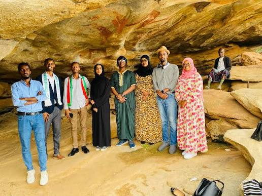
Cueva de Ardales: Spain's 66,000-Year Abstract Art

August 18, 2026

Cueva de Ardales, located near the town of Ardales in Málaga, southern Spain, is one of the most important prehistoric cave art sites in Europe. The cave contains hundreds of painted and engraved marks distributed throughout its underground chambers, including red dots, lines, hand-related markings, geometric forms, and other nonfigurative images. What makes Ardales especially significant is the evidence suggesting that some of its earliest painted features may date back more than 60,000 years, a period when Neanderthals were the only known human population in Europe.

The cave has therefore become central to one of the most important debates in prehistoric archaeology: Were Neanderthals capable of creating symbolic art?

For much of the history of archaeology, artistic expression was treated as one of the defining characteristics of modern humans. Neanderthals were often portrayed as technologically capable but symbolically limited. Discoveries from Cueva de Ardales and other Iberian sites have challenged this traditional interpretation, suggesting that Neanderthals may have deliberately used pigments and modified cave spaces long before the widespread arrival of Homo sapiens in Europe.

The Location and Discovery of Cueva de Ardales

Cueva de Ardales is situated within the limestone landscapes of Andalusia, a region rich in prehistoric caves and archaeological sites. The cave contains an extensive network of underground chambers, passages, and galleries.

Its interior is not simply a natural geological formation. Over thousands of years, humans repeatedly entered the cave and left evidence of their activities.

The archaeological record includes:

  • red pigment marks,

  • painted dots,

  • lines and abstract forms,

  • hand-related markings,

  • engravings,

  • and evidence of human visits across different prehistoric periods.

This long history of activity is important because the cave was not necessarily used by a single population or during a single period. Instead, different groups may have entered and interacted with the underground environment over tens of thousands of years.

What Makes the Art of Ardales Different?

Many famous European cave art sites are known for realistic depictions of animals such as horses, bison, deer, lions, and mammoths.

The earliest artistic evidence at Ardales is different.

Much of it is abstract or nonfigurative.

The images include:

  • dots,

  • finger marks,

  • lines,

  • pigment traces,

  • geometric patterns,

  • and deliberately colored surfaces.

To a modern observer, such markings may appear simple compared with detailed animal paintings. However, simplicity does not mean that the marks were accidental.

The placement and repeated use of pigments suggest deliberate human activity.

Creating a red mark deep inside a cave required people to obtain pigment, transport it into the underground environment, provide a source of light, and intentionally apply the material to a particular surface.

The Importance of the 66,000-Year Date

One of the most significant aspects of Cueva de Ardales is the scientific dating associated with some of its painted features.

Researchers have used uranium-thorium dating to examine mineral formations associated with pigment marks. In certain cases, mineral deposits that formed over painted surfaces can establish that the pigment underneath must be older than the mineral layer.

Some of the resulting minimum ages have suggested that certain red pigment applications are older than approximately 60,000 years, with dates sometimes discussed around 65,000 to 66,000 years.

This is extremely important because anatomically modern humans are generally not believed to have established a widespread presence in western Europe at that early date.

If the dating and interpretation of the pigment evidence are correct, Neanderthals become the most likely creators.

How Uranium-Thorium Dating Works

Unlike radiocarbon dating, uranium-thorium dating can be used to date certain mineral formations, particularly calcium carbonate deposits such as thin crusts that form on cave walls.

When water moves through limestone, it can deposit minerals onto surfaces.

Over time, these deposits may form thin layers above or below prehistoric paintings.

Scientists can analyze radioactive isotopes within these mineral layers to estimate when the deposits formed.

If a mineral crust formed over a painting, the painting must be older than the crust.

This provides a minimum age.

However, an important distinction must be made: dating the mineral layer does not necessarily provide the exact year when the painting was created. Instead, it establishes that the artwork existed before the mineral deposit formed.

This is why the interpretation of prehistoric cave art dates requires careful scientific analysis.

Neanderthals and Symbolic Behavior

For many years, Neanderthals were portrayed as fundamentally less creative than Homo sapiens.

This view was partly based on the assumption that sophisticated symbolic culture—including art, ornaments, and complex rituals—appeared only with modern humans.

However, archaeological discoveries have increasingly challenged this model.

Evidence associated with Neanderthals includes:

  • the deliberate use of mineral pigments,

  • possible personal ornaments,

  • modified bird feathers and claws,

  • intentional markings,

  • structured use of caves,

  • and possible symbolic treatment of objects and spaces.

The evidence from Ardales contributes to this growing reassessment.

If Neanderthals intentionally applied pigments to cave walls tens of thousands of years before modern humans arrived in the region, then symbolic expression cannot be considered exclusively a Homo sapiens invention.

Why Abstract Art Is Archaeologically Important

Modern audiences often associate art with recognizable images.

Prehistoric art, however, does not need to represent an animal or human figure to be meaningful.

A dot, line, hand mark, or colored surface may have communicated something important within a prehistoric cultural system.

The meaning could have involved:

  • group identity,

  • ritual,

  • memory,

  • territorial association,

  • communication,

  • initiation,

  • or social tradition.

The original meaning is impossible to recover with certainty.

However, the deliberate repetition of similar marks demonstrates that prehistoric people were interacting with cave spaces in ways that went beyond basic shelter or survival.

The Challenge of Working Inside a Cave

Creating marks inside a deep cave required preparation.

The artists—or perhaps ritual participants—would have needed light.

Possible prehistoric light sources included:

  • burning wooden torches,

  • small fires,

  • and lamps fueled by animal fat.

They also needed to carry pigments into the cave.

This required knowledge of where suitable minerals could be obtained and how they could be processed.

The act of entering darkness, carrying light, and deliberately applying pigment to cave walls may itself have been socially significant.

The process was likely very different from creating an image outdoors in daylight.

Ardales as a Long-Term Cultural Space

One of the most important features of Cueva de Ardales is that its archaeological history extends across multiple prehistoric periods.

Later populations also entered and used the cave.

This means that the site preserves evidence of repeated human engagement.

A cave wall could therefore become a kind of cultural archive.

Later visitors may have encountered marks created by people who had lived thousands of years earlier.

Whether those later populations understood the original meaning of the images is unknown, but the continued use of such spaces suggests that caves could retain cultural significance over extremely long periods.

The Debate Over Neanderthal Cave Art

The interpretation of very early cave art remains an active area of scientific discussion.

Researchers must carefully evaluate:

  • whether pigment was deliberately applied,

  • whether the dating is reliable,

  • the relationship between mineral layers and painted surfaces,

  • possible contamination,

  • and the broader archaeological context.

Scientific debate is not a weakness in archaeology.

It is an essential part of the process through which interpretations are tested and refined.

The discoveries from Ardales have nevertheless played an important role in changing discussions about Neanderthal capabilities.

Cueva de Ardales and Human Evolution

The cave forces archaeologists to reconsider a major question: What does it mean to be behaviorally modern?

For decades, symbolic art was frequently used as evidence of a cognitive boundary between Homo sapiens and other human populations.

But if Neanderthals independently created or participated in symbolic traditions, that boundary becomes much less clear.

Neanderthals may have possessed a far more complex cultural world than older reconstructions suggested.

Conclusion

Cueva de Ardales is one of the most significant archaeological sites for understanding the possible origins of Neanderthal art.

Its red pigment marks, abstract forms, and long history of human use demonstrate that prehistoric caves could serve as more than shelters.

They were also spaces where people deliberately interacted with darkness, stone, color, and symbolism.

The possibility that some of Ardales' earliest art dates to around 66,000 years ago has transformed the discussion surrounding Neanderthal intelligence and creativity.

Although researchers continue to investigate the chronology and meaning of individual markings, Ardales stands as powerful evidence that the origins of art and symbolic behavior may be far older—and involve more than one human population—than earlier generations of archaeologists.

← Newer Posts Older Posts →
Featured
image_2026-09-01_150407961.png
September 9, 2026
Dunadd Fort: Argyll's Inauguration Rock Carvings
September 9, 2026
Read more →
September 9, 2026
image_2026-09-01_150445885.png
September 9, 2026
Kilmartin Glen: Argyll's 5,000-Year Megalithic Landscape
September 9, 2026
Read more →
September 9, 2026
image_2026-09-01_150523753.png
September 9, 2026
Nether Largie: Argyll's Clyde Tomb Alignment
September 9, 2026
Read more →
September 9, 2026
image_2026-09-01_150612586.png
September 9, 2026
Ri Cruin: Argyll's Bronze Age Cairn Circle
September 9, 2026
Read more →
September 9, 2026
image_2026-09-01_150753980.png
September 9, 2026
Barnaluasgan: Argyll's Standing Stones
September 9, 2026
Read more →
September 9, 2026
image_2026-09-01_150644895.png
September 9, 2026
Ballymeanoch: Argyll's Kerbed Cairn
September 9, 2026
Read more →
September 9, 2026
read more

Powered by The archaeologist