• MAIN PAGE
  • LATEST NEWS
    • Lost Cities
    • Archaeology's Greatest Finds
    • Underwater Discoveries
    • Greatest Inventions
    • Studies
    • Blog
  • PHILOSOPHY
  • HISTORY
  • RELIGIONS
    • Africa
    • Anatolia
    • Arabian Peninsula
    • Balkan Region
    • China - East Asia
    • Europe
    • Eurasian Steppe
    • Levant
    • Mesopotamia
    • Oceania - SE Asia
    • Pre-Columbian Civilizations of America
    • Iranian Plateau - Central Asia
    • Indus Valley - South Asia
    • Japan
    • The Archaeologist Editor Group
    • Scientific Studies
    • Aegean Prehistory
    • Historical Period
    • Byzantine Middle Ages
    • Predynastic Period
    • Dynastic Period
    • Greco-Roman Egypt
  • Rome
  • PALEONTOLOGY
  • About us
Menu

The Archaeologist

  • MAIN PAGE
  • LATEST NEWS
  • DISCOVERIES
    • Lost Cities
    • Archaeology's Greatest Finds
    • Underwater Discoveries
    • Greatest Inventions
    • Studies
    • Blog
  • PHILOSOPHY
  • HISTORY
  • RELIGIONS
  • World Civilizations
    • Africa
    • Anatolia
    • Arabian Peninsula
    • Balkan Region
    • China - East Asia
    • Europe
    • Eurasian Steppe
    • Levant
    • Mesopotamia
    • Oceania - SE Asia
    • Pre-Columbian Civilizations of America
    • Iranian Plateau - Central Asia
    • Indus Valley - South Asia
    • Japan
    • The Archaeologist Editor Group
    • Scientific Studies
  • GREECE
    • Aegean Prehistory
    • Historical Period
    • Byzantine Middle Ages
  • Egypt
    • Predynastic Period
    • Dynastic Period
    • Greco-Roman Egypt
  • Rome
  • PALEONTOLOGY
  • About us
No results found

Midhowe Broch: Rousay's Wheelhouse Tower

September 14, 2026

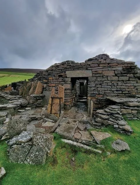
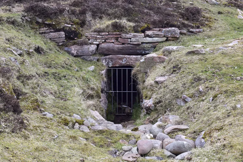
Midhowe Broch is one of Rousay's most impressive Iron Age monuments and an important example of the distinctive architectural traditions that developed in Orkney. The structure belongs to the broader family of monumental circular stone buildings that characterize Iron Age northern Scotland.

Its combination of massive stone construction, internal divisions, and relationship with the surrounding landscape provides valuable evidence for understanding architecture, settlement, social organization, and daily life during the Iron Age.

The Wheelhouse Tradition

Wheelhouses are distinctive Iron Age buildings found especially in northern Scotland.

Their defining characteristic is an interior organized around a central space with stone piers supporting or dividing the roof structure.

The term “wheelhouse” comes from the radial arrangement of these piers, which can resemble the spokes of a wheel when viewed from above.

This architecture demonstrates a sophisticated understanding of structural engineering.

Midhowe and Broch Architecture

Midhowe is associated with the broader broch tradition.

Brochs were characterized by thick circular walls and complex internal spaces.

The combination of monumental outer architecture and carefully organized internal areas demonstrates that Iron Age builders were not simply constructing defensive shelters.

They were designing buildings with multiple functional requirements.

Engineering Achievement

Constructing Midhowe required considerable planning.

Builders had to quarry or collect stone, transport it, and arrange it into stable walls.

The circular design distributed structural forces efficiently.

The radial internal supports helped create substantial enclosed spaces while maintaining structural stability.

The engineering achievement is especially impressive given the absence of modern machinery.

Domestic Life

The structure was part of a lived environment.

Cooking, food preparation, craft production, storage, and social interaction could all occur within or around the building.

The central hearth would have been important for warmth and cooking.

Stone shelves, benches, cells, and other architectural features provided practical spaces.

Agriculture

The inhabitants depended heavily on farming.

Livestock included cattle and sheep, while cereal cultivation provided grain.

Agricultural production required substantial labor and seasonal organization.

The community would have needed to store food for winter and maintain animals throughout the year.

Marine Resources

Rousay's coastline provided access to marine resources.

Fishing, shellfish collection, and seabird exploitation could supplement farming.

The sea also allowed travel to neighboring islands.

This combination of agricultural and maritime resources was a characteristic feature of Orkney's island economy.

Social Status

The size and complexity of Midhowe raises questions about social hierarchy.

Monumental architecture can function as a statement of collective identity or individual authority.

The building may have been associated with a prominent family or community group.

Its construction demonstrates that people could mobilize labor beyond the scale required for ordinary houses.

Changing Interpretations

Archaeological interpretation of brochs has changed considerably.

Earlier scholars often emphasized military functions.

More recent interpretations recognize a wider range of possibilities.

Brochs could have been residences, community centers, storage facilities, defensive structures, symbols of authority, or combinations of these.

The archaeological evidence does not support a single universal explanation for every broch.

Preservation

Coastal and island archaeological sites face significant threats.

Weathering, erosion, vegetation growth, and human activity can damage exposed stone structures.

Preserving Midhowe therefore requires continued archaeological monitoring.

Digital recording can create detailed records that remain valuable even if parts of the monument deteriorate.

Conclusion

Midhowe Broch demonstrates the architectural sophistication of Iron Age Rousay.

Its circular construction, complex internal organization, and relationship with the surrounding agricultural and maritime landscape reveal a society capable of advanced engineering and substantial social coordination.

The monument is important not only because of its impressive stonework but because it provides evidence for the people who designed, constructed, inhabited, and maintained it.

Through Midhowe, the Iron Age of Rousay becomes a tangible world of farmers, craftspeople, sailors, households, communities, and leaders whose architecture still dominates the landscape.

Westness: Rousay's Multi-Period Site

September 14, 2026

Westness on Rousay is one of the most important examples of a multi-period archaeological landscape in Orkney. The significance of such a site lies in the accumulation of evidence from different periods, demonstrating that the same landscape could be occupied, modified, abandoned, and reused repeatedly over thousands of years.

Rather than representing one isolated historical moment, Westness provides a long archaeological sequence connecting prehistoric communities with later Iron Age, Norse, medieval, and potentially post-medieval activity.

What Is a Multi-Period Site?

Archaeologists use the term “multi-period” to describe places containing evidence from multiple chronological periods.

Such sites are especially valuable because they reveal continuity and change.

A landscape may remain attractive because of its fertile soils, access to water, coastal resources, defensibility, or strategic position.

Each generation can then reinterpret the location according to its own needs.

Prehistoric Occupation

Rousay was heavily occupied during prehistory.

Neolithic communities established settlements and constructed burial monuments.

Bronze Age and Iron Age populations later modified the landscape.

The presence of earlier monuments would have remained visible to later inhabitants.

This created a landscape filled with memories and physical reminders of earlier communities.

Iron Age Development

Iron Age communities in Orkney constructed substantial stone buildings, including brochs and wheelhouses.

These structures reflect complex societies with developed agricultural economies and strong local identities.

Iron Age settlement around Westness demonstrates the continuation of intensive occupation.

Norse Settlement

The arrival of Norse settlers introduced major cultural changes.

Language shifted toward Norse forms, new settlement patterns emerged, and Scandinavian material culture became widespread.

Westness became part of the Norse agricultural landscape.

Longhouses, farms, burial sites, and imported objects provide evidence for this period.

Farming Through the Centuries

One of the most important aspects of Westness is the persistence of farming.

Although technology changed, agriculture remained fundamental.

Different communities cultivated crops, raised livestock, produced textiles, and exploited marine resources.

This continuity demonstrates the long-term productivity of Rousay's environment.

The Maritime Economy

Westness also reflects Orkney's maritime orientation.

Fishing and marine resource exploitation supplemented farming.

Boats provided transportation between islands.

During the Norse period, maritime connections expanded dramatically, linking Orkney with the wider North Atlantic.

Burials and Belief

Multi-period sites can contain evidence for changing burial practices.

Prehistoric communities used chambered tombs and other monuments.

Iron Age burial practices varied considerably.

Norse communities introduced Scandinavian funerary traditions before Christian burial practices became dominant.

Later Christian cemeteries provide evidence for another major transformation.

Archaeological Methods

Understanding a multi-period site requires careful stratigraphic analysis.

Archaeologists must determine which deposits belong to which periods.

Radiocarbon dating, artifact typology, soil analysis, environmental archaeology, and architectural study can all contribute.

Digital mapping is particularly useful because it allows researchers to visualize relationships between structures.

The Importance of Continuity

Westness demonstrates that landscapes can remain important even when cultures change.

A Neolithic farmer, Iron Age household, Norse settler, and medieval tenant might all have used the same general area for different purposes.

The physical landscape therefore acts as a historical archive.

Conclusion

Westness is important because it reveals the extraordinary depth of Rousay's human history.

Its multi-period character demonstrates that the island was repeatedly occupied by communities with different technologies, economies, religious beliefs, and political structures.

Studying such sites allows archaeologists to move beyond isolated historical periods and instead examine long-term processes of settlement, adaptation, cultural change, and landscape memory.

Westness is therefore not simply a collection of ruins. It is a record of generations of people repeatedly making a home in the same remarkable landscape.

Knowe of Swandro: Rousay's Viking Longhouse

September 14, 2026

The Knowe of Swandro on Rousay is associated with the long history of Norse settlement and occupation in Orkney. The Viking Age and subsequent Norse period transformed the islands culturally, politically, economically, and linguistically. Archaeological sites associated with Viking and medieval settlement provide evidence for this transformation and demonstrate how Norse communities adapted to an environment already occupied by prehistoric societies.

A longhouse is particularly important because it represents a form of domestic architecture closely associated with northern European farming communities. Such structures could function as residences, agricultural centers, workshops, and social spaces.

The Arrival of the Norse

Norse influence in Orkney began during the Viking Age.

Scandinavian settlers and raiders entered the North Atlantic world, establishing connections across the Northern Isles, Scotland, Ireland, Iceland, and eventually Greenland and beyond.

Orkney became one of the most important Norse territories in the North Atlantic.

The islands were strategically positioned along maritime routes connecting Scandinavia with the British Isles and the North Atlantic.

The Longhouse

A longhouse was typically an elongated building organized around a central interior space.

Its design was well suited to farming communities.

People and animals could occupy different parts of the building, depending on local architectural traditions.

The central hearth was fundamental.

It provided heat and light while serving as a cooking area and a focus of domestic life.

Farming and Household Economy

Norse communities in Rousay relied heavily on agriculture.

Cattle, sheep, pigs, and horses were important livestock.

Cereals were cultivated where conditions allowed.

Dairy production could be particularly important in northern environments because milk could be transformed into products that lasted longer, including butter and cheese.

The sea supplemented farming through fishing and other marine resources.

Norse Material Culture

Archaeological remains from Norse settlements can include pottery, spindle whorls, metal objects, bone tools, gaming pieces, and personal ornaments.

Textile production was especially important.

Wool provided material for clothing, blankets, sails, and other products.

Spinning and weaving could occur within the household, making textile production an essential part of the domestic economy.

Social Life in the Longhouse

The longhouse was more than a shelter.

It was a social environment.

Families ate together, worked together, entertained visitors, and passed stories between generations.

The household could include extended family members, dependents, workers, and possibly enslaved people.

Hospitality was an important feature of Norse social culture, particularly in societies where political relationships depended on personal networks.

Maritime Society

Rousay's Norse inhabitants were experienced seafarers.

Boats connected settlements with neighboring islands and distant regions.

Travel allowed communities to exchange goods and maintain political relationships.

Norse maritime activity also facilitated the movement of ideas, technologies, languages, and religious practices.

Christianity and Cultural Change

During the medieval period, Christianity became increasingly important in Orkney.

The transition from Norse pagan traditions to Christianity did not occur instantly.

Instead, religious practices changed gradually.

Burial evidence, churches, crosses, and imported objects provide archaeological clues to this transformation.

Archaeological Importance

The Knowe of Swandro is valuable because it contributes to the study of continuity and change.

The landscape had already been occupied for thousands of years before the arrival of Norse settlers.

Norse communities therefore encountered an existing archaeological environment filled with ancient monuments.

They may have reused, avoided, or incorporated earlier places into their own landscape.

Coastal Change

Coastal archaeology is particularly vulnerable to erosion.

Rousay's coastline has experienced natural changes over centuries, threatening archaeological deposits.

Sites such as Swandro demonstrate the importance of recording archaeological remains before they are lost.

Modern archaeology increasingly combines excavation with digital survey, photogrammetry, drone mapping, and environmental monitoring.

Conclusion

The Knowe of Swandro represents the Norse transformation of Rousay and the wider Orkney Islands.

Its longhouse tradition provides evidence for farming, household production, maritime activity, social organization, and cultural change.

The site also demonstrates the value of studying ordinary domestic settlements rather than focusing exclusively on castles, churches, and elite monuments.

Within the walls of a longhouse lived the people who transformed Orkney into one of the most distinctive Norse societies of the medieval North Atlantic.

Wasbister: Rousay's Neolithic

September 14, 2026

Wasbister on Rousay forms part of the remarkable Neolithic archaeological landscape of Orkney. Rousay is sometimes described as an “archaeological treasure island” because its relatively small area contains an extraordinary concentration of prehistoric monuments, settlements, tombs, and later remains.

The Neolithic evidence associated with Wasbister contributes to understanding how farming communities inhabited, organized, and transformed the island thousands of years ago.

Neolithic Rousay

The Neolithic period brought profound changes to northern Scotland.

Communities increasingly practiced agriculture and animal husbandry, constructed permanent or semi-permanent settlements, developed distinctive pottery traditions, and created monumental burial architecture.

Rousay became part of this wider cultural transformation.

Its fertile land and access to marine resources made it capable of supporting agricultural communities while its location within the Orkney archipelago facilitated communication.

Farming Communities

Neolithic farmers depended on a mixture of crops and livestock.

Barley was especially important because of its suitability to northern conditions. Other cereals may also have been cultivated.

Cattle, sheep, and pigs provided meat and secondary products.

However, the people of Rousay were not exclusively agricultural.

The sea remained an important source of food and transportation.

Houses and Household Life

Neolithic homes were centers of production and social life.

Cooking took place around hearths. Grain was processed with stone tools, pottery was used for food preparation and storage, and textiles may have been produced within households.

Children would have grown up participating in many aspects of domestic production.

The household was therefore simultaneously a family unit, workplace, and social institution.

Monumental Architecture

Rousay is especially famous for chambered tombs.

These monuments were designed to accommodate the remains of multiple individuals and were likely associated with complex funerary practices.

Their construction demonstrates that Neolithic communities could mobilize considerable labor.

The relationship between settlements and tombs suggests that the dead were not separated completely from everyday life. Ancestral monuments remained visible components of the landscape.

Social Organization

Monument building provides evidence for cooperation.

Large construction projects required people to coordinate labor and resources.

This does not necessarily mean that Neolithic Orkney possessed centralized states.

Communities may instead have organized work through kinship, ritual authority, communal decision-making, or temporary leadership.

Pottery and Material Culture

Neolithic pottery provides archaeologists with valuable evidence.

Different vessel styles can help identify cultural relationships between communities.

Residues can sometimes reveal what vessels contained.

Stone tools provide additional evidence for woodworking, agriculture, animal processing, and other activities.

Environmental Adaptation

The inhabitants of Rousay had to manage a northern island environment.

Wind, rainfall, temperature, and soil conditions affected agricultural production.

Diversification was therefore essential.

A household that combined crops, livestock, fishing, shellfish gathering, and other activities would have been better positioned to withstand fluctuations in any single resource.

Maritime Connections

Rousay's position meant that travel by boat was essential.

People could visit neighboring islands, exchange materials, attend gatherings, and maintain social relationships.

The sea was therefore a connective network rather than a boundary.

This helps explain the cultural similarities seen across the Orkney Islands.

Conclusion

Wasbister's Neolithic context contributes to the broader understanding of one of Europe's most remarkable prehistoric landscapes.

The site represents communities that combined agriculture, livestock management, maritime resources, domestic production, and monumental construction.

Its significance is especially clear when considered alongside the many prehistoric monuments of Rousay.

Together, these sites reveal that Neolithic Orkney was not a peripheral society but a complex and highly organized island world with distinctive cultural traditions and extensive social connections.

Loch of Stenness: Mainland's Crannog

September 14, 2026

The archaeological tradition of crannogs represents one of the most intriguing forms of prehistoric settlement in Scotland. A crannog is generally understood as a human-made or substantially modified island or platform constructed within a lake or loch. Such sites could serve as dwellings, refuges, storage places, or centers of specialized activity.

A crannog associated with the Loch of Stenness landscape contributes to the broader archaeological understanding of how communities in Orkney interacted with wetlands and inland waters. Although Orkney is internationally famous for its stone monuments and coastal settlements, inland water environments also formed part of the prehistoric landscape.

What Is a Crannog?

Crannogs are particularly common in Scotland and Ireland.

They vary considerably in construction. Some were built by creating artificial islands from timber, stone, brushwood, and other materials. Others incorporated existing small islands and reinforced them with structural additions.

Their locations in water could provide several advantages.

An island settlement was naturally separated from the surrounding land, potentially offering protection and controlled access.

Construction Techniques

Building a crannog required an intimate understanding of wetland environments.

Timber posts could be driven into lake sediments, while stones and organic materials were used to create stable platforms.

In some examples, layers of brushwood, peat, timber, and stone were carefully arranged.

Such construction demonstrates sophisticated engineering knowledge.

Prehistoric builders had to understand water levels, sediment stability, structural weight, and material decay.

Why Build on Water?

The reasons for constructing a crannog probably varied.

Security was one possibility.

A settlement surrounded by water was more difficult to approach than an ordinary house. This could be valuable during periods of social conflict.

Privacy and social status may also have mattered.

An island dwelling could have restricted access and created a visually impressive residence.

Crannogs might additionally have been used for storage, craft production, or ceremonial purposes.

Life on a Crannog

Daily life would still have depended upon ordinary economic activities.

Residents needed food, fuel, water, tools, clothing, and building materials.

Agriculture could take place on surrounding land, while fishing and aquatic resources were immediately accessible.

Boats would have been particularly important because they connected the settlement with the shore.

Archaeological Preservation

Wet environments can preserve materials that normally disappear.

Waterlogged wood may survive for centuries or millennia because oxygen is limited. Organic objects such as wooden tools, structural timbers, and plant remains can therefore provide exceptional information.

This makes wetland archaeology particularly valuable.

A timber preserved in waterlogged sediment can reveal construction techniques, tree species, and sometimes even the season in which a tree was felled.

The Loch of Stenness Landscape

The Loch of Stenness is located within one of Orkney's most archaeologically significant regions.

The surrounding landscape contains famous Neolithic monuments, including the Stones of Stenness and the broader Heart of Neolithic Orkney World Heritage landscape.

This creates an important archaeological context.

The presence of settlement activity in or around the loch demonstrates that people used the same landscape for multiple purposes over thousands of years.

Relationship with the Wider Landscape

A water-based settlement should never be considered in isolation.

The inhabitants would have interacted with nearby agricultural areas, settlements, monuments, and transportation routes.

The loch itself could function as a resource and a route.

Its ecological environment may have provided fish, birds, plants, reeds, and other materials.

Climate and Environmental Change

Water levels and vegetation can change dramatically over long periods.

Archaeologists therefore use environmental evidence to reconstruct prehistoric landscapes.

Pollen analysis can reveal vegetation history, while sediment cores can record changes in climate, erosion, agriculture, and human activity.

These techniques allow researchers to understand how the environment surrounding a crannog evolved.

Broader Significance

Crannogs challenge the assumption that prehistoric settlements were necessarily located on dry land.

They demonstrate that communities deliberately occupied environments that modern observers might consider difficult.

This required specialized knowledge and technology.

Water was not simply an obstacle; it could become part of the architecture itself.

Conclusion

The Loch of Stenness crannog tradition demonstrates the ingenuity of prehistoric communities in adapting settlement architecture to aquatic environments.

Its importance lies in the combination of engineering, environmental knowledge, economic activity, and social organization required to establish a stable settlement on or beside water.

When considered alongside the extraordinary Neolithic monuments surrounding the Loch of Stenness, the site contributes to a broader picture of Orkney as a landscape repeatedly transformed by communities with sophisticated knowledge of their environment.

Hillock of Bay: Stronsay's Broch

September 14, 2026

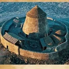
The Hillock of Bay broch on Stronsay belongs to the remarkable tradition of Iron Age monumental stone architecture found throughout Orkney and northern Scotland. Brochs are among the most distinctive prehistoric structures in Britain, characterized by circular towers constructed with massive dry-stone walls.

Their function remains one of the enduring questions of Scottish archaeology. Once interpreted primarily as defensive structures, brochs are now understood as complex buildings whose roles may have included residence, status display, communal gathering, storage, protection, and political authority.

The Architecture of Brochs

Brochs were constructed using a sophisticated form of dry-stone masonry.

Two concentric walls created a thick structural envelope. Within this wall thickness, builders could incorporate stairways, galleries, and small chambers.

The circular design distributed structural loads effectively and allowed builders to create tall structures without mortar.

The Hillock of Bay structure therefore reflects considerable architectural knowledge.

Engineering Without Modern Equipment

Iron Age builders did not possess cranes, trucks, or powered machinery.

Instead, they relied upon human labor, stone-working techniques, levers, sledges, ropes, and carefully planned construction.

Large stones could be moved using coordinated teams. Smaller stones could be carried individually or transported using simple devices.

The successful construction of a broch demonstrates that prehistoric communities possessed both practical engineering knowledge and organizational capacity.

The Broch as a Social Monument

A broch would have been highly visible within its surrounding landscape.

Its monumental architecture may have communicated the wealth and authority of its occupants.

Building such a structure required resources. Food had to support workers, stone had to be obtained and transported, and construction had to be coordinated.

The ability to mobilize labor may itself have been a source of political power.

Domestic Life Inside the Broch

Despite their monumental appearance, brochs were not necessarily empty fortresses.

Evidence from other Scottish brochs demonstrates that people lived, cooked, worked, and stored materials inside them.

Central hearths provided warmth and supported cooking. Stone furniture, storage spaces, and internal cells allowed a range of domestic activities.

The structure could therefore function as both residence and social center.

Agriculture and Livestock

The inhabitants of the Hillock of Bay community would have depended heavily on agriculture.

Cattle, sheep, and pigs were important domestic animals. Cereal cultivation provided carbohydrates, while livestock supplied meat and other products.

Agricultural communities also required storage systems to survive through winter.

Brochs may sometimes have provided secure storage environments, although their precise economic roles varied.

Maritime Resources

Stronsay's island position meant that the sea was central to daily life.

Fishing could provide protein, while shellfish and seabirds offered additional food.

Boats also enabled communication with neighboring communities.

The inhabitants of the broch therefore operated within a maritime landscape rather than an isolated terrestrial one.

Warfare and Protection

Defensive functions cannot be dismissed.

Thick stone walls could provide substantial protection against attacks. Controlled entrances and elevated positions may have improved security.

However, not every broch shows evidence of violent conflict.

The safest interpretation is that protection may have been one component of a broader social function.

Archaeological Interpretation

Archaeologists increasingly study brochs through landscape analysis rather than examining them individually.

The location of the Hillock of Bay structure can be compared with nearby farms, other monumental buildings, agricultural land, and coastal routes.

This approach can reveal whether the broch occupied a strategic location, controlled access to resources, or served as a local community center.

Later Reuse

Like many prehistoric monuments, the broch may have continued to influence the landscape after its original period of use.

Later communities encountered the ruins as prominent landmarks. Stone may have been reused, while the site itself could acquire new meanings.

Archaeological sites are therefore often palimpsests containing multiple periods of activity.

Conclusion

The Hillock of Bay broch represents the technological skill, social organization, and architectural ambition of Iron Age Stronsay.

Its thick stone construction reflects advanced dry-stone engineering, while its location demonstrates the integration of architecture with agriculture, maritime activity, and community organization.

Rather than viewing it simply as a fortress, it is more useful to understand the broch as a multifunctional monument embedded within a complex society.

Its surviving remains provide a valuable opportunity to study how Iron Age communities expressed identity, organized resources, and transformed the Orkney landscape.

Whitehill: Stronsay's Neolithic

September 14, 2026

Whitehill on Stronsay represents part of the island's Neolithic archaeological heritage, a period during which communities across Orkney experienced profound changes in settlement, agriculture, architecture, technology, and social organization. The Neolithic, or “New Stone Age,” is generally associated with the adoption of farming and new forms of material culture, although the transition was neither sudden nor uniform.

In Orkney, the Neolithic produced some of the most remarkable prehistoric monuments in Europe. Settlements, chambered tombs, stone circles, standing stones, and ceremonial complexes demonstrate that communities were capable of coordinating substantial construction projects while maintaining productive agricultural economies.

The Neolithic Transformation

The Neolithic period marked a major transformation in human life.

Earlier Mesolithic communities relied heavily on hunting, fishing, gathering, and other forms of mobile or semi-mobile subsistence. Neolithic communities increasingly practiced agriculture and animal husbandry.

This did not mean that hunting and gathering disappeared.

Instead, farming became part of a diversified economy.

Crops such as barley could be cultivated, while cattle, sheep, and pigs provided meat, milk, hides, wool, and other resources.

Settlement on Stronsay

Island environments such as Stronsay offered attractive opportunities for Neolithic communities.

Fertile soils supported cultivation, while grasslands provided grazing. The surrounding sea supplied fish and shellfish, and boats allowed people to travel between islands.

Neolithic settlements were not simply places where people slept.

They were centers of production, food preparation, tool manufacture, social interaction, and ritual activity.

Houses and Domestic Architecture

Neolithic houses in Orkney are often characterized by substantial stone construction.

Walls could be thick, and interiors were carefully organized. Central hearths provided warmth and served as cooking areas.

Furniture and household equipment were usually made from stone, wood, bone, and other organic materials.

Because organic materials rarely survive in the archaeological record, archaeologists often reconstruct domestic life indirectly through stone tools, pottery, food remains, and structural features.

Agriculture and Food Production

Farming required knowledge of soils, seasons, rainfall, and animal behavior.

Barley was an especially important crop in northern Britain. Its ability to tolerate relatively cool conditions made it well suited to the Orkney environment.

Cereal grains could be processed using stone querns or grinding stones.

Animals provided a different set of resources. Cattle and sheep were valuable not only for meat but also for milk, hides, wool, and bone.

The combination of agriculture and marine resources gave island communities considerable dietary flexibility.

Pottery and Household Technology

Neolithic Orkney is famous for distinctive pottery traditions.

Grooved Ware is particularly associated with later Neolithic Orkney and appears at several major sites.

Earlier pottery traditions also existed and were used for cooking and storage.

Pottery provides archaeologists with valuable information because vessels can sometimes preserve residues from foods or other substances.

Monument Building

Perhaps the most extraordinary characteristic of Neolithic Orkney is its monumental architecture.

Communities constructed chambered tombs, stone circles, standing stones, and large ceremonial buildings.

The scale of such structures indicates that prehistoric society could organize substantial communal labor.

Monuments may have served religious, social, political, and ancestral purposes simultaneously.

The Importance of Ancestry

Neolithic burial monuments demonstrate that the dead occupied an important position within society.

Chambered tombs sometimes contained the remains of numerous individuals rather than a single burial.

This suggests that communities may have viewed burial places as collective ancestral spaces.

The repeated deposition and manipulation of human remains may have formed part of complex funerary traditions.

Seafaring and Inter-Island Connections

The people of Neolithic Orkney were maritime travelers.

The islands could be reached by boats, and archaeological similarities across Orkney demonstrate connections between communities.

Stone, pottery styles, ideas, and perhaps people moved across the archipelago.

The sea therefore functioned as a transportation network.

Archaeological Significance of Whitehill

Whitehill contributes to understanding the broader distribution of Neolithic activity across Stronsay.

Even sites without spectacular surviving monuments are important because they demonstrate that prehistoric settlement extended beyond the famous archaeological centers.

They help reconstruct population density, land use, agricultural expansion, and the relationship between domestic and ceremonial landscapes.

Conclusion

Whitehill's Neolithic significance lies within the broader story of Stronsay's transformation during the early farming period.

Its archaeological context reflects a society that combined agriculture, livestock husbandry, maritime resources, stone architecture, pottery production, and communal monument building.

The Neolithic inhabitants of Stronsay were not isolated farmers living at the edge of Europe. They were members of interconnected island communities participating in one of the most important transformations in prehistoric human history.

Their legacy survives in the archaeological landscape that remains visible today.

Green Hill: Stronsay's Cairn

September 14, 2026

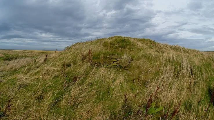
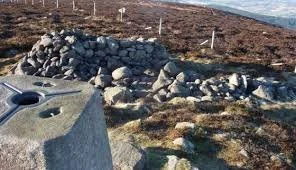
The cairn at Green Hill on Stronsay belongs to the long tradition of prehistoric monument construction that characterizes the Orkney Islands. Cairns are among the most enduring forms of prehistoric architecture in Britain. Constructed primarily from stone and earth, they were frequently associated with burial, remembrance, ceremonial activity, and the creation of enduring places within the landscape.

Although the appearance of a cairn may seem simple compared with a monumental stone circle or broch, these structures often represent complex social practices. Their construction required the deliberate collection and movement of stone, while their use could involve ceremonies involving multiple generations.

Cairns and the Prehistoric Landscape

Orkney possesses an exceptionally rich archaeological landscape. Neolithic chambered tombs, Bronze Age cairns, standing stones, stone circles, settlements, and later monuments exist across the islands.

A cairn was not simply a pile of stones.

Its shape, location, materials, and relationship with surrounding features could carry cultural meaning. The act of constructing a monument transformed an ordinary area into a socially significant place.

Green Hill should therefore be understood as part of a landscape in which communities repeatedly interacted with the physical environment.

Burial and Commemoration

Many prehistoric cairns were connected with the treatment of the dead.

Burial monuments provided places where communities could commemorate ancestors. The dead could become part of the landscape itself, allowing later generations to encounter physical reminders of their predecessors.

This practice had important social consequences.

Ancestors could provide communities with a sense of continuity. A monument established a connection between people living in the present and generations who had occupied the same landscape in the past.

Monument Construction

Building a cairn required organized labor.

Even when individual stones were relatively small, a substantial monument required many loads of material. Workers had to collect stones, transport them, and arrange them deliberately.

Construction may have occurred during communal events.

Such gatherings would have created opportunities for people from different households to cooperate, exchange information, share food, conduct ceremonies, and reinforce social relationships.

Monument building was therefore simultaneously an architectural and social activity.

Choosing the Location

The position of a prehistoric monument was rarely meaningless.

Builders may have selected prominent hills or ridges because they provided visibility. A monument placed on elevated ground could be seen from considerable distances.

Green Hill's location is therefore relevant to understanding how the monument interacted with the surrounding landscape.

Visibility could have helped create territorial associations, commemorate ancestors, or establish a recognizable landmark.

Materials and Meaning

Stone itself could possess cultural significance.

Different rocks have different colors, textures, shapes, and physical properties. Prehistoric communities may have recognized these characteristics even if their symbolic meanings are impossible to reconstruct today.

The act of selecting and arranging stones transformed natural material into architecture.

Later Alteration and Reuse

Prehistoric monuments frequently underwent modification.

A cairn could be enlarged, disturbed, reopened, or incorporated into later agricultural landscapes. Later communities sometimes removed stones for construction or field clearance.

These processes complicate archaeological interpretation because the monument visible today may represent multiple phases of activity.

Archaeological Evidence

Archaeologists study cairns using several types of evidence.

Excavation can reveal construction layers, burial deposits, hearths, artifacts, and episodes of rebuilding. Radiocarbon dating may establish chronological sequences when suitable organic material survives.

Landscape archaeology can determine how the monument relates to settlements, fields, standing stones, and other archaeological sites.

Modern non-invasive methods such as geophysical survey can sometimes reveal buried structures without extensive excavation.

The Social Meaning of Cairns

Cairns provide evidence for communities that possessed concepts of memory, place, and ancestry.

The construction of a permanent monument suggests that people cared about how locations would be experienced by future generations.

This is particularly significant in island societies. A prominent monument could become a fixed point within a changing landscape.

Stronsay's Archaeological Importance

Stronsay contains evidence from several prehistoric and historic periods. The presence of monuments such as cairns and later settlements demonstrates that the island's landscape was repeatedly occupied and reinterpreted.

Green Hill therefore contributes to a much longer story.

The same general landscape could contain memories of Neolithic communities, Bronze Age groups, Iron Age farmers, Norse settlers, and later inhabitants.

Conclusion

Green Hill's cairn represents more than an archaeological mound. It is evidence of prehistoric communities deliberately transforming their environment to commemorate people, establish places of significance, and create monuments capable of surviving beyond individual lifetimes.

Its archaeological value lies in its ability to connect architecture with social memory.

Through cairns such as Green Hill, archaeologists can investigate not only how prehistoric people built structures but also how they understood ancestry, landscape, community, and the passage of generations.

Torness: Stronsay's Broch

September 14, 2026

The broch at Torness on Stronsay belongs to one of the most distinctive architectural traditions of Iron Age northern Scotland. Brochs are massive, circular stone towers found primarily in northern Scotland and the Northern Isles, particularly Orkney and Shetland. Their impressive walls, complex internal architecture, and considerable labor requirements have made them some of the most recognizable archaeological monuments of Scotland's prehistoric landscape.

Torness is therefore significant not merely because it preserves the remains of an Iron Age building, but because it forms part of a much larger architectural and social tradition that transformed the northern Scottish landscape during the later prehistoric period.

What Was a Broch?

A broch is generally characterized by a circular plan and a thick double-skinned stone wall. The space between the inner and outer faces of the wall could contain galleries, chambers, stairways, and other architectural features.

Many brochs were originally extremely substantial structures. Their walls could reach several meters in thickness, while surviving examples demonstrate that some towers may originally have stood considerably higher than their present ruins.

The exact function of brochs remains debated.

Older interpretations often described them primarily as defensive towers. Modern archaeology generally takes a more cautious approach. Brochs could certainly provide protection, but their monumental architecture may also have expressed wealth, identity, status, authority, and community organization.

Construction of the Torness Broch

Constructing a broch required enormous quantities of stone.

Builders first had to select an appropriate location and gather suitable building material. Stone then needed to be transported, positioned, and carefully fitted into walls.

The double-wall construction characteristic of brochs provided both structural stability and internal space. Galleries and chambers within the wall could serve practical purposes while also reducing the amount of solid masonry required.

No mortar was necessary in many traditional dry-stone constructions. Stability depended upon careful stone placement, wall geometry, weight distribution, and skilled masonry.

The construction process would have required coordinated labor. This suggests that broch-building societies possessed mechanisms for organizing substantial communal projects.

Interior Organization

Broch interiors often contained a central open area surrounded by architectural features.

A hearth was typically an important component of Iron Age domestic architecture. Cooking, warmth, craft production, and social interaction could all take place around the central fire.

Stone-built cells within the walls provided additional space. Some may have been used for storage, while others may have served specialized functions.

Stairways built into the thickness of the wall are among the most remarkable features associated with brochs. In some examples, these staircases may have connected multiple levels.

Defense or Display?

The question of whether brochs were primarily defensive remains controversial.

Their thick walls certainly provided protection. However, a tower with monumental architecture could also function as a visible statement of social power.

Imagine approaching an island settlement and seeing a massive circular stone structure rising above the surrounding landscape. The monument would immediately communicate that its inhabitants possessed considerable resources and organizational capacity.

Architecture can therefore operate as a form of social communication.

The Torness broch should be understood within this broader framework rather than reduced to the label “fort.”

Brochs and Social Hierarchy

The construction of a broch may indicate that communities were capable of mobilizing labor and resources on a large scale.

This raises questions about leadership.

Who organized construction? Who controlled access to the building? Did particular families or social groups possess greater authority?

Archaeologists continue to debate these issues because the archaeological record rarely provides straightforward answers.

However, the sheer scale of broch architecture indicates that Iron Age communities were socially sophisticated.

Agriculture and Maritime Life

The Torness community would have existed within an island economy.

Agriculture probably supplied cereals and livestock, while the sea offered fish, shellfish, seabirds, and opportunities for transportation.

The combination of land and sea resources made Orkney particularly well suited to diversified economies.

Boats also allowed communication with neighboring islands. The people of Torness therefore belonged to a maritime society in which the sea was not simply a barrier but a route.

Technology and Craft

Broch communities were not simply farmers.

Craft activities could include textile production, pottery manufacture, woodworking, bone working, and metalworking.

Iron tools improved the ability to process wood and agricultural products. Wool production required spinning and weaving, while animal bones could be turned into tools or ornaments.

Archaeological deposits associated with brochs can therefore reveal a surprisingly diverse range of activities.

The Broch in the Orkney Landscape

Torness should also be considered alongside other Iron Age monuments on Stronsay and the surrounding islands.

Orkney contains numerous brochs and other forms of substantial stone architecture. Their distribution demonstrates that monumental construction was widespread rather than restricted to one political center.

This raises the possibility that brochs served as focal points for local communities.

They may have functioned as residences, meeting places, storage centers, ceremonial spaces, defensive refuges, or combinations of these roles.

Later History

Like many prehistoric monuments, the broch did not necessarily become irrelevant after the Iron Age.

Ancient structures could remain visible and sometimes continue to influence settlement patterns. Later inhabitants might reuse stone, occupy nearby areas, or attach stories and traditions to earlier ruins.

The physical survival of a broch therefore extends its significance beyond the period in which it was constructed.

Archaeological Interpretation

Modern archaeological investigation combines excavation with landscape analysis, environmental science, radiocarbon dating, artifact studies, and architectural recording.

Rather than asking only “What was this building used for?”, archaeologists can ask broader questions:

How did its inhabitants obtain food?

What was their relationship with neighboring communities?

How did they organize labor?

What resources were available locally?

How did the settlement change over time?

These questions transform the broch from an isolated ruin into evidence for a complex society.

Conclusion

Torness Broch is an important representation of Orkney's Iron Age architectural heritage. Its massive stone construction demonstrates advanced dry-stone engineering, while its location reflects the agricultural and maritime economy of Stronsay.

Whether its primary role was defensive, domestic, social, ceremonial, or a combination of these functions, the broch clearly represented something more substantial than an ordinary house.

Its monumental character reflects a society capable of organizing labor, managing resources, and constructing buildings intended to endure.

Today, the surviving ruins provide a direct connection to an Iron Age world in which architecture, agriculture, maritime activity, community identity, and social authority were closely interconnected.

Iron Age Farm: Stronsay's Settlement

September 14, 2026

The Iron Age settlement remains of Stronsay provide an important window into the agricultural communities that lived in Orkney more than two thousand years ago. Although Stronsay is better known today for its dramatic coastline, fertile farmland, prehistoric monuments, and later Norse heritage, its archaeological landscape also preserves evidence for Iron Age communities whose lives were centered on farming, livestock, craft production, and the management of a small island environment.

The term “Iron Age farm” does not necessarily describe a single isolated farmhouse. In the Orkney context, it can refer to a broader archaeological complex consisting of domestic structures, agricultural areas, storage facilities, hearths, refuse deposits, boundaries, and sometimes defensive or monumental architecture. These settlements reveal that Iron Age society in northern Scotland was organized around communities capable of adapting their architecture and economy to local environmental conditions.

Stronsay and the Iron Age Landscape

Stronsay lies within the Orkney archipelago, an environment that has supported human occupation for thousands of years. Its relatively productive soils, access to marine resources, freshwater, and extensive coastal environments made the island attractive to prehistoric communities.

By the Iron Age, communities across Orkney had developed distinctive architectural traditions. These included roundhouses, souterrains, wheelhouses, brochs, and enclosed settlements. Not every community built monumental structures. Many people lived in comparatively ordinary farming settlements whose archaeological remains are less visually impressive but potentially more representative of everyday life.

The location of an Iron Age farm was influenced by several practical considerations. Farmers needed access to cultivable land and grazing areas while remaining close enough to freshwater and marine resources. Coastal proximity also provided opportunities for fishing, gathering shellfish, collecting seaweed, and exploiting seabirds and other marine resources.

The island environment encouraged economic flexibility. Agriculture alone could be risky, particularly in a northern climate where weather could dramatically influence harvests. Combining crop cultivation with animal husbandry and marine resource exploitation provided a more resilient economic strategy.

The Farm as a Household Center

An Iron Age farm was fundamentally a household-based economic unit. The same people who lived within the settlement were usually involved in producing much of what they consumed.

Cattle, sheep, and pigs could provide meat, milk, hides, bone, and other useful materials. Sheep were particularly valuable because they supplied wool as well as meat. Cattle could also represent wealth and social status, while their hides and bones were transformed into clothing materials, tools, containers, and other objects.

Crops probably included hardy cereals suited to northern Scotland. Barley was especially important in prehistoric Britain because it can tolerate relatively difficult growing conditions. Oats may also have been cultivated.

Agriculture required considerable labor. Fields had to be prepared, crops planted and harvested, grain processed, and animals maintained throughout the year. Archaeological evidence from Iron Age Scotland demonstrates that farming communities possessed sophisticated knowledge of seasonal cycles and landscape management.

Architecture and Construction

Iron Age domestic structures in Orkney frequently employed stone rather than timber. The availability of local stone made it an obvious building material, while thick stone walls offered insulation against cold winds.

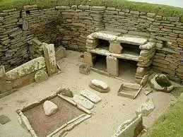
Roundhouses were particularly characteristic of Iron Age northern Britain. Their circular plans may have had practical and social advantages. Thick walls could support substantial roofs, while the central hearth provided heat, light, and a location for cooking.

Interior organization probably reflected household activities. Areas around the central hearth may have been used for cooking and social interaction, while peripheral spaces could have accommodated storage, sleeping areas, tools, and craft activities.

Some buildings were rebuilt repeatedly. This is archaeologically significant because rebuilding indicates that people remained attached to particular locations. Rather than abandoning a structure immediately when it deteriorated, communities sometimes modified and reconstructed it.

Food and Daily Life

Life on an Iron Age farm was closely connected to the seasonal rhythm of agriculture.

Spring brought preparation of fields and livestock. Summer involved cultivation, animal care, and preparation for the harvest. Autumn was particularly demanding because cereals needed to be harvested, processed, and stored. Winter required communities to rely heavily on preserved food and stored grain.

Food preparation would have involved grinding cereals into flour or meal, cooking porridge-like foods, baking simple breads, and preparing meat. Meat could be roasted, boiled, or otherwise processed. Dairy products may also have been important.

Marine resources supplemented agricultural production. Fish, shellfish, and seabirds could provide additional protein, especially when agricultural supplies were limited.

Tools and Technology

The designation “Iron Age” refers to the increasing importance of iron technology, but iron was not necessarily the only material used for tools.

Stone remained important. Bone and antler were also useful for smaller implements. Iron, however, offered significant advantages for agricultural and woodworking tools.

Iron objects could include knives, awls, sickles, and other implements. Metalworking itself required specialist knowledge, including the ability to heat and shape metal. The presence of ironworking evidence can therefore reveal another dimension of settlement activity.

Social Organization

The farm should not be imagined as an isolated household disconnected from the wider world.

Iron Age Orkney contained communities with varying degrees of social hierarchy. Brochs and monumental settlements demonstrate that some groups possessed the resources and organizational capacity necessary for substantial construction projects.

Ordinary farms existed within this broader social system. Their inhabitants may have participated in exchange networks, kinship relationships, political alliances, and seasonal gatherings.

Livestock could have played an important role in social relationships. Animals were not simply food; they could represent wealth and could be exchanged through marriage arrangements, alliances, tribute, or other forms of social interaction.

Connections Across the Orkney Islands

Stronsay was part of an interconnected island world.

People could travel between islands using boats, allowing the movement of people, livestock, raw materials, and manufactured goods. Although modern observers sometimes imagine prehistoric island communities as isolated, maritime environments could actually facilitate communication.

Orkney's location also placed it within wider networks connecting northern Scotland with other parts of Britain and, eventually, the North Atlantic.

This maritime connectivity helps explain why archaeological traditions across Orkney share similarities while also displaying local variations.

Archaeological Importance

Iron Age farms are especially valuable because monumental sites can sometimes distort our understanding of prehistoric society. Brochs and large ceremonial monuments attract attention because they are visually spectacular, but ordinary settlements reveal how most people may actually have lived.

A farm settlement can preserve evidence about diet, agriculture, household organization, technology, and environmental adaptation.

Archaeologists can examine animal bones to reconstruct livestock practices, charred seeds to identify cultivated crops, pottery to understand cooking and storage, and microscopic residues to investigate food processing.

Even seemingly insignificant fragments can contribute to a larger reconstruction of everyday life.

The Environmental Dimension

The Iron Age inhabitants of Stronsay were active participants in their environment.

Agriculture altered vegetation patterns, while livestock grazing affected grasslands and soils. Woodland resources, where available, could provide fuel and construction materials. Coastal environments supplied marine foods and other resources.

Environmental archaeology can therefore reveal how human activity changed the landscape over centuries.

At the same time, island communities were vulnerable to environmental fluctuations. Storms, harsh winters, crop failures, and changes in marine conditions could influence survival strategies.

The ability to diversify food production was therefore an important component of resilience.

Why Stronsay's Iron Age Farm Matters

The importance of Stronsay's Iron Age settlement lies not simply in its age but in what it represents.

It demonstrates the persistence of agricultural life within a landscape that had already been occupied for thousands of years. It also contributes to a broader understanding of how communities adapted to the distinctive conditions of the Orkney Islands.

Unlike a famous royal monument, an Iron Age farm speaks primarily about ordinary people: farmers, craftspeople, children, elders, and families whose names have disappeared but whose activities remain visible through archaeological evidence.

Conclusion

Stronsay's Iron Age farm settlement represents an important part of Orkney's prehistoric heritage. Its evidence illustrates a society based on agriculture, livestock management, maritime resources, household production, and strong connections with neighboring communities.

The settlement reminds us that ancient landscapes were not dominated solely by monumental structures. Behind every broch, cairn, or ceremonial site were communities that cultivated fields, raised animals, prepared food, repaired tools, raised children, and adapted to the changing environment.

Through archaeology, these ordinary activities become evidence for reconstructing an extraordinary past.

Dunadd Fort: Argyll's Inauguration Rock Carvings

September 9, 2026

Dunadd Fort is one of the most important archaeological sites associated with the emergence of the early medieval Gaelic kingdom of Dál Riata in western Scotland. Rising dramatically above the flat expanse of Moine Mhòr, or the “Great Moss,” in Kilmartin Glen, Argyll, Dunadd was more than a defensive hillfort. It appears to have functioned as a major political and ceremonial center between approximately the sixth and eighth centuries CE.

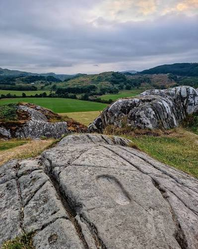
What makes Dunadd particularly remarkable is the survival of unusual carvings on the rock itself, including human footprints, a boar, an ogham inscription, and other markings. The footprints have often been interpreted as possible evidence for royal inauguration ceremonies, although archaeologists appropriately treat this interpretation as a hypothesis rather than an absolute certainty. Historic Environment Scotland describes Dunadd as a royal power center of the Gaelic kings from approximately AD 500 to AD 800.

A Strategic Hill in Argyll

Dunadd rises from the Kilmartin Glen landscape on a prominent rocky outcrop. Its position was strategically valuable because the surrounding landscape included waterways, fertile areas, routes through western Scotland, and access toward the sea.

The fort could therefore serve several purposes simultaneously:

  • defense;

  • administration;

  • elite residence;

  • craft production;

  • ceremonial activity;

  • and political display.

Archaeological discoveries demonstrate that the site was connected to long-distance exchange. Imported pottery from Gaul and Germanic glass vessels have been identified, while evidence for fine metalworking demonstrates that Dunadd participated in sophisticated craft production.

Dunadd and Dál Riata

Dál Riata was an early Gaelic kingdom whose territories included parts of western Scotland and northeastern Ireland.

Dunadd is particularly important because it appears to have been one of the kingdom's principal political centers.

Historic Environment Scotland notes that the site was already a major power center by the time it was mentioned in AD 683. It may also have been associated with traditions concerning St Columba and the wider networks of the early Christian Gaelic world.

The Mysterious Footprints

The most famous features at Dunadd are the carved human footprints.

The footprints are cut into the rock and are large enough to accommodate a human foot.

Their purpose remains uncertain.

One influential interpretation is that they formed part of a royal inauguration ritual.

In such a ceremony, a new ruler may have symbolically stood upon the footprint, demonstrating his relationship with the territory over which he would rule.

This interpretation fits broader traditions in which rulers were ceremonially connected to the land.

However, archaeology cannot prove every detail of the ceremony. The footprints may have had another symbolic or ritual function.

The Boar Carving

Another important carving is the image of a boar.

Boars held significant symbolic associations in Iron Age and early medieval Celtic cultures.

They could represent:

  • strength;

  • courage;

  • martial power;

  • elite identity;

  • and hunting.

The presence of a boar at a major royal center may therefore have carried ideological significance.

The Ogham Inscription

Dunadd also contains an ogham inscription.

Ogham was an early medieval writing system primarily associated with Ireland and the western Celtic world.

Its presence provides important evidence for literacy and cultural connections between western Scotland and Ireland.

The inscription is particularly significant because it demonstrates that Dunadd's occupants participated in the intellectual and cultural networks of the early medieval Gaelic world.

Christianity and the Royal Center

Evidence from Dunadd suggests that Christianity became part of the site's cultural environment.

Archaeological finds have provided indications of Christian activity and literacy.

This is important because the period between the sixth and eighth centuries was one of significant religious transformation in Scotland.

Christianity did not simply replace existing traditions overnight. Instead, religious change unfolded through complex interactions among local communities, elite institutions, monasteries, and political rulers.

Dunadd as a Symbol of Kingship

Dunadd's importance therefore extended beyond military defense.

The site embodied political authority.

A ruler who controlled Dunadd could potentially demonstrate control over:

  • territory;

  • trade;

  • military resources;

  • skilled craftsmen;

  • religious connections;

  • and royal ceremony.

The rock carvings were part of this symbolic landscape.

Archaeological Significance

Excavations have revealed evidence of occupation, craft production, imported goods, fortification, and elite activity.

The archaeological record demonstrates that Dunadd was connected to a wider world rather than functioning as an isolated hillfort.

Its significance lies in its ability to illuminate the formation of early medieval political society in Scotland.

Conclusion

Dunadd Fort: Argyll's Inauguration Rock Carvings represents one of Scotland's most important archaeological windows into early medieval kingship.

Its footprints, boar carving, ogham inscription, fortifications, imported objects, and craft evidence collectively suggest a sophisticated political center.

The site cannot tell us exactly how every inauguration ceremony occurred, but its archaeological remains strongly demonstrate that Dunadd was a place where political authority, ritual symbolism, craftsmanship, literacy, and territorial power came together.

Kilmartin Glen: Argyll's 5,000-Year Megalithic Landscape

September 9, 2026

Kilmartin Glen in Argyll contains one of the most remarkable concentrations of prehistoric monuments in Scotland. Spread across a relatively compact landscape are chambered cairns, stone circles, standing stones, burial monuments, carved rocks, and later archaeological remains.

The importance of Kilmartin Glen does not come from a single spectacular monument. Instead, its significance lies in the relationship among dozens of monuments arranged across the landscape.

The monuments demonstrate that prehistoric communities were deliberately organizing space, memory, burial, ritual, and movement thousands of years ago.

A Landscape of Monuments

Kilmartin Glen contains an extraordinary concentration of prehistoric archaeological features.

These include:

  • chambered cairns;

  • Bronze Age burial cairns;

  • stone circles;

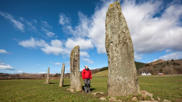
  • standing stones;

  • stone alignments;

  • rock art;

  • and later settlements.

Historic Environment Scotland describes the glen as one of Scotland's richest prehistoric landscapes, with an especially dense concentration of carved stone surfaces and Neolithic and Bronze Age monuments.

The Linear Cemetery

One of the most striking features is the line of burial cairns extending approximately two kilometers along the valley.

The group includes:

  • Glebe Cairn;

  • Nether Largie North Cairn;

  • Nether Largie Mid Cairn;

  • Nether Largie South Cairn;

  • and Ri Cruin Cairn.

These monuments belong broadly to the Late Neolithic and Bronze Age periods, with dates extending roughly from 5,000 to 3,500 years ago.

Nether Largie South

Nether Largie South is particularly important because it is older than the other cairns in the linear cemetery.

Its original form was a Clyde-type chambered cairn dating to the Neolithic period.

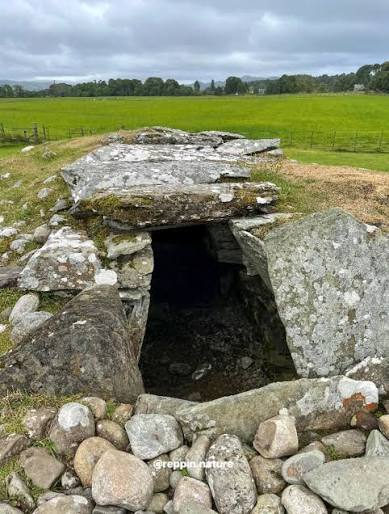
The central chamber was divided into compartments and was probably used for multiple burials.

Later, approximately 4,000 years ago, the monument was enlarged into a large round cairn incorporating additional Bronze Age burial cists.

This transformation demonstrates that monuments could remain meaningful for centuries.

Ritual Continuity

One of the most important lessons from Kilmartin Glen is that prehistoric monuments were not necessarily abandoned after their initial construction.

Later communities sometimes modified, reused, expanded, or built new monuments near earlier ones.

This suggests that prehistoric people were interacting with an inherited landscape.

Ancient monuments could therefore function as places of:

  • memory;

  • ancestry;

  • territorial identity;

  • ceremony;

  • and social authority.

Rock Art

Kilmartin Glen is also famous for its prehistoric rock art.

Many carved rocks contain:

  • cup marks;

  • cup-and-ring motifs;

  • grooves;

  • spirals;

  • and other abstract designs.

Their precise meanings remain uncertain.

Archaeologists have proposed that such carvings may have had ritual, symbolic, territorial, or commemorative functions.

Because no written explanations survive, interpretations must remain cautious.

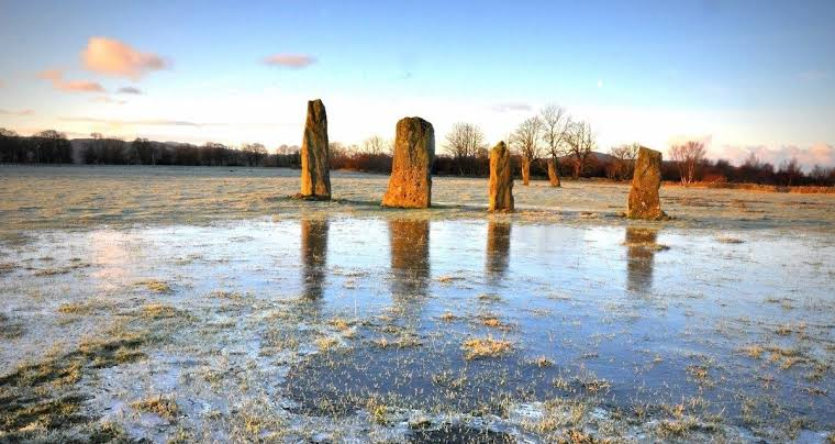
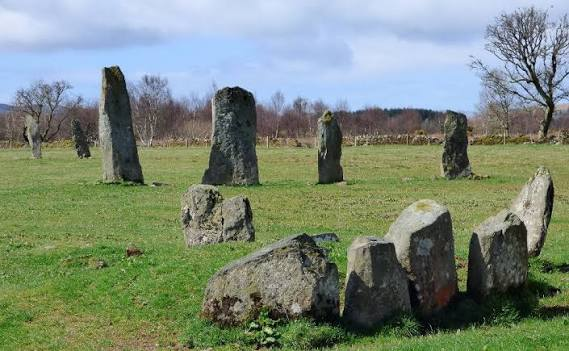
Standing Stones

Standing stones and alignments add another dimension to the landscape.

Their deliberate placement suggests that prehistoric communities were concerned with the organization of space.

Some monuments are positioned so that they are visually connected to others.

This intervisibility is one of the most important characteristics of Kilmartin Glen.

The Importance of Visibility

The monuments were not necessarily designed to be viewed individually.

Instead, many formed part of a broader visual landscape.

A person moving through the glen could encounter:

  • standing stones;

  • cairns;

  • carved rocks;

  • hills;

  • and other monuments.

This could create a powerful ceremonial experience.

Social Organization

Building large monuments required considerable labor.

Workers had to:

  1. quarry or collect stone;

  2. transport heavy materials;

  3. prepare the site;

  4. construct chambers or walls;

  5. organize burials;

  6. and maintain the monuments.

Such projects imply substantial cooperation.

They therefore provide evidence for organized communities capable of coordinating labor over long periods.

Burial and Social Status

Some later Bronze Age burials appear to have been associated with high-status individuals.

For example, rare axe-head carvings at Nether Largie Mid and North have been interpreted in connection with elite status because axes could represent wealth and prestige.

Conclusion

Kilmartin Glen: Argyll's 5,000-Year Megalithic Landscape is best understood not as one archaeological monument but as a carefully structured prehistoric environment.

Its cairns, stone circles, standing stones, and rock art reveal how ancient communities used the landscape to express beliefs about death, ancestry, identity, and social organization.

The extraordinary survival of these monuments makes Kilmartin Glen one of Scotland's most valuable archa

Nether Largie: Argyll's Clyde Tomb Alignment

September 9, 2026

Nether Largie forms one of the most important components of the prehistoric ceremonial landscape of Kilmartin Glen.

Rather than representing a single monument, the Nether Largie complex consists of several burial cairns positioned along the valley floor. Together they demonstrate how prehistoric communities repeatedly returned to the same landscape for funerary and ritual purposes.

The Linear Cemetery

The cairns of Kilmartin Glen form a remarkable north-south alignment.

The monuments are visually connected with one another and with other ritual features of the valley.

This arrangement suggests that location itself was an important part of prehistoric ceremonial activity.

Nether Largie South

Nether Largie South is particularly significant because it originated as a Clyde-type chambered cairn.

The monument was constructed more than 5,000 years ago.

Its central chamber was divided into compartments and probably accommodated multiple burials over an extended period.

Communal Burial

Unlike a modern individual tomb, Neolithic chambered cairns could function as communal burial monuments.

Bodies were placed inside over time.

As additional burials occurred, earlier remains could be rearranged.

Archaeological evidence from comparable monuments suggests that bones could be organized into groups, such as skulls and long bones.

Transformation During the Bronze Age

Nether Largie South was later modified.

The earlier chambered cairn was expanded into a large round cairn.

Two additional cists were inserted into the monument.

This demonstrates that the site remained meaningful long after its original construction.

Nether Largie Mid

Nether Largie Mid belongs to the later Bronze Age phase of the cemetery.

Two burial cists were discovered during excavation.

One contained unusual carved motifs, including cup-and-ring markings and representations of axe-heads.

These carvings are significant because axe imagery is relatively rare in Scotland.

Nether Largie North

Nether Largie North also contains remarkable carvings.

Its central cist capstone features approximately forty cup-and-ring marks as well as two pecked axe-head representations.

The possibility that the capstone itself had an earlier history of use is particularly intriguing.

The Meaning of the Alignment

Why were these cairns placed in a line?

No definitive answer exists.

Possible interpretations include:

  • ceremonial movement;

  • ancestral commemoration;

  • territorial marking;

  • astronomical observation;

  • or the deliberate creation of a sacred landscape.

The strongest archaeological conclusion is that the monuments were not randomly distributed.

Landscape and Memory

Prehistoric societies did not necessarily separate the past from the present as sharply as modern societies often do.

An ancient burial monument could remain an active symbol for generations.

New communities could build beside older monuments, creating a layered landscape in which different periods remained physically connected.

Conclusion

Nether Largie: Argyll's Clyde Tomb Alignment provides extraordinary evidence for long-term prehistoric engagement with death, ancestry, and landscape.

The monuments reveal not only how people buried their dead but also how communities organized sacred places across generations.

Their alignment within Kilmartin Glen makes them an essential part of Scotland's prehistoric ceremonial geograph

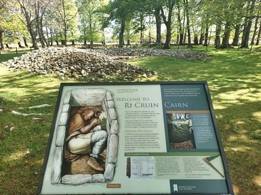
Ri Cruin: Argyll's Bronze Age Cairn Circle

September 9, 2026

Ri Cruin Cairn occupies the southern end of Kilmartin Glen's remarkable prehistoric linear cemetery.

The monument forms part of a landscape in which burial cairns, standing stones, stone circles, and carved rocks were arranged in close proximity.

Its Bronze Age construction provides evidence for changing burial customs and social practices in prehistoric Argyll.

A Monument Within a Larger Landscape

Ri Cruin is not an isolated cairn.

It belongs to the broader ceremonial landscape of Kilmartin Glen, where several large burial monuments were positioned along the valley.

The placement of Ri Cruin at the southern end of the cemetery contributed to the visual and spatial organization of the landscape.

Bronze Age Burial

Ri Cruin belongs primarily to the Bronze Age phase of Kilmartin Glen's prehistoric cemetery.

Bronze Age burial practices differed from earlier Neolithic traditions.

Instead of large communal chambered tombs, communities increasingly used individual cists and cairns.

This shift may reflect changing ideas about:

  • individual identity;

  • ancestry;

  • social status;

  • and leadership.

Cairns as Monuments

A cairn is essentially a mound constructed from stones.

Building one required the gathering, transporting, and carefully positioning of large quantities of material.

A monumental cairn therefore represented a significant investment of labor.

Elite Burials

Bronze Age burial monuments sometimes contained objects associated with status.

These could include:

  • bronze weapons;

  • tools;

  • pottery;

  • ornaments;

  • and other valuable objects.

Such objects can provide clues about social hierarchy.

Kilmartin Glen's Burial Tradition

The repeated construction of burial monuments in Kilmartin Glen indicates that the area retained religious importance for generations.

Ri Cruin therefore forms part of a long-term tradition of commemorating the dead within a highly visible landscape.

The Importance of Visibility

Many of Kilmartin Glen's monuments can be seen from one another.

This suggests that prehistoric people may have understood the valley as a connected ceremonial environment.

The monuments could have served as physical reminders of ancestors and earlier communities.

Archaeological Interpretation

Archaeologists must distinguish between what is directly demonstrated by evidence and what is reconstructed through interpretation.

We can establish the monument's prehistoric date and relationship to the wider cemetery.

However, the exact rituals performed there remain unknown.

Conclusion

Ri Cruin: Argyll's Bronze Age Cairn Circle demonstrates the continuing importance of burial and monumental construction during prehistoric Scotland's Bronze Age.

Its position within Kilmartin Glen's linear cemetery reveals that prehistoric communities were deliberately creating relationships among tombs, stones, landscapes, and ance

Barnaluasgan: Argyll's Standing Stones

September 9, 2026

Standing stones are among the most recognizable archaeological remains of prehistoric Britain.

Barnaluasgan belongs to the broader tradition of deliberately positioned stones found throughout Argyll and particularly around the prehistoric landscapes of Kilmartin Glen.

These monuments demonstrate that prehistoric communities were capable of transforming natural landscapes into places of ceremony and memory.

What Are Standing Stones?

Standing stones are large stones deliberately erected vertically.

They vary enormously in:

  • size;

  • shape;

  • arrangement;

  • date;

  • and purpose.

Some stand alone, while others occur in pairs, rows, circles, or alignments.

Why Were They Built?

The exact purpose of individual standing stones is rarely known.

Possible functions include:

  • ceremonial activity;

  • territorial marking;

  • memorialization;

  • astronomical observation;

  • route marking;

  • or participation in rituals.

It is important not to assume that every standing stone served the same function.

The Argyll Landscape

Argyll contains numerous prehistoric monuments.

The region's mountains, valleys, lochs, and islands created a highly distinctive natural environment.

Standing stones could provide fixed reference points within this landscape.

Relationship With Burial Monuments

In Kilmartin Glen, standing stones frequently occur near burial cairns and other ritual monuments.

This proximity suggests that these features may have been conceptually connected.

Moving Megaliths

Moving large stones required substantial organization.

Depending on their size and distance, prehistoric builders may have used:

  • wooden sledges;

  • ropes;

  • rollers;

  • manpower;

  • and prepared tracks.

Such projects demonstrate collective labor and social coordination.

Symbolism

Stone possesses qualities that make it particularly appropriate for monuments.

It is:

  • durable;

  • visible;

  • difficult to move;

  • and capable of surviving for generations.

A standing stone could therefore become a physical symbol of permanence.

Conclusion

Barnaluasgan: Argyll's Standing Stones illustrates how prehistoric communities transformed natural stone into enduring cultural landmarks.

Although the precise meaning of the stones remains uncertain, their survival demonstrates that prehistoric societies deliberately shaped landscapes to express social and ritual ideas.

Ballymeanoch: Argyll's Kerbed Cairn

September 9, 2026

Ballymeanoch is part of the extraordinary prehistoric landscape surrounding Kilmartin Glen.

Its archaeological significance comes from its relationship to nearby standing stones, burial monuments, and other prehistoric remains.

The site illustrates how prehistoric communities used stone not simply as a building material but as a means of organizing ritual space.

The Meaning of a Kerbed Cairn

A kerbed cairn is a burial monument in which the outer edge of the stone mound is deliberately defined by a kerb or boundary of stones.

This feature gives the monument a clearly structured perimeter.

Such boundaries may have helped distinguish the sacred burial space from its surroundings.

The Kilmartin Landscape

Ballymeanoch exists within one of Scotland's richest concentrations of prehistoric monuments.

The surrounding landscape includes:

  • standing stones;

  • cairns;

  • stone alignments;

  • rock art;

  • and ceremonial monuments.

This concentration indicates that the area was repeatedly used for ritual purposes.

Stone and Ceremony

The movement and placement of stones required organized labor.

Even relatively modest monuments could involve considerable effort.

Large stones had to be selected, transported, positioned, and stabilized.

Burial Practices

Prehistoric cairns were frequently associated with funerary activity.

However, not every monument necessarily served a single function throughout its history.

Sites could be altered, reused, or incorporated into later ceremonial landscapes.

The Importance of Context

The archaeological importance of Ballymeanoch becomes clearer when the monument is studied together with neighboring features.

Rather than asking only “What was this cairn used for?”, archaeologists can ask:

  • Why was it built here?

  • What monuments could people see from it?

  • How did people move through the landscape?

  • Was it associated with particular communities or ancestors?

Conclusion

Ballymeanoch: Argyll's Kerbed Cairn represents the complexity of prehistoric monument-building in Kilmartin Glen.

Its value lies not only in its physical remains but also in its relationship to the surrounding ceremonial landscape.

The monument provides another piece of evidence for a prehistoric society that invested substantial effort in creating meaningful places connected to death, memory, and ritual.

Vinquoy Hill: Eday's Chambered Cairn

September 9, 2026

Vinquoy Hill is home to one of Eday's important prehistoric chambered cairns.

The monument contributes to the extraordinary concentration of Neolithic burial architecture found throughout Orkney.

The Chambered Cairn

A chambered cairn was a large stone-built burial monument.

Vinquoy Hill's architecture reflects the wider tradition of constructing enclosed chambers beneath substantial stone mounds.

The Passage

A passage provided access to the internal chamber.

Such passages could create a controlled transition between the outside world and the interior.

This architectural distinction may have had symbolic significance.

Collective Burial

The monument could accommodate multiple human remains.

The accumulation of remains over generations suggests that these monuments were important repositories of ancestral memory.

Monumental Construction

The builders had to coordinate large quantities of stone.

They needed to understand:

  • structural stability;

  • weight distribution;

  • roofing;

  • and drainage.

The survival of these monuments demonstrates the effectiveness of their construction methods.

The Hilltop Location

The position on Vinquoy Hill is significant.

Elevated monuments could be visible from considerable distances.

They could therefore function as territorial landmarks as well as funerary structures.

Eday's Archaeological Richness

Eday contains numerous prehistoric monuments.

This concentration suggests that the island was an important component of the wider ceremonial and agricultural system of Neolithic Orkney.

Ancestry and Identity

A monumental tomb could reinforce a community's connection with its ancestors.

The monument effectively transformed memory into architecture.

Generations could recognize the same structure as a landmark connected with their predecessors.

Conclusion

Vinquoy Hill: Eday's Chambered Cairn demonstrates the sophisticated architectural and social traditions of Neolithic Orkney.

The monument's construction, elevated location, and funerary function reveal a society in which ancestry, community identity, and landscape were closely interconnected.

Pollachlean: Argyll's Early Christian Site

September 9, 2026

Pollachlean belongs to the broader archaeological record of early Christian activity in Argyll, a region that played an important role in the development of Christianity in western Scotland.

The early medieval period was a time of significant cultural transformation, during which Christianity became increasingly integrated into political, social, and artistic life.

Christianity in Western Scotland

Christianity reached western Scotland through several interconnected routes.

Irish missionary traditions were particularly important.

The foundation of Iona by St Columba in the sixth century became one of the best-known centers of Christianity in the region.

Local Christian Sites

Early Christian sites in Argyll often include relatively modest remains.

They may consist of:

  • chapels;

  • burial grounds;

  • crosses;

  • carved stones;

  • grave markers;

  • or small monastic settlements.

Such sites demonstrate that Christianity was not confined to major monasteries.

The Landscape of Worship

Early Christian communities often established religious places within existing landscapes.

Some sacred locations may have continued traditions associated with earlier communities.

This created complex layers of cultural memory.

Burial

Christian burial practices are particularly important archaeologically.

Graveyards can reveal:

  • population patterns;

  • social organization;

  • diet;

  • disease;

  • mobility;

  • and changing religious traditions.

Early Medieval Argyll

Argyll was closely connected to the kingdom of Dál Riata.

The region's maritime geography connected communities in western Scotland with Ireland and other parts of the Irish Sea world.

Christianity developed within this interconnected environment.

Material Culture

Early Christian archaeological sites may contain:

  • carved stones;

  • crosses;

  • metal objects;

  • pottery;

  • and ecclesiastical structures.

These objects provide evidence for artistic and religious exchange.

Conclusion

Pollachlean: Argyll's Early Christian Site forms part of the wider story of Christianity's development in western Scotland.

Its significance lies in demonstrating how religious traditions became embedded within local communities and landscapes during the formative centuries of medieval Scotland.

Kilchoan: Argyll's Medieval Chapel

September 9, 2026

Kilchoan represents the type of small religious site that helps archaeologists reconstruct medieval life beyond Scotland's major monasteries and cathedrals.

Medieval chapels served communities that could be geographically isolated yet deeply connected to wider religious traditions.

Medieval Chapels in Scotland

A medieval chapel was generally smaller than a major parish church.

It could serve:

  • local communities;

  • estates;

  • pilgrimage routes;

  • burial grounds;

  • or remote settlements.

Religious Life in Argyll

Argyll's geography strongly influenced medieval religious organization.

The region contained:

  • islands;

  • sea lochs;

  • mountains;

  • peninsulas;

  • and scattered settlements.

Travel by sea could sometimes be easier than travel over land.

The Maritime Church

Religious communities in western Scotland were connected through maritime routes.

Monks, clergy, travelers, and pilgrims could move between islands and mainland communities by boat.

Architecture

Medieval chapels were often relatively simple structures.

Common architectural elements included:

  • stone walls;

  • narrow doorways;

  • small windows;

  • a simple rectangular plan;

  • and nearby burial grounds.

Even modest buildings could possess considerable spiritual importance.

Burial and Memory

Chapels were frequently associated with cemeteries.

Burial around a sacred building connected the living community with its ancestors.

Medieval Argyll and Clan Society

Religious sites could also become associated with local elites and clans.

Patronage of churches and chapels could reinforce political authority.

Archaeological Evidence

Even when only ruins survive, archaeologists can examine:

  • wall construction;

  • foundations;

  • graves;

  • carved stones;

  • pottery;

  • and landscape relationships.

These remains help reconstruct the site's history.

Conclusion

Kilchoan: Argyll's Medieval Chapel illustrates the importance of small religious buildings in medieval Scotland.

Such chapels remind us that medieval Christianity was experienced not only in famous monasteries but also in remote communities where worship, burial, identity, and local social life were closely intertwined.

Castle Tioram: Lochaber’s Jacobite Stronghold

September 9, 2026

Castle Tioram is one of the most dramatic medieval fortifications in the western Highlands.

Situated on a tidal island at the entrance to Loch Moidart, the castle was associated with the Clan MacDonald of Clanranald and became closely connected with the political struggles of the seventeenth and eighteenth centuries.

Its ruined walls preserve evidence of a turbulent period in Highland history.

The Island Fortress

Castle Tioram occupies a naturally defensive location.

The surrounding waters provided protection from land-based attack, while the castle's position allowed its occupants to control access through the surrounding sea routes.

Clanranald

The castle became an important stronghold of the MacDonalds of Clanranald.

Clanranald was one of the major branches of the powerful MacDonald political network in the western Highlands and Islands.

The Lordship of the Isles

The castle's historical setting cannot be separated from the wider history of the Lordship of the Isles.

The MacDonalds controlled extensive territories across the western seaboard.

Their power depended heavily on:

  • land;

  • maritime transport;

  • alliances;

  • kinship;

  • and armed retainers.

The Jacobite Era

Castle Tioram became particularly associated with the Jacobite cause.

During the early eighteenth century, political divisions between supporters of the Stuart monarchy and the Hanoverian government deeply affected Highland society.

The castle was destroyed or deliberately rendered unusable during the 1715 Jacobite Rising. The destruction reflects the government's concern about fortified Highland strongholds.

The 1745 Rising

The Jacobite Rising of 1745 further transformed the region.

Prince Charles Edward Stuart's campaign attracted support from numerous Highland clans.

The failure of the rising eventually resulted in severe political consequences for Jacobite families.

Architecture

Castle Tioram consists primarily of a substantial stone enclosure and tower structures.

Its walls adapted to the island's natural shape.

The defensive position was particularly advantageous because attackers approaching by land had limited options.

A Maritime Stronghold

Unlike many mainland castles, Castle Tioram's environment was fundamentally maritime.

Boats could transport:

  • people;

  • food;

  • weapons;

  • messages;

  • and supplies.

The sea was therefore both a defensive barrier and a transportation network.

Archaeological Importance

The ruined castle preserves evidence of centuries of occupation and adaptation.

Its significance lies not only in its architecture but in its association with clan politics and the changing relationship between Highland communities and the Scottish state.

Conclusion

Castle Tioram: Lochaber’s Jacobite Stronghold is a powerful symbol of Highland political history.

Its island location, medieval architecture, MacDonald connections, and association with the Jacobite era demonstrate how castles functioned as both military structures and expressions of political authority.

← Newer Posts Older Posts →
Featured
images (85).jpeg
September 14, 2026
Birka: Sweden's Viking Trading Island
September 14, 2026
Read more →
September 14, 2026
images (84).jpeg
September 14, 2026
Uppåkra: Sweden's Iron Age Power Center
September 14, 2026
Read more →
September 14, 2026
images (83).jpeg
September 14, 2026
Tissø: Denmark's Viking Age Lake Village
September 14, 2026
Read more →
September 14, 2026
images (82).jpeg
September 14, 2026
Lejre: Denmark's Royal Iron Age Hal
September 14, 2026
Read more →
September 14, 2026
images (81).jpeg
September 14, 2026
Gudme: Denmark's Iron Age Gold Hoard Site
September 14, 2026
Read more →
September 14, 2026
images (80).jpeg
September 14, 2026
Nonnebakken: Odense's Viking Fort Remains
September 14, 2026
Read more →
September 14, 2026
read more

Powered by The archaeologist