• MAIN PAGE
  • LATEST NEWS
    • Lost Cities
    • Archaeology's Greatest Finds
    • Underwater Discoveries
    • Greatest Inventions
    • Studies
    • Blog
  • PHILOSOPHY
  • HISTORY
  • RELIGIONS
    • Africa
    • Anatolia
    • Arabian Peninsula
    • Balkan Region
    • China - East Asia
    • Europe
    • Eurasian Steppe
    • Levant
    • Mesopotamia
    • Oceania - SE Asia
    • Pre-Columbian Civilizations of America
    • Iranian Plateau - Central Asia
    • Indus Valley - South Asia
    • Japan
    • The Archaeologist Editor Group
    • Scientific Studies
    • Aegean Prehistory
    • Historical Period
    • Byzantine Middle Ages
    • Predynastic Period
    • Dynastic Period
    • Greco-Roman Egypt
  • Rome
  • PALEONTOLOGY
  • About us
Menu

The Archaeologist

  • MAIN PAGE
  • LATEST NEWS
  • DISCOVERIES
    • Lost Cities
    • Archaeology's Greatest Finds
    • Underwater Discoveries
    • Greatest Inventions
    • Studies
    • Blog
  • PHILOSOPHY
  • HISTORY
  • RELIGIONS
  • World Civilizations
    • Africa
    • Anatolia
    • Arabian Peninsula
    • Balkan Region
    • China - East Asia
    • Europe
    • Eurasian Steppe
    • Levant
    • Mesopotamia
    • Oceania - SE Asia
    • Pre-Columbian Civilizations of America
    • Iranian Plateau - Central Asia
    • Indus Valley - South Asia
    • Japan
    • The Archaeologist Editor Group
    • Scientific Studies
  • GREECE
    • Aegean Prehistory
    • Historical Period
    • Byzantine Middle Ages
  • Egypt
    • Predynastic Period
    • Dynastic Period
    • Greco-Roman Egypt
  • Rome
  • PALEONTOLOGY
  • About us
No results found

Dugway Proving Ground: Utah's WWII Relics

September 27, 2026

Introduction

Dugway Proving Ground occupies an enormous and highly restricted landscape in western Utah. Established during World War II, it became an important U.S. military testing facility in the development and evaluation of chemical, biological, incendiary, and other weapons and defensive technologies.

The site is historically significant because its physical remains preserve evidence of a less visible side of World War II: the enormous expansion of military research, testing, training, and logistical infrastructure required to fight a global industrial war.

The U.S. Army states that Dugway was established in 1942 after the federal government withdrew more than 126,000 acres for War Department use, with testing beginning that same year.

Why Utah?

The location of Dugway was deliberate.

Military testing required large areas where dangerous experiments could be conducted away from major population centers.

Western Utah provided:

  • enormous open spaces;

  • low population density;

  • varied desert terrain;

  • controlled access;

  • proximity to existing military infrastructure.

The desert therefore became a military laboratory.

Establishment in 1942

Dugway Proving Ground was officially activated on March 1, 1942.

The initial mission involved testing chemical warfare defenses and weapons.

Testing began during the first year of operation.

The urgency reflected the global circumstances of World War II.

The United States feared chemical warfare and needed to understand both offensive weapons and defensive measures.

Chemical Warfare

Chemical warfare research involved studying substances capable of incapacitating or killing personnel.

Testing required controlled environments, specialized equipment, protective measures, and carefully monitored experiments.

The history is therefore part of the development of modern military science.

Biological Warfare

Dugway's responsibilities expanded.

In 1943, biological warfare testing facilities were established at the installation.

The existence of these facilities demonstrates the breadth of wartime military research.

Biological weapons posed different scientific and logistical problems from chemical weapons.

They required different methods of containment, testing, dissemination, and detection.

Incendiary Testing

Dugway also tested incendiary bombs.

Such weapons were particularly important in the context of aerial warfare.

Testing helped military planners understand how weapons behaved under different conditions.

The Landscape as Laboratory

The desert environment itself became part of the testing infrastructure.

Open areas could be divided into test ranges.

Observation stations could be positioned at controlled distances.

Roads and communications systems connected test areas to administrative facilities.

Buildings housed laboratories, personnel, equipment, and storage.

The entire landscape functioned as a military-industrial system.

WWII Relics

Historic military remains can include:

  • barracks;

  • administrative buildings;

  • test structures;

  • roads;

  • observation facilities;

  • foundations;

  • storage areas;

  • communication infrastructure.

Some evidence is highly visible.

Other remains are subtle.

Because military facilities were frequently designed for secrecy, documentation and archaeological interpretation are particularly important.

Postwar Development

Dugway did not simply disappear after World War II.

The proving ground continued to evolve.

After the war, the facility experienced periods of reduced activity and later reactivation.

During the Cold War, its mission expanded into new areas of military testing.

Ethical and Environmental Questions

Military testing creates difficult historical questions.

Weapons testing can contaminate environments.

Some materials can remain hazardous decades later.

Historical preservation must therefore be balanced against public safety.

Restricted access can also limit archaeological investigation.

Interpreting a Secret Landscape

One of the most interesting aspects of Dugway's history is secrecy.

During wartime, information was intentionally limited.

Workers might understand only part of a project's purpose.

Official records could remain classified for years.

Archaeology and declassified documents can therefore help reconstruct activities that were once hidden.

Conclusion

Dugway Proving Ground represents the transformation of the western desert into a military testing landscape during World War II.

Its surviving infrastructure reflects the enormous scale of wartime scientific research.

The site also raises important questions about secrecy, environmental consequences, technological development, and the responsibilities involved in preserving military heritage.


Wendover Airfield: Utah's Enola Gay Base

September 27, 2026

Introduction

Wendover Airfield is one of the most significant World War II aviation sites in Utah.

Located in the remote western part of the state, the airfield began as a training facility for heavy bomber crews. It later became the secret training base of the 509th Composite Group, the unit associated with the atomic bombing missions against Japan in August 1945.

The National Park Service describes Wendover as an important training site for heavy bombardment crews and as the base where the 509th Composite Group trained before moving to Tinian.

Construction of the Airfield

The military began developing Wendover in the late 1930s.

The location offered extensive open space suitable for bombing and gunnery training.

The desert environment also reduced the risk of accidental damage to densely populated areas.

By 1942, training operations were well established.

Heavy Bomber Training

Wendover trained crews for some of the largest aircraft used by the United States during World War II.

Heavy bombers required specialized crews.

Pilots, navigators, bombardiers, engineers, radio operators, and gunners had to coordinate their activities.

Training emphasized precision.

The 509th Composite Group

In late 1944, Wendover became the home of the newly organized 509th Composite Group.

The unit had a highly specialized mission.

Its aircraft had to be modified to carry the enormous atomic bombs being developed through the Manhattan Project.

The group's training was conducted under extraordinary secrecy.

The Enola Gay

The B-29 known as the Enola Gay was associated with the 509th Composite Group.

The aircraft later carried the atomic bomb used against Hiroshima on August 6, 1945.

The crew had trained at Wendover before the group moved to Tinian in the Pacific.

It is therefore historically accurate to describe Wendover as the training base associated with the Enola Gay, while recognizing that the Hiroshima mission itself departed from Tinian, not Utah.

Secrecy

Security at Wendover became extremely strict.

The 509th operated as a specialized and relatively self-contained unit.

Personnel were not necessarily informed about the full purpose of their activities.

The secrecy reflected the military importance of the Manhattan Project.

Infrastructure

Wendover became a substantial military installation.

At its height, the base included hundreds of buildings, long runways, hangars, barracks, administrative facilities, maintenance areas, and specialized training infrastructure.

The scale of the installation illustrates how much physical infrastructure was required to operate heavy bomber forces.

Atomic-Bomb Training

The crews practiced specialized bombing techniques.

The B-29 had to be modified.

Bomb-loading procedures had to be developed.

Crews practiced flight patterns and release techniques.

The objective was to make an unprecedented weapon compatible with an operational aircraft.

Tinian

The 509th left Wendover for Tinian in 1945.

The Pacific base became the operational location for the atomic bombing missions.

The transition from Utah to Tinian demonstrates how Wendover functioned primarily as a training and preparation site.

Preservation

Wendover's historic buildings are valuable because they preserve the physical setting of World War II aviation.

Unlike a conventional museum display, the landscape allows visitors to understand the spatial scale of military aviation.

The National Park Service has described the surviving installation as exceptionally well preserved for a World War II Army Air Forces training base.

Historical Debate

Wendover's history cannot be separated from the broader history of nuclear warfare.

The atomic bombings of Hiroshima and Nagasaki remain major subjects of historical debate.

The airfield itself, however, can be studied without reducing its history to a single argument.

Its importance includes aviation technology, military training, secrecy, logistics, engineering, and the development of nuclear warfare.

Conclusion

Wendover Airfield preserves one of the most consequential military landscapes in Utah.

Its connection to the Enola Gay and the 509th Composite Group gives the site global historical significance.

At the same time, the airfield preserves the broader story of World War II aviation and the thousands of personnel who operated the vast infrastructure necessary to prepare for the final stages of the war.

Skull Valley: Utah's Goshute Indian Farmsteads

September 27, 2026

Introduction

Skull Valley contains a long and complicated history of Indigenous adaptation, settlement, agriculture, ranching, transportation, and federal land policy.

The Goshute people have deep historical connections to the Great Basin, including western Utah's valleys and mountain ranges. Their traditional lifeways were highly adapted to an arid environment.

Later agricultural settlements and government policies introduced new economic pressures and land-use patterns.

The Goshute Homeland

The Great Basin is one of North America's most challenging environments for agriculture.

Rainfall is limited.

Water sources are scattered.

Temperatures vary dramatically.

Goshute communities developed strategies based on hunting, gathering, seasonal movement, and intimate knowledge of local ecological resources.

Seasonal Mobility

It is important not to interpret mobility as a lack of territorial organization.

Indigenous communities could have highly structured relationships with particular places while moving between them seasonally.

Knowledge of plant communities, animal habitats, springs, and weather patterns was essential.

The Arrival of Agriculture

European-American settlement introduced different concepts of land use.

Agricultural fields required fixed locations.

Fences established property boundaries.

Livestock competed with wildlife and Indigenous resource use.

Irrigation altered water distribution.

These changes transformed the landscape.

Farmsteads

Indigenous farmsteads, where documented, are important because they demonstrate adaptation to changing economic and political conditions.

Agriculture could become a strategy for maintaining communities under new circumstances.

Growing crops required access to water and labor.

It also created opportunities for greater food security.

Government Policies

Federal policies toward Indigenous peoples frequently encouraged or imposed agricultural settlement.

The stated goal was often assimilation into Euro-American farming systems.

In practice, these policies could restrict mobility and undermine traditional economic systems.

The history of Indigenous agriculture must therefore be understood within the context of colonial pressure.

Water

Water is central to the history of Skull Valley.

Irrigation required diverting or controlling scarce water resources.

The construction of wells, ditches, canals, and reservoirs changed hydrology.

For communities dependent upon both wild and cultivated foods, such changes could have significant consequences.

Archaeological Evidence

Farmsteads can preserve:

  • field boundaries;

  • irrigation features;

  • foundations;

  • storage structures;

  • agricultural tools;

  • ceramics;

  • animal remains;

  • food remains.

These materials reveal how people adapted to changing economic systems.

Continuity

Goshute history did not end with the arrival of settlers.

Indigenous communities continued to adapt.

Some incorporated wage labor.

Others engaged in ranching or agriculture.

Families maintained cultural practices while navigating new political realities.

Historical Interpretation

Older histories sometimes presented Indigenous agriculture as evidence that Native communities were becoming "civilized" according to Euro-American standards.

Modern scholarship treats the issue differently.

Agricultural adoption can be understood as strategic adaptation rather than cultural replacement.

Conclusion

Skull Valley's farmsteads represent an important chapter in Goshute history.

They reveal how Indigenous communities adapted to new economic and political conditions while maintaining relationships with their homeland.

The landscape demonstrates that Indigenous history in Utah is not simply an ancient archaeological story.

It continues into the modern era.

Promontory Point: Utah's Land Art Installation

September 27, 2026

Introduction

Promontory Point is closely associated with the extraordinary landscape of the Great Salt Lake and the wider Promontory Peninsula. The title's reference to a "land art installation" requires an important distinction: the famous Utah earthwork Spiral Jetty is located at Rozel Point, on the northeastern shore of the Great Salt Lake, rather than at Promontory Point itself. The Utah Museum of Fine Arts identifies Rozel Point as the location of Robert Smithson's 1970 earthwork.

Promontory Point nevertheless belongs to the broader landscape through which Utah's land-art history is often understood.

The Great Salt Lake as Artistic Landscape

The Great Salt Lake has unusual geological and visual characteristics.

Salt crusts, shallow water, exposed lakebed, black volcanic rocks, distant mountains, and changing water levels create a landscape that can appear dramatically different from season to season.

These qualities attracted artists interested in landscape, scale, geological processes, and environmental change.

Robert Smithson and Land Art

In 1970, artist Robert Smithson created Spiral Jetty using basalt rocks and earth at Rozel Point.

The earthwork extends approximately 1,500 feet into the lake and forms a large counterclockwise spiral.

The work became one of the defining examples of American Land art.

Why the Site Mattered

Smithson's choice of location was connected to the landscape itself.

The north arm of the Great Salt Lake could display striking contrasts between pinkish water, white salt, and dark basalt.

The work was designed not simply to sit in the landscape but to interact with it.

Water levels could cover the structure.

Salt could accumulate on its rocks.

Drought could expose more of the earthwork.

Art and Geological Time

Land art often challenges conventional ideas about permanence.

A painting remains within a controlled frame.

A sculpture can be maintained.

An earthwork can change through erosion, weather, water, and geological processes.

Spiral Jetty is particularly suited to this concept.

Its visibility depends partly on lake levels.

The lake becomes part of the artwork.

The Great Salt Lake Environment

The lake is itself a dynamic environmental system.

Its water levels fluctuate.

Salinity changes.

Wetlands expand and contract.

Bird populations depend on ecological conditions.

An earthwork placed within this environment inevitably becomes connected to ecological processes.

Promontory Peninsula

The Promontory Peninsula contains layers of natural and human history.

Indigenous peoples used the region long before Euro-American settlement.

Railroads transformed the peninsula in the nineteenth century.

Military and industrial activities later altered portions of the landscape.

Modern land art exists within this much older historical setting.

The Importance of Correct Location

Confusing Promontory Point with Rozel Point is understandable because both are associated with the Great Salt Lake and the Promontory Peninsula.

However, historical accuracy matters.

Spiral Jetty was constructed at Rozel Point.

The Utah Geological Survey identifies the earthwork as being at Rozel Point in the north arm of the lake.

Land Art and Preservation

Preserving land art is different from preserving a conventional building.

Should an earthwork be restored when erosion changes it?

Should salt deposits be removed?

Should natural deterioration be allowed?

What happens when climate and water-level changes alter visibility?

These questions have no simple answers.

Contemporary Significance

Spiral Jetty became an important symbol of environmental art and Utah's cultural landscape.

The work is also an example of how art can transform perceptions of remote landscapes.

A location once viewed primarily through geology, transportation, and industry became an international destination for contemporary art.

Conclusion

Promontory Point belongs to the broader landscape of Utah's extraordinary relationship between environment and land art, but the most famous earthwork associated with the region—Robert Smithson's Spiral Jetty—is specifically located at Rozel Point.

That distinction makes the broader story even more interesting.

The Promontory landscape demonstrates how Indigenous history, railroad history, geology, ecology, and contemporary art can occupy the same physical region while representing dramatically different periods of human interaction with the Great Salt Lake.

Great Salt Lake Marshes: Utah's Fremont Duck Decoys

September 27, 2026

Introduction

The Great Salt Lake marshes preserve one of Utah's most remarkable archaeological environments. Wetlands around the lake supported Indigenous communities through fishing, hunting, gathering, and access to diverse plant and animal resources.

The Fremont archaeological tradition is particularly important to understanding central Utah's prehistoric inhabitants.

The term "Fremont" is a modern archaeological designation rather than the name of a historically documented Indigenous nation. Archaeologists use it to describe a distinctive archaeological complex found across much of Utah and surrounding regions.

The Natural History Museum of Utah describes Fremont lifeways as spanning approximately CE 300–1300 and involving agriculture combined with substantial hunting and gathering.

The Great Salt Lake Wetlands

Wetlands around the Great Salt Lake are extraordinarily productive environments.

Marshes provide habitat for birds, fish, insects, plants, and other organisms.

For Indigenous communities, these environments offered concentrated sources of food.

Compared with the surrounding desert, wetlands provided unusual ecological abundance.

The Fremont

Fremont communities occupied a large region of what is now Utah.

Their archaeological remains include:

  • pottery;

  • stone tools;

  • basketry;

  • moccasins;

  • pithouses;

  • storage facilities;

  • rock art;

  • hunting equipment.

The Fremont combined agriculture with hunting and gathering rather than relying exclusively on farming.

Waterfowl

Birds were an important component of Great Basin wetland ecosystems.

Waterfowl provided meat, feathers, bones, and other useful materials.

Hunting birds in marsh environments required knowledge of animal behavior and seasonal migration.

The Question of "Duck Decoys"

The phrase "duck decoys" requires particular caution.

Archaeological materials from Great Basin wetlands can include bird-related artifacts, but interpreting every bird-shaped object as a hunting decoy would be inappropriate without secure archaeological context.

A true decoy implies an intentionally constructed object used to attract or manipulate the behavior of waterfowl.

Archaeologists therefore need evidence of form, manufacture, use-wear, context, and comparison with securely identified examples before assigning such a function.

Organic Preservation

Wetlands can preserve materials that normally decay.

Wood, fiber, feathers, and other organic substances may survive under waterlogged or otherwise favorable conditions.

This makes wetland archaeology especially valuable.

An artifact made from organic material might disappear almost completely in a dry desert environment but survive for centuries in protected sediments.

Hunting Technology

Fremont hunting technology included sophisticated tools adapted to local environments.

Bows and arrows became increasingly important in many Fremont contexts.

Netting, traps, and other technologies could also have been used.

The exact technologies employed for waterfowl hunting varied according to local ecology and cultural practice.

Fremont Agriculture

The Fremont did not depend exclusively on wetlands.

Many communities cultivated corn, beans, and squash.

Agriculture was combined with wild food collection and hunting.

This flexible subsistence strategy allowed communities to exploit multiple ecological zones.

Archaeological Context

One of the most important principles in archaeology is context.

An isolated artifact can tell us relatively little.

An artifact found alongside tools, food remains, structures, sediments, and other objects provides much more information.

Therefore, claims about "Fremont duck decoys" should be tied to documented archaeological contexts rather than generalized assumptions about bird-shaped artifacts.

Great Salt Lake and Changing Environments

The lake's water levels have fluctuated dramatically over geological and historical time.

These changes have affected marshes, islands, shorelines, and archaeological sites.

Some archaeological sites that were once near water may now be far from the modern shoreline.

Others can be threatened by erosion or exposure.

Preservation Challenges

Great Salt Lake archaeology faces several threats.

Changing water levels can expose sites to erosion.

Development can disturb archaeological deposits.

Collecting artifacts removes them from their context.

Organic artifacts are especially vulnerable when environmental conditions change.

Climate variability can therefore affect archaeological preservation.

Indigenous Heritage

The people represented by Fremont archaeology should not be treated as a mysterious vanished population.

The archaeological tradition represents Indigenous communities whose descendants and cultural histories belong to the broader Indigenous history of the Great Basin and Colorado Plateau.

Archaeology provides evidence of past lifeways, but it does not replace Indigenous oral histories and living cultural identities.

Conclusion

The Great Salt Lake marshes represent an extraordinary archaeological environment where water, wildlife, agriculture, hunting, and human settlement intersected.

The Fremont archaeological tradition demonstrates that Indigenous communities developed flexible economies combining farming with hunting and gathering.

While claims about specific "duck decoys" must be supported by archaeological evidence rather than assumption, the broader importance of waterfowl and wetland resources is clear.

The marshes therefore preserve evidence of sophisticated relationships between people and one of Utah's most unusual ecosystems—a relationship extending across thousands of years and continuing to shape the cultural and environmental history of the Great Salt Lake.

Malapa Cave: South Africa's 2M-Year-Old Australopithecus

September 27, 2026

Introduction

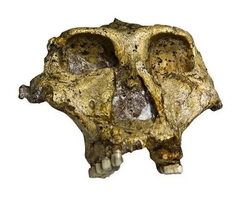
Malapa Cave, located within South Africa's Cradle of Humankind region, is one of the most important paleoanthropological discoveries of the twenty-first century. The site became internationally famous after the discovery of remarkably preserved remains of Australopithecus sediba, a hominin species that lived approximately 1.98 million years ago.

The fossils from Malapa are especially significant because they preserve unusually complete parts of the skeleton. Rather than providing researchers with only isolated teeth or fragments of skull, the Malapa discoveries include substantial portions of the skeleton. This allows scientists to investigate anatomy, locomotion, diet, growth, and evolutionary relationships in unusual detail. The Smithsonian's Human Origins Program dates Australopithecus sediba to approximately 1.977–1.98 million years ago.

Malapa therefore provides something much more valuable than another fossil specimen. It offers a detailed snapshot of a hominin living during a crucial period when several different human relatives occupied Africa.

The Discovery of Malapa

The Malapa fossils were discovered in 2008 during excavations associated with the Cradle of Humankind World Heritage landscape.

One of the most important specimens was a juvenile skeleton designated MH1.

Another major specimen, MH2, represented an adult individual.

The exceptional preservation of these individuals immediately attracted international attention.

The fossils included portions of the skull, teeth, spine, pelvis, hands, arms, legs, and feet.

This level of anatomical representation allowed researchers to reconstruct aspects of the body that are normally impossible to understand from fragmentary fossil material.

Australopithecus sediba

The species name Australopithecus sediba combines the genus Australopithecus with the Sesotho word "sediba," meaning "fountain" or "wellspring."

The name reflected the hope that the fossils would provide new information about human evolutionary origins.

The species displayed a remarkable combination of anatomical characteristics.

Some features resembled earlier australopithecines.

Others appeared more similar to members of the genus Homo.

The mosaic nature of its anatomy became central to the scientific debate surrounding Malapa.

A Mosaic Anatomy

MH1's skeleton demonstrates why human evolution cannot be represented as a simple ladder.

The skull retained several australopithecine characteristics.

The teeth also showed a combination of traits.

The pelvis, however, contained features that researchers considered more derived.

The hand anatomy suggested sophisticated grasping abilities.

The lower limbs indicated a form of bipedal locomotion.

This combination is important because evolution does not necessarily change every part of an organism simultaneously.

Different anatomical systems can evolve at different speeds.

Walking and Locomotion

One of the major questions surrounding Australopithecus sediba concerns how it moved.

The species was clearly adapted to some form of habitual bipedalism.

However, its anatomy does not simply reproduce the modern human pattern.

The pelvis and lower limbs suggest an unusual form of walking.

The foot and ankle anatomy also provides evidence for a locomotor system that combined older and more derived characteristics.

This makes Malapa particularly valuable for studying the evolution of upright walking.

The Hands

The hands of A. sediba are especially interesting.

The fossils suggest a combination of strong grasping capabilities and anatomical features that could have supported precision manipulation.

This raises questions about the relationship between locomotion, climbing, and tool-related behaviors.

However, the presence of an anatomically capable hand does not automatically prove that A. sediba made stone tools.

Stone artifacts and biological fossils must be associated carefully before a behavioral connection can be established.

The Brain

The skull of MH1 also provides information about brain evolution.

Although the brain was relatively small compared with that of later Homo, aspects of its shape have been investigated through endocranial reconstruction.

Researchers have debated whether the cerebral organization of A. sediba provides clues about the evolutionary changes that eventually produced the much larger brains of later humans.

The broader lesson is that brain evolution was gradual and complex.

Diet and Teeth

Dental anatomy provides evidence about diet.

The teeth of A. sediba contain features that distinguish the species from both earlier australopithecines and later hominins.

Researchers have also used microscopic wear and chemical analysis to investigate the foods consumed by the Malapa individuals.

The goal is not merely to identify individual foods but to understand the ecological strategy of the species.

The Malapa Environment

The cave did not exist in isolation.

The surrounding landscape contained woodland, grassland, water sources, and diverse animal life.

Understanding the environment is essential because human evolution is fundamentally connected to ecological change.

Hominins did not evolve in laboratories.

They responded to changing food resources, predators, climate, vegetation, and terrain.

Did Malapa Produce Tools?

The chronological position of Malapa is especially interesting because it overlaps with major changes in hominin technology.

Stone tools are known from Africa by at least several million years ago, although the exact identities of their makers remain uncertain in many cases. The Smithsonian notes that the earliest known stone tools currently extend to approximately 3.3 million years ago, demonstrating that stone technology considerably predates A. sediba.

However, this does not establish that A. sediba made those tools.

The association must remain cautious.

Evolutionary Significance

One of the most important debates concerns where Australopithecus sediba fits within the human family tree.

Some anatomical characteristics appear sufficiently unusual that the species may represent a side branch of hominin evolution.

Other characteristics have been interpreted as potentially relevant to the emergence of Homo.

The fossils therefore do not provide a simple answer to the question of ancestry.

Instead, they demonstrate the diversity of hominins living around two million years ago.

Conclusion

Malapa Cave has transformed the study of human evolution by providing exceptionally complete remains of Australopithecus sediba.

The fossils show that human evolution was not a straightforward march from ape-like ancestors toward modern humans. Different anatomical systems changed at different rates, producing organisms with combinations of primitive and derived characteristics.

Malapa's greatest contribution may therefore be conceptual as much as anatomical: it demonstrates the complexity of evolutionary experimentation within the human lineage.

Sterkfontein Caves: Cradle of Humankind Fossils

September 27, 2026

Introduction

The Sterkfontein Caves are among the most famous paleoanthropological sites in the world. Located near Johannesburg within South Africa's Cradle of Humankind World Heritage property, the caves have produced an extraordinary collection of hominin fossils spanning millions of years.

The importance of Sterkfontein is not based on one fossil.

It comes from the accumulation of evidence across generations of excavation.

Australopithecus fossils, animal remains, geological deposits, and archaeological materials together create a record of human evolutionary history extending deep into the Pliocene and Pleistocene.

UNESCO identifies the Sterkfontein, Swartkrans, Kromdraai, and associated sites as an exceptionally important concentration of evidence concerning early human evolution.

The Cradle of Humankind

The term "Cradle of Humankind" refers to a broad fossil-rich landscape rather than a single cave.

The region contains numerous cave systems formed in dolomitic limestone.

Water gradually dissolved underground cavities.

Sediments, animal remains, and other materials subsequently accumulated within these caves.

Some of those deposits eventually preserved hominin fossils.

The result is an extraordinary natural archive.

Early Discoveries

Sterkfontein became famous in the twentieth century through discoveries of early hominin fossils.

Among the most important was the adult female-like Australopithecus specimen known as "Mrs. Ples," although the sex and exact identification of the specimen have been subjects of scientific discussion.

The discovery demonstrated that australopithecines were not merely hypothetical creatures.

They were represented by substantial fossil populations.

Little Foot

Perhaps the most spectacular discovery associated with Sterkfontein is "Little Foot."

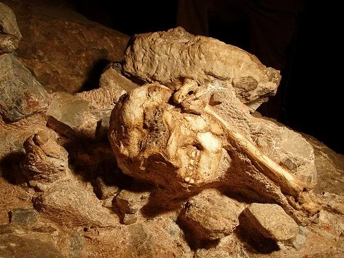
Little Foot is an exceptionally complete Australopithecus skeleton recovered from deep cave deposits.

Its preservation allows researchers to examine the relationship between the skeleton's anatomy and locomotion.

The discovery is important because complete skeletons are exceptionally rare in the fossil record.

Dating the Cave

Dating Sterkfontein is scientifically complicated.

Cave deposits can accumulate in multiple phases.

Different sediments may have entered the cave at different times.

Some fossil-bearing layers have also been affected by geological processes.

Researchers therefore use multiple dating techniques and geological interpretations.

This is why dates associated with Sterkfontein have sometimes changed as methods improved.

Human Evolution

The fossils from Sterkfontein demonstrate that southern Africa was inhabited by multiple hominin populations.

These populations did not necessarily represent a single evolutionary line.

Some may have been ancestors of later groups.

Others may have represented branches that eventually disappeared.

The cave therefore documents diversity rather than a simple chain of descent.

Anatomy

Australopithecine anatomy combines characteristics associated with both ape-like ancestors and later humans.

The pelvis and lower limbs show adaptations for upright walking.

The upper limbs retain characteristics associated with climbing.

The skull and teeth reveal dietary and evolutionary information.

This combination illustrates the mosaic nature of hominin evolution.

The Environment

The landscape surrounding Sterkfontein changed repeatedly over geological time.

Climate shifts altered vegetation.

Grasslands expanded and contracted.

Woodlands changed.

Water availability varied.

Animal communities changed alongside these environmental transformations.

Hominins were therefore living within dynamic ecosystems.

Taphonomy

One of the major challenges at cave sites is determining how fossils entered the caves.

Were animals deliberately carried inside?

Did predators drag carcasses into cavities?

Did individuals fall into shafts?

Were remains transported by water?

These questions belong to the field of taphonomy.

Understanding fossil accumulation is essential because the presence of a fossil in a cave does not automatically mean the animal lived there.

Stone Tools

Some archaeological evidence occurs within the broader Cradle of Humankind landscape.

Stone tools help demonstrate technological development among early hominins.

However, associating a particular tool industry with a particular fossil species is difficult unless both occur in secure archaeological context.

This is one of the central methodological challenges of paleoanthropology.

Why Sterkfontein Matters

UNESCO describes the fossil sites of the region as preserving an exceptionally long record of hominin evolution and notes that the Sterkfontein landscape has played a major role in establishing Africa's importance to human evolutionary research.

The site's importance therefore extends beyond individual discoveries.

Sterkfontein transformed scientific understanding of the antiquity and diversity of human ancestors.

Preservation

Cave environments are fragile.

Excavations can disturb sediments.

Tourism can affect microclimates.

Water movement can damage deposits.

Fossils and archaeological materials must therefore be carefully documented.

Preservation is especially important because excavation is irreversible.

Once a sediment layer is removed, it cannot be replaced in its original archaeological condition.

Conclusion

Sterkfontein Caves represent one of humanity's most important fossil archives.

Its importance lies not simply in the famous specimens found there but in the enormous chronological and biological diversity preserved across the cave system.

The fossils demonstrate that human evolution occurred through a complex branching history involving numerous species and populations.

For that reason, Sterkfontein remains central to understanding humanity's deep African past.

Makapansgat: South Africa's 3M-Year-Old Tools

September 27, 2026

Introduction

Makapansgat, located in South Africa's Limpopo Province, is one of the most important archaeological and paleoanthropological landscapes associated with early hominin evolution.

The site belongs to the broader Makapan Valley, which contains caves and deposits preserving evidence of hominins, animals, environmental change, and early technological behavior.

UNESCO identifies Makapan Valley as part of the Fossil Hominid Sites of South Africa and notes archaeological and evolutionary evidence extending to approximately 3.3 million years ago.

The title "3M-Year-Old Tools" requires an important qualification, however. Very early stone artifacts around three million years old are now known from Africa, but identifying the exact toolmaker is difficult, and the evidence traditionally associated with Makapansgat includes objects whose intentional manufacture and interpretation have been debated.

Makapan Valley

The Makapan Valley contains multiple cave sites.

These sites formed through geological processes involving limestone and groundwater.

Over long periods, caves accumulated sediments, animal remains, and other materials.

The result is a complex stratigraphic record.

Early Hominins

Makapansgat has produced fossil evidence of early australopithecines.

These fossils are important because they demonstrate that hominins were living in southern Africa millions of years ago.

The region therefore contributes to a broader understanding of the geographic distribution of early hominins.

The Famous Pebble

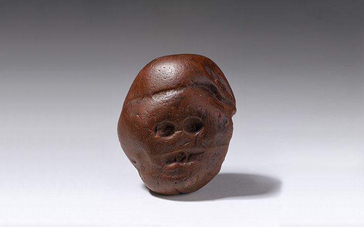
Makapansgat is particularly famous for a reddish-brown stone sometimes called the "Makapansgat pebble."

The object has naturally occurring patterns that some researchers argued resemble a face or animal-like form.

This led to speculation that an australopithecin may have selected it because of its visual resemblance.

Such interpretations are fascinating but controversial.

Natural Object or Artifact?

Archaeologists distinguish between naturally modified objects and intentionally manufactured artifacts.

A stone can look meaningful to a modern observer without having been intentionally selected by a prehistoric person.

To demonstrate deliberate selection, researchers ideally need evidence of:

  • unusual location;

  • repeated selection;

  • modification;

  • transport;

  • associated artifacts;

  • use-wear;

  • archaeological context.

The Makapansgat pebble does not provide an unambiguous demonstration of symbolic thought.

The Problem of Pareidolia

Humans naturally recognize familiar forms in random patterns.

We see faces in clouds, rocks, shadows, and stains.

This phenomenon is called pareidolia.

Because prehistoric objects are interpreted through modern perception, archaeologists must be particularly cautious when claiming that a naturally shaped object had symbolic significance.

Stone Technology in Deep Time

The broader question of early stone technology is nevertheless extremely important.

The archaeological record now demonstrates that stone toolmaking is older than many twentieth-century scholars once believed.

The Smithsonian notes that the earliest known stone tools currently extend to approximately 3.3 million years ago.

This means technological behavior appeared much earlier than the genus Homo.

Who Made the Earliest Tools?

This remains one of the major questions.

Multiple hominin species lived in Africa during the period when early stone tools appeared.

The discovery of approximately three-million-year-old tools in Kenya, for example, has reinforced the possibility that hominins other than early Homo may have been capable of toolmaking. The Smithsonian notes that determining which hominin species made early tools is difficult because several hominins could occupy the same landscape.

The same caution applies when interpreting southern African evidence.

Makapansgat and Behavior

Makapansgat is valuable because it provides an opportunity to study early hominin behavior at a time when anatomical evolution and technological evolution were both changing.

The site helps researchers ask broader questions:

How early did hominins manipulate objects?

When did stone technology become systematic?

When did selection of unusual objects become meaningful?

When did symbolic behavior emerge?

These questions cannot always be answered by one artifact.

Cave Stratigraphy

Makapansgat's importance also lies in its geological record.

Different layers preserve different periods.

Researchers can examine sediment composition, animal fossils, environmental indicators, and hominin remains together.

This creates a chronological framework for interpreting behavior.

Climate and Environment

Three million years ago, southern Africa was not identical to the modern landscape.

Vegetation patterns shifted over time.

Large mammals inhabited different ecological zones.

Climate fluctuations influenced resource availability.

Hominins adapted to these changing environments.

Archaeological Method

The history of Makapansgat illustrates why archaeology requires careful distinction between observation and interpretation.

An object can be described objectively.

Its possible purpose is an interpretation.

Its symbolic meaning is an even more difficult interpretation.

Good archaeological scholarship keeps these levels separate.

Conclusion

Makapansgat is an important window into the deep history of southern African hominins.

The site is associated with some of the earliest evidence relevant to questions of object selection and technological behavior, but claims about three-million-year-old tools or symbolic artifacts must be treated carefully.

Its real importance lies in the broader record: Makapan Valley preserves evidence of hominin evolution extending millions of years and contributes to the increasingly complex picture of how early humans and their relatives interacted with their environments.

Border Cave: South Africa's 200,000-Year Sequence

September 27, 2026

Introduction

Border Cave, located near the border between South Africa and Eswatini, is one of the most important archaeological sites for understanding human behavioral evolution in southern Africa.

The cave preserves an unusually long sequence of occupation.

Its archaeological deposits include stone tools, animal remains, plant materials, hearths, ornaments, human remains, and other evidence of repeated human activity.

The site is particularly valuable because it demonstrates that sophisticated human behavior developed through a long process rather than appearing suddenly during one brief "revolution."

Location and Environment

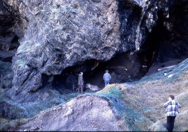
Border Cave lies within a mountainous landscape close to the Lebombo Mountains.

Its position gave prehistoric communities access to a diverse range of ecological resources.

The surrounding region included grasslands, woodland, rocky environments, and water sources.

This ecological diversity contributed to the site's long-term attractiveness.

Deep Occupation

The archaeological sequence at Border Cave extends deep into the Middle Stone Age and later periods.

Researchers have recovered evidence spanning well over 100,000 years.

The title's "200,000-year sequence" is therefore best understood as referring to the site's exceptionally long archaeological record rather than a single continuous occupation without interruptions.

Human groups came and went.

Different technologies appeared.

Environmental conditions changed.

Human Remains

Border Cave has produced several human remains.

These are important because skeletal evidence can be compared with archaeological material found in the same broader sequence.

The association between human biology and cultural behavior is central to understanding evolution.

Stone Tools

Stone artifacts at Border Cave document technological change.

Early Middle Stone Age technologies differ from later industries.

Changes in tool production reveal shifts in raw-material selection, reduction strategies, and tool design.

Technology can therefore act as a chronological marker.

Fire

Hearths are among the most important archaeological features.

Controlled fire provided heat, light, protection, and cooking.

Fire also changed the nutritional value of foods and allowed people to occupy colder environments.

Repeated hearths demonstrate that caves were used as organized living spaces.

Food

Animal remains provide evidence of hunting and consumption.

Plant remains can sometimes survive through microscopic or chemical traces.

Together, these materials allow researchers to reconstruct subsistence strategies.

The people who used Border Cave were not dependent on one resource.

They exploited diverse foods.

Symbolic Objects

One of the most important aspects of Border Cave is its evidence for symbolic behavior.

Objects such as ornaments can indicate social communication.

However, symbolism should not be reduced to a simple definition such as "art."

Symbolic behavior can include identity, social affiliation, personal decoration, ritual activity, information exchange, and cultural traditions.

Organic Technology

Organic materials are often missing from archaeological sites because wood, fibers, and skin decay.

Border Cave's preservation conditions have occasionally allowed unusually informative organic remains to survive.

These materials can provide evidence of technologies that stone artifacts alone cannot reveal.

Changing Technology

Over tens of thousands of years, people changed how they made tools.

This included alterations in stone selection, flaking techniques, tool forms, and composite technologies.

Composite tools are particularly important because they combine multiple materials.

A stone point may have been attached to wood.

Adhesives may have been used.

Binding materials may have held components together.

Such technologies require planning.

Human Evolution

Border Cave contributes to the debate about the emergence of modern human behavior.

Rather than assuming that "modern behavior" appeared suddenly, researchers can observe a long sequence of experimentation.

People increasingly manipulated diverse materials.

They created personal ornaments.

They used fire systematically.

They developed specialized tools.

These behaviors reveal growing technological flexibility.

Climate Change

The site's long sequence also records environmental fluctuations.

Southern Africa experienced repeated climatic changes during the Pleistocene.

Periods of colder or drier conditions altered vegetation and animal populations.

Human communities adapted to these changes.

This makes Border Cave important not only for archaeology but also for paleoenvironmental reconstruction.

Conclusion

Border Cave is valuable because it preserves a long record of human adaptation.

Its archaeology shows that technology, subsistence, fire use, and symbolic behavior developed through extended periods of experimentation.

Rather than revealing one dramatic moment when humans suddenly became "modern," Border Cave documents a long and complicated process of biological and cultural change.

Klasies River Caves: South Africa's Modern Human Origin

September 27, 2026

Introduction

The Klasies River caves on South Africa's southern coast are among the most important sites for understanding the emergence and early history of Homo sapiens.

The caves contain Middle Stone Age archaeological deposits, human remains, animal bones, shellfish, hearths, and stone tools.

Their importance is especially strong because the archaeological sequence demonstrates repeated occupation by populations of anatomically modern humans and provides evidence for sophisticated coastal adaptation.

However, the title "Modern Human Origin" should not be interpreted as meaning that modern humans originated exclusively at Klasies River.

Human evolution was an African process involving populations across the continent.

Klasies River represents one important region within that larger story.

The Southern Cape

Klasies River lies along South Africa's southern coast.

The region provides access to marine resources, terrestrial animals, plants, and freshwater.

This ecological diversity made the coastline an attractive environment for prehistoric hunter-gatherers.

Human Remains

Klasies River has produced human remains associated with Middle Stone Age deposits.

These remains have been important in discussions about the emergence of anatomically modern humans.

Research has emphasized that some Klasies River specimens display a mixture of anatomical characteristics rather than fitting perfectly into simplistic categories.

One scholarly review notes that Klasies River remains dating to roughly 130,000 years ago display a mosaic of archaic and modern anatomical traits.

The Meaning of "Modern"

"Modern human" can mean different things.

Biologically, it may refer to anatomical characteristics associated with Homo sapiens.

Behaviorally, researchers may discuss traits such as symbolism, long-distance exchange, complex tools, and social organization.

These categories do not necessarily appear at the same time.

A population can be anatomically modern while still displaying cultural behaviors that differ from those of later societies.

Coastal Resources

Klasies River provides important evidence for the use of marine resources.

Shellfish were collected along the coast.

Marine foods expanded the available nutritional resource base.

Coastal environments could therefore provide reliable resources during periods when terrestrial foods became less predictable.

Shell Middens

Accumulations of shellfish remains form archaeological deposits known as shell middens.

These are not simply garbage heaps.

They preserve evidence about diet, seasonality, coastal ecology, and human behavior.

Species composition can reveal what people collected.

Shell size can sometimes provide information about environmental conditions.

Burning patterns can indicate cooking.

Hearths

Fireplaces occur throughout the archaeological sequence.

Hearths reveal repeated occupation.

Burned bones demonstrate cooking or other activities.

Charcoal can provide evidence for fuel selection and vegetation.

Fire also structured social activity.

People gathered around it for cooking, warmth, tool production, and social interaction.

Stone Tools

The Middle Stone Age tools at Klasies River demonstrate sophisticated stone-working strategies.

People selected appropriate raw materials.

They shaped cores.

They produced flakes and points.

They maintained tool edges.

Technological traditions changed through time.

Hunting

Animal remains reveal terrestrial hunting and scavenging.

Butchery marks can provide evidence of carcass processing.

Cut marks indicate contact with stone tools.

Burned bones may indicate cooking.

Together, these traces allow researchers to reconstruct subsistence.

Climate and Coastal Adaptation

The southern Cape experienced major climatic fluctuations during the Pleistocene.

Sea levels changed.

The coastline moved.

Vegetation shifted.

Yet humans repeatedly returned to the region.

This suggests considerable ecological flexibility.

Human Origins

The broader question of modern human origins cannot be reduced to one cave.

Africa contained multiple populations of Homo sapiens and closely related populations.

Gene flow and population movement likely occurred across large geographic areas.

Southern Africa was therefore one important part of a continental evolutionary landscape.

Cultural Significance

Klasies River is also significant because it helps demonstrate that sophisticated behavior was present among Middle Stone Age populations.

People organized their diets.

Used fire.

Made complex tools.

Exploited marine resources.

Maintained repeated occupation of coastal landscapes.

These behaviors demonstrate planning and ecological knowledge.

Conclusion

Klasies River Caves are among the most important sites for understanding early Homo sapiens in Africa.

They provide evidence of anatomically modern humans, complex Middle Stone Age technology, marine resource exploitation, fire use, hunting, and repeated occupation.

Rather than representing a single "birthplace" of modern humanity, Klasies River should be understood as one of several crucial African archives documenting the emergence and development of our species.

Blombos Cave: South Africa's 75,000-Year Ochre Art

September 27, 2026

Introduction

Blombos Cave, located along the southern Cape coast of South Africa, is one of the world's most important archaeological sites for studying the development of symbolic behavior.

The cave is particularly famous for engraved ochre pieces, beads, bone tools, and other Middle Stone Age artifacts.

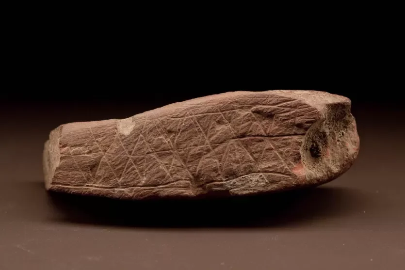
Among the most celebrated discoveries are ochre plaques bearing geometric engravings dating to approximately 75,000 years ago.

The Smithsonian Human Origins Program dates a famous engraved Blombos ochre plaque to approximately 77,000–75,000 years ago and notes that its organized markings may have represented information rather than simple decoration.

What Is Ochre?

Ochre is a naturally occurring earth pigment containing iron minerals.

It can produce red, yellow, brown, and orange colors.

Prehistoric people used ochre for numerous purposes.

It could be applied to skin.

It could be used to color objects.

It could be incorporated into adhesives.

It may have been used in symbolic practices.

Therefore, the discovery of ochre alone does not necessarily prove artistic behavior.

The Engraved Plaques

The Blombos engravings are more significant because the marks are deliberate and organized.

Some consist of intersecting lines forming geometric patterns.

The repetition suggests that the markings were intentionally produced.

Researchers have debated what they meant.

They could have been decorative.

They could have communicated identity.

They could have represented information.

They might have served social or ritual functions.

No single interpretation is universally accepted.

Symbolic Behavior

Symbolic behavior involves using an object, mark, sound, or action to represent something beyond its immediate physical function.

This is difficult to identify archaeologically.

A geometric mark does not automatically reveal its meaning.

However, repeated standardized designs suggest that cultural conventions may have existed.

That possibility makes Blombos extraordinarily important.

Beads

Blombos has also produced shell beads.

Personal ornaments are particularly significant because they may communicate social identity.

People can use beads to indicate membership in a group, age category, social status, or personal identity.

The archaeological evidence cannot always identify the exact meaning.

But the existence of repeated ornament traditions demonstrates that objects could have social significance.

Bone Tools

Bone tools from Blombos provide additional evidence of technological sophistication.

Bone is more difficult to preserve than stone.

Its survival at the site provides a rare opportunity to study organic technology.

Bone points and other implements reveal that Middle Stone Age people worked multiple materials.

The Coastal Environment

Blombos is located near a productive marine environment.

Shellfish, fish, and terrestrial resources could all be exploited.

The cave's inhabitants were therefore operating within a diverse ecological system.

Technological Planning

Some Blombos artifacts reveal multiple stages of production.

Raw materials had to be collected.

Stone had to be selected.

Ochre had to be processed.

Tools had to be manufactured.

Adhesive technologies may have required mixing different substances.

These processes imply planning beyond immediate survival.

Dating

The age of Blombos artifacts is important because it places symbolic behavior deep in the Middle Stone Age.

The famous engraved ochre pieces are roughly 75,000 years old.

This means deliberate marking and ornamentation were present long before the emergence of many later archaeological traditions.

Was Blombos the Beginning of Art?

It would be misleading to describe Blombos as the place where art "began."

Older evidence for pigment use and possible symbolic behavior exists elsewhere in Africa.

Blombos instead provides unusually clear evidence for intentional marking.

It is therefore one important chapter in a much longer history of symbolic behavior.

Archaeological Context

Context is critical.

The engravings were found within controlled archaeological deposits.

Researchers can examine their association with tools, shells, animal remains, hearths, and other materials.

This allows the artifacts to be interpreted as part of a living community rather than isolated curiosities.

Conclusion

Blombos Cave provides some of the strongest evidence for symbolic material culture in the Middle Stone Age.

Its engraved ochre pieces, beads, bone tools, and other artifacts demonstrate that humans living around 75,000 years ago manipulated objects in increasingly complex ways.

The cave does not reveal the exact meaning of every mark.

But it demonstrates something profound: long before written language, people were creating material signs that may have carried information, identity, or cultural meaning.

Sibudu Cave: South Africa's 77,000-Year Bedding

September 27, 2026

Introduction

Sibudu Cave, located in KwaZulu-Natal, is one of the most important Middle Stone Age archaeological sites in southern Africa.

The cave is famous for evidence of plant bedding, fire management, adhesives, bone tools, personal ornaments, and advanced stone technologies.

The site is particularly important because organic remains provide a rare glimpse into daily life.

Stone tools are abundant at archaeological sites, but the softer materials humans used—grass, leaves, wood, fibers, and bedding—usually disappear.

Sibudu preserves some of these materials.

The Cave Environment

Sibudu occupies a rock shelter overlooking a river valley.

Its elevated position provided protection while maintaining access to water and surrounding resources.

The surrounding vegetation supported a diverse ecological system.

This made the location suitable for repeated occupation.

Ancient Bedding

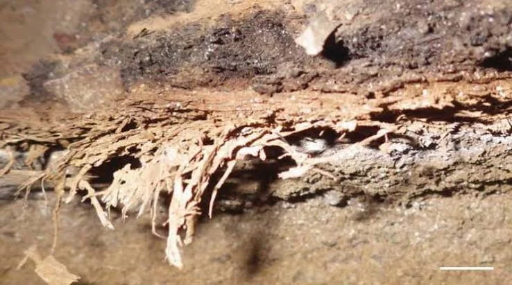
One of Sibudu's most famous discoveries involves layers of plant material interpreted as bedding.

People appear to have intentionally collected grasses and leaves and placed them inside the shelter.

The material was repeatedly replaced and reorganized.

This suggests deliberate management of living space.

Why Bedding Matters

Bedding may appear mundane.

Yet it tells us a great deal about human behavior.

Creating bedding requires:

  1. collecting plant materials;

  2. transporting them;

  3. arranging them;

  4. maintaining the sleeping area;

  5. replacing old material.

This implies repeated organization of domestic space.

Fire

Fire was also central to life at Sibudu.

Hearths and burned plant remains demonstrate controlled fire use.

Fire could provide:

  • warmth;

  • light;

  • cooking;

  • protection;

  • insect control;

  • material processing.

Its presence alongside bedding suggests that the cave functioned as a residential environment rather than merely a temporary hunting location.

Insect Repellent

Some researchers have proposed that particular aromatic plants in bedding may have helped repel insects.

The possibility is significant because it suggests environmental knowledge.

People were not simply collecting plants for food.

They were selecting species for practical properties.

Stone Technology

Sibudu preserves sophisticated Middle Stone Age lithic technologies.

Different tool forms appear in different layers.

The site has contributed significantly to understanding technological innovation before the emergence of Later Stone Age industries.

Bone Tools

Bone tools are particularly important.

Stone is abundant in archaeological contexts, but bone tools demonstrate technological flexibility.

The manufacture of bone points requires knowledge of shaping, grinding, and modification.

Bow-and-Arrow Technology

Sibudu has also contributed to debates about early projectile technology.

Evidence from Middle Stone Age layers includes small stone segments and bone points that have been interpreted as consistent with bow-and-arrow technology.

A Cambridge review notes evidence from Sibudu for bone-point and segment technologies around 72,000–77,000 years ago, with later evidence associated with a Howiesons Poort layer around 61,700 years ago.

This is significant because it pushes complex projectile technology deep into the Middle Stone Age.

Adhesive Technology

Sibudu also preserves evidence relevant to compound adhesives.

An adhesive is especially important because it requires combining materials.

A person may need resin, ochre, plant gum, or another substance.

The mixture may require heating or controlled preparation.

This is technological chemistry in a prehistoric context.

Personal Ornaments

Ornaments provide another dimension.

Beads and decorative objects can communicate identity.

They may also have served as social markers.

Again, archaeology cannot always determine exact meanings.

But repeated ornament traditions demonstrate social communication.

The Household

Perhaps Sibudu's greatest contribution is that it reveals prehistoric life at a household scale.

People slept there.

They worked there.

They processed plants.

They made tools.

They controlled fires.

They prepared food.

They discarded waste.

The site therefore resembles an archaeological snapshot of domestic life.

Conclusion

Sibudu Cave demonstrates that Middle Stone Age humans possessed sophisticated knowledge of plants, fire, materials, and domestic organization.

The ancient bedding is particularly significant because it provides evidence for deliberate modification of living space.

Combined with bone tools, projectile technology, adhesives, ornaments, and fire use, the site shows that humans tens of thousands of years ago were already organizing their environments in complex ways.

Diepkloof Rock Shelter: South Africa's Ostrich Egg Containers

September 27, 2026

Introduction

Diepkloof Rock Shelter, located in South Africa's Western Cape, is one of the most important Middle Stone Age sites for understanding the development of symbolic communication and everyday technology.

The site is particularly famous for engraved ostrich eggshell fragments.

Researchers have recovered hundreds of engraved pieces, including approximately 408 documented fragments in one major study.

The title's reference to "containers" is especially important because ostrich eggshells were not merely decorative materials. Hollow eggs could be transformed into useful vessels capable of storing and transporting liquids.

Ostrich Eggs in the Middle Stone Age

Ostrich eggs are large and durable.

After the contents are removed, the shell can function as a container.

A hole can be made in the shell.

The opening can then be used to access the interior.

In some contexts, the shell could be sealed or modified.

This created a lightweight portable container.

Why Containers Matter

Portable containers are enormously useful to mobile hunter-gatherers.

Water can be collected.

Liquid foods can be transported.

Resources can be stored.

A container allows people to move beyond immediate water sources.

This changes the geography of mobility.

Engraved Shell

Diepkloof's engraved ostrich eggshell is important because many fragments contain repeated geometric designs.

The marks are not random scratches.

They display organized patterns.

The patterns changed through time.

This suggests cultural traditions.

Symbolic Communication

Researchers have interpreted the repeated geometric motifs as possible evidence of symbolic communication.

However, the exact meaning remains unknown.

The markings may have communicated group identity.

They may have helped distinguish one container from another.

They may have carried social information.

Or they may have had several functions simultaneously.

Function and Symbolism

A major archaeological insight from Diepkloof is that functional and symbolic behavior do not have to be separate.

An object can be useful and meaningful.

A decorated container can still be a container.

The markings may have enhanced social information while the vessel remained a practical technological tool.

Chronology

The engraved eggshell tradition is associated particularly with Howiesons Poort deposits dating to approximately 60,000 years ago.

This places the behavior deep within the Middle Stone Age.

Technological Skill

Manufacturing ostrich eggshell containers required considerable skill.

The shell had to be opened without destroying it.

Edges needed to be managed.

Fragments could be modified.

A completed vessel needed to survive repeated handling.

This indicates knowledge of material properties.

Mobility

The existence of portable containers suggests adaptation to environments in which water and resources were unevenly distributed.

Hunter-gatherers often moved between locations.

Carrying water increased their flexibility.

Technology therefore affected settlement and movement.

Archaeological Preservation

Ostrich eggshell is unusually durable.

It survives better than many organic materials.

This makes it particularly valuable archaeologically.

At Diepkloof, the shell fragments preserve evidence that would otherwise be lost.

Social Identity

Repeated decorative patterns may have functioned as social identifiers.

If different groups used different designs, markings could communicate affiliation.

This interpretation remains hypothetical.

Archaeologists therefore study patterns statistically and compare them across time and space.

Conclusion

Diepkloof Rock Shelter demonstrates that Middle Stone Age technology was both practical and socially meaningful.

Ostrich eggshell provided lightweight containers, while engraved designs may have communicated information about identity or social relationships.

The hundreds of engraved fragments reveal a population capable of standardizing designs and maintaining cultural traditions over time.

Pinnacle Point: South Africa's 164,000-Year Heat Treatment

September 27, 2026

Introduction

Pinnacle Point, located along South Africa's southern coast, is one of the world's most important archaeological landscapes for understanding early modern human behavior.

The site is particularly famous for evidence of coastal adaptation, pigment use, shellfish exploitation, and sophisticated stone-tool production.

One of its most important technological discoveries concerns the controlled heating of silcrete to improve its flaking properties approximately 164,000 years ago.

The Coastal Landscape

Pinnacle Point consists of a series of caves and shelters overlooking the Indian Ocean.

The location provided access to marine resources.

Shellfish were particularly important.

The coast also offered terrestrial plants and animals.

This combination created a highly productive environment.

Marine Resource Use

Marine resources are significant because they provide predictable food.

Tides repeatedly expose shellfish.

People can collect them without the complex hunting strategies required for large terrestrial animals.

Repeated shellfish consumption therefore demonstrates ecological knowledge.

Heat Treatment

One of Pinnacle Point's most important technological discoveries is evidence that people deliberately heated silcrete.

Silcrete is a hard stone material.

When heated under controlled conditions, its physical properties can change.

The stone can become easier to fracture.

This allows knappers to produce sharper and more predictable flakes.

Why This Is Technologically Important

Heat treatment is not simply "putting a rock in a fire."

Successful heat treatment requires:

  1. selecting appropriate raw material;

  2. understanding its properties;

  3. heating it to a suitable temperature;

  4. controlling the heating environment;

  5. allowing it to cool;

  6. recognizing the resulting change in knapping behavior.

This is a complex technological process.

Controlled Fire

The technology demonstrates that people understood relationships between fire and stone.

Fire was no longer simply a source of warmth or cooking.

It became part of a manufacturing process.

This represents an important expansion of technological knowledge.

The Date

Evidence from Pinnacle Point places this technology around 164,000 years ago.

That makes it substantially older than many traditional assumptions about advanced technological planning.

It demonstrates that Middle Stone Age humans possessed sophisticated knowledge of materials long before the appearance of many later archaeological industries.

Pigments

Pinnacle Point has also produced ochre.

Pigments may have been used for a range of practical and symbolic purposes.

The combination of pigment processing and heat-treated stone suggests a population capable of manipulating materials in sophisticated ways.

Climate Change

The site's coastal location is particularly important for understanding climate change.

During periods of glacial expansion, sea levels changed.

Coastlines moved.

Marine resources could therefore become more or less accessible.

The repeated use of Pinnacle Point demonstrates that humans adapted to changing coastal environments.

Population Survival

Some researchers have argued that southern African coastal resources may have provided relatively stable food supplies during harsh climatic periods.

This raises an important evolutionary possibility.

Coastal environments may have helped sustain human populations during periods when inland ecosystems became less productive.

Technology and Cognition

Heat treatment requires planning over time.

The decision to prepare stone before tool production indicates anticipation.

The person preparing the stone may not immediately benefit from the activity.

This is evidence for delayed-return technological behavior.

Broader Importance

Pinnacle Point helps challenge the idea that complex technology appeared suddenly in Europe or near the end of the Pleistocene.

Instead, sophisticated material knowledge was already present in Africa.

Conclusion

Pinnacle Point is important because it connects environmental adaptation, coastal subsistence, fire technology, and stone-tool innovation.

The controlled heating of silcrete around 164,000 years ago demonstrates that Middle Stone Age humans understood how fire could alter the physical properties of stone.

This was not simply survival through instinct.

It was technological experimentation based on accumulated knowledge.

Howiesons Poort: South Africa's Middle Stone Age Points

September 27, 2026

Introduction

The Howiesons Poort is one of the best-known archaeological techno-complexes of the African Middle Stone Age.

Rather than being a single archaeological site, it refers to a technological tradition identified at multiple sites in southern Africa.

It is characterized by distinctive stone-tool technologies, including backed artifacts and carefully produced points or segments.

The Howiesons Poort is particularly important because it demonstrates technological innovation, standardization, and adaptation among Middle Stone Age populations.

What Is a Techno-Complex?

Archaeologists use the term "techno-complex" to describe a recurring technological pattern found across multiple sites.

It does not necessarily represent one ethnic group.

Nor does it necessarily describe one political or cultural population.

Different communities may independently share technological traditions.

The Howiesons Poort Period

The Howiesons Poort occurred during the Middle Stone Age.

Its chronology varies by site, but it broadly belongs to a period tens of thousands of years ago.

The technology represents a distinct phase within the broader southern African archaeological sequence.

Stone Points

Points are among the most important forms.

Sharp pointed artifacts could be used in hunting weapons.

They may have been hafted onto shafts.

This would produce composite projectile systems.

Backed Tools

Backed artifacts were made by deliberately modifying one edge.

This could produce a sharp working edge while creating a blunt side suitable for handling or hafting.

Such tools demonstrate deliberate standardization.

Composite Technology

Composite tools are particularly significant.

A stone artifact can be combined with wood, resin, sinew, bone, or other materials.

Much of the resulting technology disappears archaeologically because organic components decay.

The surviving stone point may therefore represent only one part of a much larger tool.

Hunting

Projectile technology could dramatically increase hunting efficiency.

A projectile allows the hunter to attack animals from a distance.

This reduces direct physical danger.

However, identifying the exact use of every point remains difficult.

Some points may have been knives, cutting tools, or components of other equipment.

Hafting

Hafting involves attaching a stone or bone component to a handle or shaft.

It requires adhesive technology and binding.

This is technologically complex because different materials expand and contract differently.

The adhesive must remain strong.

The attachment must withstand repeated impact.

Innovation

The Howiesons Poort demonstrates that Middle Stone Age populations repeatedly experimented with technology.

Innovation was not a one-time event.

Technological systems changed, disappeared, and reappeared.

Social Transmission

Standardized technologies suggest that knowledge was transmitted between people.

A particular tool design can persist across generations only if individuals learn it from others.

This provides evidence for social learning.

Regional Variation

Howiesons Poort artifacts are not identical everywhere.

Different sites contain different proportions of tool types.

Raw-material availability also influenced technology.

This demonstrates that technological traditions were flexible rather than mechanically standardized.

Behavioral Significance

The Howiesons Poort has often been discussed in debates about modern human behavior.

The complexity of its tools demonstrates planning.

Its standardized designs demonstrate learned traditions.

Its composite technologies demonstrate multi-stage production.

Together, these features provide evidence for sophisticated cognition.

Conclusion

The Howiesons Poort represents a major technological phase in southern Africa's Middle Stone Age.

Its points, backed tools, and composite technologies reveal populations capable of planning, standardization, and complex social learning.

Rather than appearing suddenly with the rise of later cultures, sophisticated technology was already emerging and changing within Africa's Middle Stone Age societies.

Kathu Pan: South Africa's 500,000-Year Spears

September 27, 2026

Introduction

Kathu Pan, located in South Africa's Northern Cape, is one of the most important archaeological sites for understanding early hunting technology.

The site has produced evidence of stone points dating to roughly half a million years ago that have been interpreted as possible components of hafted spears.

The significance of Kathu Pan lies in the possibility that humans were producing complex hunting weapons far earlier than once assumed.

The Kathu Pan Landscape

Kathu Pan is part of a landscape containing archaeological deposits associated with ancient water and wetland environments.

These environments attracted animals.

Where animals gathered, human hunters also had opportunities.

The site therefore provides evidence for the interaction between water, animals, and human settlement.

Stone Points

Archaeologists recovered large numbers of stone points.

Their shapes suggest intentional production for particular functions.

The points were carefully flaked.

Some show characteristics consistent with use as weapon tips.

Spears

A stone point by itself does not automatically prove a spear.

A spear is a composite object.

It may consist of:

  • wooden shaft;

  • stone point;

  • adhesive;

  • binding material.

Most of these components decay.

Archaeologists therefore rely on indirect evidence such as point morphology, impact damage, residue, experimental comparisons, and spatial context.

The Age of the Evidence

Kathu Pan is important because the relevant archaeological material dates to approximately 500,000 years ago.

This pushes complex projectile technology deep into the Middle Pleistocene.

The evidence therefore predates the widespread appearance of many later projectile traditions.

Hunting Technology

A hafted spear dramatically changes hunting possibilities.

Instead of approaching an animal with a simple wooden club, a hunter can use a pointed weapon capable of penetrating tissue.

A spear can be thrust at close range or potentially thrown, depending on its design.

Cooperative Hunting

Complex projectile weapons may also have implications for social organization.

Large-animal hunting often requires cooperation.

Hunters must coordinate movement.

They need knowledge of animal behavior.

They may have to anticipate escape routes.

Although direct evidence for specific hunting strategies is difficult to recover, weapon technology provides clues about these capabilities.

Fire and Hafting

Composite tools often require adhesives.

Adhesive production may involve heating plant resins or other substances.

If early populations were capable of producing effective adhesives, this would demonstrate chemical and technological knowledge.

Raw Materials

Toolmakers selected stone according to its properties.

A good spear point requires stone capable of producing strong sharp edges.

Raw-material procurement therefore reflects knowledge of geology.

Human Evolution

Who made the Kathu Pan points?

This is an important question.

The archaeological layers do not necessarily contain a fossil directly identifying the toolmakers.

Several Middle Pleistocene hominin populations occupied Africa.

Therefore, the safest interpretation is that the tools were made by hominins rather than assigning them automatically to one named species.

Broader Significance

Kathu Pan contributes to a broader pattern of evidence for early complex technology.

It complements discoveries from other African sites demonstrating that hominins were capable of planning multi-component tools long before the Late Pleistocene.

Conclusion

Kathu Pan is important because its approximately half-million-year-old stone points provide evidence relevant to the early history of hafted hunting weapons.

Whether every point functioned specifically as a spear tip cannot be demonstrated with certainty.

Nevertheless, the site strongly supports the conclusion that Middle Pleistocene hominins possessed sophisticated stone-working and hunting technologies.

Florisbad: South Africa's 259,000-Year-Old Skull

September 27, 2026

Introduction

Florisbad, located in South Africa's Free State Province, is famous for a remarkably important human fossil discovered in association with a Middle Pleistocene archaeological and environmental record.

The Florisbad skull is generally dated to roughly 259,000 years ago and has played a major role in discussions about the evolution of Homo sapiens.

Its significance comes from its unusual anatomy.

The specimen appears neither completely archaic nor identical to later anatomically modern humans.

Instead, it represents a population during a period of major evolutionary change.

The Florisbad Site

Florisbad is associated with an ancient spring and lake environment.

Water attracted animals and provided opportunities for human occupation.

Over time, sediments accumulated around the ancient wetland.

These sediments preserved animal remains and archaeological material.

The Skull

The human fossil was discovered in the twentieth century.

It consists primarily of a partial skull.

Its anatomy displays a mixture of characteristics.

Some features resemble earlier Middle Pleistocene humans.

Others are compatible with populations approaching anatomically modern Homo sapiens.

Evolutionary Mosaic

Florisbad is important precisely because it does not fit neatly into one category.

Evolution often produces transitional populations whose anatomy combines multiple characteristics.

This does not mean that Florisbad represents a single "missing link."

The concept of a missing link is misleading because human evolution involved branching populations rather than one straight chain.

Dating

The fossil is commonly associated with an age around 259,000 years.

This places it within the Middle Pleistocene, a period when African populations were undergoing major evolutionary changes.

The date is particularly important because it falls relatively close to the period when early forms of Homo sapiens appear in the African fossil record.

Archaeological Evidence

Florisbad also contains stone tools and animal remains.

These materials provide environmental context.

The human fossil is therefore not an isolated anatomical specimen.

It belongs to a broader archaeological landscape.

Climate

The ancient spring environment changed with climate.

Wet and dry periods altered the lake and surrounding vegetation.

Animals responded to these changes.

Humans exploited the landscape according to available resources.

Human Evolution in Africa

Florisbad supports the broader view that modern human evolution was geographically complex.

Populations in different regions may have exchanged genes.

Anatomical characteristics could spread gradually.

Different populations could maintain distinctive traits while contributing to later Homo sapiens populations.

Relationship to Modern Humans

Researchers have debated exactly how Florisbad relates to later Homo sapiens.

Some classifications have placed the specimen within or near the evolutionary history of early Homo sapiens.

Others emphasize its distinct morphology.

The uncertainty is scientifically valuable.

It demonstrates that the evolutionary history of our species remains an active field of research.

Archaeological Context

The association between fossil, stone tools, fauna, and ancient environmental deposits allows researchers to study both biology and behavior.

The site demonstrates that human evolution cannot be separated from environmental history.

Conclusion

Florisbad provides one of the most important human fossils from Middle Pleistocene Africa.

Its approximately 259,000-year-old skull preserves a mosaic of anatomical features relevant to the emergence of Homo sapiens.

Rather than providing a simple missing link, Florisbad reveals a complex stage in a branching evolutionary history.

Elandsfontein: South Africa's Acheulean Site

September 27, 2026

Introduction

Elandsfontein, near the western coast of South Africa, is one of the most important open-air Acheulean archaeological sites in the country.

Unlike cave sites such as Sterkfontein or Blombos, Elandsfontein preserves archaeological evidence in an open landscape.

This is especially valuable because open-air sites reveal how hominins interacted with broader landscapes rather than concentrating activity inside shelters.

The Acheulean

The Acheulean is an archaeological tradition famous for large cutting tools such as handaxes and cleavers.

These tools required more complex production than simple flakes.

A toolmaker had to select an appropriate stone.

The core then had to be shaped through controlled removals.

The resulting object could have a sharp cutting edge and carefully shaped form.

Elandsfontein's Fauna

Elandsfontein is particularly important because stone artifacts occur alongside large mammal remains.

A Cambridge study describes the Cutting 10 locality as one of the rare southern African sites where Acheulean artifacts and animal bones occur together in primary or near-primary context.

The fauna includes numerous mammal species.

Butchery

Some evidence suggests that people processed animals at the site.

Cut marks and the distribution of skeletal elements can help archaeologists reconstruct carcass processing.

However, not every bone at an archaeological site was necessarily killed or butchered by humans.

Carnivores and natural processes can also accumulate bones.

This is why taphonomic analysis is essential.

Landscape

The environment around Elandsfontein was different from the modern landscape.

The fauna suggests a setting in which grasses played a substantial role.

Large herbivores were abundant.

Water sources supported animal populations.

These conditions created opportunities for hominin hunters and scavengers.

Acheulean Technology

Handaxes are among the most recognizable archaeological objects in human history.

Their repeated forms demonstrate learned technological traditions.

However, their function was probably not limited to one task.

They could have been used for cutting, butchering, woodworking, digging, and other activities.

Skill

Producing a symmetrical handaxe requires considerable motor control.

The maker must predict how a blow will travel through stone.

Too much force can fracture the wrong portion.

Too little force may fail to remove the desired flake.

The final form therefore reflects planning.

Hominin Identity

As with many early Stone Age sites, it is difficult to identify the exact species responsible for the artifacts.

Middle Pleistocene Africa contained multiple hominin populations.

Stone tools are cultural evidence rather than biological fossils.

Unless directly associated with human remains, they should not automatically be assigned to one species.

Open-Air Archaeology

Elandsfontein's open-air context is important because it provides a different perspective from cave archaeology.

Caves can preserve materials unusually well.

Open landscapes are more vulnerable to erosion.

However, open-air sites may preserve activity areas, butchery locations, raw-material sources, and landscape-use patterns that caves cannot.

Research History

Elandsfontein has been studied for decades.

Early collections were sometimes made before modern archaeological recording methods were available.

Later controlled excavations improved understanding of stratigraphy and spatial relationships.

This illustrates how archaeological interpretations can change as methods improve.

Conclusion

Elandsfontein is an important Acheulean landscape because it combines stone technology, large-mammal remains, and open-air archaeological context.

The site provides evidence for hominin interaction with animals and landscapes during the Pleistocene.

Its greatest value lies in demonstrating that early human technological behavior was not confined to caves but occurred across extensive African environments.

Canteen Kopje: South Africa's 2.9M-Year-Old Tools

September 27, 2026

Introduction

Canteen Kopje, located near the Vaal River in South Africa's Northern Cape, is one of the country's most important Earlier Stone Age archaeological sites.

The site is famous for its stone artifacts, particularly Acheulean handaxes and unusual prepared-core technologies.

Its importance is enhanced by the extraordinary chronological depth of the deposits.

The title's reference to "2.9M-Year-Old Tools" should be treated cautiously, however. Controlled excavations have established a very long Early and Middle Pleistocene sequence, but the exact age of individual artifact-bearing levels is more complicated than the title suggests.

The Vaal River

The Vaal River has been a major source of stone artifacts.

Ancient river gravels transported and deposited stones.

Hominins later selected some of these stones as raw materials.

This created an archaeological landscape where geological and human processes overlap.

Diamond Mining

Canteen Kopje is historically significant for another reason: diamond mining.

Industrial mining disturbed many ancient river sediments.

Unfortunately, much archaeological material was collected without controlled excavation.

This damaged archaeological context.

Controlled Excavation

Later researchers conducted controlled excavations.

These investigations revealed stratified archaeological deposits.

This was extremely important because the position of an artifact within a sediment layer provides chronological information.

Without stratigraphy, artifacts become much harder to interpret.

Acheulean Handaxes

Canteen Kopje is famous for handaxes.

These tools demonstrate sophisticated stone reduction.

The maker shaped a stone through repeated controlled strikes.

The final object could have a pointed end and cutting edges.

Victoria West Technology

One of the site's most interesting technological traditions is known as Victoria West.

This involves large prepared cores from which substantial flakes were removed.

Researchers have debated how Victoria West relates to later prepared-core technologies such as Levallois.

A Cambridge study of Canteen Kopje argues that Levallois and Victoria West technologies are rooted in Acheulean technological traditions at the site.

Why Prepared Cores Matter

Prepared-core technology requires planning.

The knapper must shape the core before producing the desired flake.

This means the final flake is not simply an accidental byproduct.

The maker anticipates its shape.

Such technological planning is important evidence for cognitive complexity.

Chronology

Canteen Kopje contains deposits extending across a very long period.

The Cambridge excavation report describes the sequence as extending through the Early and Middle Pleistocene and characterizes it as exceptionally long for South Africa.

This long sequence allows researchers to observe technological change.

Environmental Change

The Vaal River landscape changed over time.

River channels shifted.

Sediments accumulated.

Climate affected vegetation.

Animal communities changed.

Hominins repeatedly returned to the region.

The site therefore preserves interaction between environmental change and technological adaptation.

Raw Material

Stone selection was central.

Hominins selected quartzite and other suitable materials from river gravels.

The ability to identify good stone sources was itself a form of environmental knowledge.

Archaeological Preservation

The site's history also demonstrates the damage that uncontrolled collecting can cause.

Removing artifacts without recording their position destroys information.

A handaxe in a museum is valuable.

A handaxe in a documented archaeological layer is much more valuable because researchers can interpret it within a chronological and behavioral context.

Conclusion

Canteen Kopje is one of South Africa's most important Earlier Stone Age sites.

Its long archaeological sequence, Acheulean handaxes, Victoria West technology, and evidence relevant to prepared-core production provide a detailed record of technological evolution.

The site's story also highlights the importance of archaeological context and the damage caused when artifacts are removed from their original geological setting.

Kromdraai: South Africa's Paranthropus robustus

September 27, 2026

Introduction

Kromdraai is one of the most important fossil-bearing sites in South Africa's Cradle of Humankind.

The site is historically significant because it produced the type specimen of Paranthropus robustus, a heavily built hominin characterized by powerful chewing anatomy.

Kromdraai is also important because its archaeological deposits contain stone tools and evidence of other hominins.

This makes it a particularly valuable site for understanding the diversity of early hominins in southern Africa.

Discovery of Paranthropus robustus

The first major discovery of Paranthropus robustus at Kromdraai occurred in the 1930s.

The specimen became the type specimen for the species.

A type specimen is especially important in biological classification because it establishes the reference point for identifying members of the species.

Robust Anatomy

Paranthropus robustus had powerful chewing adaptations.

Its skull was heavily built.

The teeth were relatively large.

The jaws were strong.

The anatomy has traditionally been interpreted as reflecting adaptation to demanding foods.

Diet

The exact diet of Paranthropus robustus has been debated.

For many years, researchers emphasized hard or tough foods.

Later dental microwear and isotopic studies complicated the picture.

The species may have consumed a broader range of foods than the classic "nut-crushing" model suggested.

This is an important example of scientific revision.

Brain

Despite its robust chewing apparatus, Paranthropus robustus had a relatively small brain compared with later Homo.

This demonstrates that brain expansion was not a universal feature of every hominin lineage.

Different evolutionary strategies existed simultaneously.

Kromdraai A and B

Kromdraai includes two major localities, commonly designated Kromdraai A and Kromdraai B.

Kromdraai B is especially associated with hominin fossils.

Kromdraai A has produced important faunal and archaeological material.

Modern research recognizes that these localities belong to the same broader cave complex.

A recent Cambridge synthesis notes that Kromdraai B produced the type specimen of Paranthropus robustus, while stone tools occur at both Kromdraai A and B.

Stone Tools

Kromdraai has produced Oldowan and early Acheulean-related artifacts.

This raises an important question:

Who made the tools?

The presence of Paranthropus robustus fossils and stone tools in the same broad archaeological landscape does not automatically prove that Paranthropus made them.

Early Homo has also been identified or proposed in the Kromdraai assemblage.

Multiple Hominins

This is one of Kromdraai's greatest scientific values.

The site demonstrates that multiple hominin populations could inhabit the same region.

Human evolution was therefore not a simple sequence in which one species replaced another instantly.

Different hominins overlapped.

They may have exploited different foods or habitats.

The Cradle of Humankind

Kromdraai belongs to the Cradle of Humankind World Heritage landscape.

UNESCO identifies the region as one of the world's most important concentrations of fossil evidence concerning human evolution.

The site's value is therefore both local and global.

Paleoenvironment

The landscape around Kromdraai changed through time.

Cave deposits preserve animal remains that help reconstruct ancient environments.

Predators, herbivores, and smaller mammals provide evidence of ecological conditions.

The hominins lived within these ecosystems rather than outside them.

Evolutionary Side Branch

Paranthropus robustus is generally understood as part of a robust australopithecine lineage rather than a direct ancestor of modern humans.

Its extinction illustrates that evolutionary success is not guaranteed by specialized adaptations.

A lineage can survive for hundreds of thousands of years and eventually disappear.

Scientific Importance

Kromdraai demonstrates why fossils must be interpreted together with geology and archaeology.

A skull reveals anatomy.

Animal fossils reveal ecology.

Stone tools reveal technology.

Sediments reveal geological history.

Only by combining these forms of evidence can researchers reconstruct the past.

Conclusion

Kromdraai is one of the defining sites in the study of Paranthropus robustus.

Its fossils reveal a distinctive hominin adapted to powerful chewing, while associated archaeological evidence demonstrates that the surrounding landscape was occupied by technologically capable hominins.

The site ultimately reinforces one of the central lessons of paleoanthropology: human evolution was a branching process involving multiple species, overlapping populations, experimentation, and extinction.

← Newer Posts Older Posts →
Featured
images (76).jpeg
September 27, 2026
Nine Mile Canyon: Utah's Barrier Canyon Art
September 27, 2026
Read more →
September 27, 2026
images (77).jpeg
September 27, 2026
Buckhorn Wash: Utah's Pictograph Panels
September 27, 2026
Read more →
September 27, 2026
images (78).jpeg
September 27, 2026
Sego Canyon: Utah's Mixed Rock Art Styles
September 27, 2026
Read more →
September 27, 2026
images (79).jpeg
September 27, 2026
McConkie Ranch: Utah's Fremont Petroglyphs
September 27, 2026
Read more →
September 27, 2026
images (80).jpeg
September 27, 2026
Newspaper Rock: Utah's 2,000-Year Pictograph
September 27, 2026
Read more →
September 27, 2026
images (81).jpeg
September 27, 2026
Paria Rimrocks: Utah's Dinosaur Tracks and Art
September 27, 2026
Read more →
September 27, 2026
read more

Powered by The archaeologist