• MAIN PAGE
  • LATEST NEWS
    • Lost Cities
    • Archaeology's Greatest Finds
    • Underwater Discoveries
    • Greatest Inventions
    • Studies
    • Blog
  • PHILOSOPHY
  • HISTORY
  • RELIGIONS
    • Africa
    • Anatolia
    • Arabian Peninsula
    • Balkan Region
    • China - East Asia
    • Europe
    • Eurasian Steppe
    • Levant
    • Mesopotamia
    • Oceania - SE Asia
    • Pre-Columbian Civilizations of America
    • Iranian Plateau - Central Asia
    • Indus Valley - South Asia
    • Japan
    • The Archaeologist Editor Group
    • Scientific Studies
    • Aegean Prehistory
    • Historical Period
    • Byzantine Middle Ages
    • Predynastic Period
    • Dynastic Period
    • Greco-Roman Egypt
  • Rome
  • PALEONTOLOGY
  • About us
Menu

The Archaeologist

  • MAIN PAGE
  • LATEST NEWS
  • DISCOVERIES
    • Lost Cities
    • Archaeology's Greatest Finds
    • Underwater Discoveries
    • Greatest Inventions
    • Studies
    • Blog
  • PHILOSOPHY
  • HISTORY
  • RELIGIONS
  • World Civilizations
    • Africa
    • Anatolia
    • Arabian Peninsula
    • Balkan Region
    • China - East Asia
    • Europe
    • Eurasian Steppe
    • Levant
    • Mesopotamia
    • Oceania - SE Asia
    • Pre-Columbian Civilizations of America
    • Iranian Plateau - Central Asia
    • Indus Valley - South Asia
    • Japan
    • The Archaeologist Editor Group
    • Scientific Studies
  • GREECE
    • Aegean Prehistory
    • Historical Period
    • Byzantine Middle Ages
  • Egypt
    • Predynastic Period
    • Dynastic Period
    • Greco-Roman Egypt
  • Rome
  • PALEONTOLOGY
  • About us
No results found

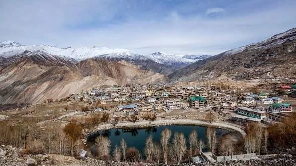
Nako Monastery: Kinnaur's 1,000-Year Cliff Village

November 8, 2026

The 1,000-Year-Old Monastery Hidden Above the Clouds: Inside Nako's Sacred Himalayan Village

Nako is not simply a monastery.

It is a cultural landscape.

Located in the high-altitude Kinnaur region of Himachal Pradesh, the village combines traditional Himalayan settlement, Buddhist religious architecture, mountain geography, and centuries of cultural exchange.

Its monastery complex represents the deep historical connections between the Indian Himalayas and the Tibetan cultural world.

For travelers approaching the settlement, the environment itself is striking. Dry mountains rise above the village, while traditional buildings and religious structures occupy a landscape shaped by altitude, limited resources, and generations of adaptation.

Kinnaur: A Borderland of Cultures

Kinnaur has historically occupied a transitional cultural zone.

Different valleys experienced influences from:

  • Hindu traditions.

  • Tibetan Buddhism.

  • Local Himalayan beliefs.

  • Trade networks.

  • Political powers from neighboring regions.

This diversity is reflected in architecture, language, religious practice, and art.

Nako's Buddhist heritage must therefore be understood within this broader cultural environment.

A Monastic Complex Rather Than a Single Building

The historic religious structures of Nako include multiple temples and sacred spaces.

This is important because a monastery is often a complex rather than a single architectural unit.

Different rooms and buildings may serve different purposes:

  • Prayer halls.

  • Shrines.

  • Meditation spaces.

  • Storage rooms.

  • Residential areas.

  • Smaller chapels.

Over centuries, these spaces may be repaired or rebuilt.

The visible complex therefore represents accumulated history.

The Art of the Himalayan Interior

Like other Himalayan monasteries, Nako's greatest artistic treasures are often located inside rather than outside.

Murals and sculptures can preserve religious traditions extending across centuries.

The interior spaces may contain representations of:

  • Buddhas.

  • Bodhisattvas.

  • Buddhist teachers.

  • Guardians.

  • Celestial figures.

These images transformed the temple into a sacred environment.

The Influence of the Second Diffusion of Buddhism

The development of Buddhist institutions in western Tibet and the Himalayan regions was strongly influenced by a period often described as the “Second Diffusion” of Buddhism.

Following earlier political changes in Tibet, Buddhist institutions underwent processes of revival and reorganization.

New translations were produced.

Monasteries developed.

Teachers traveled across regions.

Nako belongs to this larger historical world.

Village Life and Religious Life

One of the most important aspects of Nako is the close relationship between the monastery and the surrounding community.

A rural Himalayan monastery was not isolated from everyday life.

It could provide:

  • Religious services.

  • Ritual leadership.

  • Festival organization.

  • Education.

  • Cultural continuity.

The monastery was part of the village's social structure.

Building in a Harsh Climate

High-altitude architecture requires adaptation.

Builders had to consider:

  • Cold winters.

  • Limited timber.

  • Snow.

  • Strong sunlight.

  • Earthquake risks.

  • Limited agricultural land.

Traditional construction therefore relied heavily on local materials and accumulated environmental knowledge.

Stone and earth walls provided insulation.

Flat roofs could reflect local climatic conditions.

Buildings were arranged according to available land.

Murals as Historical Documents

A mural can reveal far more than artistic taste.

It may preserve information about:

  • Religious affiliation.

  • Artistic influence.

  • Patronage.

  • Trade connections.

  • Costume.

  • Iconography.

By comparing murals from Nako with those from other Himalayan and Tibetan sites, scholars can trace artistic relationships.

Conservation in a Living Village

Preserving Nako requires balancing several priorities.

The buildings must remain structurally stable.

The artwork must be protected.

But the site must also continue to serve the local community.

This is a common challenge in heritage conservation.

A living monument cannot simply be turned into a museum.

Why Nako Is Historically Important

Nako represents the endurance of Himalayan cultural traditions.

For approximately a millennium, religious practices have remained connected to this high-altitude landscape.

The village demonstrates how communities can preserve cultural identity even under conditions of geographical isolation.

Its monastery is not merely an old building.

It is evidence of continuity.

Generation after generation, people maintained sacred spaces in a landscape where survival itself required cooperation and adaptation.

That combination of environmental resilience and cultural memory makes Nako one of the most fascinating historic landscapes of the Indian Himalayas.

Chitkul: Baspa Valley's Last Inhabited Village

November 8, 2026

The Last Village Before Tibet: Inside Chitkul's Incredible Life at the Edge of the Himalayas

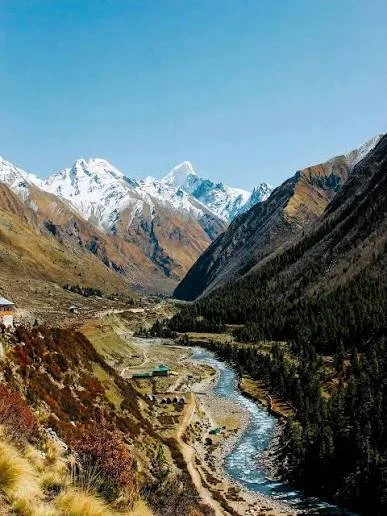
At the far end of the Baspa Valley lies Chitkul, one of the best-known high-altitude villages in Kinnaur.

Popular descriptions often call it the “last inhabited village of India” toward the Tibetan frontier. While the phrase is geographically simplified, it captures something important about the village's cultural identity: Chitkul occupies a dramatic borderland landscape where mountains, rivers, seasonal isolation, and historical trade routes have shaped daily life.

The story of Chitkul is not primarily one of ancient ruins.

It is the story of a living Himalayan settlement.

The Baspa Valley

The Baspa River flows through one of the most dramatic valleys in Kinnaur.

The landscape contains:

  • High mountains.

  • Alpine and subalpine environments.

  • Agricultural terraces.

  • Forests.

  • Glacial systems.

  • Seasonal watercourses.

For centuries, communities had to adapt agricultural and settlement practices to these conditions.

Land was valuable.

Growing seasons were limited.

Winter could isolate villages.

Traditional Architecture

Historic Himalayan villages often developed architecture suited to local environments.

In Kinnaur, traditional structures could combine:

  • Stone.

  • Timber.

  • Mud or earth.

  • Multi-level construction.

Wood and stone could be arranged in ways that provided structural strength and insulation.

Traditional building techniques represent generations of accumulated engineering knowledge.

Agriculture at High Altitude

Life in Chitkul depended on careful use of the short agricultural season.

Communities cultivated crops adapted to local conditions and relied on livestock and other resources.

Agriculture in the Himalayas is rarely a simple matter of planting and harvesting.

It requires:

  • Water management.

  • Terrace construction.

  • Soil preservation.

  • Seasonal planning.

  • Collective labor.

Historical Connections Beyond the Valley

Despite its remote appearance, Chitkul was historically connected to wider networks.

The Himalayan frontier was not an empty barrier.

Mountain passes enabled trade and communication between communities.

Goods, animals, ideas, and cultural practices moved through these routes.

Modern political borders later changed how these landscapes were understood and used.

Religion and Village Identity

Religious traditions remain deeply connected to community life.

Temples, sacred objects, and local rituals provide continuity.

In Himalayan villages, religion is often embedded in the calendar.

Festivals correspond with agricultural cycles.

Rituals can involve local deities.

Community participation reinforces social relationships.

Seasonal Isolation

Winter historically created one of the greatest challenges.

Heavy snow and difficult roads could isolate communities.

This meant that villages had to plan carefully.

Food storage became essential.

Fuel was required.

Buildings had to provide protection.

Seasonality shaped culture.

Tourism and the Modern Transformation

Chitkul's dramatic scenery has increasingly attracted visitors.

Tourism can bring economic opportunities.

But rapid popularity can also create challenges:

  • Waste management.

  • Water pressure.

  • Road development.

  • Changes in traditional architecture.

  • Seasonal overcrowding.

The future of Chitkul therefore depends partly on sustainable development.

Why Chitkul Matters

Chitkul is a reminder that heritage does not exist only in monuments.

A living village can be a historical archive.

Its architecture reflects environmental adaptation.

Its agricultural practices preserve traditional knowledge.

Its location reflects centuries of interaction with the Himalayan landscape.

Chitkul's greatest mystery is not hidden underground.

It is visible every day.

People continue to live in a landscape that has shaped human communities for generations.

Kalpa: Kinnaur's Apple Orchard Temples

November 8, 2026

The Village Beneath a Sacred Mountain: Inside Kalpa's Ancient Temples and Himalayan Apple Kingdom

Kalpa occupies one of the most spectacular settings in Kinnaur.

The village is famous for its views toward the Kinner Kailash range, its apple orchards, and its mixture of Himalayan architectural and religious traditions.

Yet the landscape's beauty can overshadow its historical importance.

Kalpa represents a cultural environment where agriculture, Hinduism, Buddhism, local traditions, and mountain geography developed together.

Kinner Kailash and Sacred Geography

Mountains occupy powerful positions in Himalayan religious thought.

Kinner Kailash is associated with Shiva and forms part of the sacred geography of the region.

The mountain is not simply scenery.

For religious communities, sacred geography creates a relationship between physical landscape and cosmology.

A temple facing a sacred mountain becomes part of a larger religious environment.

Kalpa's Religious Architecture

Traditional temples in Kinnaur often display a mixture of artistic influences.

Wood carving can be especially important.

Architectural forms may reflect local building traditions while incorporating religious symbolism from Hindu and Buddhist worlds.

This blending demonstrates the cultural complexity of Kinnaur.

The Rise of Apple Agriculture

Kalpa is now strongly associated with apple cultivation.

The development of commercial horticulture transformed many Himalayan communities.

Apple orchards created new economic opportunities.

But this transformation also changed landscapes.

Traditional agriculture increasingly interacted with market systems.

Road construction and transport became economically important.

Traditional Farming Before the Apple Economy

Before commercial horticulture dominated many parts of Kinnaur, communities relied on diversified agriculture.

Crops adapted to altitude and climate were cultivated alongside livestock.

This system reduced dependence on a single product.

The growth of apple farming brought prosperity but also increased exposure to market changes and environmental risks.

Architecture and Environmental Adaptation

Kalpa's traditional buildings were designed for mountain conditions.

Stone and timber provided structural and thermal advantages.

Sloping or specialized roof designs responded to local weather.

Buildings reflected both practical engineering and artistic identity.

A Cultural Meeting Point

Kalpa demonstrates that the Himalayas cannot be divided neatly into “Indian” and “Tibetan” cultural zones.

The region contains layers.

Religious traditions overlap.

Languages and artistic styles reveal historical contact.

Trade routes connected communities.

Tourism and Heritage

Kalpa's scenery has made it increasingly important as a tourist destination.

However, tourism creates a conservation challenge.

The very qualities that attract visitors—traditional architecture, orchards, sacred landscapes—can be threatened by uncontrolled development.

Preserving cultural character requires planning.

Why Kalpa Matters

Kalpa represents a Himalayan landscape where economic and spiritual history are inseparable.

The apple orchard is part of modern history.

The temple represents older traditions.

The mountain represents sacred geography.

Together, they create a cultural landscape rather than a collection of separate attractions.

Kalpa shows that heritage is not always hidden in museums.

Sometimes it grows in orchards, survives in wooden temples, and rises above the village in the form of a sacred mountain.

Reckong Peo: Kinnaur's Rock Carvings

November 8, 2026

Ancient Rock Carvings or Forgotten Himalayan History? The Mystery Surrounding Reckong Peo

Reckong Peo, the administrative center of Kinnaur, occupies a strategic position within one of the most culturally complex regions of the Indian Himalayas.

Popular references sometimes associate the wider Kinnaur landscape with ancient carvings, inscriptions, and archaeological traces. However, these claims require careful interpretation. Not every carving or rock marking can automatically be assigned a precise age, and the archaeological documentation of individual sites varies considerably.

What is certain is that Reckong Peo stands within a region shaped by centuries of movement, trade, religious exchange, and adaptation to extreme geography.

Kinnaur as a Historical Corridor

The valleys of Kinnaur connected communities across the Himalayas.

Routes linked:

  • The Indian subcontinent.

  • Tibetan cultural regions.

  • Himalayan valleys.

  • High-altitude pastoral communities.

Movement through these areas was difficult, but difficulty did not prevent exchange.

In fact, mountain routes often became economically and politically important precisely because they provided rare connections through challenging terrain.

Rock Art and the Archaeological Problem

Rock carvings are difficult to interpret.

A mark on stone may be:

  • Ancient art.

  • A religious inscription.

  • A territorial marker.

  • A later historical carving.

  • Modern graffiti.

  • Natural weathering.

Therefore, archaeologists examine context.

Without secure dating or associated archaeological material, assigning a precise age can be difficult.

This uncertainty should not be seen as a weakness.

It is part of responsible archaeology.

Why People Carved Mountains

Across the Himalayas, rocks served as permanent surfaces.

People carved:

  • Religious symbols.

  • Inscriptions.

  • Names.

  • Images.

  • Sacred formulas.

The mountain landscape became a medium for communication.

Reckong Peo and Modern Change

As an administrative and commercial center, Reckong Peo has experienced rapid transformation.

Roads and modern construction have improved connectivity.

However, development can threaten archaeological landscapes.

A carved rock beside an old route may disappear beneath construction.

Documentation is therefore essential.

Sacred Landscape and Kinner Kailash

The town's relationship with the wider Kinner Kailash landscape adds another layer of importance.

Religious geography influences how communities understand place.

Mountains are not empty natural features.

They are connected with stories, deities, pilgrimage, and identity.

Why Reckong Peo Matters

The historical importance of Reckong Peo lies partly in its position.

It stands at the intersection of old and new Kinnaur.

Traditional mountain cultures meet modern administration.

Ancient routes meet modern roads.

Sacred landscapes remain visible alongside rapid development.

The challenge for the future is ensuring that modernization does not erase the archaeological traces that reveal how this Himalayan world developed.

Moorish Alhambra: Granada's Nasrid Palace Secrets

November 8, 2026

The Alhambra's Hidden Secrets: How the Last Muslim Rulers of Spain Built a Palace That Still Defies Time

Few monuments in the world combine architecture, political history, mathematics, poetry, water engineering, and artistic imagination as completely as the Alhambra.

Rising above Granada in southern Spain, the complex was developed primarily under the Nasrid dynasty, the last major Muslim ruling house of al-Andalus.

To describe the Alhambra simply as a palace is inadequate.

It was a royal city.

A fortress.

An administrative center.

A collection of gardens.

A symbolic representation of power.

And, after the Christian conquest of Granada in 1492, a monument that continued to acquire new architectural layers.

The Nasrid Kingdom of Granada

By the thirteenth century, Islamic political control in much of the Iberian Peninsula had been reduced dramatically.

The Nasrid Emirate of Granada survived as the final major Muslim state on the peninsula.

Its rulers faced powerful Christian kingdoms.

Diplomacy, tribute, military strategy, and political alliances became essential to survival.

The Alhambra emerged as the architectural heart of this kingdom.

From Fortress to Palace City

The name Alhambra derives from the Arabic al-Qal'a al-Hamra, often translated as “the Red Fortress.”

The site had earlier fortifications, but the Nasrid rulers transformed the hill into a major royal complex.

Its development included:

  • Defensive walls.

  • Towers.

  • Palaces.

  • Administrative spaces.

  • Gardens.

  • Water systems.

  • Mosques and later churches.

  • Residential areas.

Water: The Secret Engineering of the Alhambra

One of the most remarkable features of the complex is water.

Water flows through channels.

It fills pools.

It reflects architecture.

It cools courtyards.

It creates sound.

But its presence required sophisticated engineering.

Water had to be transported uphill and distributed throughout the complex.

The resulting system was both practical and symbolic.

In Islamic garden traditions, flowing water could evoke images of paradise.

The Geometry of Islamic Decoration

The Alhambra's walls appear covered with endlessly repeating patterns.

These designs are not random.

Artists used principles of geometry and symmetry to create complex visual systems.

Patterns could repeat indefinitely.

Stars, polygons, and interlocking forms created the impression of infinite order.

The result demonstrates a sophisticated relationship between mathematics and artistic design.

Arabic Inscriptions Everywhere

The Alhambra is also a palace of writing.

Arabic calligraphy appears throughout the complex.

Some inscriptions contain religious expressions.

Others include poetry.

Still others repeat royal mottos.

The most famous Nasrid phrase is:

“Wa la ghalib illa Allah” — “There is no victor but God.”

The repeated inscription linked political authority with divine power.

The Court of the Lions

The Court of the Lions is one of the Alhambra's most famous spaces.

At its center stands a fountain supported by twelve sculpted lions.

The courtyard combines architecture, water, geometry, and symbolism.

The surrounding palace spaces create an environment designed for elite life.

But interpreting the exact symbolism of the lions has generated considerable scholarly discussion.

The monument should therefore be appreciated not as a puzzle with one secret answer, but as a space whose meanings developed through multiple historical contexts.

The Fall of Granada

In 1492, Granada surrendered to the Catholic Monarchs Ferdinand and Isabella.

The conquest marked the end of the Nasrid state.

But the Alhambra was not destroyed.

Instead, it was transformed.

Christian rulers occupied and altered portions of the complex.

Later, Charles V commissioned a Renaissance palace within the wider Alhambra complex.

This produced one of the monument's most striking characteristics: multiple civilizations remain physically visible in the same place.

Romanticism and the Rediscovery of the Alhambra

Centuries later, European Romantic writers and artists became fascinated by the monument.

Washington Irving's Tales of the Alhambra helped popularize the site internationally.

However, Romantic fascination sometimes transformed the real history of the monument into fantasy.

The Alhambra became associated with exoticized images of the “Orient.”

Modern scholarship attempts to move beyond these stereotypes.

Why the Alhambra Matters

The Alhambra is one of humanity's greatest architectural achievements because it demonstrates that beauty can emerge from systems.

Water is engineered.

Geometry is calculated.

Poetry becomes architecture.

Light becomes part of design.

The Nasrid rulers built their palace during a period when their kingdom faced enormous political pressure.

Yet instead of producing only military structures, they created one of the most sophisticated artistic environments in world history.

The Alhambra remains proof that even a kingdom approaching its political end can produce cultural achievements that survive for centuries.

Sigtuna: Sweden's Medieval Town Foundation

November 8, 2026

Introduction

Sigtuna occupies a special position in the history of medieval Scandinavia. Founded in the late 10th century, it became one of the earliest planned urban settlements in what is now Sweden and developed into an important center of royal authority, Christianity, trade, craftsmanship, and administration.

Unlike the older agricultural settlements and aristocratic centers that dominated much of Iron Age Scandinavia, Sigtuna represented a different type of community. It was deliberately established as a town, with a concentration of inhabitants, workshops, merchants, religious institutions, and administrative functions.

Its emergence occurred during a period of profound transformation. Scandinavia was moving from the decentralized social structures of the Viking Age toward increasingly centralized kingdoms. Christianity was spreading, rulers were strengthening their authority, and commercial networks were connecting Scandinavia with the Baltic, eastern Europe, and the wider European world.

Sigtuna therefore provides archaeologists with evidence for the moment when Scandinavian society began developing recognizable medieval urban institutions.

The Foundation of Sigtuna

Sigtuna was established around the end of the 10th century, traditionally associated with King Erik Segersäll or the early Swedish royal dynasty, although the precise circumstances of its foundation remain debated.

Its location was strategically important.

The settlement stood on the shores of Lake Mälaren, within a water-based transportation system that connected the interior of Sweden with the Baltic Sea.

Before the development of extensive medieval road networks, waterways were among the most efficient means of transportation.

Sigtuna's position allowed goods, people, information, and political influence to move through the region.

The town was therefore not simply established because the landscape was convenient for settlement. Its location made it useful for economic and political purposes.

A New Kind of Scandinavian Settlement

Earlier Scandinavian communities could be large and influential without functioning as towns.

Royal halls, market sites, farms, and seasonal trading locations existed throughout the Viking world.

Sigtuna was different because permanent urban functions became concentrated in one location.

People could specialize in particular occupations rather than relying entirely on farming.

Archaeological excavations have revealed evidence for:

  • metalworking;

  • bone and antler working;

  • textile production;

  • leatherworking;

  • woodworking;

  • trade;

  • food preparation;

  • religious activity.

This concentration of specialized production indicates an increasingly complex economy.

Sigtuna and the Christianization of Sweden

Sigtuna developed during the same period in which Christianity was becoming increasingly influential in Scandinavia.

Christianization was not an instantaneous process.

Traditional religious beliefs continued alongside Christianity for generations, and archaeological evidence suggests that religious transformation occurred gradually.

Sigtuna nevertheless became an important Christian center.

Churches were established in and around the town, and Christian burial practices increasingly replaced older traditions.

The town's religious institutions also helped connect Sweden with Christian Europe.

Clergy, missionaries, merchants, and travelers carried new religious ideas into Scandinavia.

Christianity also introduced new forms of literacy, administration, architecture, and international communication.

The Sigtuna Runestones

One of the most remarkable features of Sigtuna is its connection with runic writing.

Runestones were not merely decorative monuments.

They could commemorate the dead, proclaim social relationships, record journeys, or express religious identity.

Sigtuna's runic evidence is especially valuable because it reflects a society undergoing rapid transformation.

Some inscriptions preserve names and personal relationships that would otherwise have disappeared from the historical record.

They demonstrate that ordinary individuals, craftsmen, merchants, warriors, and political figures participated in a literate culture even before Latin writing became dominant.

Coinage and the Growth of a Monetary Economy

Sigtuna is particularly important for the history of Scandinavian coinage.

The town became associated with some of Sweden's earliest coin production.

Coins represented more than money.

They were also instruments of political authority.

A ruler who issued coins could place his name and symbols into everyday economic transactions.

Coinage therefore helped communicate royal power.

The emergence of local minting also demonstrates that Sigtuna had developed an economy sufficiently sophisticated to support standardized currency.

International Trade

Sigtuna was connected to the broader commercial networks of the Viking and medieval worlds.

Archaeological discoveries demonstrate contact with regions extending far beyond central Sweden.

Imported materials and objects indicate connections with the Baltic, eastern Europe, and western European markets.

Merchants could exchange:

  • furs;

  • iron;

  • textiles;

  • wax;

  • amber;

  • imported ceramics;

  • glass;

  • metal goods;

  • luxury objects.

The town therefore participated in a much larger economic system.

Craftsmen and Urban Production

Craft specialization was one of the defining characteristics of Sigtuna.

Archaeological layers contain waste products associated with manufacturing.

Metalworking remains include slag, fragments, tools, and production debris.

Bone and antler workers produced handles, combs, decorative objects, and other useful items.

Textile production required spinning, weaving, dyeing, and sewing.

Leatherworkers manufactured shoes, straps, bags, and other products.

The concentration of these activities suggests that Sigtuna was not simply a residence for merchants and elites.

It was a productive urban community.

Houses and Streets

Archaeological excavations have revealed evidence of planned settlement organization.

Buildings were often arranged along plots or streets rather than being scattered randomly across the landscape.

Houses were primarily constructed from wood, making them vulnerable to decay, fire, and rebuilding.

Consequently, modern archaeologists frequently reconstruct the history of the town through postholes, floor surfaces, hearths, wells, refuse pits, and layers of occupation.

Repeated rebuilding created complex archaeological stratigraphy.

A single location could contain evidence from several generations.

Everyday Life

Sigtuna's inhabitants experienced a mixture of urban and rural life.

Although agriculture remained essential, townspeople increasingly relied on commercial exchange for certain goods.

Food remains provide evidence of diets based on grains, meat, fish, dairy products, and locally available resources.

Animals also played an important role in transportation, food production, and craft industries.

The town would have been noisy and active.

Smiths hammered metal.

Merchants negotiated transactions.

Woodworkers constructed objects.

Children played around houses and streets.

Travelers arrived by boat.

Religious ceremonies brought communities together.

The archaeological record transforms Sigtuna from an abstract historical name into a living settlement.

Social Hierarchy

Sigtuna was not an egalitarian community.

Social differences can be identified through housing, burial practices, imported goods, and access to valuable materials.

Royal and aristocratic interests were particularly important.

The town's connection with early Swedish kings suggests that political authority played a major role in its development.

At the same time, merchants and craftsmen possessed specialized knowledge that gave them economic importance.

Urban society therefore consisted of multiple social groups whose interests sometimes overlapped and sometimes competed.

Sigtuna's Political Importance

The town became an important center of emerging Swedish state formation.

Royal authority required places where taxes could be collected, goods exchanged, officials could operate, and political messages could circulate.

Sigtuna provided precisely such an environment.

Its development illustrates the broader transformation of Scandinavian kingship.

Instead of authority being based primarily on personal relationships between a ruler and local elites, medieval kingdoms increasingly depended upon institutions, towns, churches, taxation, and administration.

Archaeology and the Reconstruction of Sigtuna

Because so little medieval architecture survives above ground, archaeology is essential.

Excavations have recovered enormous quantities of material.

These include:

  • pottery;

  • animal bones;

  • metal objects;

  • coins;

  • glass;

  • textiles;

  • combs;

  • tools;

  • weapons;

  • building remains;

  • runic inscriptions.

Each object contributes a small piece to the history of the town.

A broken comb may reveal local craftsmanship.

A coin may indicate trade or political connections.

A foreign object may demonstrate long-distance exchange.

A piece of animal bone may reveal dietary practices.

Archaeology therefore allows historians to reconstruct aspects of Sigtuna that written sources never recorded.

Sigtuna's Medieval Legacy

Sigtuna remained an important settlement after the Viking Age.

Christian institutions became increasingly established, and the town continued to participate in regional commerce.

Its historical importance eventually became overshadowed by larger Swedish urban centers, particularly Stockholm, but Sigtuna remained a significant settlement.

Its early foundation nevertheless makes it one of the most important archaeological sites for understanding Sweden's transition into the medieval period.

Conclusion

Sigtuna was more than an early Swedish town.

It was a manifestation of a changing Scandinavian world.

Its streets brought together craftsmen, merchants, religious specialists, travelers, political authorities, and ordinary families. Its workshops demonstrate increasing economic specialization. Its churches reveal the spread of Christianity. Its coins reflect emerging royal institutions. Its runestones preserve individual voices from a period of enormous social transformation.

The town's greatest importance lies in what it represents.

Sigtuna shows how Scandinavia moved from the decentralized communities of the Viking Age toward an increasingly urban, Christian, monetized, and politically centralized medieval society.

Beneath its modern streets lie the remains of one of the foundations upon which medieval Sweden was built.

Gamla Uppsala: Sweden's Royal Mound Cemetery

November 8, 2026

Introduction

Few archaeological landscapes in Scandinavia possess the symbolic power of Gamla Uppsala.

Located in central Sweden, Gamla Uppsala became one of the most important political and religious centers of pre-Christian Scandinavia. Its enormous burial mounds, ceremonial landscape, royal associations, and later Christian history combine to create one of the richest archaeological environments for understanding early Swedish society.

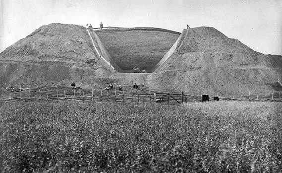
The most famous monuments are the monumental burial mounds traditionally known as the Royal Mounds.

Rising dramatically from the surrounding landscape, they demonstrate the ability of Iron Age communities to organize enormous amounts of labor for commemorative and political purposes.

Gamla Uppsala was not simply a cemetery.

It was a center of power.

The Royal Mounds

The three largest mounds dominate the archaeological landscape.

They are generally associated with the Migration Period and Vendel Period, although their precise dates and identities remain subjects of scholarly investigation.

The construction of such monuments required enormous labor.

Earth and other materials had to be collected and transported.

The mound had to be carefully constructed around the burial.

Its impressive size ensured that the deceased remained physically and visually connected with the surrounding landscape.

Monumental burial therefore served both religious and political purposes.

Royal Burial and Social Power

Burial mounds were expressions of status.

A modest burial could communicate one social position, while a monumental mound communicated another.

At Gamla Uppsala, the scale of the monuments indicates access to substantial resources.

The individuals buried beneath them were probably members of an elite with significant political influence.

However, archaeologists cannot simply assume that every mound contained a king.

The exact identities of the people buried within the largest mounds remain uncertain.

This uncertainty is important because archaeology distinguishes between evidence and later tradition.

Gamla Uppsala as a Political Center

The site appears to have been more than a burial ground.

Archaeological investigations have identified evidence of substantial settlement and large halls.

Such buildings could accommodate feasting, political gatherings, ceremonies, and elite activities.

Feasting was an important mechanism of political authority.

A powerful leader could demonstrate generosity by distributing food and drink.

Guests could establish alliances through shared meals.

Political loyalty could therefore be strengthened through hospitality.

Religious Significance

Gamla Uppsala became closely associated with pre-Christian Scandinavian religion.

Medieval written sources describe a major pagan sanctuary in the region.

One famous account describes a temple containing images of gods such as Thor, Odin, and Freyr.

However, these descriptions were written after Scandinavia had become Christian and must therefore be interpreted cautiously.

Archaeology cannot independently confirm every detail described in medieval texts.

Nevertheless, the combination of monumental burial, elite settlement, ceremonial structures, and landscape organization strongly suggests that religious activities were important at Gamla Uppsala.

Sacrifice and Ritual

Animal remains from the broader archaeological environment have provided evidence relevant to ritual activity.

Animals were important in Scandinavian religious practices.

Sacrificial ceremonies could involve cattle, horses, pigs, sheep, and other animals.

Their remains may appear in unusual archaeological contexts.

Such discoveries help archaeologists investigate whether certain areas were used for ritual rather than ordinary food consumption.

Religion was therefore deeply integrated with political and economic life.

The Landscape as a Monument

One of Gamla Uppsala's greatest characteristics is its landscape.

The mounds were not isolated monuments.

They existed within a broader ceremonial environment.

Roads, buildings, open spaces, burial areas, and natural features interacted with one another.

The placement of monuments influenced how people moved through the landscape.

A visitor approaching the site would have encountered the mounds as enormous visual statements.

The landscape communicated permanence, ancestry, and authority.

Feasting Halls

Large halls were central to elite Scandinavian society.

A hall could serve as a political headquarters, ceremonial space, dining area, and residence.

The architecture itself could communicate status.

Large wooden structures required substantial resources and skilled construction.

Within the hall, social hierarchy could be physically represented through seating arrangements.

The ruler or leading figure occupied a prominent position.

Feasting therefore combined architecture, food, gift exchange, storytelling, and political negotiation.

Connections With the Wider Scandinavian World

Gamla Uppsala was part of extensive networks.

Goods, ideas, artistic styles, and people moved across Scandinavia and the Baltic region.

Objects discovered at elite sites can sometimes be linked to distant manufacturing traditions.

This demonstrates that early Swedish elites were not isolated.

They participated in international networks that connected Scandinavia with continental Europe and the eastern Baltic.

Christianity and Transformation

The history of Gamla Uppsala continued after the conversion of Sweden.

Christian institutions were established at the site.

The medieval church became an important symbol of the transformation of Swedish society.

The old religious landscape was not simply erased.

Instead, Christian institutions emerged within a landscape already loaded with political and cultural significance.

This process illustrates how Christianization could involve both replacement and adaptation.

The Archaeological Importance of Gamla Uppsala

Modern archaeology has transformed our understanding of the site.

Excavations have revealed settlement remains, craft activity, animal bones, burial evidence, and architectural structures.

Geophysical surveys have also helped identify buried features without excavating everything.

These techniques allow researchers to reconstruct the settlement on a much larger scale.

The result is a picture of a complex center rather than a simple cemetery.

Myth, Memory, and History

Gamla Uppsala occupies an unusual position between archaeology and mythology.

Later traditions associated the site with legendary Swedish kings and gods.

Such traditions cannot automatically be treated as literal historical records.

However, they remain historically significant because they demonstrate how later generations remembered the landscape.

Places of political importance often accumulate stories.

The landscape becomes a repository of collective memory.

Conclusion

Gamla Uppsala represents one of the most important archaeological landscapes of Iron Age Scandinavia.

Its monumental mounds demonstrate elite power.

Its halls reveal political and social organization.

Its ritual evidence illustrates the importance of religion.

Its later Christian history shows how dramatically Scandinavian society changed.

Above all, Gamla Uppsala demonstrates that landscapes themselves could become instruments of power.

The great mounds were visible declarations that important ancestors had lived, ruled, and been remembered.

For centuries, their presence helped preserve the memory of an earlier Scandinavian world.

Letsie: Lesotho's Royal Kraal Ruins

November 8, 2026

Introduction

The name Letsie occupies an important place in the history of Lesotho because several members of the Basotho royal family carried the name, most notably King Letsie I and the modern King Letsie III. A title such as Letsie: Lesotho's Royal Kraal Ruins therefore immediately evokes the relationship between royal authority, settlement, architecture, and the historical landscape of the Basotho kingdom.

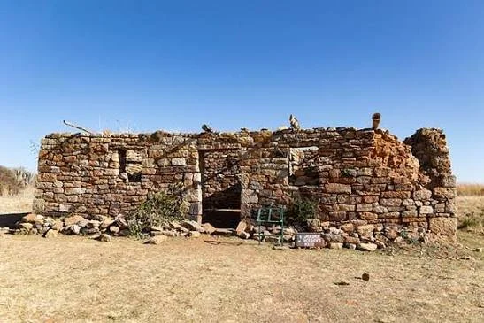
The term "royal kraal" should be used carefully. A kraal traditionally refers to an enclosed settlement or livestock enclosure, and royal compounds could contain residential, administrative, ceremonial, and defensive spaces. However, not every ruined stone enclosure associated with a royal name can automatically be identified as a royal residence.

The study of such places is valuable because the history of Lesotho is preserved not only in written documents but also in settlement patterns, stone architecture, oral traditions, and landscapes associated with chiefly and royal authority.

Royal Settlement in Basotho History

The Basotho kingdom emerged during a period of profound political transformation in southern Africa.

Moshoeshoe I established his authority during the nineteenth century, bringing together communities that had experienced warfare, displacement, migration, and political instability.

Royal settlements became important centers of administration.

They were places where political decisions were made, visitors received, disputes negotiated, livestock managed, and relationships between communities maintained.

A royal settlement was therefore much more than a house.

The Kraal as a Social Institution

The traditional kraal had multiple functions.

Livestock enclosures were economically essential because cattle, sheep, goats, and horses represented wealth and security.

Residential structures were often organized around social relationships.

The arrangement of buildings and open spaces could communicate hierarchy.

A chiefly or royal kraal could consequently become a physical expression of political authority.

Its architecture reflected the organization of society.

Stone Architecture in Lesotho

Lesotho's mountainous environment encouraged extensive use of locally available stone.

Stone walls could serve many purposes.

They could define compounds, protect livestock, divide agricultural land, support terraces, or provide defensive barriers.

Over time, abandoned settlements could become difficult to distinguish from ordinary agricultural structures.

This creates an important challenge for archaeologists.

The historical identity of a site cannot be established from stonework alone.

Oral History

Royal and chiefly landscapes are particularly suitable for combining archaeology with oral history.

Local communities may preserve names for hills, springs, ruins, graves, fields, or former settlements.

Such names can provide clues about historical occupation.

Oral traditions may also explain why a particular settlement was important.

However, oral traditions can change over generations.

Researchers therefore compare them with genealogies, written records, archaeological evidence, and historical maps.

The Meaning of Ruins

Ruins are not simply abandoned buildings.

They are evidence of changing political geography.

A royal settlement may decline because a ruler moves elsewhere, political circumstances change, population patterns shift, or economic priorities change.

The abandonment of a royal kraal therefore does not necessarily represent political collapse.

It may reflect the normal movement of a royal household.

Archaeological Research

Research at a possible royal kraal would examine:

  • wall construction,

  • foundations,

  • domestic structures,

  • livestock enclosures,

  • pottery,

  • metal objects,

  • hearths,

  • agricultural terraces,

  • burial areas,

  • and landscape relationships.

Dating would be particularly important.

A stone wall could belong to several different periods.

Heritage Protection

Royal sites are also important cultural heritage resources.

Uncontrolled construction, erosion, stone removal, agriculture, and tourism can damage archaeological remains.

Recording the location and condition of ruins helps preserve historical information.

Community participation is particularly important because local residents often possess knowledge unavailable in formal archives.

Conclusion

Letsie: Lesotho's Royal Kraal Ruins provides a useful framework for examining how Basotho political authority became embedded in physical landscapes.

A specific ruin should not be labeled a royal residence solely because of its name.

Instead, archaeology, oral history, genealogy, historical documents, and architectural analysis must be combined.

The broader significance of royal kraals lies in what they reveal about Basotho society: political power was expressed through settlement, livestock, family networks, hospitality, landscape, and the organization of everyday life.

The Archaeology of Mudbrick Reinforcement: Straw, Hair and Other Fibres

November 8, 2026

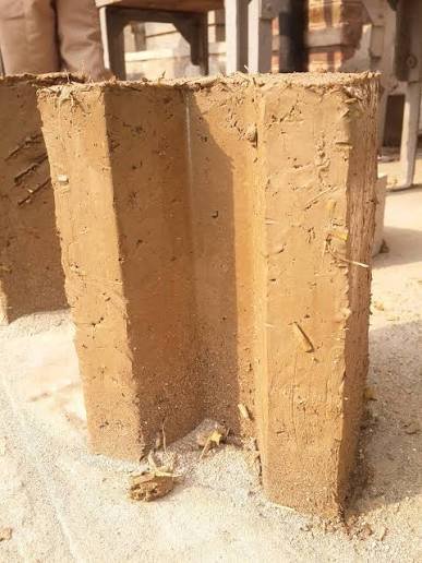
Mudbrick was one of the most widely used building materials in many ancient societies. Made primarily from earth mixed with water and shaped into blocks, mudbrick offered an accessible construction method in regions where suitable stone was scarce or expensive. Although relatively simple to produce, mudbrick buildings required an understanding of soil composition, moisture, drying conditions, and structural stability. Builders sometimes incorporated plant fibers or other organic materials into earthen mixtures to improve their handling properties and reduce certain forms of cracking. The archaeological study of these reinforcements can reveal how communities developed practical construction knowledge and adapted building materials to local environments.

The performance of mudbrick depends on the properties of the soil used to make it. Clay particles help bind the mixture, while sand and other mineral grains influence its texture and shrinkage during drying. A mixture containing too much clay may shrink substantially and develop cracks, whereas a mixture with insufficient binding material may crumble easily. Builders therefore needed to select and combine available earth materials according to their intended use. The addition of fibers could further influence the behavior of the brick by distributing stresses, limiting some cracks, and improving the cohesion of the material as it dried.

Straw is among the best-known reinforcements used in earthen construction. Plant stems can be mixed into wet mudbrick material, creating a network of fibers within the finished block. These fibers may help reduce the development or widening of shrinkage cracks by bridging small separations in the earth matrix. They can also influence the brick's density, texture, and drying behavior. The effectiveness of straw depends on factors such as fiber length, quantity, distribution, and the properties of the surrounding soil. Excessive organic material may weaken the block or create voids as it decomposes, so the mixture must balance workability with structural performance.

Other plant materials could also be used, depending on regional availability. Chopped grasses, reeds, chaff, and other agricultural by-products may have served as reinforcement or as components of a workable earthen mixture. The use of such materials could link construction directly to farming practices, allowing households to reuse residues from harvesting and food processing. Archaeologists may investigate the presence of plant fibers through microscopic analysis of surviving bricks. However, not every plant fragment represents deliberate reinforcement. Seeds, roots, and other organic remains can enter mudbrick accidentally when soil is collected from agricultural fields or disturbed ground.

Animal hair is another possible fiber material, although its use must be demonstrated for each archaeological context rather than assumed. Hair can be incorporated into some construction mixtures, but it is less consistently documented than plant-based reinforcement in many earthen building traditions. If animal hair is identified within a mudbrick, researchers need to determine whether it was intentionally added or introduced accidentally through animal activity, contaminated soil, or later biological processes. Microscopic examination may reveal features of the fibers, while chemical or protein-based methods could potentially support identification where preservation allows. Even a reliable identification of hair does not by itself establish the reason for its inclusion.

Archaeological analysis begins with examining the structure and composition of the brick. Researchers may record its dimensions, color, density, surface texture, and visible inclusions. Thin-section micromorphology allows the internal structure of a small sample to be examined under a microscope, revealing mineral grains, pores, plant fragments, and the relationships between these components. This can help distinguish fibers distributed throughout the original mixture from organic material that entered through cracks or later deterioration. The arrangement of fibers may also provide clues about mixing methods and manufacturing practices, although the precise sequence of preparation may remain uncertain.

The preservation of organic reinforcement varies greatly. Plant fibers may survive as recognizable fragments in dry environments, but they often decay in damp soils. In some cases, the original fiber disappears while leaving a void or impression within the brick. Charred fibers may survive under conditions that destroy unburned material, although burning can alter their microscopic characteristics. Animal hair and other protein-based materials may also deteriorate or become chemically altered. As a result, the absence of visible fibers does not prove that builders never used reinforcement, especially at sites where preservation conditions were unfavorable.

Experimental archaeology can help explain how different fibers affect mudbrick performance. Researchers can prepare replica bricks using locally appropriate soil mixtures and vary the type, length, and quantity of added fibers. By observing drying times, shrinkage, cracking, resistance to handling, and responses to moisture, experiments can test the practical effects of different recipes. Such work can also help distinguish fibers added to improve construction performance from materials that were present incidentally. Nevertheless, modern experiments cannot reproduce every ancient production process, and results should be compared with archaeological specimens rather than used as a substitute for direct evidence.

The use of agricultural residues in construction may reveal relationships between household economies and building maintenance. Straw and other plant materials could be readily available after harvest, making them convenient additions to bricks and plaster. The choice of reinforcement may therefore reflect seasonal resource availability as well as technical preferences. In some communities, construction practices may have been passed between generations through practical experience rather than formal instruction. Similar recipes across neighboring settlements could indicate shared knowledge, while differences may reflect local soils, climate, building traditions, or access to materials.

Mudbrick reinforcement also has implications for the study of ancient architecture and conservation. The composition of a brick influences how it responds to rainfall, humidity, temperature changes, and structural loads. Understanding the original mixture can help explain why certain walls survived while others eroded rapidly. It can also inform conservation strategies, since modern repairs that use incompatible materials may cause additional damage. Preserving surviving mudbrick requires attention to drainage, moisture control, protective coverings, and the chemical and physical compatibility of replacement materials.

The archaeology of mudbrick reinforcement shows how seemingly simple construction materials can embody sophisticated practical knowledge. Straw and other fibers could help builders manage shrinkage, improve workability, and make effective use of locally available resources. Animal hair and less common reinforcements remain possibilities that require careful identification and contextual support. By combining microscopic analysis, material characterization, experimental archaeology, and environmental study, researchers can investigate how ancient builders designed their mixtures and maintained their structures. These findings contribute to a broader understanding of technological adaptation, agricultural reuse, and the everyday knowledge that sustained earthen architecture across many regions and periods.

The Archaeology of Salt-Encrusted Amphorae from Storm Wrecks

November 8, 2026

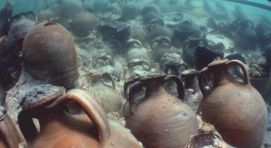
Amphorae were widely used in the ancient Mediterranean and neighboring regions to transport commodities such as wine, olive oil, fish products, and other liquids or preserved foods. Their distinctive shapes, handles, and narrow necks made many types suitable for stacking and handling during maritime transport. When ships sank during storms, their cargoes could be buried beneath sediment or scattered across the seabed. In some underwater environments, amphorae become coated with salt deposits or mineral crusts that obscure their surfaces and complicate identification. The archaeology of salt-encrusted amphorae examines how these objects can reveal ancient trade, shipwreck formation, cargo handling, and the preservation processes that occur underwater.

Shipwrecks can form when vessels encounter storms, navigational hazards, structural failures, or other maritime dangers. Storms may push ships toward reefs, cliffs, shallow shoals, or exposed coastlines, where waves and currents can destroy the vessel and disperse its cargo. The final arrangement of a wreck depends on many factors, including the depth of the water, the strength and direction of currents, the shape of the seabed, and the construction of the ship. A concentration of amphorae may represent a largely intact cargo, while a broad scatter of vessels may indicate extensive post-wreck movement. Archaeologists must reconstruct these processes before using artifact distribution to infer how the ship sank.

The term "salt-encrusted" can refer to several different forms of surface accumulation. Seawater contains dissolved salts, but not every crust found on an underwater artifact consists of simple salt crystals. Mineral deposits, biological growth, corrosion products, sediment cementation, and combinations of these processes can form hard layers over amphora surfaces. The composition of the crust depends on the water chemistry, surrounding sediment, temperature, biological activity, and the material from which the vessel was made. Scientific analysis is therefore necessary to distinguish soluble salts from other mineral or biological deposits.

Ceramic amphorae are generally more resistant to corrosion than metal objects, but their surfaces can still be altered underwater. Salt crystallization may occur when dissolved salts move into pores and later crystallize as moisture conditions change, particularly during recovery and drying. These crystals can exert pressure within the ceramic body and contribute to surface flaking or cracking. Mineral crusts may also conceal painted marks, inscriptions, potter's stamps, manufacturing details, and traces of the original contents. Conservation specialists must therefore consider the risks of removing deposits too aggressively, since cleaning can damage information that has survived for centuries.

The shape and manufacture of amphorae provide important evidence for identifying their origins and functions. Different production centers developed distinctive vessel forms, clay recipes, handles, rims, bases, and surface treatments. Archaeologists can compare these characteristics with known typologies to estimate a vessel's date and place of manufacture. Petrographic and chemical analyses may help determine the geological origin of the clay. However, typological similarities do not always prove that two vessels came from the same workshop, and local imitations can resemble imported forms. The strongest identifications combine visual examination with material analysis and archaeological context.

Residue analysis can help identify what amphorae originally contained. Organic compounds preserved within the ceramic fabric may provide evidence of wine, plant oils, fish products, or other substances, depending on preservation and analytical methods. Researchers may use techniques such as gas chromatography and mass spectrometry to examine chemical residues. Yet the interpretation of residues is not always straightforward. A vessel could have been reused, contaminated during burial, or exposed to substances after the shipwreck. A single chemical marker rarely establishes the original cargo with certainty, so residue results should be compared with vessel type, associated artifacts, and the broader wreck context.

Cargo arrangement can reveal how a ship was loaded and operated. Amphorae were often transported in groups, sometimes packed into spaces within the hull to reduce movement during a voyage. The positions of surviving vessels may help researchers reconstruct the cargo hold and estimate the scale of the shipment. Differences in amphora types could indicate mixed cargoes, multiple suppliers, or successive loading events. However, the present distribution of objects may not reflect the original arrangement because storms, currents, scavenging, and later human activity can displace artifacts. Careful mapping and documentation are essential before reconstructing the ship's cargo.

The presence of salt crusts may also provide information about the post-depositional history of a wreck. Deposits can form or change after an amphora reaches the seabed, influenced by the chemistry of the surrounding water and the movement of sediment. In some cases, a thick crust may conceal an older surface, while in others it may consist largely of material accumulated after the wreck. Researchers can examine the mineral composition and structure of the deposits to investigate how they developed. Such studies help distinguish evidence associated with the original voyage from changes that occurred after the vessel sank.

Storm wrecks can preserve evidence of the human and economic networks that connected coastal communities. Amphorae manufactured in one region might have been transported through several ports before reaching their destination. A wreck containing vessels from multiple production centers could reflect a complex commercial system rather than a single direct route. Other artifacts, such as anchors, ship fittings, cooking vessels, coins, and personal belongings, may help identify the vessel's operating environment. Still, the exact destination of a ship is not always recoverable from its cargo, because merchants could change plans or transfer goods between vessels during a journey.

Conservation is a critical part of underwater amphora research. Objects recovered from the sea may carry salts deep within their porous structure. If they are allowed to dry rapidly without appropriate treatment, salt crystallization can damage the ceramic. Conservators therefore assess the material, document the condition of the crust, and choose cleaning and desalination procedures suited to the object. Some deposits may be retained if they contain useful information or protect fragile surfaces. Decisions about cleaning must balance the need to identify the amphora with the responsibility to preserve its archaeological evidence.

The archaeology of salt-encrusted amphorae from storm wrecks brings together maritime archaeology, ceramic studies, chemistry, and conservation science. Amphorae can reveal the transport of foodstuffs and other commodities, while their surface deposits provide evidence about the conditions in which shipwrecks were buried and preserved. By combining detailed mapping, typological study, residue analysis, material characterization, and careful conservation, researchers can reconstruct aspects of ancient trade and maritime activity. Each vessel is more than a container recovered from the seabed; it is a surviving component of a commercial journey whose route, cargo, and final disaster can be investigated through the evidence it retains.

Ancient Salt Trade Along Mountain Passes: Camps and Relays

November 8, 2026

Introduction

Salt has been an essential resource throughout human history. It was used to preserve food, support human and animal health, process hides, and serve various domestic and industrial purposes. Because natural salt deposits were unevenly distributed, communities often depended on exchange networks to obtain it.

Mountain passes were particularly important in the movement of salt between production areas and inland settlements. Although transporting heavy loads through mountainous terrain was difficult, established routes could connect salt sources with agricultural communities, pastoral regions, and urban markets.

The archaeology of salt trade along mountain passes offers a way to investigate transportation systems, temporary camps, exchange points, and the economic relationships that developed around an essential mineral resource.

The Importance of Salt in Ancient Societies

Salt is primarily composed of sodium chloride and occurs naturally in several forms, including rock salt, saline springs, and evaporated seawater.

Its importance extended beyond seasoning food. Salt could help preserve meat and fish, allowing communities to store food for longer periods and transport it over greater distances.

It was also used in certain craft activities, including hide processing and food preparation. Livestock required access to mineral salts as part of their nutritional needs.

Because of these uses, salt could become an important commodity in both local and long-distance exchange.

Sources of Ancient Salt

Ancient communities obtained salt from different geological and environmental sources.

Rock salt deposits could be mined from underground formations or exposed mineral beds. Saline springs and salt lakes provided another source, while coastal communities could produce salt through the evaporation of seawater.

The method of production depended on local geography and climate.

Salt production sites could range from small-scale household operations to larger installations involving evaporation basins, heating equipment, storage areas, and organized labor.

The location of these sources influenced the direction and cost of trade routes.

Why Mountain Passes Were Important

Mountain ranges can separate communities that depend on different resources. A valley with productive agricultural land may lack salt, while a nearby geological region contains valuable deposits.

Mountain passes provide routes through otherwise difficult terrain. They connect valleys, plateaus, and neighboring ecological zones.

A pass could therefore become an important corridor for transporting salt and other goods.

The most useful routes were not necessarily the shortest. Traders needed paths with manageable slopes, reliable water sources, access to grazing, and places where animals and people could rest.

Camps and Relay Stations

Long-distance transport through mountains required places where travellers could stop, rest, and reorganize their loads.

Temporary camps might have been established near springs, sheltered valleys, or relatively level sections of a route.

These camps could contain hearths, simple shelters, animal enclosures, storage areas, and discarded equipment.

Relay stations offered another possible arrangement. Goods could be transferred between groups or animals at intermediate points, reducing the need for one team to complete the entire journey.

However, the presence of a temporary camp along a mountain route does not automatically establish a connection with salt trading. Its function must be supported by evidence such as salt residues, transport equipment, associated production sites, or historical documentation.

Transporting Salt Through Mountain Landscapes

Salt was a valuable but relatively heavy commodity. Transport methods varied according to the region, available animals, road conditions, and the scale of trade.

Pack animals such as donkeys, mules, horses, and camels could carry loads along established routes. In some areas, human porters may also have transported salt in baskets or containers.

The packaging of salt was important because moisture could cause it to dissolve or become difficult to handle. Traders needed suitable containers, sacks, baskets, or other protective materials.

The remains of these containers may survive archaeologically, although organic packaging is often poorly preserved.

Archaeological Evidence for Salt Trade

Salt itself can be difficult to identify in archaeological deposits because it is highly soluble and may disappear through contact with water.

Researchers therefore investigate indirect evidence.

Possible indicators include production installations, evaporation basins, heating structures, specialized storage facilities, and mineral residues.

Trade routes may also be identified through the distribution of artifacts associated with salt-producing regions.

Ceramics, metal objects, coins, and other materials can reveal connections between settlements, although they do not independently prove that salt was the commodity being transported.

The strongest evidence comes from combining production-site archaeology, transport infrastructure, settlement patterns, and documentary sources.

Identifying Camps and Relay Stations

Temporary camps can be difficult to distinguish from ordinary seasonal settlements or pastoral activity areas.

Researchers examine hearths, animal remains, pottery, tools, storage features, and the layout of structures.

A site located beside a mountain route may have served travellers, herders, traders, or military groups.

Evidence of repeated occupation could indicate that the location functioned as a regular stopping point.

The presence of facilities for animals, such as enclosures and water access, may strengthen the interpretation of a transport-related site.

However, determining the exact goods handled at a camp requires additional evidence.

Salt, Livestock, and Pastoral Economies

Mountain salt routes may have connected agricultural and pastoral communities.

Livestock required access to mineral nutrients, and salt could be used as part of animal management.

Pastoralists might have exchanged animal products, wool, hides, dairy products, or livestock for salt and other supplies.

Seasonal movement could influence the timing of trade. Mountain routes might be accessible only during certain periods, while snow and severe weather could interrupt transportation.

The organization of salt exchange may therefore have been closely connected with seasonal pastoral cycles.

Economic and Political Control of Salt Routes

Salt was valuable enough to attract the attention of political authorities.

In some historical societies, rulers or local institutions attempted to regulate salt production, transportation, or taxation.

Control over a mountain pass could provide opportunities to collect tolls, monitor trade, and protect commercial movement.

However, the existence of a fortified structure near a salt route does not automatically prove that it controlled salt trade. It may have served broader military or administrative purposes.

Documentary evidence, inscriptions, and the distribution of settlements can help clarify how authorities interacted with salt-producing and trading communities.

Dating Ancient Salt Networks

Dating salt trade routes requires several different forms of evidence.

Production installations may be dated through charcoal, construction layers, pottery, and other associated materials.

Camps and relay stations can be investigated through radiocarbon dating of organic remains and the chronological study of artifacts.

Road surfaces and transport structures may reveal multiple phases of construction and maintenance.

Researchers must also distinguish the age of a route from the period during which salt was transported along it. A mountain path may have existed for centuries before becoming part of a specialized commercial network.

Conclusion

Ancient salt trade along mountain passes demonstrates how communities connected geographically separated resources through transportation and exchange. Camps and relay stations could support traders, animals, and goods moving through difficult terrain, while mountain corridors linked salt-producing areas with settlements that depended on the mineral. Archaeological evidence is often indirect because salt dissolves easily and temporary camps leave limited remains. By combining geological research, production-site excavation, route analysis, artifact distribution, and historical documentation, researchers can reconstruct how salt contributed to the economic and social relationships of ancient mountain communities.

The Archaeology of Household Iron Sharpening Stones

November 8, 2026

Introduction

Iron tools transformed many aspects of daily life in ancient and medieval societies. Knives, axes, agricultural implements, chisels, and other iron objects supported farming, construction, craft production, and household activities. However, iron tools required maintenance. Repeated use caused cutting edges to become blunt, damaged, or uneven, making sharpening an essential part of everyday work.

Sharpening stones are among the most practical objects associated with this maintenance. They could be used to restore the edges of knives, blades, and other tools through abrasion. Because many sharpening stones are small, durable, and easily carried, they can be found in a wide variety of archaeological contexts.

Studying household sharpening stones can reveal how people maintained their equipment, organized domestic work, and depended on iron tools in everyday life.

Understanding Sharpening Stones

A sharpening stone is an abrasive material used to remove small amounts of metal from a tool's edge. The process can restore a cutting surface and improve the tool's performance.

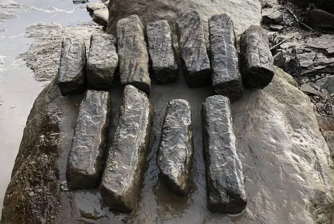
Sharpening stones may be made from sandstone, quartz-rich rock, fine-grained sedimentary stone, or other materials with suitable abrasive properties.

Their effectiveness depends on grain size, hardness, surface texture, and the presence of water or other lubricating substances.

Some stones are coarse and designed to remove damaged material quickly. Others have finer surfaces that produce a smoother cutting edge.

Ancient users may have selected different stones according to the type of tool being maintained.

Household Iron Tools and Their Maintenance

Iron tools were used in many domestic activities.

Knives were essential for food preparation and general cutting. Small blades could be used for craft work, while axes and agricultural implements supported heavier tasks.

As tools became worn, households could repair or sharpen them rather than replacing them entirely.

This was economically practical because iron production required fuel, skilled labor, and access to raw materials or trading networks.

Maintaining a tool extended its useful life and reduced the need to acquire new equipment.

Sharpening could therefore form part of regular household maintenance rather than being restricted to specialized workshops.

Identifying Sharpening Stones Archaeologically

A stone found in a household deposit is not automatically a sharpening tool.

Archaeologists examine its shape, surface texture, wear patterns, and relationship to other artifacts.

Repeated abrasion may produce smooth areas, grooves, or localized depressions. Some stones develop elongated wear surfaces where blades were repeatedly drawn across them.

The presence of metal particles may provide additional evidence, although such residues can be difficult to identify and may result from later contamination.

A stone with a suitable abrasive texture and characteristic wear is more convincing when discovered alongside iron tools and other domestic equipment.

Types of Wear and Sharpening Techniques

Different sharpening techniques produce different patterns of wear.

A blade may be drawn repeatedly across a flat stone, producing a relatively smooth and elongated surface.

A narrow stone may be used for sharpening smaller blades or tools with restricted edges.

Grooved stones may be associated with the maintenance of pointed objects or narrow metal components, although their exact functions vary.

Some stones may have been used with water to reduce friction and remove metal particles. Others may have been used dry.

The interpretation of a particular stone requires comparison with experimentally produced wear patterns and known historical examples.

Household Sharpening and Craft Production

The discovery of sharpening stones within a household may indicate that tools were maintained locally.

However, not every sharpening stone belonged to a domestic setting. Similar objects could have been used by blacksmiths, carpenters, farmers, leatherworkers, and other craftspeople.

Archaeologists examine the wider assemblage to distinguish household maintenance from specialized production.

A settlement containing several sharpening stones, ironworking debris, slag, and unfinished metal objects may have supported metalworking activities.

By contrast, an isolated sharpening stone associated with domestic pottery and food remains may reflect ordinary household tool maintenance.

Material Sourcing and Trade

The geological origin of a sharpening stone can provide information about how it was acquired.

Some stones may have been collected locally from riverbeds, hillsides, or exposed rock formations.

Others may have been transported from specialized quarrying areas.

Petrographic analysis can identify mineral composition and compare the stone with known geological sources.

If a sharpening stone originated far from the settlement where it was found, it may indicate exchange or movement through regional trade networks.

However, geological sourcing must account for the possibility that similar stone types occur in several locations.

Dating Sharpening Stones

Sharpening stones are difficult to date directly because stone itself may remain unchanged for long periods.

Their chronology is usually established through archaeological context.

Pottery, coins, metal objects, and other associated materials can help date the deposits in which sharpening stones are found.

Stratigraphic relationships may reveal whether a stone was deposited during an early occupation phase or introduced through later activity.

Wear patterns can indicate repeated use, but they do not independently establish a precise date.

Some sharpening stones may also have been inherited or reused over generations, making their period of manufacture different from the date of their final deposition.

Experimental Archaeology

Experimental research can help determine how sharpening stones were used.

Researchers can produce replicas of ancient iron tools and sharpen them using stones with comparable geological characteristics.

The resulting wear patterns can be compared with archaeological examples.

Experiments may also investigate how water, pressure, blade angle, and sharpening duration affect the stone surface and metal edge.

This work helps distinguish sharpening from other possible activities, such as grinding pigments, polishing objects, or shaping small stone tools.

Social and Economic Significance

Sharpening stones provide evidence of the practical value attached to tools.

A household that regularly maintained its iron equipment could reduce replacement costs and preserve important resources.

The presence of specialized stones may also indicate knowledge of tool maintenance and the availability of materials suitable for sharpening.

In some settings, sharpening may have been performed by particular household members or skilled craftspeople. However, assigning specific social roles requires additional evidence.

Comparing sharpening stones across different households may help researchers investigate differences in occupation, wealth, and access to technology.

Conclusion

Household iron sharpening stones provide a small but valuable window into the maintenance practices of ancient communities. Their wear patterns, geological composition, and archaeological context can reveal how people preserved the usefulness of knives, agricultural tools, and other iron equipment. Because sharpening stones could also serve other grinding and polishing functions, identifying their purpose requires careful examination and comparison with experimental evidence. Through these studies, archaeologists can better understand the everyday technologies that supported domestic life and the long-term use of iron tools.

Microfossils from Hearths: Reconstructing Paleodiets on the Margins

November 8, 2026

Introduction

Hearths are among the most informative features found at archaeological sites. They provide evidence of cooking, heating, food preparation, and other activities that took place around domestic or temporary living spaces. Their contents may include charcoal, ash, burned bones, seeds, shells, and fragments of other materials.

Beyond these visible remains, hearth deposits can preserve microscopic biological evidence. Microfossils, including pollen, phytoliths, starch grains, and other microscopic remains, may provide information about plants and food materials that were processed or consumed by ancient communities.

The study of hearth microfossils is particularly valuable when investigating populations living in environmental or economic margins, where food sources may have been diverse and archaeological remains limited. These tiny traces can help reconstruct diets that are not fully represented by large bones, seeds, or pottery.

Understanding Microfossils

Microfossils are microscopic remains of biological organisms or structures. In archaeological research, the term includes several kinds of evidence that can survive in sediments, tools, pottery, and hearth deposits.

Important examples include phytoliths, starch grains, pollen, and microscopic animal remains.

Phytoliths are microscopic silica structures formed within plant tissues. They can survive after the rest of the plant has decomposed or burned.

Starch grains are microscopic carbohydrate particles produced by many plants. Their shapes and surface characteristics may help identify particular plant groups.

Pollen grains can provide information about vegetation and environmental conditions. They may also enter archaeological deposits through food preparation or the movement of plant materials.

Each type of microfossil has different preservation characteristics and interpretive limitations.

Why Hearths Preserve Dietary Evidence

Hearths concentrate materials associated with repeated domestic activity. When plants, animals, and other resources are processed near a fire, small fragments may become incorporated into ash and surrounding sediments.

Some plant materials may become charred during cooking. Others may be deposited accidentally through fuel, food preparation, or cleaning activities.

Heat can destroy many biological structures, but it can also preserve certain remains by carbonizing them or reducing biological decay.

The distribution of microscopic remains within a hearth can provide clues about where different activities occurred.

For example, deposits near a cooking surface may contain different materials from those found in surrounding ash layers.

Plant Microfossils and Ancient Diets

Plant foods were essential components of many ancient diets, but they are often underrepresented in archaeological deposits.

Grains, roots, tubers, fruits, leaves, and seeds do not all preserve equally well. Some decay rapidly, while others survive only under particular environmental conditions.

Starch grains can sometimes be recovered from grinding stones, pottery, and sediment samples. Their presence may indicate that starchy plants were processed at a particular location.

Phytoliths may reveal the presence of grasses and other plant groups, including materials that were used for food, fuel, bedding, or construction.

Researchers must distinguish between plants that were eaten and those introduced for other purposes. A phytolith in a hearth may have come from cooking fuel rather than food.

Animal Remains and Microfaunal Evidence

Hearth deposits may also preserve microscopic animal remains.

These can include fish scales, tiny bones, shell fragments, and other biological particles.

Such remains can help identify food resources that might be overlooked when archaeologists examine only large animal bones.

Small fish and aquatic organisms may have been important sources of nutrition, particularly for communities living near rivers, lakes, wetlands, or coastlines.

Microfaunal evidence can also reveal the processing of small animals, although it must be interpreted carefully because some remains may have entered the deposit through natural processes.

Dietary Reconstruction in Marginal Environments

The term "marginal" can refer to environments where agricultural production is limited or where communities rely on diverse and flexible subsistence strategies.

These settings may include high-altitude regions, dry landscapes, rocky coastlines, forests, and areas with short growing seasons.

People living in such environments often combined multiple food sources. They might cultivate crops, gather wild plants, hunt animals, fish, and collect shellfish.

Microfossil analysis can help identify this diversity.

For example, plant residues may reveal the use of wild resources that are not represented in nearby agricultural deposits. Microscopic fish remains may indicate aquatic food consumption even when larger bones are absent.

Laboratory Techniques

Microfossil research begins with careful sampling. Archaeologists collect sediment from hearth layers and compare it with samples from surrounding areas.

This comparison helps determine whether a particular biological material is genuinely associated with human activity or simply part of the natural environment.

Microscopy is used to examine the size, shape, and surface characteristics of recovered particles.

Starch analysis can identify features that may be compared with modern reference collections. Phytolith analysis relies on differences in silica structures, while pollen analysis examines grain morphology.

Researchers may also use chemical treatments to separate microfossils from sediment, although these procedures must be selected carefully to avoid damaging delicate remains.

Contamination and Interpretive Problems

Microfossils can move through sediment because of water, insects, roots, animals, and human disturbance.

A hearth that appears undisturbed may contain microscopic material introduced long after its original use.

Modern contamination can also occur during excavation, storage, and laboratory processing.

Researchers therefore use control samples and compare several deposits from the same site.

The presence of a microfossil should not automatically be interpreted as evidence of consumption. It may represent fuel, construction material, animal bedding, or environmental vegetation.

The strongest dietary interpretations combine microfossils with visible food remains, tool evidence, residues, and the wider archaeological context.

Combining Microfossils with Other Dietary Evidence

Microfossil analysis becomes more useful when combined with other methods.

Animal bones can reveal which species were butchered and consumed. Carbonized seeds may identify cultivated and gathered plants. Residue analysis of pottery can provide evidence of substances prepared in vessels.

Stable isotope analysis of human and animal remains can contribute information about broad dietary patterns, although it generally does not identify every specific food consumed.

Together, these methods can provide a more complete picture of ancient food systems than any single source of evidence.

Social and Cultural Dimensions of Food

Diet is not only a biological necessity. Food choices are influenced by cultural traditions, economic status, religious practices, and social relationships.

Different households may have used different food resources depending on their access to land, livestock, markets, or wild environments.

Hearth deposits can sometimes reveal these differences. Separate cooking areas or distinct patterns of plant and animal remains may indicate variation in food preparation.

However, interpreting social identity from microscopic remains alone is difficult. Archaeologists must consider household organization, settlement patterns, and other forms of evidence.

Conclusion

Microfossils from hearths offer valuable opportunities to reconstruct ancient diets, especially in environments where conventional food remains are poorly preserved or incomplete. Phytoliths, starch grains, pollen, and microscopic animal remains can reveal the use of plants and small animals that might otherwise remain invisible in the archaeological record. However, their presence does not automatically prove consumption, because fuel, construction materials, environmental processes, and later contamination can introduce similar evidence. By combining microfossil analysis with excavation context, residue studies, animal remains, and other scientific methods, researchers can develop a more detailed understanding of how ancient communities obtained, prepared, and consumed food.

Ancient River Locks: Water Management Before Modern Engineering

November 8, 2026

Introduction

Rivers have always been important to human settlement, providing water for drinking, agriculture, transportation, fishing, and industry. However, rivers are dynamic environments. Their water levels fluctuate, currents change, and seasonal flooding can disrupt movement and damage settlements. Ancient communities therefore developed different methods to control water and make rivers more useful.

Among the most interesting possibilities in the history of water management are early river-control structures that may have performed functions similar to locks. Modern locks allow vessels to move between sections of waterways with different water levels by raising or lowering the water inside a chamber. Ancient societies developed many forms of canals, gates, dams, and navigation structures, although not all of them should be classified as true locks.

Investigating early river locks helps explain how communities adapted waterways for transportation and resource management before modern engineering.

Understanding River Locks

A river lock is a structure that allows boats to pass between sections of water at different elevations. It generally consists of a chamber with gates at both ends.

A vessel enters the chamber, after which one gate is closed. Water is then released into or drained from the chamber until its level matches the destination section of the river or canal. The opposite gate can then be opened, allowing the vessel to continue.

This system makes it possible to navigate waterways that would otherwise contain obstacles created by changes in elevation.

The principle is relatively simple, but constructing a reliable lock requires knowledge of water pressure, flow control, structural stability, and gate operation.

Ancient Water Management Before Locks

Ancient societies developed numerous methods for controlling water long before modern hydraulic engineering.

Dams could store water or redirect river flow. Canals transported water toward agricultural fields and settlements. Sluices allowed operators to regulate the movement of water through channels.

Weirs, which are low structures built across streams or rivers, could raise water levels or divert part of the flow. These structures were sometimes associated with irrigation, milling, or fishing.

Although these technologies were important precursors to more complex navigation systems, they were not necessarily locks. A structure that raises water or controls flow should not automatically be classified as a device for moving boats between different water levels.

The Development of Navigable Waterways

As trade expanded, communities increasingly needed reliable ways to transport heavy materials over long distances. Rivers provided natural transportation corridors, but waterfalls, rapids, shallow sections, and changes in elevation could interrupt navigation.

Engineers and builders responded by modifying waterways. They constructed canals, cleared channels, reinforced banks, and developed structures to regulate water levels.

Some navigation systems relied on simple methods such as dragging boats over obstacles or using separate channels around difficult sections. Others required more complex hydraulic arrangements.

The development of locks was part of a broader history of adapting natural waterways to human transportation needs.

Gates, Sluices, and Early Lock-Like Structures

A gate can control the movement of water through a channel. When combined with a contained basin or chamber, gates may contribute to a system capable of adjusting water levels.

However, identifying an ancient lock requires evidence of a deliberate arrangement that allowed vessels to pass between different water levels.

Researchers examine the dimensions of chambers, the placement of gates, the depth of channels, and the relationship between the structure and the surrounding waterway.

A pair of gates does not automatically indicate a lock. The structure may have been designed for irrigation, drainage, flood control, or water storage.

Archaeological interpretation must therefore consider the intended function rather than relying on architectural resemblance alone.

Materials and Construction Techniques

Ancient hydraulic structures were built using materials available in their surrounding environments.

Stone and masonry were useful for constructing durable walls and foundations. Timber could be used for gates, supports, and movable components. Clay and compacted earth might help seal gaps and reduce water leakage.

The choice of materials depended on the force of the water, the local geology, and the resources available to builders.

Wooden components are especially difficult to preserve in many archaeological settings. They may survive in waterlogged environments, but decay rapidly when exposed to oxygen and changing moisture conditions.

Stone foundations and channel walls may remain visible even when the movable parts of a hydraulic structure have disappeared.

Archaeological Identification of Ancient Locks

Archaeologists investigate possible locks through excavation, architectural recording, and hydraulic analysis.

They examine whether a structure contains a chamber large enough to accommodate a vessel, whether gates could have been installed at both ends, and whether the surrounding channels show evidence of navigation.

Wear patterns may provide additional clues. Repeated contact from boats, ropes, or movable gates could leave distinctive marks on stone or timber.

Sediment deposits can reveal changes in water levels and patterns of flow. Researchers may also examine nearby settlements, ports, warehouses, and transportation routes to determine whether the structure served commercial navigation.

The most convincing interpretation requires several forms of evidence to support one another.

Dating Hydraulic Structures

Dating river-control structures can be difficult because they were frequently repaired and modified.

Radiocarbon dating may be possible when wooden gates, supports, or other organic materials survive. Dendrochronology may provide more precise dates if suitable timber contains recognizable annual growth rings.

Ceramics, coins, and other artifacts recovered from construction or maintenance deposits can offer additional chronological information.

Stratigraphic relationships help establish whether a channel was built before or after nearby structures.

Researchers must distinguish the original construction date from later repairs. A river structure may have remained in use for centuries, with several generations of modifications.

Economic and Social Importance

River locks and related hydraulic systems could have supported regional trade by making difficult waterways more navigable.

Improved navigation could reduce the need for overland transport and make it easier to move heavy agricultural products, building materials, and commercial goods.

Such structures also required maintenance. Gates had to be repaired, channels cleared, and water levels monitored.

This work may have depended on local communities, specialized builders, or political authorities. The organization of hydraulic infrastructure can therefore provide information about administration and cooperation.

Control over a navigable waterway could also have economic and political importance, particularly when it influenced access to markets or strategic settlements.

Environmental Risks and Engineering Limitations

Ancient river engineering faced many of the same environmental challenges encountered by modern projects.

Floods could damage walls and gates. Sediment could accumulate in chambers and channels. Seasonal drought could reduce water availability, making navigation difficult.

Builders needed to understand the behavior of the river and adapt structures to changing conditions.

A lock that worked during one season might become unusable during another. Maintenance and local knowledge were therefore essential.

Conclusion

Ancient river locks represent an important possibility in the development of water-management and transportation technology. Although many early societies constructed dams, sluices, canals, and other hydraulic structures, not every water-control installation functioned as a true navigation lock. Establishing the presence of an ancient lock requires evidence of a chamber, controllable gates, and a system designed to move vessels between different water levels. Through archaeological excavation, hydraulic reconstruction, dating, and landscape analysis, researchers can investigate how early communities transformed rivers into more reliable transportation networks.

Petroglyphs as Territorial Markers in Andean Highlands

November 8, 2026

Introduction

The Andean highlands contain a remarkable variety of archaeological landscapes, including ancient settlements, ceremonial centers, agricultural terraces, roads, and rock art. Among the most intriguing forms of evidence are petroglyphs: images and symbols carved or pecked into exposed rock surfaces. These markings may represent animals, human figures, geometric patterns, hunting scenes, or abstract designs.

Beyond their artistic and symbolic significance, petroglyphs may also have played a role in defining relationships between communities and their surrounding territories. Some researchers investigate whether particular rock-art locations marked routes, resource areas, boundaries, or places of collective identity. Understanding these possibilities requires examining the relationship between the images, their landscape, and the archaeological remains around them.

Understanding Andean Petroglyphs

Petroglyphs are images created by removing or modifying the surface of a rock. Ancient artists used techniques such as pecking, scratching, incising, and abrasion to produce recognizable forms.

In the Andes, rock art appears in a wide range of environments, from high-altitude valleys and mountain slopes to river corridors and desert margins. Its imagery varies by region and period.

Common subjects include camelids, such as llamas and alpacas, as well as wild animals, human figures, footprints, weapons, and geometric patterns. Some compositions may represent activities such as hunting, herding, travel, or ceremonial gatherings.

The meaning of individual images is not always clear. A figure that appears to represent a boundary marker may instead have religious, commemorative, or decorative significance.

Territorial Organization in the Andean Highlands

Andean communities developed complex systems for organizing land and resources. Access to agricultural terraces, grazing areas, water sources, mineral deposits, and transportation routes could be essential to their survival.

Territorial organization did not always depend on permanent fences or clearly defined property lines. Communities could recognize customary rights through shared knowledge, seasonal practices, kinship relationships, and agreements with neighboring groups.

In this context, prominent rock formations could become meaningful reference points. A carved rock might identify a location associated with a community, a route, a resource area, or a ceremonial landscape.

However, the presence of petroglyphs near a resource area does not automatically establish that they marked ownership. Their function must be evaluated within the wider archaeological and cultural context.

Petroglyphs and Natural Boundaries

The physical placement of rock art can provide important clues about its possible purpose.

Some carvings occur near mountain passes, river crossings, valley entrances, and natural corridors. These locations were significant because they connected different ecological zones and facilitated the movement of people and animals.

A marked rock at a narrow passage may have served as a recognizable landmark. It could have helped travellers identify a route or understand that they were entering an area associated with a particular community.

Other carvings appear on isolated boulders or prominent rock faces visible from considerable distances. Their visibility may have contributed to their social or symbolic importance.

Researchers must distinguish between deliberate territorial signaling and the practical use of recognizable landmarks.

Camelid Imagery and Pastoral Territories

Camelids were central to many Andean economies. Llamas and alpacas provided transport, wool, meat, and other resources, while wild vicuñas and guanacos were also important in hunting and resource management.

Petroglyphs depicting camelids may therefore be connected with pastoral life.

A group of animal figures near a traditional grazing route could reflect the economic importance of herding in that landscape. It might also represent ritual practices associated with animal fertility, protection, or community identity.

In some settings, repeated imagery may help researchers investigate relationships between rock-art locations and seasonal livestock movement.

Nevertheless, animal carvings cannot be treated as direct maps of ancient pasture boundaries without supporting evidence.

Rock Art and Community Identity

Territorial identity can involve more than the control of land. It may include ancestry, shared history, religious beliefs, and relationships with particular mountains, springs, or other natural features.

Petroglyphs could have helped preserve these connections by marking places where people gathered, conducted ceremonies, or remembered significant events.

Repeated visits to a marked location may have strengthened its importance across generations. The images could become part of a shared visual tradition recognized by members of a community.

Different communities might also have used distinctive artistic styles. Comparing these styles can help researchers investigate cultural relationships, although artistic similarities do not necessarily prove common political authority.

Archaeological Methods for Studying Territorial Functions

Researchers begin by documenting the location and physical characteristics of petroglyphs. Detailed photography, three-dimensional scanning, and digital mapping can preserve information about individual carvings.

Geographic information systems can help examine the relationship between rock-art sites and nearby resources, settlements, routes, and natural boundaries.

Archaeologists may also compare the imagery with nearby pottery, architecture, burial sites, and other material remains.

Dating petroglyphs is particularly challenging because the act of carving does not always leave organic material suitable for radiocarbon analysis. Researchers may instead use associated archaeological deposits, superimposed images, weathering studies, or other chronological evidence.

Even these methods require caution because a rock surface may have been used repeatedly over centuries.

Petroglyphs and Long-Distance Routes

The Andean highlands contained extensive networks of paths connecting settlements and ecological zones.

People moved between highland pastures, agricultural valleys, mineral sources, and regional exchange centers. Marked rocks could have helped travellers recognize important locations along these routes.

Some petroglyphs may have communicated information about water sources, dangerous passages, or places of social significance.

Others may have been associated with ritual activities performed before or after a journey.

Comparing rock-art locations with reconstructed transportation networks can help researchers investigate whether certain carvings were associated with movement through the landscape.

Challenges of Interpretation and Preservation

Petroglyphs are vulnerable to natural weathering, erosion, mineral deposits, and biological growth. Modern activities such as construction, mining, tourism, and deliberate vandalism can cause irreversible damage.

Another difficulty is the temptation to interpret unfamiliar symbols using modern assumptions. A geometric pattern may appear to represent a territorial boundary, but its original meaning could be entirely different.

Ethnographic research and collaboration with Indigenous communities can provide valuable perspectives. Local traditions may preserve knowledge about the cultural significance of particular rocks and landscapes.

However, present-day interpretations should not automatically be projected backward onto every ancient carving.

Conclusion

Petroglyphs in the Andean highlands may have contributed to the ways communities recognized, remembered, and organized their territories. Their locations near mountain passes, resource areas, and transportation corridors make them particularly valuable for investigating relationships between rock art and landscape use. Nevertheless, territorial marking is only one possible interpretation among several. Through detailed documentation, geographic analysis, archaeological comparison, and collaboration with local communities, researchers can better understand how carved rocks participated in the social and symbolic organization of Andean landscapes.

The Use of Seagrass Mattresses in Ancient Ship Cabins

November 8, 2026

Introduction

Life aboard ancient ships required practical solutions to problems involving comfort, storage, hygiene, and limited space. Sailors and passengers spent long periods in confined environments where sleeping arrangements had to accommodate movement, moisture, and changing weather conditions.

Among the possible materials used for bedding and cabin furnishings were plant fibers, animal materials, woven textiles, and dried vegetation. Seagrass is an interesting candidate because coastal communities had access to marine plant resources that could be dried and used for various purposes.

The study of seagrass mattresses in ancient ship cabins raises questions about maritime domestic life and the use of coastal materials. However, direct evidence can be difficult to identify because plant-based bedding rarely survives in ordinary archaeological conditions.

Understanding Seagrass

Seagrasses are flowering plants that grow in shallow marine environments. Unlike seaweeds, which are algae, seagrasses possess roots, leaves, and underground stems.

They form underwater meadows in coastal areas where light reaches the seabed. These ecosystems provide habitats for marine animals, stabilize sediments, and contribute to coastal environmental health.

After natural die-off or collection, dried seagrass can become fibrous and lightweight. Depending on the species and preparation, it may be suitable for packing, weaving, cushioning, or other practical uses.

However, not every marine plant traditionally called sea grass is a true seagrass. Historical terminology and archaeological identification must account for differences between seagrasses, algae, reeds, and other coastal vegetation.

Why Seagrass Could Be Used for Bedding

Dried plant material can provide cushioning when placed inside a fabric or woven container. Seagrass fibers may have been used as stuffing for mattresses, pads, or sleeping surfaces.

Such materials could have been relatively accessible in coastal communities and did not require the same processing as some animal-based bedding materials.

A mattress filled with dried vegetation could also be adjusted or replaced when necessary. In a ship environment, this would have been practical if the material was locally available and easy to transport.

However, seagrass has limitations. It can absorb moisture, become compacted, and develop unpleasant odors if stored in damp conditions. Its suitability would therefore depend on drying, preparation, and maintenance.

Sleeping Arrangements Aboard Ancient Ships

Ship interiors varied according to vessel size, purpose, and cultural tradition. Large vessels might include designated spaces for officers, passengers, or valuable cargo, while smaller boats offered little separation between working and sleeping areas.

Crew members could sleep on simple platforms, mats, blankets, or other portable bedding. More elaborate vessels may have included enclosed cabins with furnishings.

A mattress would need to be compact enough to fit within the available space. It might also be removed or secured during rough weather.

The archaeological study of ship cabins can help reconstruct these arrangements, although the survival of interior furnishings is often limited.

Archaeological Evidence for Plant-Based Bedding

Direct evidence of seagrass mattresses would be difficult to recognize because organic fibers decay in many burial environments.

In waterlogged shipwrecks, plant material may survive under favorable conditions. It may also be preserved through mineralization, impressions in surrounding materials, or residues trapped inside containers.

Researchers can examine fiber structure under a microscope to distinguish plant materials from animal fibers. Botanical identification may be possible when sufficiently preserved tissues are available.

The location of the material is also important. Fibers found in a compacted layer near a sleeping platform may be consistent with bedding, while similar material in a cargo compartment could have served as packing.

Distinguishing Seagrass from Other Bedding Materials

Ancient ships could have used many different types of plant material. Reeds, grasses, straw, leaves, moss, and other vegetation may have been used as stuffing or padding.

Seagrass identification requires botanical analysis rather than relying on a general description of a fibrous material.

Researchers may compare preserved fragments with reference specimens, examining leaf structure, cell patterns, and other diagnostic features.

Chemical analysis can sometimes help identify the presence of marine-derived organic materials, but environmental contamination can complicate interpretation.

A claim that a mattress was specifically filled with seagrass therefore requires stronger evidence than the discovery of unidentified plant fibers.

Moisture, Ventilation, and Maintenance

Ship cabins presented difficult environmental conditions. Moisture could enter through leaks, condensation, wet clothing, and waves.

Bedding materials needed to be dried and maintained to reduce deterioration and unpleasant odors. Plant-filled mattresses could be removed from the cabin and exposed to sunlight or ventilation when conditions allowed.

Storage arrangements may also have influenced the preservation of bedding. A mattress kept above the deck or inside a dry compartment would have different exposure conditions from one placed directly against a damp wooden surface.

These practical considerations can help researchers evaluate whether a particular plant material would have been suitable for use aboard a vessel.

Maritime Trade and the Availability of Seagrass

Seagrass meadows occur in many coastal regions, but their distribution varies according to water depth, temperature, salinity, and seabed conditions.

Communities living near these environments could have collected plant material for domestic and maritime uses.

Seagrass products might also have moved through local exchange networks, particularly if dried fibers were used in packing, mats, or other manufactured items.

However, the presence of seagrass in a shipwreck does not necessarily mean that it was collected locally. It could have been transported as cargo, used as packing material, or introduced through later environmental processes.

Experimental Reconstruction

Experimental archaeology can help evaluate the potential use of seagrass in bedding.

Researchers can collect appropriate plant materials, dry them under controlled conditions, and use them to produce small mattresses or cushions.

These replicas can be tested for weight, flexibility, comfort, moisture retention, durability, and ease of maintenance.

Comparisons with reeds, straw, and other plant fibers may reveal whether seagrass offered particular advantages.

Such experiments can demonstrate practical suitability, but historical use still requires archaeological evidence from securely dated maritime contexts.

Conservation of Organic Shipwreck Remains

Shipwrecks can preserve organic materials under waterlogged conditions, but recovery creates new risks.

Once exposed to air, waterlogged fibers may shrink, weaken, or become contaminated by microorganisms. Conservation specialists must therefore stabilize fragile materials before they dry.

Recording the exact location of plant remains is equally important. A bundle of fibers found beside a cabin structure may have a different interpretation from similar material found in a cargo area.

Three-dimensional recording, sediment sampling, and careful conservation can preserve evidence that would otherwise disappear during excavation.

Conclusion

The possible use of seagrass mattresses in ancient ship cabins offers an interesting perspective on maritime living conditions and the practical use of coastal resources. Dried seagrass could have served as a lightweight stuffing material for bedding or cushions, although other plant fibers may have been equally suitable. Establishing its use requires botanical identification, secure archaeological context, and careful distinction from packing materials and other forms of plant debris. Through shipwreck archaeology, experimental reconstruction, and conservation science, researchers can investigate how ancient sailors created more comfortable living spaces aboard vessels.

Early Distillation Traces in Domestic Vessels Outside the Middle East

November 8, 2026

Introduction

Distillation is a process in which a liquid is heated to produce vapor, which is then cooled and collected as a separate liquid. It has played an important role in the history of chemistry, medicine, perfumery, and the production of concentrated substances.

The history of distillation is often associated with developments in the ancient and medieval Middle East, where written technical traditions and specialized apparatus are well documented. However, the broader archaeological question is whether related practices existed in domestic contexts elsewhere and whether ordinary household vessels sometimes served as components of early distillation systems.

Investigating possible early distillation outside the Middle East requires careful attention to chronology, equipment design, and chemical evidence. A vessel that appears capable of producing condensed liquid does not automatically prove that distillation occurred.

Understanding the Distillation Process

Distillation separates substances according to differences in their volatility. A liquid mixture is heated, causing one or more components to enter the vapor phase. The vapor then travels into a cooler area, where it condenses and can be collected.

A simple distillation arrangement generally requires a heating vessel, a route for vapor to escape, a cooling surface or chamber, and a receiving container.

The equipment does not always need to resemble a modern laboratory apparatus. Early systems could have been assembled from ceramic vessels, metal components, tubes, lids, and other materials.

However, the effectiveness of a device depends on how well its components are connected and whether vapor can be collected without escaping.

Domestic Vessels and Experimental Uses

Household pottery was often versatile. Cooking pots, jars, bowls, lids, and narrow-necked vessels could be adapted for different activities.

A vessel with a fitted lid might help retain steam, while a smaller container placed above or alongside it could potentially collect condensed liquid. In some experimental arrangements, a cooled surface could encourage vapor to condense.

Such arrangements may resemble early distillation equipment, but they could also have been used for steaming, cooking, condensation collection, or other domestic processes.

Archaeologists therefore examine vessel shapes, joining arrangements, heat exposure, residues, and wear patterns before proposing a distillation function.

Distillation and Other Heating Technologies

Distillation should be distinguished from other processes that involve heating liquids.

Boiling produces vapor but does not necessarily involve collecting the vapor as a separate liquid. Steaming uses water vapor to heat or cook materials, while evaporation allows liquid to escape into the surrounding air.

Condensation occurs when vapor cools and returns to a liquid state. This can happen naturally on a lid or surface without the deliberate separation of a mixture.

Evidence of heating and condensation may therefore demonstrate a particular technological possibility without proving that the vessel was used for distillation.

Possible Uses in Domestic Contexts

If early domestic distillation occurred outside the Middle East, possible applications could have included the preparation of aromatic liquids, medicinal substances, and concentrated plant extracts.

Communities already possessed knowledge of heating, fermentation, herbal preparations, and the use of aromatic plants. Such knowledge could have provided a foundation for experimenting with vapor collection.

However, the existence of herbal medicine or perfume production does not demonstrate the use of distillation. Many aromatic preparations could be made through crushing, soaking, pressing, or heating plant materials without collecting condensed vapor.

Researchers must therefore avoid treating every residue associated with herbs or oils as evidence of distillation.

Archaeological Evidence and Vessel Identification

The identification of possible distillation equipment begins with the examination of vessel design.

Researchers may look for unusual openings, fitted lids, connecting tubes, narrow channels, or arrangements that could direct vapor from one container to another.

Heat alteration can help establish whether a vessel was exposed to sustained heating. Soot deposits, thermal cracking, and mineral changes may provide information about its use.

Residue analysis can identify substances that were processed in a vessel, although chemical traces alone rarely establish the exact process.

The discovery of several vessels with complementary shapes and associated heating installations may provide stronger evidence than a single unusual pot.

Scientific Methods for Investigating Distillation

Experimental archaeology is particularly valuable for testing proposed distillation systems. Researchers can reproduce vessel arrangements using materials and techniques available in the period being investigated.

By heating different liquids and monitoring vapor movement, researchers can determine whether the arrangement is capable of collecting a condensed product.

Chemical analysis may identify residues consistent with particular plant materials, oils, or other processed substances. However, these results must be interpreted alongside the apparatus itself.

Microscopy can reveal surface alterations, while chemical analysis of deposits may identify repeated exposure to specific liquids.

The combination of experimental performance and archaeological context is essential. A modern reconstruction may work successfully without proving that ancient people actually used the same arrangement.

Regional Variation Outside the Middle East

Technological knowledge did not develop in isolation. Trade, migration, craft exchange, and political contact allowed ideas and equipment to move between regions.

Possible distillation-related practices outside the Middle East must therefore be examined within their regional historical contexts.

Some communities may have adopted techniques through direct contact, while others may have developed similar arrangements independently. The appearance of comparable equipment does not automatically establish a single point of origin.

Chronology is especially important. Researchers need securely dated evidence to determine whether a proposed device predates, overlaps with, or follows known distillation traditions elsewhere.

The Difference Between Distillation and Alcohol Production

Distillation is often associated with alcoholic beverages, but the two should not be treated as identical.

Fermentation produces alcohol through the activity of microorganisms. Distillation can then concentrate alcohol by separating it from other components of a fermented liquid.

However, distillation can also be used for substances unrelated to alcohol, including aromatic waters and certain chemical preparations.

Finding evidence of fermentation therefore does not establish distillation, and a possible distillation apparatus does not automatically indicate alcohol production.

Limitations and Interpretive Caution

The archaeological evidence for early distillation can be ambiguous because equipment may have been made from perishable materials or assembled temporarily.

A system using metal tubes, wooden supports, and ordinary pottery may leave only fragments that are difficult to interpret.

Furthermore, many domestic vessels had multiple functions. Their shapes may reflect cooking or storage rather than specialized chemical processing.

Claims about early distillation should therefore depend on secure dating, convincing equipment arrangements, and evidence that distinguishes vapor collection from other heating processes.

Conclusion

The investigation of early distillation traces in domestic vessels outside the Middle East expands the study of ancient chemical technology beyond specialized laboratories and written traditions. Household pottery may have been adapted for experiments involving vaporization and condensation, but identifying genuine distillation requires more than evidence of heating or steam. Through archaeological context, vessel analysis, residue testing, experimental reconstruction, and careful chronological comparison, researchers can evaluate when and where distillation practices emerged and how technical knowledge circulated between different societies.

Small Defense Towers: Signal Networks in Medieval Coasts

November 8, 2026

Introduction

Medieval coastal regions were exposed to a variety of threats, including piracy, raiding, military attacks, and unauthorized movement through important maritime routes. Communities and political authorities developed different strategies to monitor coastlines and communicate warnings across long distances.

Among these strategies were small defensive towers positioned on headlands, islands, cliffs, and other elevated locations. Although some towers were primarily intended for observation or protection, others may have formed part of broader signal networks that allowed information to travel between settlements.

The archaeological study of these structures can reveal how medieval societies organized coastal surveillance, responded to threats, and used architecture to communicate across maritime landscapes.

The Purpose of Coastal Defense Towers

A coastal defense tower is a relatively small fortified structure designed to provide observation, protection, or both. Its elevated position could allow occupants to monitor approaching vessels and observe activity along the shoreline.

Some towers may have been occupied permanently, while others were used only during periods of heightened danger. Their size and construction varied according to local resources, political authority, and the level of threat.

A tower could also serve multiple functions. It might provide shelter for guards, protect a small group of people, store equipment, and act as a visible symbol of authority.

The defensive value of a tower depended on its location. A structure overlooking a narrow maritime passage could be more strategically useful than a larger tower placed along an open and easily bypassed shoreline.

The Development of Coastal Signal Networks

Signal networks allowed communities to communicate information without requiring messengers to travel between every settlement.

A warning could be transmitted from one observation point to another using visible signals. Depending on local traditions and environmental conditions, these signals might include smoke, flames, flags, banners, or other recognizable arrangements.

A series of towers placed within visual range could allow information to travel along a coastline. This arrangement would be particularly useful when approaching vessels needed to be identified quickly.

However, not every coastal tower formed part of an organized network. Some may have operated independently or communicated only with nearby settlements.

Evidence of a formal signal system requires more than the presence of several towers. Researchers must consider their visibility, spacing, architectural similarities, and historical context.

Choosing Tower Locations

The location of a defensive tower was essential to its effectiveness.

Elevated headlands offered broad views of the sea, while islands could provide observation points along important shipping routes. Towers near harbours and river mouths could monitor incoming vessels and protect access to inland waterways.

Visibility between structures was another important consideration. A signal network required locations from which warnings could be seen by neighboring stations under suitable conditions.

Researchers can use geographic information systems to reconstruct possible lines of sight. Digital elevation models help identify whether hills, cliffs, and other features would obstruct communication.

Modern vegetation and construction may differ from medieval conditions, so visibility models must account for historical changes in the landscape.

Architectural Features of Small Towers

Small defense towers were often constructed using local stone, brick, or combinations of building materials.

Their walls could be thick relative to their size, providing protection against attack and environmental exposure. Some structures included narrow openings, elevated entrances, or limited access points to make entry more difficult.

Upper levels may have provided observation platforms, while lower rooms could have been used for storage or shelter.

Not all towers contained elaborate defensive features. Some may have been simple watchtowers designed primarily for visibility rather than resistance to prolonged attack.

Archaeologists examine wall construction, doorways, staircases, windows, and associated remains to determine how a tower functioned.

Signaling Methods and Environmental Conditions

Smoke and fire were among the possible methods of long-distance signaling. During daylight, smoke could provide a visible warning, while flames might be more effective at night.

Other methods could include flags, banners, reflective materials, or combinations of visual and acoustic signals.

The effectiveness of these systems depended on weather, visibility, distance, and the time available to respond.

Fog, rain, strong winds, and coastal storms could interrupt communication. A network might therefore have required alternative methods or additional observation points.

The archaeological record rarely preserves the actual signals. Researchers often rely on historical accounts, architectural features, and the geographic relationship between towers to investigate how communication may have worked.

Archaeological Evidence for Signal Activity

Evidence of signal use may include hearths, fire platforms, repeated burning deposits, or structures designed to support visible flames.

However, a hearth within a tower could also have been used for cooking and heating. Burnt deposits must therefore be interpreted in relation to their location, construction, and archaeological context.

Storage areas may have contained fuel, signaling equipment, or supplies for guards. Yet such materials are often difficult to identify directly.

Written records, maps, and administrative documents can provide additional information about the operation of coastal watch systems. These sources may describe responsibilities, staffing arrangements, or warning procedures.

The strongest interpretations combine historical documentation with physical evidence.

Political Organization and Coastal Surveillance

Coastal signal networks required coordination. If a warning was expected to travel between towers, guards needed to understand which signals to use and how to respond.

The organization of these systems could reflect the political structure of a medieval territory. Central authorities might appoint guards, maintain towers, and establish rules for responding to maritime threats.

In other cases, local communities may have organized surveillance through shared responsibilities.

The distribution of towers can therefore reveal relationships between central authority and local defense. A coordinated system may indicate administrative planning, while isolated structures may reflect localized responses to particular threats.

Dating and Reconstructing Tower Networks

Dating coastal towers requires examination of construction materials, associated artifacts, and historical records.

Mortar analysis, architectural comparison, pottery, coins, and inscriptions can help establish construction or occupation periods.

Some towers may have been built during one period and modified later. Changes in wall thickness, entrances, or upper structures may indicate adaptation to new defensive requirements.

Geographic analysis can identify potential connections between towers and reconstruct possible communication routes. However, a visually connected arrangement does not prove that a signal network was actually used.

Preservation Challenges

Coastal towers are exposed to salt, wind, rain, and erosion. These environmental conditions can damage masonry and gradually weaken foundations.

Modern construction, coastal development, and changes in land use may also threaten surviving structures.

Conservation requires documentation of wall conditions, construction techniques, and the surrounding landscape. Archaeologists and conservation specialists may use photogrammetry and three-dimensional recording to preserve detailed information about vulnerable buildings.

Conclusion

Small defense towers played an important role in medieval coastal surveillance and may, in some regions, have formed parts of organized signal networks. Their elevated positions allowed guards to observe maritime activity and potentially transmit warnings through smoke, fire, or other visual signals. Nevertheless, the presence of several towers does not automatically establish a coordinated communication system. Through architectural study, geographic visibility analysis, historical research, and archaeological excavation, researchers can investigate how coastal communities monitored threats and organized communication across medieval maritime landscapes.

Subterranean Storehouses in Karst Regions: Preservation and Access

November 8, 2026

Introduction

Karst landscapes are formed through the gradual dissolution of soluble rocks, particularly limestone and dolomite. This geological process creates caves, underground chambers, sinkholes, fissures, and complex drainage systems. For communities living in these environments, natural underground spaces could provide opportunities for storage, shelter, and resource management.

Subterranean storehouses in karst regions are especially interesting because they demonstrate how people adapted natural geological features for practical purposes. Underground spaces may offer relatively stable temperatures and protection from direct sunlight, while their entrances and internal layouts can be modified to control access.

The archaeological study of these storehouses can reveal how communities preserved food and other valuable materials, organized storage, and used the natural features of their landscapes.

Understanding Karst Landscapes

Karst terrain develops when slightly acidic water dissolves soluble bedrock over long periods. Rainwater absorbs carbon dioxide from the atmosphere and soil, forming a weak acid that gradually enlarges cracks and openings in the rock.

Over time, these processes can create caves, underground passages, sinkholes, and chambers. Some karst systems contain underground streams and reservoirs, while others have relatively dry chambers.

The distribution of these features depends on geological structure, climate, groundwater movement, and the history of erosion.

For ancient communities, karst environments offered both opportunities and risks. Natural cavities could provide sheltered spaces, but unstable ceilings, flooding, poor ventilation, and difficult access could make some locations unsuitable for regular storage.

Why Use Subterranean Storehouses?

Underground storage could provide several advantages over exposed surface structures. Temperatures below ground often fluctuate less dramatically than temperatures at the surface. This may help protect certain stored materials from extreme heat and rapid temperature changes.

Darkness could also reduce exposure to sunlight, while natural rock walls might offer protection from wind and some forms of disturbance.

Communities may have used underground spaces to store grain, pottery, tools, food products, and other valuable objects. The exact materials stored would depend on humidity, temperature, ventilation, and the risk of water intrusion.

Not every cave or underground chamber would have been suitable for food storage. Some environments may have been too damp, too cold, or vulnerable to flooding.

Modifying Natural Chambers

A natural cave could be used without major construction, but some communities may have modified underground spaces to improve their usefulness.

Possible modifications include leveling floors, clearing loose rock, constructing low walls, installing doors or barriers, and creating platforms for storage containers.

Entrances may have been narrowed or protected to regulate access. In some cases, steps or simple pathways could have made it easier to reach deeper chambers.

Archaeologists look for tool marks, constructed surfaces, artificial partitions, and repeated architectural modifications. These features can help distinguish deliberate storage facilities from natural caves that were used only occasionally.

Storage Materials and Preservation Conditions

The preservation of stored goods depends on the underground environment. Temperature, humidity, airflow, and water movement all influence how materials survive.

Dry chambers may be suitable for storing certain grains and other materials vulnerable to moisture. More humid environments could support the storage of materials that require protection from drying, although excessive humidity encourages mold and decay.

Ceramic vessels may have been used to contain food or liquids. Baskets, wooden containers, and textiles could also have been employed, although they are less likely to survive in ordinary cave conditions.

Archaeological deposits may preserve fragments of containers, botanical remains, seeds, charcoal, and other evidence of storage activity.

Controlling Access and Protecting Resources

Subterranean storehouses may have required controlled entrances, particularly when they contained valuable food supplies or communal resources.

A narrow entrance could make it easier to monitor movement into a chamber. Doors, stone barriers, or other closures may have been used to prevent unauthorized access or protect stored materials from animals.

The presence of locks or security features would need to be demonstrated through actual archaeological evidence. A blocked entrance alone does not necessarily indicate a secure storehouse because it could also represent natural collapse or deliberate closure for other reasons.

The organization of storage spaces may reveal whether resources were held by individual households, larger families, religious institutions, or community authorities.

Archaeological Identification

Identifying a subterranean storehouse requires evidence that the chamber was deliberately used for storage rather than simply occupied or visited.

Researchers examine the distribution of artifacts, the presence of storage containers, floor modifications, and the relationship between the chamber and nearby settlements.

Repeated deposits of grain, seeds, or other stored materials may provide particularly useful evidence. However, organic remains can be difficult to preserve, especially in humid caves.

The discovery of many ceramic vessels does not automatically prove that a chamber was a storehouse. Vessels may have been used for ritual activities, domestic occupation, or later dumping.

A convincing interpretation depends on the combined evidence of architecture, artifacts, environmental conditions, and repeated use.

Dating Underground Storage Facilities

Radiocarbon dating can be used when suitable organic materials are preserved, such as charcoal, seeds, or wood. These samples may help establish when a chamber was occupied or modified.

Pottery styles and other artifacts can provide additional chronological information. Stratigraphic relationships may also reveal whether storage activity occurred before or after other uses of the cave.

Dating the natural formation of a cave is not the same as dating its use by humans. The geological age of the chamber may be millions of years older than the archaeological activity within it.

Researchers must therefore distinguish the formation of the geological feature from the construction, modification, and occupation of the storehouse.

Environmental Risks and Conservation

Karst environments can be vulnerable to sudden flooding, groundwater changes, and rock collapse. Underground spaces may also contain sensitive deposits that are easily damaged by uncontrolled access.

Modern development, quarrying, tourism, and groundwater extraction can alter the conditions that originally supported preservation.

Archaeological investigation must therefore include geological assessment and appropriate conservation planning. Monitoring humidity, temperature, and water movement can help determine whether fragile materials are at risk.

Caves should not be assumed to provide stable preservation simply because they are underground. Their environmental conditions can vary considerably over short distances.

Social and Economic Significance

Underground storehouses may have contributed to the economic security of communities living in karst regions. They could help preserve seasonal surpluses, protect valuable materials, and provide reserves during periods of limited production.

The scale and organization of a storage facility may offer clues about the community that used it. A small chamber with a few containers may have served a household, while a larger complex with multiple compartments could have supported a broader group.

Shared storage may also have required rules about access, distribution, and maintenance. Such arrangements could reveal aspects of cooperation and social organization.

Conclusion

Subterranean storehouses in karst regions demonstrate how ancient communities could adapt natural geological features to meet practical needs. Underground chambers offered opportunities for storage, protection, and resource management, although their suitability depended on humidity, ventilation, temperature, and flooding risks. Archaeological interpretation requires distinguishing deliberate storage facilities from natural caves and spaces used for other purposes. Through geological survey, artifact analysis, environmental reconstruction, and dating, researchers can better understand how underground landscapes contributed to the economic life of ancient communities.

The Archaeology of Portable Water Filters in Pre-Industrial Societies

November 8, 2026

Introduction

Access to clean drinking water has been a fundamental concern throughout human history. Before the development of modern water-treatment systems, communities relied on natural sources, settling techniques, boiling, and various forms of filtration to improve water quality. Although large-scale aqueducts and public water systems receive considerable attention, smaller technologies used by households and travellers are equally important for understanding everyday water management.

Portable water filters are particularly interesting because they could be carried between settlements, camps, and temporary workplaces. Their archaeological study can reveal how people responded to water quality problems and adapted practical technologies to different environments. However, identifying an ancient object as a water filter requires caution because many perforated containers and porous materials had other purposes.

Understanding Portable Water Filtration

Filtration is the process of separating suspended particles from a liquid by passing it through a material containing small openings or pores. Unlike boiling, which can kill many disease-causing organisms, ordinary filtration primarily removes physical particles and may not make water microbiologically safe.

Pre-industrial communities could use cloth, woven fibers, sand, gravel, porous ceramics, and other materials to strain or clarify water. Some devices may have been designed to remove visible sediment, while others could have served as part of a more complex water-treatment process.

A portable filter would have needed to be relatively light, durable, and convenient to transport. Its design would depend on the materials available and the amount of water that needed to be processed.

Materials Used in Ancient Filtration

Cloth and woven plant fibers are among the simplest possible filtration materials. A piece of fabric could be stretched across a container or used to strain water as it was poured. Such materials would have been easy to replace, although their organic composition makes archaeological preservation unlikely in many environments.

Porous ceramics offer another possibility. Unfired or specially prepared ceramic materials can allow water to pass through while retaining some suspended particles. The effectiveness depends on the clay composition, firing temperature, and size of the pores.

Sand and gravel could also be used in layered filtration arrangements. Water passing through these materials may lose some suspended particles, although the archaeological identification of an ancient portable sand filter would require evidence of a deliberately constructed container and filtration sequence.

Charcoal may have been included in some filtering arrangements because it can adsorb certain substances. However, charcoal alone does not establish that a device was intended for water purification.

Archaeological Identification

Portable water filters are difficult to identify because their forms may resemble ordinary household equipment. A perforated ceramic vessel, for example, could have been used for straining food, draining liquids, preparing cheese, or processing other materials.

Archaeologists examine the object's shape, manufacturing technique, wear patterns, and surrounding deposits. A container with a fine porous structure and evidence of repeated water movement may be consistent with filtration, but its function must be compared with alternative explanations.

Residue analysis can sometimes identify mineral deposits or organic materials that accumulated during use. Microscopic examination may reveal patterns of clogging or repeated cleaning.

The archaeological context is especially important. A suspected filter found near water-storage vessels, wells, or domestic preparation areas may provide a stronger interpretation than an isolated object.

Portable Filters and Travel

Portable filtration may have been useful for people who regularly moved between settlements or worked away from established water supplies. Traders, soldiers, pastoralists, sailors, and travellers all depended on accessible drinking water.

A lightweight straining device could help remove insects, plant fragments, and visible sediment from water collected in rivers, ponds, or temporary sources. It may also have been used to prepare water for cooking or other household activities.

However, there is an important distinction between improving the appearance of water and making it safe to drink. Ancient users may not have understood microorganisms in the modern scientific sense, even if they recognized that some sources were unpleasant or associated with illness.

Water Quality and Environmental Knowledge

Pre-industrial communities developed practical knowledge about water sources through repeated observation. They could recognize differences in taste, smell, color, and sediment content.

Certain springs may have been preferred because their water appeared clearer, while stagnant pools or heavily sedimented streams might have been avoided. Seasonal changes could also influence water quality.

Portable filters would have complemented this knowledge rather than replacing the need to select suitable water sources. Communities could combine filtration with settling, boiling, or storage in clean containers.

The archaeological study of these practices can help reconstruct how people managed water under different environmental conditions.

Scientific Methods for Studying Ancient Filters

Microscopy is useful for examining pore structures, surface wear, and deposits within ceramic or stone materials. Researchers can determine whether a material contains natural openings or whether its surface was deliberately modified.

Chemical analysis may identify mineral residues associated with repeated exposure to water. Organic residue analysis can help detect traces of plant fibers, oils, or other substances, although contamination and preservation conditions must be considered.

Experimental archaeology can test possible uses by reproducing ancient filter designs. Researchers can construct replicas using historically plausible materials and compare their performance when exposed to different water conditions.

Such experiments can demonstrate whether a proposed design is technically workable, but they cannot independently prove that a particular ancient community used it.

Filtration, Storage, and Household Practices

Portable filters may have formed part of a wider system of water management. Water could be collected in a container, allowed to settle, passed through a filtering material, and then stored for later use.

The arrangement of vessels and tools within a household can help researchers identify these activities. A combination of narrow-necked jars, basins, strainers, and storage containers may suggest a sequence of water preparation.

However, many of these objects also served food preparation and other domestic functions. Researchers must therefore consider the full assemblage rather than interpreting one artifact in isolation.

Limitations of the Evidence

Organic filters made from cloth, grass, or other plant fibers are unlikely to survive in many archaeological environments. Their absence from excavated sites does not prove that filtration was unknown.

Portable devices may also have been reused for different purposes. A strainer originally used for food processing could later have been used to remove debris from water.

Furthermore, ancient filtration should not be equated with modern water purification. Many simple filters cannot remove dissolved chemicals or reliably eliminate harmful microorganisms.

Conclusion

The archaeology of portable water filters offers a valuable perspective on everyday technology and the management of freshwater before industrial water-treatment systems. Cloth, porous ceramics, sand, gravel, and other materials could have helped remove visible impurities from water, although their precise functions must be established through archaeological and scientific analysis. By combining artifact study, residue examination, experimental reconstruction, and environmental evidence, researchers can better understand how pre-industrial communities adapted filtration practices to travel, household life, and changing water conditions.

← Newer Posts Older Posts →
Featured
pompeii.webp
November 8, 2026
The Archaeology of Small-Scale Water Filtration Systems in Arid Zones
November 8, 2026
Read more →
November 8, 2026
images - 2026-11-08T152443.003.jpeg
November 8, 2026
The Life Cycle of a Pottery Sherd: Repairing, Recycling, Reusing
November 8, 2026
Read more →
November 8, 2026
cultivation-mussels-oysters-semi-submerged-platform-batea-marine-cultivation-o-grove-galicia-spain-cultivation-mussels-158592606.webp
November 8, 2026
Submerged Platforms for Shellfish Cultivation in Estuaries
November 8, 2026
Read more →
November 8, 2026
images - 2026-11-08T152317.218.jpeg
November 8, 2026
The Archaeology of Hedge‑row Folklore: Material Correlates of Rituals
November 8, 2026
Read more →
November 8, 2026
Fryktoria+a+fire+communication+system+of+ancient+Greece.webp
November 8, 2026
Ancient Beacon Fires: Detecting Signal Networks via Charcoal Trails
November 8, 2026
Read more →
November 8, 2026
images - 2026-11-08T151855.502.jpeg
November 8, 2026
The Use of Ostrich Egg Sacs in Prehistoric Container Technologies
November 8, 2026
Read more →
November 8, 2026
read more

Powered by The archaeologist