• MAIN PAGE
  • LATEST NEWS
    • Lost Cities
    • Archaeology's Greatest Finds
    • Underwater Discoveries
    • Greatest Inventions
    • Studies
    • Blog
  • PHILOSOPHY
  • HISTORY
  • RELIGIONS
    • Africa
    • Anatolia
    • Arabian Peninsula
    • Balkan Region
    • China - East Asia
    • Europe
    • Eurasian Steppe
    • Levant
    • Mesopotamia
    • Oceania - SE Asia
    • Pre-Columbian Civilizations of America
    • Iranian Plateau - Central Asia
    • Indus Valley - South Asia
    • Japan
    • The Archaeologist Editor Group
    • Scientific Studies
    • Aegean Prehistory
    • Historical Period
    • Byzantine Middle Ages
    • Predynastic Period
    • Dynastic Period
    • Greco-Roman Egypt
  • Rome
  • PALEONTOLOGY
  • About us
Menu

The Archaeologist

  • MAIN PAGE
  • LATEST NEWS
  • DISCOVERIES
    • Lost Cities
    • Archaeology's Greatest Finds
    • Underwater Discoveries
    • Greatest Inventions
    • Studies
    • Blog
  • PHILOSOPHY
  • HISTORY
  • RELIGIONS
  • World Civilizations
    • Africa
    • Anatolia
    • Arabian Peninsula
    • Balkan Region
    • China - East Asia
    • Europe
    • Eurasian Steppe
    • Levant
    • Mesopotamia
    • Oceania - SE Asia
    • Pre-Columbian Civilizations of America
    • Iranian Plateau - Central Asia
    • Indus Valley - South Asia
    • Japan
    • The Archaeologist Editor Group
    • Scientific Studies
  • GREECE
    • Aegean Prehistory
    • Historical Period
    • Byzantine Middle Ages
  • Egypt
    • Predynastic Period
    • Dynastic Period
    • Greco-Roman Egypt
  • Rome
  • PALEONTOLOGY
  • About us
No results found

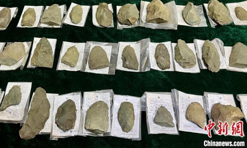
Qugong Village: Tibet's Neolithic Stone Tools

August 18, 2026

Qugong Village, an important prehistoric archaeological site in the Tibetan region, provides valuable evidence for understanding how ancient highland communities produced and used stone tools. The archaeological remains associated with Qugong help illuminate a period of Tibetan prehistory that existed long before written chronicles, monasteries, and the political kingdoms for which the region later became famous.

The study of stone tools may initially appear simple: archaeologists recover pieces of rock shaped by human hands. Yet these artifacts can preserve surprisingly detailed evidence about ancient behavior.

Through stone tools, researchers can investigate:

  • hunting;

  • food preparation;

  • woodworking;

  • hide processing;

  • plant use;

  • and technological knowledge.

At a highland site such as Qugong, these tools also reveal how prehistoric communities adapted to difficult mountain environments.

Understanding Neolithic Stone Technology

The Neolithic period is often associated with agriculture, pottery, and increasingly permanent settlement. However, stone remained one of the most important materials in daily life.

A prehistoric community could produce many specialized tools from different types of stone.

These included:

  • cutting blades;

  • scrapers;

  • projectile points;

  • axes or adzes;

  • grinding tools;

  • and hammerstones.

Different stone materials possessed different properties.

Some could be fractured to create extremely sharp edges, while others were suitable for grinding or pounding.

Finding the Right Raw Material

Before a tool could be made, suitable stone had to be obtained.

Prehistoric toolmakers may have collected materials from:

  • riverbeds;

  • exposed rock formations;

  • mountain slopes;

  • or distant quarry sources.

The location of raw materials can reveal patterns of movement and exchange.

If a stone type found at Qugong originated far from the settlement, this may indicate either long-distance travel or exchange with other communities.

Making a Stone Tool

Stone tools were created through carefully controlled processes.

A craftsperson could strike one stone against another to remove flakes.

This technique, known broadly as knapping, allowed the toolmaker to produce sharp cutting edges.

The process involved decisions about:

  1. selecting the raw material;

  2. choosing the correct striking angle;

  3. controlling the force of the blow;

  4. removing flakes in a planned sequence;

  5. and shaping the final tool.

The resulting artifacts can reveal considerable technical skill.

Scrapers and Hide Processing

Scrapers were commonly used for processing animal hides.

Preparing a hide required removing:

  • flesh;

  • fat;

  • connective tissue;

  • and other unwanted material.

The hide could then be dried, softened, or further treated.

In cold highland environments, animal skins were especially valuable for clothing, footwear, shelter, and other protective materials.

Cutting Tools and Food Processing

Sharp stone flakes and blades could be used to process meat and plants.

Microscopic examination of their edges can sometimes identify patterns created through repeated contact with particular materials.

Archaeologists may identify evidence consistent with:

  • cutting meat;

  • scraping wood;

  • harvesting plants;

  • or processing hides.

This approach, known as use-wear analysis, helps transform a stone fragment into evidence of prehistoric activity.

Ground Stone Tools

Not all stone technology involved sharp flakes.

Ground stone tools could be shaped through repeated abrasion.

These heavier tools could be used for:

  • grinding plant materials;

  • processing pigments;

  • woodworking;

  • and other demanding tasks.

Grinding stones may provide evidence for the processing of seeds and cultivated crops.

Stone Tools and Settlement

The distribution of tools across a settlement can reveal how space was organized.

For example, concentrations of particular artifacts may indicate areas used for:

  • food preparation;

  • craft production;

  • toolmaking;

  • or domestic activities.

Waste flakes from stone-tool production can be especially informative because they reveal where ancient craftspeople worked.

Qugong and Highland Adaptation

The importance of stone tools becomes particularly clear in a mountainous environment.

Before metal became widely available, stone technology provided the essential equipment needed for survival.

Communities required tools to:

  • hunt animals;

  • construct shelters;

  • prepare clothing;

  • process food;

  • and work wood or bone.

The diversity of stone tools reflects the diversity of daily activities.

Archaeological Interpretation

It is important not to assume that every sharp stone was automatically a tool.

Archaeologists distinguish human-made artifacts from naturally fractured rocks by examining:

  • flake scars;

  • striking platforms;

  • repeated patterns;

  • edge modification;

  • and archaeological context.

A collection of intentionally produced flakes associated with settlement features provides much stronger evidence of toolmaking than an isolated stone fragment.

Qugong in Tibetan Prehistory

Qugong contributes to the larger history of human settlement across the Tibetan Plateau.

The site demonstrates that prehistoric populations possessed technological traditions suited to highland environments.

Their knowledge was transmitted across generations.

A young toolmaker did not need to rediscover how to produce a scraper or cutting blade from the beginning. Skills could be taught and refined within families and communities.

Why Qugong Matters

Qugong's stone tools are important because they preserve evidence of activities that written history cannot describe.

They reveal:

  • technological knowledge;

  • economic behavior;

  • environmental adaptation;

  • and everyday survival strategies.

Even a small stone artifact can contain information about a person's choices made thousands of years ago.

Conclusion

The stone tools associated with Qugong Village provide an important window into the prehistoric communities of Tibet.

Their makers understood the properties of different stones and developed techniques for producing sharp blades, scrapers, and other specialized implements.

These tools supported hunting, food preparation, clothing production, construction, and countless other daily activities.

Through such artifacts, the archaeological record preserves the practical intelligence of prehistoric highland communities whose voices survive not in written documents but in the tools they left behind.
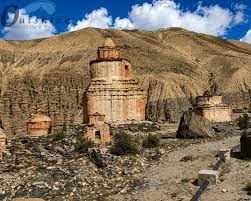
Samdzong Cave: Mustang's 3,000-Year Salt Traders

August 18, 2026

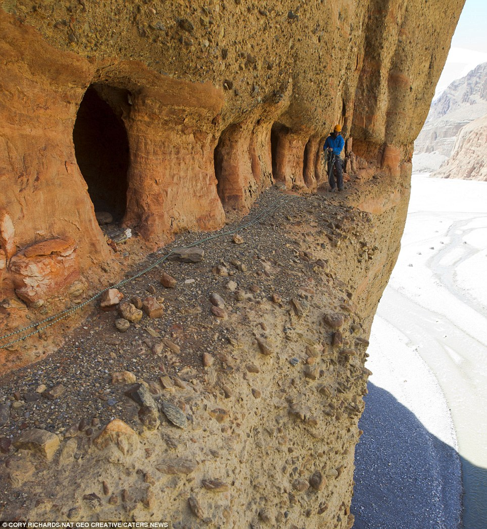
Samdzong, located in the remote highlands of Upper Mustang in Nepal, is one of the most remarkable archaeological landscapes in the Himalayas. The site is associated with ancient funerary caves and tombs positioned dramatically within the cliffs of the Kali Gandaki region. Archaeological discoveries there have revealed human remains, elaborate burial goods, gold masks, weapons, textiles, and other objects that provide rare evidence for life and death in the high Himalayas.

The title “Mustang's 3,000-Year Salt Traders” captures the broader historical importance of Mustang as a region connected to ancient trade routes. However, the archaeological evidence from Samdzong itself should be treated carefully. The excavated shaft tombs at Samdzong are primarily dated to the first millennium CE, especially between approximately the fifth and seventh centuries, while Mustang as a wider archaeological landscape contains evidence of much older human occupation and burial traditions. The Kali Gandaki corridor was also historically an important route linking the Tibetan Plateau with regions farther south, and salt was among the commodities that moved through these mountain networks.

Samdzong is therefore important not simply because of one spectacular archaeological discovery, but because it stands at the intersection of several major historical themes: high-altitude settlement, mortuary traditions, long-distance exchange, and the movement of people and materials through one of the world's most challenging landscapes.

The Landscape of Upper Mustang

Upper Mustang lies within the rain shadow of the Himalayas, creating a cold and relatively dry environment that differs dramatically from the greener regions of Nepal farther south.

The Kali Gandaki River runs through this landscape, forming a natural corridor between the Tibetan Plateau and the lower Himalayan regions.

For thousands of years, this corridor offered one of the most important routes through the mountains.

People moving through the region could transport goods such as:

  • salt;

  • grain;

  • wool;

  • animal products;

  • textiles;

  • metals;

  • spices;

  • and other valuable commodities.

The importance of the region as a communication route helps explain why human communities could survive and develop in such an apparently difficult environment. Mustang was not isolated from the wider world. Instead, its mountain valleys connected different cultural and economic zones.

The Discovery of the Samdzong Tombs

The archaeological significance of Samdzong became dramatically apparent after a seismic event damaged part of the cliff and exposed previously hidden tomb chambers.

Archaeological investigations revealed a complex of shaft tombs cut into the cliff environment.

The tombs were situated at an altitude of roughly 4,000 meters, making them among the most remarkable high-altitude mortuary sites studied in the Himalayas.

The discovery demonstrated that communities living in Upper Mustang possessed complex traditions concerning death and burial. These were not simple, isolated graves. Some chambers contained multiple individuals and a diverse collection of objects. Archaeological research indicates that the Samdzong tomb complex was used over several centuries, with most interments concentrated broadly within the middle of the first millennium CE.

A Community Burial Landscape

The Samdzong tombs appear to have served as collective mortuary spaces.

Rather than containing only a single elite individual, some chambers contained the remains of numerous people.

The archaeological evidence includes individuals of different ages and both sexes, indicating that the burial system served a broader community.

The dead were accompanied by objects that included both practical and prestigious materials.

These discoveries provide important information about:

  • population structure;

  • mortuary customs;

  • social relationships;

  • trade connections;

  • and technological practices.

The use of collective burial spaces also demonstrates that death was not merely an individual event. Burial may have reinforced relationships between families, communities, ancestors, and the wider social world.

Gold Masks and Elite Burial Objects

Among the most remarkable discoveries from Samdzong were metal artifacts, including gold and silver masks, copper vessels, iron daggers, brass ornaments, and other objects.

These discoveries demonstrate that even remote Himalayan communities participated in wider networks through which materials, technologies, and artistic styles circulated.

The presence of gold masks is particularly significant.

Gold is a prestige material that requires access to valuable resources and skilled craftspeople. The masks found at Samdzong also show stylistic relationships with objects from other parts of the Himalayan and Inner Asian world.

This suggests that the people of Upper Mustang were connected to broader cultural networks rather than living in complete isolation.

Metal Technology in the High Himalayas

The Samdzong artifacts demonstrate considerable technological diversity.

Archaeologists recovered objects made from:

  • gold;

  • silver;

  • copper-based alloys;

  • iron;

  • and other materials.

The production and acquisition of these objects required complex systems.

Metalworking involved:

  1. obtaining raw materials;

  2. processing ores or acquiring finished metals;

  3. producing tools and molds;

  4. heating and shaping the materials;

  5. and distributing the finished objects.

Not every object necessarily had to be manufactured locally. Some could have arrived through exchange.

This distinction is important because trade routes could move finished goods as well as raw materials.

Mustang and the Ancient Salt Trade

Salt was one of the most valuable commodities in many premodern mountain economies.

It was essential for human and animal health and could also be used in food preservation.

In the Himalayan world, areas of the Tibetan Plateau possessed access to salt resources, while communities farther south had agricultural products that could be exchanged.

This created economic relationships in which caravans moved across mountain passes carrying different goods.

Mustang became historically important because the Kali Gandaki corridor connected the Tibetan world with Nepal and regions farther south.

The Kora La pass and other routes enabled the movement of people and goods across the Himalayas. Over long periods, Mustang became associated with trade in salt, grain, wool, dried foods, and other products.

Life at High Altitude

Living at approximately 4,000 meters above sea level required extensive adaptation.

Communities had to manage:

  • low oxygen levels;

  • cold temperatures;

  • limited agricultural land;

  • difficult transportation;

  • and seasonal changes.

Archaeological evidence from the wider Mustang region indicates that communities combined different strategies for survival.

These could include:

  • agriculture in suitable areas;

  • animal husbandry;

  • seasonal movement;

  • trade;

  • and the careful management of limited resources.

Research on Himalayan burial sites has also shown that communities in the region cultivated crops such as barley and buckwheat while maintaining livestock adapted to high-altitude conditions.

The Importance of Trade Networks

The objects found at Samdzong reveal that high-altitude communities could participate in surprisingly extensive exchange networks.

A mountain settlement did not need to produce every material it used.

Instead, communities could exchange local resources and agricultural products for goods obtained from distant regions.

Trade could move:

  • metals;

  • ornaments;

  • glass;

  • textiles;

  • salt;

  • livestock products;

  • and ceremonial objects.

These networks connected Mustang with the Tibetan Plateau, South Asia, and other parts of Inner Asia.

Archaeology and the Problem of Preservation

Samdzong also demonstrates the vulnerability of archaeological sites.

The cliff environment that protected the tombs for centuries could also become dangerous.

Earthquakes and natural erosion can damage burial chambers and disturb the original arrangement of objects and human remains.

Once archaeological context is disturbed, interpretation becomes more difficult.

Researchers must carefully reconstruct:

  • where objects originally came from;

  • whether they were placed intentionally;

  • how chambers were organized;

  • and how later events altered the evidence.

Why Samdzong Matters

Samdzong provides rare evidence for the prehistoric and early historical communities of the Himalayas.

The site demonstrates that mountain populations possessed:

  • complex burial traditions;

  • access to prestige materials;

  • connections to long-distance trade;

  • sophisticated metal objects;

  • and social systems capable of maintaining collective mortuary spaces.

The discovery challenges the idea that high mountain communities were isolated or culturally simple.

Conclusion

Samdzong is a remarkable archaeological window into the ancient human world of Upper Mustang.

Its tombs, human remains, gold masks, metal objects, and other artifacts reveal communities connected to wider systems of trade and cultural exchange.

Although the site's famous tomb complex should not be simplified into a literal 3,000-year-old salt-trading settlement, Mustang itself had a much deeper prehistoric history and became an important corridor for movement between Tibet and South Asia.

Samdzong reminds us that even in the extreme landscapes of the Himalayas, human communities built networks, maintained traditions, buried their dead with elaborate objects, and participated in a world far larger than their mountain valleys.

Lo Manthang: Mustang's Hidden Cliffside Kingdom

August 18, 2026

Lo Manthang is one of the most extraordinary historic settlements in the Himalayas. Located in Upper Mustang, northern Nepal, it served as the capital of the former Kingdom of Lo and remains one of the best-preserved walled settlements of the Tibetan cultural world.

Although it is sometimes romantically described as a “hidden kingdom,” Lo Manthang was never historically isolated in the absolute sense. Its location along important mountain routes gave it strategic and economic importance. The city developed within a wider network connecting the Tibetan Plateau, Nepal, and South Asia.

Constructed during the fifteenth century at an elevation of approximately 3,800 meters, Lo Manthang became the political, religious, and cultural center of the Kingdom of Lo. Its earthen walls, palace, monasteries, compact houses, religious monuments, and surrounding agricultural landscape preserve an exceptional example of a Himalayan urban settlement.

The Founding of the Kingdom of Lo

The Kingdom of Lo emerged during the fifteenth century under its founder, Ame Pal.

The creation of a political center in Upper Mustang reflected the strategic importance of the region.

Control over Mustang meant influence over mountain routes connecting Tibet and Nepal.

The kingdom developed its own political identity while maintaining strong cultural relationships with the Tibetan world.

Lo Manthang became the royal capital and the symbolic center of the kingdom.

A Walled City in the Himalayas

One of the most distinctive features of Lo Manthang is its defensive wall.

The settlement is surrounded by a substantial earthen enclosure approximately six meters high, reinforced with towers at strategic points.

Within the walls, houses and religious buildings form a compact urban landscape.

The wall served several possible purposes.

It could provide:

  • defense;

  • protection from conflict;

  • control over movement;

  • symbolic separation between the capital and surrounding settlements;

  • and protection in the harsh mountain environment.

The existence of a fortified capital demonstrates the political organization and resources of the Kingdom of Lo.

Building with Earth

Lo Manthang's architecture reflects the materials available in its high-altitude environment.

Many structures were constructed using earth-based techniques.

Building with earth required extensive knowledge.

Workers had to understand:

  • the properties of local soils;

  • methods of compaction;

  • wall thickness;

  • protection against water damage;

  • and maintenance.

Earthen architecture can survive for centuries in dry climates, but it requires continual care.

Rain, snow, wind, earthquakes, and modern development can all threaten historic structures.

The Royal Palace

The royal palace of Lo Manthang served as a symbol of political authority.

A palace was not simply a residence.

It could also function as a center for:

  • administration;

  • ceremonies;

  • meetings;

  • storage;

  • and royal representation.

Its location within the walled settlement reinforced the relationship between political power and urban space.

Buddhist Monasteries

Religion formed a central part of life in Lo Manthang.

The city contains important Buddhist monasteries, including Jampa Lhakhang and Thubchen Lhakhang, associated with the early history of the settlement.

These monasteries preserve important artistic and religious traditions.

They contain:

  • religious paintings;

  • sculptures;

  • ritual spaces;

  • and architectural features connected with Tibetan Buddhist practice.

The religious institutions of Lo Manthang were closely connected with the cultural traditions of Tibet, particularly the Sakya tradition of Tibetan Buddhism.

The Importance of Wall Paintings

Himalayan monasteries often preserve elaborate murals.

These paintings could depict:

  • Buddhas;

  • bodhisattvas;

  • protective deities;

  • religious teachers;

  • cosmological scenes;

  • and complex narrative traditions.

The creation of a mural required specialized knowledge of pigments, preparation of wall surfaces, composition, and religious iconography.

Because paintings are vulnerable to moisture, smoke, structural damage, and human activity, their preservation requires careful conservation.

Lo Manthang and the Salt Routes

The historical importance of Lo Manthang was closely related to Mustang's position along routes connecting Tibet and Nepal.

Trade across the Himalayas involved the exchange of complementary resources.

Goods moving through the region included:

  • salt;

  • grain;

  • wool;

  • livestock products;

  • textiles;

  • and other commodities.

The kingdom benefited from its location near these routes.

Trade brought not only wealth but also information, artistic influences, religious ideas, and connections with distant communities.

Agriculture in a High-Altitude Kingdom

Despite its dramatic desert-like landscape, Upper Mustang supported agricultural communities.

Fields were cultivated where water could be controlled through irrigation.

Agriculture required careful management because the growing season was limited.

Communities needed to coordinate:

  • irrigation;

  • planting;

  • harvesting;

  • food storage;

  • and the use of scarce land.

Barley and other hardy crops could be particularly important in such environments.

A Living Tibetan Cultural Landscape

Lo Manthang is not merely an archaeological ruin.

It remains part of a living cultural landscape.

The people of the region maintain traditions shaped by centuries of interaction with the Tibetan world.

Religious festivals, rituals, architecture, language, and social practices continue to give the settlement cultural significance.

This creates a special challenge for preservation.

Conservation must protect historic structures while respecting the fact that communities continue to live and worship within them.

Isolation and Preservation

Upper Mustang remained highly restricted to outside visitors until 1992.

This relative isolation contributed to the preservation of many traditional cultural features.

However, preservation does not mean that the region remained unchanged.

Modern roads, tourism, construction, migration, and economic change continue to influence the area.

The challenge is to manage these changes without destroying the cultural heritage that makes Lo Manthang unique.

Why Lo Manthang Matters

Lo Manthang is important because it preserves an unusually complete example of a historic Himalayan capital.

Its significance includes:

  • fortified urban planning;

  • earthen architecture;

  • royal political history;

  • Tibetan Buddhist monuments;

  • trade-route connections;

  • and living cultural traditions.

The settlement provides an exceptional opportunity to study how political authority, religion, architecture, and trade were connected in the Himalayan world.

Conclusion

Lo Manthang was the capital of a mountain kingdom, but it was also a crossroads.

Its walls protected a compact city of houses, monasteries, and royal institutions, while the trade routes surrounding it connected Upper Mustang with Tibet and South Asia.

Today, Lo Manthang remains one of the most remarkable historic settlements in the Himalayas. Its survival allows modern visitors and researchers to encounter a living cultural landscape shaped by the political ambitions, religious traditions, environmental adaptations, and trade networks of centuries

Tsarang Monastery: Mustang's Medieval Wall Paintings

August 18, 2026

Tsarang, also spelled Charang, is one of the major historic settlements of Upper Mustang and an important center of Tibetan Buddhist culture. Located along the route between southern Mustang and Lo Manthang, the settlement developed as part of the political and religious landscape of the former Kingdom of Lo.

The title “Tsarang Monastery” can refer broadly to the religious heritage of the settlement, which includes historically important monastic architecture and painted interiors. Medieval Himalayan wall paintings are particularly valuable because they preserve complex visual traditions associated with Buddhism, royal patronage, regional artistic exchange, and religious practice.

The study of Tsarang's religious heritage also helps explain how the Kingdom of Lo maintained cultural connections with Tibet while developing its own political identity within the Himalayan landscape.

Tsarang in the Kingdom of Lo

Tsarang occupied an important position within Upper Mustang.

The settlement lay along routes connecting different villages and eventually the royal capital at Lo Manthang.

As the Kingdom of Lo developed during the fifteenth century, religious institutions became closely connected with political authority.

Monasteries were not merely places for private worship.

They could function as centers of:

  • education;

  • manuscript preservation;

  • artistic production;

  • ritual activity;

  • and community organization.

The Role of Monasteries

A Buddhist monastery required a complex network of people and resources.

Monks and religious specialists needed support from local communities and political patrons.

The construction and maintenance of a monastery involved:

  • architects;

  • builders;

  • carpenters;

  • painters;

  • sculptors;

  • donors;

  • and religious authorities.

This made monasteries important institutions within the social and economic life of the region.

The Art of Himalayan Wall Painting

Wall paintings were among the most visually powerful forms of religious expression.

Artists could cover temple interiors with complex scenes representing Buddhist cosmology.

Common subjects included:

  • Buddhas;

  • bodhisattvas;

  • lineage teachers;

  • protective deities;

  • mandalas;

  • religious narratives;

  • and symbolic landscapes.

These images were not simply decorative.

They formed part of the religious environment in which rituals and meditation took place.

Preparing a Painted Wall

The creation of a mural involved several stages.

First, the wall surface had to be prepared.

Layers of plaster or fine finishing materials could create a suitable painting surface.

Artists then planned the composition.

Major figures and geometric structures needed to be positioned according to established religious conventions.

Pigments were applied using mineral and organic materials available through local or long-distance supply networks.

Religious Iconography

Buddhist images followed systems of symbolism.

The position of a figure, the objects held in its hands, the color of its body, and its relationship to surrounding figures could all carry meaning.

A religious artist therefore needed more than technical skill.

The artist also needed knowledge of iconographic traditions.

In some cases, painters worked according to detailed visual models transmitted across generations.

Connections with Tibetan Art

Upper Mustang belonged to a wider cultural world shaped by the Tibetan Plateau.

Artistic traditions could travel through:

  • monasteries;

  • pilgrimage;

  • trade;

  • royal patronage;

  • and the movement of artists.

The wall paintings of Mustang therefore form part of a broader Himalayan artistic history.

At the same time, local artists could adapt imported traditions to local materials and regional preferences.

The Importance of Preservation

Ancient wall paintings are extremely fragile.

They can be damaged by:

  • water infiltration;

  • earthquakes;

  • smoke;

  • insects;

  • temperature changes;

  • structural collapse;

  • and human contact.

Conservation is therefore a complicated process.

Restorers must stabilize damaged areas without erasing evidence of the original artwork.

Modern conservation also involves documentation so that future researchers can study the paintings even if parts of the original surface deteriorate.

Monasteries as Historical Archives

Monasteries can preserve more than paintings.

They may contain:

  • manuscripts;

  • religious sculptures;

  • ritual objects;

  • historical records;

  • and donated objects.

Together, these materials provide evidence for political and religious relationships across the Himalayan world.

A monastery can therefore function as an archive of centuries of cultural history.

Tsarang and the Trade Routes

The cultural development of Tsarang was influenced by Upper Mustang's position along mountain routes.

Trade allowed communities to obtain materials that were not locally available.

These could include:

  • pigments;

  • paper;

  • metals;

  • textiles;

  • and luxury objects.

The movement of merchants and pilgrims also encouraged the circulation of artistic and religious ideas.

Why Tsarang's Wall Paintings Matter

Medieval wall paintings provide direct evidence of how people visualized the religious universe.

They reveal:

  • artistic techniques;

  • theological ideas;

  • regional styles;

  • systems of patronage;

  • and cultural interaction.

Because Mustang's environment is relatively dry, some historic structures and paintings have survived that might have deteriorated more quickly elsewhere.

Conclusion

The religious heritage of Tsarang preserves an important chapter in the artistic history of Upper Mustang.

Its monastic traditions and painted interiors demonstrate the close relationship between Buddhism, political authority, artistic production, and community life.

The murals are not simply beautiful historical objects. They are visual records of a religious world shaped by centuries of interaction between the Kingdom of Lo, Tibet, and the wider Himalayan region.

Sky Caves of Nepal: Mustang's 2,500-Year Looted Tombs

August 18, 2026

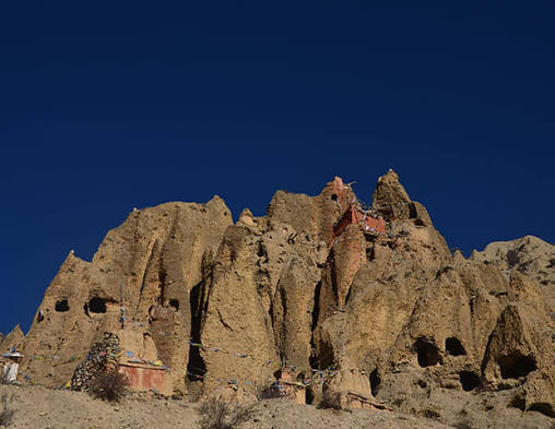
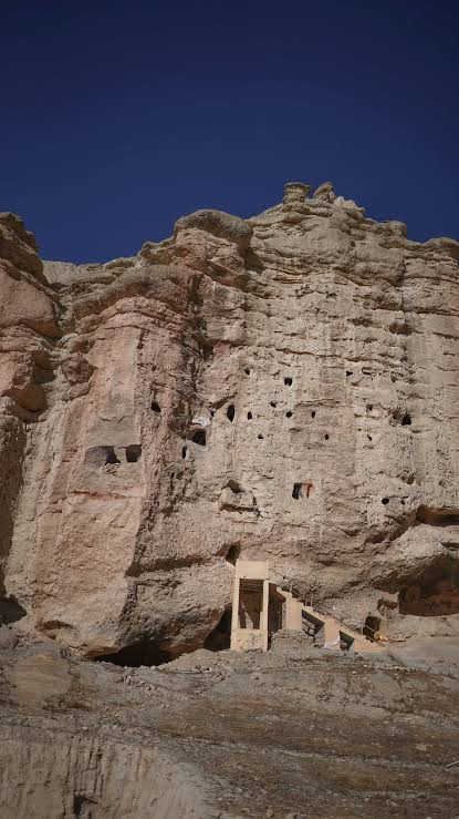
The Sky Caves of Mustang are among the most mysterious archaeological landscapes in the Himalayas. Thousands of artificial caves have been carved into the steep cliffs of Upper Mustang, often at heights that appear almost impossible to reach without modern climbing equipment.

These caves have served different purposes during different periods.

Some were used as:

  • homes;

  • storage spaces;

  • defensive refuges;

  • monasteries;

  • meditation chambers;

  • and burial sites.

Their history extends across thousands of years, making the Mustang cave landscape one of the most important long-term archaeological records in the Himalayan region. Investigations have identified human remains and other evidence dating back more than two thousand years, while later caves contain Buddhist art, manuscripts, and artifacts from medieval periods.

A Landscape of Thousands of Caves

Estimates commonly describe the Mustang region as containing roughly ten thousand man-made caves distributed across cliff faces and valleys.

The caves were created by cutting into relatively soft rock formations.

Some form isolated chambers, while others are organized into complex, multi-level systems.

The sheer scale of this artificial landscape raises important questions.

Who created these caves?

How were they originally accessed?

Why were some constructed so high above the valley floor?

Archaeologists continue to investigate these questions.

Why Were the Caves Built So High?

The extreme location of many caves is one of their greatest mysteries.

Several explanations have been proposed depending on the specific site.

High caves could offer:

  • protection from enemies;

  • secure storage;

  • isolation for religious activity;

  • protection from flooding or animals;

  • or special locations for burial.

Access may originally have been provided by:

  • wooden ladders;

  • scaffolding;

  • platforms;

  • rope systems;

  • or routes that have since disappeared.

Erosion and the collapse of surrounding rock can make ancient access routes impossible to reconstruct.

The Earliest Burials

Some Mustang caves contain human remains dating back thousands of years.

One of the most important discoveries occurred at Mebrak, where archaeologists found naturally mummified bodies preserved in the dry and cold conditions of a high-altitude burial cave.

Radiocarbon dating showed that the burial chamber was used over several centuries, beginning around the middle of the first millennium BCE.

The dry climate preserved not only human remains but also wooden coffins, textiles, animal remains, and everyday objects.

These discoveries demonstrate that Mustang's caves formed part of organized prehistoric mortuary traditions.

Naturally Preserved Himalayan Mummies

Mummification in Mustang was often a natural process rather than an intentional artificial procedure like the embalming traditions of ancient Egypt.

Cold temperatures, dry air, and limited moisture slowed the decomposition of bodies.

This allowed skin, hair, textiles, and other organic materials to survive.

The preservation of such materials provides archaeologists with unusually detailed evidence about prehistoric life.

Researchers can study:

  • clothing;

  • burial objects;

  • woodworking;

  • food remains;

  • physical health;

  • and community structure.

The Problem of Looting

Unfortunately, many archaeological sites in Mustang have been disturbed.

Looting can cause permanent damage because the value of an archaeological object depends heavily on its context.

A gold ornament removed from a tomb may be visually impressive, but archaeologists lose important information when they do not know:

  • where it was found;

  • what it was placed beside;

  • which burial it belonged to;

  • and how it was originally arranged.

Research into Himalayan archaeological sites has documented cases in which caves and burial contexts were disturbed by looting, erosion, construction, and other processes.

What Makes a Tomb Important?

An ancient tomb is not simply a container filled with valuable objects.

Its importance lies in the relationships between all of its components.

Archaeologists examine:

  • the position of the body;

  • the arrangement of grave goods;

  • the architecture of the chamber;

  • the sequence of burials;

  • and evidence of later disturbance.

This context can reveal information about religion, family relationships, social status, and attitudes toward death.

Looting destroys many of these relationships.

From Tombs to Homes

The remarkable feature of the Mustang cave landscape is that caves could change their purpose over time.

A space originally created for one activity could later be reused.

For example, a cave might have served as:

  1. a burial chamber;

  2. later a refuge;

  3. and eventually a religious retreat or storage area.

This reuse makes interpretation complicated but also fascinating.

The cave landscape is a record of changing human relationships with the environment.

Buddhist Caves and Medieval Art

By the medieval period, some caves in Mustang were associated with Buddhist religious activity.

Explorations have uncovered:

  • wall paintings;

  • sculptures;

  • manuscripts;

  • pottery;

  • and other religious objects.

These discoveries demonstrate that the cave landscape remained important long after the earliest prehistoric burials.

Some sites preserve evidence of artistic traditions connected with the wider Tibetan Buddhist world.

Archaeology in an Extreme Environment

Investigating the Sky Caves is physically demanding.

Many chambers can only be reached using ropes and climbing equipment.

Archaeologists must transport:

  • excavation equipment;

  • cameras;

  • recording devices;

  • conservation materials;

  • and scientific samples

into difficult locations.

The danger of falling rocks and unstable cliff faces adds another challenge.

Why the Sky Caves Matter

The Sky Caves provide evidence for an extraordinarily long history of human activity in Mustang.

They allow researchers to study:

  • prehistoric burial traditions;

  • natural mummification;

  • high-altitude settlement;

  • defensive architecture;

  • religious transformation;

  • medieval Buddhist art;

  • and long-distance cultural interaction.

Few archaeological landscapes contain such a long sequence of changing human activity within the same dramatic environment.

Conclusion

The Sky Caves of Mustang are far more than mysterious holes carved into Himalayan cliffs.

They preserve the traces of thousands of years of human history.

Within their chambers, archaeologists have found the dead, the objects of daily life, religious paintings, manuscripts, and evidence of communities that learned to survive in one of the world's most difficult environments.

Looting and natural erosion remain serious threats, but continuing archaeological research is gradually revealing the remarkable history hidden within the cliffs of Upper Mustang.

Chhoser: Mustang's Cliff Fortress Ruins

August 18, 2026

Chhoser, located in Upper Mustang near Lo Manthang, is part of the extraordinary archaeological and historical landscape of the former Kingdom of Lo. The region is known for its dramatic cliffs, cave complexes, religious monuments, and settlements that demonstrate how human communities adapted to the difficult environment of the trans-Himalayan plateau.

The title “Cliff Fortress Ruins” reflects the defensive and strategic character of Mustang's cliff landscapes. Throughout the region, people used natural rock formations and artificial caves for settlement, refuge, storage, and protection during periods of instability.

Chhoser is therefore best understood as part of a larger landscape in which geography itself influenced architecture and political security.

The Geography of Chhoser

Upper Mustang is characterized by:

  • deeply eroded valleys;

  • steep cliffs;

  • high-altitude plateaus;

  • dry landscapes;

  • and narrow routes through the mountains.

These geographical features could create natural defensive advantages.

A settlement positioned above a valley could observe approaching travelers.

Cliffs could also provide locations that were difficult for enemies to reach.

In such an environment, architecture and geography often became closely connected.

Caves as Defensive Spaces

Many caves in Mustang were carved into cliffs.

Some were probably used as:

  • homes;

  • storage areas;

  • burial chambers;

  • meditation retreats;

  • and refuges.

During periods of conflict, a high cave could provide protection from attack.

Access could potentially be controlled through ladders, narrow paths, or removable wooden structures.

The same cave system could therefore serve both peaceful and defensive purposes at different times.

What Makes a Fortress?

A fortress does not always need massive stone walls.

In mountainous environments, natural geography can become part of the defensive system.

A defensible location may include:

  • steep slopes;

  • narrow entrances;

  • elevated observation points;

  • restricted access routes;

  • and protected water or food storage.

Communities could modify these natural features with walls, gates, platforms, or caves.

Mustang and Political Competition

The history of the Himalayan region involved shifting political relationships between local communities, Tibetan powers, and neighboring states.

Control over trade routes could be economically valuable.

Mountain passes were not merely geographical obstacles; they were strategic corridors.

A community capable of controlling a route could influence the movement of:

  • merchants;

  • livestock;

  • armies;

  • pilgrims;

  • and valuable goods.

This made fortified settlements important.

Cave Architecture

Creating an artificial cave required significant labor.

Workers had to remove rock using available tools while ensuring that the remaining structure was stable.

Multi-level cave systems could include:

  • living spaces;

  • storage chambers;

  • corridors;

  • and specialized rooms.

Some Mustang caves are now extremely difficult to access because original routes have collapsed or eroded.

This creates one of archaeology's greatest challenges: reconstructing how ancient people originally entered and used the spaces.

Chhoser and the Kingdom of Lo

Chhoser belonged to the cultural and political landscape surrounding Lo Manthang.

The region's settlements were connected through local routes and shared religious and social traditions.

As the Kingdom of Lo developed, the relationship between the royal capital and surrounding villages became part of a larger political system.

Chhoser therefore cannot be separated from the broader history of Upper Mustang.

Archaeological Preservation

Cliffside sites face several threats.

Natural processes include:

  • erosion;

  • earthquakes;

  • rockfalls;

  • wind damage;

  • and water infiltration.

Human threats can include:

  • looting;

  • uncontrolled tourism;

  • construction;

  • and the removal of artifacts.

Once a cave is disturbed, valuable information about its original use can be lost.

Why Cliff Fortresses Fascinate Archaeologists

Defensive sites provide evidence for how ancient communities understood danger.

The decision to construct or occupy a difficult location required effort.

People may have been responding to:

  • warfare;

  • raiding;

  • political instability;

  • or competition for resources.

However, archaeologists must avoid assuming that every elevated site was automatically a fortress.

A high location could also have religious, economic, or environmental advantages.

Only detailed study of architecture and archaeological evidence can determine how a specific site was used.

Chhoser as Part of a Cultural Landscape

The greatest importance of Chhoser lies in its relationship to the surrounding landscape.

Cliffs, caves, monasteries, villages, and trade routes together create a complex historical environment.

People did not experience these features separately.

A journey through Upper Mustang might connect:

  • a village;

  • agricultural fields;

  • a religious monument;

  • a trade route;

  • and a defensive refuge.

The entire landscape was part of everyday life.

Conclusion

Chhoser represents the remarkable relationship between people and landscape in Upper Mustang.

Its cliffside environment demonstrates how natural geography could influence settlement, security, architecture, and cultural identity.

Whether used for habitation, storage, religious activity, or defense, the caves and ruins associated with this Himalayan landscape preserve evidence of communities that transformed seemingly inaccessible mountains into places where people could live, worship, trade, and survive.

Yara: Mustang's Hanging Salt Village

August 18, 2026

Yara is one of the historic settlements of Upper Mustang, located within the dramatic dry valleys and cliffs of Nepal's trans-Himalayan region. Like other communities in Mustang, Yara developed within a landscape shaped by high altitude, limited agricultural land, mountain trade, and strong cultural connections with Tibet.

The phrase “Hanging Salt Village” captures the dramatic appearance of settlements and cave systems positioned near cliffs and steep landscapes, as well as Mustang's historical association with trans-Himalayan trade. Salt was one of the commodities that moved through the wider Kali Gandaki trade corridor, although Yara itself should be understood as part of a larger network rather than assumed to have been exclusively a salt-trading settlement.

The history of Yara reflects a broader human achievement: the ability of communities to establish permanent settlements in environments that appear, at first glance, almost impossible to inhabit.

The Environment of Upper Mustang

Upper Mustang lies in the rain shadow of the Himalayas.

The region receives far less rainfall than many other parts of Nepal.

Its landscape is characterized by:

  • dry valleys;

  • eroded cliffs;

  • sparse vegetation;

  • high-altitude plateaus;

  • and dramatic mountain scenery.

Water is therefore a critical resource.

Where reliable water sources exist, communities can create agricultural land through irrigation.

Agriculture in a Mountain Desert

Farming in Upper Mustang requires careful environmental management.

Communities cannot depend solely on rainfall.

Irrigation systems help direct water from streams and snowmelt toward cultivated fields.

Farmers must coordinate:

  • the maintenance of channels;

  • planting schedules;

  • water distribution;

  • harvesting;

  • and food storage.

The limited growing season makes successful agriculture particularly important.

Hardy crops such as barley have historically been well suited to high-altitude environments.

Yara and the Cave Landscape

The region surrounding Yara is part of Mustang's larger landscape of cliffs and artificial caves.

These caves demonstrate the ability of ancient and medieval communities to adapt architecture to their environment.

Depending on the site, caves could provide:

  • shelter;

  • storage;

  • burial space;

  • religious retreats;

  • and defensive refuge.

The presence of caves near settlements illustrates how people used both constructed buildings and natural geological features.

Why Build into the Cliffs?

Cliffside spaces offered several advantages.

They could be:

  • protected from strong winds;

  • naturally insulated;

  • difficult to access;

  • and located above flood-prone areas.

At the same time, building and maintaining access to high caves required significant labor and skill.

The original systems of ladders, walkways, or climbing routes may no longer survive.

Salt and the Mountain Economy

Salt played a crucial role in traditional Himalayan exchange.

Communities on the Tibetan Plateau had access to salt resources, while agricultural regions farther south produced grain and other goods.

This encouraged trade across mountain passes.

Caravans could transport:

  • salt;

  • wool;

  • grain;

  • dried meat;

  • animal products;

  • textiles;

  • and other materials.

Mustang's location along routes between Tibet and Nepal made the entire region an important participant in these exchange systems.

Life Along the Trade Routes

Trade routes brought more than goods.

They also encouraged the movement of:

  • languages;

  • religious ideas;

  • artistic styles;

  • technologies;

  • and people.

A remote village could therefore participate indirectly in events occurring hundreds of kilometers away.

Merchants, pilgrims, herders, and political representatives could all travel through the broader Mustang corridor.

Houses and Settlement Organization

Traditional highland settlements were generally organized around practical environmental needs.

Homes needed protection from:

  • cold;

  • wind;

  • limited fuel resources;

  • and seasonal weather.

Construction materials often came from the local environment.

Stone, earth, timber, and other available resources could be combined to create durable buildings.

The organization of a village also reflected social relationships.

Families needed access to:

  • water;

  • agricultural fields;

  • grazing areas;

  • religious institutions;

  • and routes connecting them to neighboring communities.

Religion and Tibetan Cultural Influence

Upper Mustang developed strong cultural connections with Tibet.

Buddhist monasteries, stupas, prayer walls, and religious monuments became important features of the regional landscape.

Religion shaped:

  • festivals;

  • artistic traditions;

  • burial customs;

  • social organization;

  • and relationships between communities.

Even remote settlements were connected to broader religious networks.

Yara and Archaeological Change

Historic villages are not frozen in time.

Over centuries, populations can:

  • move;

  • expand;

  • abandon old houses;

  • build new structures;

  • or change economic strategies.

Environmental pressures and political changes can also transform settlements.

Archaeological remains surrounding modern communities may therefore represent several different periods of occupation.

The Challenge of Preservation

The heritage of Mustang faces significant pressures.

Ancient caves and historic settlements can be damaged by:

  • earthquakes;

  • erosion;

  • climate-related changes;

  • tourism;

  • road construction;

  • and the gradual abandonment of traditional buildings.

Preserving these landscapes requires more than protecting individual monuments.

It requires understanding the relationship between villages, agricultural systems, religious sites, and the surrounding environment.

Why Yara Matters

Yara represents the human history of adaptation in the Himalayan highlands.

Its importance lies in its connection to:

  • high-altitude settlement;

  • cliffside architecture;

  • agricultural adaptation;

  • Tibetan cultural traditions;

  • and long-distance trade.

The settlement also forms part of the larger archaeological landscape of Upper Mustang, where evidence of human activity extends from prehistoric periods to the medieval Kingdom of Lo and beyond.

Conclusion

Yara's dramatic landscape reflects the extraordinary ability of human communities to create permanent homes in difficult environments.

Through irrigation, agriculture, trade, architecture, and cultural cooperation, the people of Upper Mustang transformed dry mountain valleys into inhabited landscapes.

The history of Yara cannot be separated from the wider history of Mustang's trade routes, cliffside caves, Buddhist traditions, and highland communities.

Its story is ultimately one of adaptation and connection: a mountain settlement shaped by its seemingly remote location yet linked for centuries to the wider worlds of Tibet, Nepal, and the Himalayan trade networks.

Paviland Cave: Wales' 33,000-Year Red Lady

August 15, 2026

Few archaeological discoveries demonstrate the changing nature of science as clearly as the Red Lady of Paviland.

When the skeleton was discovered in 1823 inside Goat's Hole Cave on the Gower Peninsula, the excavator, William Buckland, interpreted the remains according to the knowledge available at the time.

He believed the skeleton belonged to a woman.

Modern science eventually demonstrated that the individual was actually a young adult male.

Buckland also had no way to imagine that the remains were tens of thousands of years old.

Radiocarbon dating did not yet exist.

The concept of deep human prehistory was still developing.

Today, the Red Lady of Paviland is recognized as one of the most important Upper Paleolithic burials in Britain.

The Discovery in 1823

William Buckland discovered the remains in Goat's Hole Cave.

The skeleton was associated with red ochre and decorative materials.

The striking red coloration contributed to the name “Red Lady.”

The association with ornaments influenced Buckland's interpretation of the individual's sex.

Modern archaeology has demonstrated how dangerous such assumptions can be.

Objects do not automatically identify gender.

Cultural associations between ornaments and sex vary dramatically between societies.

The Red Lady Was a Young Man

Later osteological analysis established that the skeleton belonged to a young adult male.

The famous name remained, however.

The Red Lady is therefore one of archaeology's most famous misnomers.

The correction is historically important because it demonstrates how scientific interpretations change.

The skeleton did not change.

The evidence available to researchers changed.

The methods improved.

And the interpretation became more accurate.

The Meaning of Red Ochre

Red ochre is an iron-rich pigment that has been used by human populations for extremely long periods.

It can be ground into powder and applied to skin, objects, surfaces, or the dead.

Its use in burials often suggests symbolic behavior.

However, archaeology cannot automatically explain the symbolism.

The color red may have represented life.

Blood.

Identity.

Transformation.

Ancestry.

Or something entirely different.

The people who buried the individual left no written explanation.

The pigment provides evidence of deliberate action—not a direct translation of belief.

A Deliberate Burial

The archaeological context suggests that the remains were treated intentionally.

The individual was associated with decorative materials and pigment.

This demonstrates that Upper Paleolithic communities practiced complex treatment of at least some members of society.

The burial may have involved ceremony.

It may have reflected social identity.

It may have expressed beliefs about death.

But the precise ritual remains unknown.

How Old Is the Red Lady?

The age of the burial has been revised as scientific methods improved.

Popular accounts often use an approximate age of around 33,000 years.

However, archaeological dating requires careful distinction between radiocarbon years and calibrated calendar years.

Modern research has refined the chronology and placed the burial within the Early Upper Paleolithic.

Regardless of the exact numerical framework used, the discovery remains among the oldest and most significant ceremonial human burials known from Britain.

Britain During the Ice Age

The Paviland burial belongs to a Britain radically different from today.

Sea levels were lower.

Britain was connected to continental Europe during portions of the Ice Age.

The environment experienced major climatic fluctuations.

The people who occupied the region were mobile hunter-gatherers.

They depended on detailed knowledge of animals, landscapes, seasons, and available resources.

The burial therefore occurred in a world without agriculture, cities, writing, or permanent states.

Yet the evidence demonstrates symbolic complexity.

Why the Ornaments Matter

Personal ornaments are among the strongest archaeological indicators of symbolic identity.

An ornament can communicate information.

It may indicate:

  • Membership in a group

  • Social status

  • Age

  • Personal identity

  • Cultural affiliation

  • Ritual significance

But archaeologists must be cautious.

An object does not come with a label explaining its meaning.

The same type of ornament could have different meanings in different societies.

The Importance of Paviland

Paviland is more than the story of one skeleton.

The wider site contains evidence relevant to:

  • Early modern human occupation

  • Upper Paleolithic technology

  • Symbolic behavior

  • Mortuary practices

  • Ice Age environments

The site has also played an important role in the history of archaeology itself.

The original interpretation was wrong.

Later science corrected it.

This process demonstrates one of the strengths of archaeology: conclusions are not sacred.

They can be challenged.

They can be revised.

Why the Red Lady Still Fascinates Us

Archaeologists now know far more about the skeleton than William Buckland could have imagined.

But the most important questions remain unanswered.

Who buried him?

Why was red ochre used?

What did the ornaments mean?

Was the burial connected with religious beliefs?

Was he an important individual?

The archaeological evidence can identify deliberate treatment.

It cannot fully reconstruct emotion.

Yet that limitation creates part of the site's power.

Thirty thousand years later, a young man remains anonymous.

His language is lost.

His beliefs are unknown.

But the people who buried him clearly did not treat his death as meaningless.

That human act of remembrance is what still connects Paviland to the present.

Gough's Cave: England's Cheddar Man Cannibals

August 15, 2026

Gough's Cave in Cheddar Gorge contains one of the most disturbing archaeological records in prehistoric Europe.

Around 14,700 years ago, Upper Paleolithic hunter-gatherers processed human bodies inside or in connection with the cave.

The bones reveal cut marks.

They were deliberately broken.

Some contain evidence consistent with human tooth marks.

And several human skulls were carefully modified into objects commonly described as skull-cups.

The evidence is so extensive that cannibalism is strongly supported.

But Gough's Cave is not simply a story about people eating other people.

It is a story about death, symbolism, ritual, and the limits of archaeological interpretation.

A Magdalenian World

The people associated with the most famous occupation of Gough's Cave belonged to the Late Upper Paleolithic cultural world often called the Magdalenian.

This period followed the harshest phases of the Last Glacial Maximum.

As environmental conditions changed, hunter-gatherer populations expanded into regions that had previously been less hospitable.

Britain was part of this changing landscape.

The people who entered Gough's Cave were skilled hunter-gatherers.

They possessed sophisticated knowledge of stone, bone, antler, animals, and landscapes.

The Human Bones

Archaeologists found the remains of multiple individuals.

The bones were fragmented and modified.

Scientific examination identified evidence including:

  • Stone-tool cut marks

  • Deliberate breakage

  • Tooth marks

  • Removal of soft tissue

  • Modification associated with marrow extraction

The treatment resembles the processing of animal remains found at the site.

This comparison is essential.

If human bones show the same sequence of butchery-related modifications as food animals, the interpretation of cannibalism becomes much stronger.

Why the Skull-Cups Matter

The modified skulls are among the most remarkable discoveries.

The cranial bones were carefully altered.

Their edges were shaped.

The resulting objects appear to have been deliberately transformed.

If the only objective had been nutrition, such additional work would not necessarily have been required.

This suggests that human consumption was connected with broader cultural practices.

The skulls were not simply discarded.

They were transformed.

Cannibalism and Ritual

The word “ritual” can sometimes become an easy explanation for anything archaeology cannot understand.

Therefore, it should be used carefully.

The evidence does not allow researchers to reconstruct a complete ceremony.

However, the combination of:

  • Cannibalistic processing

  • Skull modification

  • Deliberate engraving

  • Repeated treatment of human remains

strongly suggests that cultural meaning was involved.

The consumption of human bodies may have formed part of a mortuary tradition.

In other words, the dead may have been treated through practices that combined physical consumption and symbolic transformation.

The Engraved Human Bone

One of the most remarkable artifacts from Gough's Cave is an engraved human forearm bone.

The bone contains a deliberate zigzag pattern.

Microscopic examination distinguishes the engraving from ordinary butchery marks.

The sequence of modifications suggests that the bone passed through several stages.

The body was processed.

The bone was exposed.

The surface was engraved.

This demonstrates that human remains could become objects carrying additional meaning after death.

Was Cannibalism Caused by Starvation?

Probably not as a simple explanation.

The people of Gough's Cave had access to other food resources.

Animal remains demonstrate that the surrounding environment provided opportunities for hunting and subsistence.

This makes a purely starvation-based explanation less convincing.

Cannibalism may have involved nutritional motives, but the archaeological evidence suggests that it was embedded within a larger mortuary system.

Adults and Children

The human remains represent individuals of different ages.

This is important.

The treatment was not limited to a single adult victim.

The broader demographic evidence suggests a repeated or culturally structured practice rather than a simple isolated killing.

However, archaeology cannot determine the exact social relationship between all of the individuals.

Gough's Cave Is Not Cheddar Man

This distinction is essential.

The famous Cheddar Man was a Mesolithic individual who lived thousands of years later.

He was not one of the Magdalenian people associated with the cannibalistic remains.

The association between the two exists because both discoveries come from Cheddar Gorge.

Chronologically, however, they belong to very different prehistoric periods.

What Gough's Cave Teaches About Prehistoric People

The inhabitants of Gough's Cave cannot be reduced to the word “cannibals.”

They were skilled humans.

They hunted animals.

They manufactured tools.

They worked bone and antler.

They created symbolic objects.

They practiced complex treatment of the dead.

The archaeological evidence demonstrates that prehistoric human societies could combine activities that modern people often place into separate categories.

Food.

Death.

Art.

Ritual.

Identity.

These categories may have overlapped.

The Mystery That Remains

The bones tell archaeologists a great deal about what happened.

They are less capable of explaining why.

We can identify cut marks.

We can reconstruct the removal of flesh.

We can recognize deliberate skull modification.

But we cannot hear the beliefs of the people involved.

That silence is what makes Gough's Cave so unsettling.

The archaeological evidence is extraordinarily clear.

The human meaning behind it remains largely invisible.

Kendrick's Cave: Wales' Mesolithic Shell Midden

August 15, 2026

Kendrick's Cave in North Wales is an important archaeological site because it preserves evidence of prehistoric human activity in a region shaped by dramatic environmental change.

The cave is associated with material spanning important prehistoric transitions, and its archaeological record contributes to the study of hunter-gatherer communities in Wales.

The popular description of the site as simply a “Mesolithic shell midden” does not capture the full complexity of its archaeological significance.

Kendrick's Cave is better understood as part of a long prehistoric landscape repeatedly visited and used by human populations.

The Changing Landscape of North Wales

At the end of the last Ice Age, Britain underwent enormous environmental change.

Glaciers retreated.

Temperatures increased.

Forests expanded.

Sea levels rose.

Animals and human populations adapted.

The people living during the Mesolithic were hunter-gatherers, but they did not simply continue Paleolithic traditions unchanged.

They developed strategies suited to increasingly diverse environments.

What Is a Midden?

A midden is an accumulation of discarded material.

It may include:

  • Shells

  • Animal bones

  • Broken tools

  • Charcoal

  • Food remains

  • Other debris

A shell midden can reveal important information about diet and resource exploitation.

The presence of large quantities of shellfish demonstrates that prehistoric people understood how to exploit coastal or riverine environments.

Collecting shellfish could provide a relatively predictable food resource compared with the risks of hunting large mammals.

Hunter-Gatherer Diets Were Diverse

The stereotype of prehistoric people surviving exclusively by hunting large animals is inaccurate.

Hunter-gatherer communities used a wide variety of resources.

Depending on location and season, they could exploit:

  • Deer

  • Fish

  • Birds

  • Small mammals

  • Shellfish

  • Wild plants

  • Nuts

  • Fruits

This flexibility was essential.

A group capable of shifting between resources could better survive environmental changes.

Caves as Part of a Larger Territory

Kendrick's Cave was not an isolated home disconnected from the outside world.

Prehistoric people moved through landscapes.

They followed animals.

They collected resources.

They visited familiar locations.

A cave could function as:

  • Temporary shelter

  • Food-processing location

  • Seasonal camp

  • Hunting stop

  • Place for repeated gatherings

The archaeological debris left behind allows researchers to reconstruct fragments of these activities.

The Value of Ancient Waste

One of archaeology's most important lessons is that rubbish can be historically valuable.

A discarded shell reveals diet.

A broken tool reveals technology.

A burned bone may reveal cooking or fire use.

The accumulation of these materials can reconstruct daily behavior.

A midden is therefore a record of repeated decisions.

Someone collected the shell.

Someone ate the animal.

Someone discarded the remains.

Thousands of years later, that waste becomes evidence.

Organic Preservation

Caves can preserve materials that often disappear from open-air sites.

Bone and antler may survive in protected environments.

This provides evidence for technologies that would otherwise be poorly represented.

Organic artifacts can reveal:

  • Hunting methods

  • Craftsmanship

  • Decorative practices

  • Tool production

The Challenge of Older Excavations

Many famous cave sites were excavated before modern archaeological recording standards existed.

This creates problems.

If an object was removed without precise documentation, its relationship to surrounding material may be uncertain.

Modern archaeologists must therefore reconstruct context using surviving excavation records, museum collections, comparative studies, and renewed investigation.

Kendrick's Cave illustrates this broader challenge.

Archaeology does not simply study ancient objects.

It also studies the history of how those objects were discovered.

Why Kendrick's Cave Matters

The cave contributes to the wider story of prehistoric Wales.

It demonstrates that hunter-gatherers repeatedly used caves and rock shelters as part of larger economic and social landscapes.

The evidence helps researchers understand changing relationships between people and environment.

Kendrick's Cave may not contain a single artifact as famous as the Red Lady of Paviland.

Its importance lies in the accumulated traces of ordinary prehistoric activity.

And ordinary activity is often the key to understanding the past.

People ate.

They hunted.

They made tools.

They discarded waste.

They returned to familiar places.

Those small actions eventually became archaeology.

Fort Ancient: Ohio's Hilltop Ceremonial Enclosure

August 15, 2026

Introduction

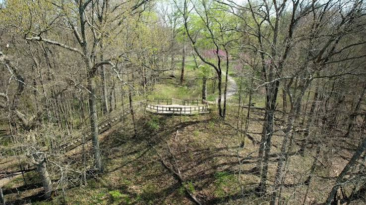
Situated high above the Little Miami River in southwestern Ohio, Fort Ancient is one of the largest prehistoric hilltop earthwork complexes in North America. Originally constructed by the Hopewell culture beginning around 100 BCE, the enclosure stretches across more than 100 acres (40 hectares) and follows the natural contours of a rugged ridge overlooking the surrounding valleys. Although early European settlers mistakenly believed the site served as a military fortress, archaeological research has demonstrated that Fort Ancient functioned primarily as a ceremonial and social center rather than a defensive fortification.

Construction and Layout

The earthworks extend for nearly 5 kilometers (approximately 3.5 miles), enclosing the hilltop with massive earthen walls interrupted by numerous gateways. Rather than forming a continuous defensive barrier, the walls follow the landscape's irregular shape, incorporating steep cliffs and natural ravines into the site's overall design.

Hopewell builders excavated nearby soil using wooden digging tools, stone hoes, and woven baskets before carefully compacting each layer to produce stable embankments. The enormous labor investment required coordinated efforts by large communities over many years, reflecting the strong social organization of Hopewell society.

Ceremonial Landscape

Within the enclosure, archaeologists have discovered evidence of ceremonial plazas, ritual activity, feasting, and craft production rather than permanent domestic neighborhoods. The site's elevated position provided sweeping views across the surrounding river valleys, reinforcing its importance as a sacred gathering place visible from great distances.

Numerous gateways may have guided ritual processions into different sections of the enclosure, while certain alignments correspond with solar events, suggesting that astronomical observations formed part of the site's ceremonial calendar.

Centuries later, the Fort Ancient culture (1000–1650 CE) occupied portions of the area, giving the site its modern name, although they were not the original builders of the monumental earthworks.

Archaeological Significance

Fort Ancient illustrates the Hopewell ability to combine natural topography with monumental architecture, creating sacred spaces that emphasized both landscape and geometry. Ongoing archaeological investigations continue to reveal new insights into Hopewell ceremonial life, social organization, and engineering techniques.

Conclusion

Fort Ancient remains one of prehistoric America's most impressive ceremonial landscapes. Its extensive hilltop earthworks, remarkable engineering, and spiritual significance demonstrate the creativity and organizational abilities of the Hopewell culture while preserving one of Ohio's greatest archaeological treasures.

Newark Earthworks: Ohio's Massive Geometric Mounds

August 15, 2026

Introduction

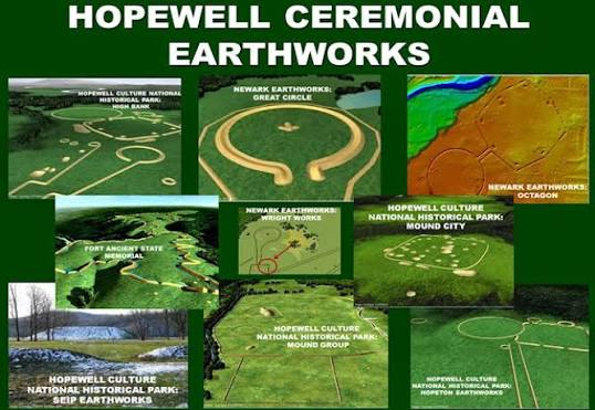
The Newark Earthworks, located in Licking County, Ohio, constitute one of the largest and most sophisticated prehistoric ceremonial landscapes ever constructed anywhere in the world. Built by the Hopewell culture between approximately 100 BCE and 400 CE, the complex originally covered more than 2,000 acres (over 800 hectares) and contained enormous circles, octagons, squares, parallel embankments, and connecting avenues. The scale, precision, and astronomical sophistication of Newark have led archaeologists to recognize it as one of humanity's greatest prehistoric engineering achievements. Today, the site forms part of the UNESCO World Heritage-listed Hopewell Ceremonial Earthworks.

Monumental Engineering

Constructing the Newark Earthworks required the movement of millions of basket-loads of soil using only stone tools, wooden implements, and human labor. Builders created broad earthen walls several meters high while maintaining astonishing geometric accuracy across vast distances.

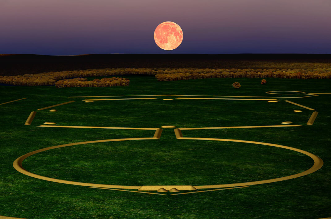
The complex originally included several interconnected components, including the Great Circle, one of North America's largest circular earthworks, and the famous Octagon Earthworks, which remain among the best-preserved Hopewell structures. Long parallel walls linked different sections of the complex, creating an integrated ceremonial landscape unlike any other in prehistoric North America.

Astronomical Observatory

Perhaps the most remarkable aspect of Newark is its role as a sophisticated astronomical observatory. Modern research has demonstrated that the Octagon Earthworks align with the 18.6-year lunar standstill cycle, one of the most complex celestial movements visible to the naked eye. This extraordinary precision indicates generations of systematic sky observation and careful architectural planning.

The earthworks also incorporate alignments related to moonrise, moonset, and seasonal celestial events. Such observations probably governed ceremonial calendars and reinforced religious beliefs concerning the relationship between the heavens and the earth.

Ceremonial Activities

Newark was not a city but a regional ceremonial center visited periodically by communities from across the eastern Woodlands. Pilgrims gathered for religious ceremonies, public feasts, trade fairs, diplomatic meetings, and funerary rituals. The expansive plazas enclosed by the earthworks provided space for large assemblies, while surrounding burial mounds honored important members of Hopewell society.

Excavations have uncovered finely crafted artifacts made from copper from the Great Lakes, marine shells from the Gulf Coast, mica from the Appalachian Mountains, and obsidian from Yellowstone National Park, illustrating one of the most extensive trade networks in prehistoric North America.

Conclusion

The Newark Earthworks stand among the greatest engineering and scientific accomplishments of prehistoric civilization. Their monumental scale, extraordinary geometric precision, sophisticated astronomical alignments, and ceremonial importance demonstrate the remarkable achievements of the Hopewell culture and continue to reshape our understanding of ancient North American societies.

Liberty Earthworks: Ohio's Octagonal Hopewell Site Introduction

August 15, 2026

Introduction

The Liberty Earthworks, situated in Ross County, Ohio, represent another remarkable achievement of the Hopewell culture, dating between 100 BCE and 500 CE. The site forms part of the extensive network of geometric ceremonial earthworks that once covered southern Ohio, showcasing the Hopewell people's extraordinary ability to design large-scale architectural landscapes with mathematical precision. Although portions of the original complex have been lost through agriculture and modern development, archaeological investigations reveal that Liberty Earthworks once served as an important ceremonial center where religious observances, social gatherings, and astronomical observations likely took place.

Architectural Design

The Liberty Earthworks were composed primarily of carefully constructed octagonal and circular embankments connected by straight earthen walls. The octagonal layout demonstrates a sophisticated understanding of geometry, requiring builders to create equal angles and consistent wall lengths over large distances. Earthen embankments were built by excavating nearby soil and transporting it in woven baskets before compacting successive layers to produce stable, durable walls.

The walls maintained relatively uniform heights and widths, indicating careful planning throughout the construction process. Formal gateways connected the different geometric enclosures, creating processional pathways that guided participants during ceremonial events.

Astronomical Knowledge

Many Hopewell earthworks across Ohio display remarkable alignments with celestial events, particularly the movements of the moon. Because Liberty Earthworks share similar geometric characteristics with the Newark Earthworks, archaeologists believe the site may also have been designed to observe important astronomical cycles, including lunar standstills, solstices, and equinoxes.

Such observations would have helped regulate ceremonial calendars, agricultural activities, and seasonal festivals. Rather than serving merely practical purposes, these alignments likely reinforced the Hopewell belief that human communities should remain in harmony with the rhythms of the cosmos.

Community and Religious Functions

The Liberty Earthworks were not defensive structures but ceremonial gathering places that brought together populations from multiple villages scattered throughout the Scioto River Valley. Pilgrims likely traveled considerable distances to participate in rituals, exchange prestige goods, renew alliances, and honor their ancestors.

Ceremonial feasting probably accompanied these gatherings, while skilled artisans displayed elaborate objects crafted from copper, mica, marine shell, obsidian, and finely carved stone. Such events strengthened both social relationships and regional trade networks extending across much of eastern North America.

Conclusion

The Liberty Earthworks highlight the remarkable engineering, astronomical knowledge, and ceremonial traditions of the Hopewell culture. Through precise geometric planning and coordinated communal labor, Hopewell builders created monumental sacred landscapes that reflected both scientific observation and profound spiritual beliefs.

Shriver Circle: Ohio's Hopewell Ditch Enclosure

August 15, 2026

Introduction

Located in Ross County, Ohio, Shriver Circle is one of the many ceremonial earthworks constructed by the Hopewell culture between approximately 100 BCE and 500 CE. Although it is less well known than the nearby Newark or Hopewell Mound Group, Shriver Circle demonstrates the remarkable engineering, surveying, and ceremonial traditions that characterized Hopewell society. Rather than serving as a permanent settlement or military fortification, the enclosure functioned primarily as a sacred gathering place where religious ceremonies, seasonal celebrations, social meetings, and long-distance exchanges took place. The site's carefully planned circular design reflects the Hopewell belief that geometry and landscape held deep spiritual meaning.

Construction and Engineering

Shriver Circle was built as a nearly perfect circular enclosure consisting of a broad earthen embankment surrounded by an exterior ditch. The circular wall measured several hundred feet across and required the excavation and movement of thousands of cubic meters of soil. Hopewell workers accomplished this enormous task using simple stone hoes, antler picks, wooden digging sticks, and woven baskets, demonstrating an impressive level of labor organization despite the absence of metal tools or draft animals.

The builders carefully selected level ground before marking the circle with extraordinary geometric precision. Archaeologists believe that ropes, wooden stakes, and repeated measurements were used to maintain the enclosure's nearly perfect symmetry. The embankment was constructed by layering compacted soil, while the surrounding ditch provided both construction material and additional visual definition. Multiple entranceways interrupted the circular wall, creating formal access points that may have aligned with important landscape features or astronomical events.

Ceremonial and Social Functions

Unlike later Native American towns, Shriver Circle contains little evidence of permanent domestic occupation. Instead, archaeologists believe it functioned as a ceremonial center where dispersed Hopewell communities periodically gathered for religious rituals, feasting, trade, and political alliances. Large open spaces within the enclosure could accommodate hundreds of participants during seasonal festivals.

Artifacts discovered in the surrounding region—including finely crafted stone pipes, ceremonial blades, copper ornaments, mica sheets from the Appalachian Mountains, marine shells from the Gulf Coast, and obsidian imported from Yellowstone—demonstrate that Hopewell communities participated in one of prehistoric North America's largest long-distance exchange networks. These valuable goods were likely displayed, exchanged, or ritually deposited during important ceremonies held at sites such as Shriver Circle.

Archaeological Importance

Shriver Circle contributes to a broader understanding of Hopewell ceremonial landscapes throughout Ohio. Rather than constructing isolated monuments, Hopewell engineers created interconnected ritual centers that combined earthworks, burial mounds, plazas, and processional routes into carefully planned sacred environments. The site's geometric precision also illustrates the sophisticated mathematical knowledge possessed by Hopewell surveyors, who consistently produced remarkably accurate circular enclosures without written measurements or advanced instruments.

Conclusion

Although less famous than Ohio's larger Hopewell monuments, Shriver Circle stands as an impressive example of prehistoric engineering, communal organization, and ceremonial architecture. Its carefully constructed circular enclosure reflects the Hopewell people's advanced surveying abilities, extensive trade connections, and deep spiritual relationship with geometry and the surrounding landscape.

Kents Cavern: England's 400,000-Year Occupation

August 15, 2026

Kents Cavern in Devon is one of Britain's most important prehistoric sites.

Its significance comes from the extraordinary range of evidence preserved within and around the cave system.

Archaeological investigations have revealed traces associated with ancient stone-tool makers, Neanderthal populations, Ice Age animals, and early modern humans.

The story stretches across hundreds of thousands of years.

However, there is an important clarification.

Kents Cavern was not continuously occupied for 400,000 years.

Instead, different populations visited and used the cave and surrounding landscape at different times.

The archaeological deposits represent repeated episodes separated by immense periods of environmental change.

Britain During the Pleistocene

To understand Kents Cavern, modern Britain must be forgotten.

The country we know today did not exist in the same geographical form during much of the Pleistocene.

Sea levels repeatedly changed.

During some periods, Britain was connected to continental Europe.

Animals and human populations could move into the region.

During severe cold phases, large areas became inhospitable.

Human occupation was therefore intermittent.

Kents Cavern preserves evidence from several of these ancient worlds.

The Oldest Toolmakers

The site contains stone tools associated with very ancient periods of human activity.

Handaxes and other implements demonstrate that human populations were present in the region hundreds of thousands of years ago.

These early toolmakers belonged to populations that existed long before modern humans entered Europe.

Their technology demonstrates planning and skill.

A handaxe was created by repeatedly striking stone to produce a symmetrical, sharp-edged object.

The maker had to understand the structure of the stone and anticipate the effects of each blow.

The Neanderthal Chapter

Later archaeological material is associated with Middle Paleolithic populations, including Neanderthals.

Neanderthals repeatedly occupied parts of Britain during favorable climatic periods.

They were capable hunters and skilled toolmakers.

They adapted to changing environments and used sophisticated stone technologies.

At Kents Cavern, their archaeological presence demonstrates that the cave remained part of a human landscape long after the earliest handaxe makers disappeared.

The Arrival of Modern Humans

One of the site's most important discoveries is the fragmentary human upper jaw known as Kents Cavern 4.

The fossil has been identified as belonging to Homo sapiens.

Its chronology has been the subject of significant scientific discussion because directly dating the fossil was not straightforward.

Researchers therefore examined associated materials and the archaeological context.

The result is a continuing debate about exactly when early modern humans reached the region.

What remains clear is that Kents Cavern is central to discussions about the earliest Homo sapiens in Britain and northwestern Europe.

Humans and Carnivores Shared the Cave

Kents Cavern was not exclusively used by humans.

Carnivores also occupied or visited cave systems.

Animal remains can reveal evidence of:

  • Hyenas

  • Bears

  • Deer

  • Horses

  • Woolly rhinoceroses

  • Other Ice Age species

Archaeologists must determine how these bones entered the cave.

A bone may have been brought by a human.

It may have been dragged in by a predator.

It may have been deposited naturally.

Cut marks and tooth marks provide crucial clues.

Why Caves Are Archaeological Time Capsules

A cave can preserve material that would disappear in an open landscape.

Sediment can cover bones and tools.

The stable environment may slow some destructive processes.

However, caves are also complicated.

Water can move deposits.

Animals can disturb sediments.

Later human activity can mix layers.

The interpretation of Kents Cavern therefore depends on detailed geological and archaeological study.

More Than a Prehistoric Home

The people who used Kents Cavern did not simply “live in a cave” in the popular sense.

The cave was one location within a wider landscape.

Humans hunted outside.

They gathered raw materials.

They followed animals.

They moved according to season and climate.

The cave could serve as shelter, a temporary camp, or another specialized location.

The Long Archaeological Record

The true importance of Kents Cavern lies in its chronological range.

Few sites connect so many chapters of Britain's prehistoric past.

Its evidence links:

  • Early Pleistocene or Middle Pleistocene toolmakers

  • Neanderthal-associated populations

  • Early modern humans

  • Later prehistoric communities

The cave therefore demonstrates that Britain's human history is far older than written records.

Long before Roman roads, medieval castles, or even agriculture, humans were already entering the limestone landscape of Devon.

Kents Cavern remains one of the places where that immense history can still be traced.

Sirgenstein Cave: Germany's Paleolithic Layers

August 15, 2026

Some archaeological sites become famous because they contain a spectacular object.

Sirgenstein Cave is important for a different reason.

Its greatest treasure is time.

Within its sediments, archaeologists identified evidence representing multiple chapters of European prehistory. The cave's layers preserve a sequence associated with different technological traditions and human populations, including Middle Paleolithic occupations connected with Neanderthals and Upper Paleolithic phases associated with modern humans.

Sirgenstein is therefore a prehistoric archive.

Its floor became a record book written in sediment, stone, bone, ash, and abandoned tools.

The Importance of Archaeological Layers

The study of Sirgenstein begins with stratigraphy.

Stratigraphy is the analysis of layers.

Over time, sediments accumulate.

A human group may occupy a cave and leave behind stone tools and animal bones.

Later, windblown sediment covers those remains.

Thousands of years pass.

Another group enters the cave and leaves its own material.

Gradually, a sequence develops.

When archaeologists excavate carefully, they can reconstruct that sequence.

In ideal conditions, lower layers are older than higher ones.

However, archaeology is rarely perfectly simple.

Animals can disturb sediments.

Water can move objects.

Human activity can mix layers.

Later excavations may damage earlier deposits.

For this reason, stratigraphic interpretation requires careful analysis.

Sirgenstein became important because it offered an opportunity to study cultural change through a long sequence rather than a single occupation.

The Middle Paleolithic World

The older portions of Sirgenstein's archaeological sequence are associated with the Middle Paleolithic.

Across much of Europe, this period is strongly associated with Neanderthal populations.

Neanderthals were not primitive failures of evolution.

They were successful humans who survived for hundreds of thousands of years across diverse environments.

They hunted.

They controlled fire.

They manufactured sophisticated stone tools.

They adapted to climatic fluctuations.

The tools associated with Middle Paleolithic occupations often demonstrate deliberate preparation and controlled flaking.

A stone was not simply broken randomly.

Craftspeople understood how to select raw material and strike it in ways that produced useful cutting edges.

Neanderthals and the Cave

The Neanderthal-associated inhabitants of Sirgenstein would not have lived entirely inside the cave.

The surrounding landscape was essential.

They moved through valleys.

They located stone resources.

They hunted animals.

They collected fuel.

They may have returned to familiar locations repeatedly.

The cave was one part of a larger territory.

Yet the protected environment of the cave preserved traces of those activities.

Broken tools became archaeological evidence.

Discarded animal bones became evidence of diet and environment.

Hearth-related materials preserved traces of fire.

The Transition to the Upper Paleolithic

One of the greatest questions in European archaeology concerns what happened when Homo sapiens populations entered territories already inhabited by Neanderthals.

The transition was complex.

Different regions experienced it differently.

Some archaeological traditions may represent periods of technological experimentation or population interaction.

Eventually, Neanderthals disappeared as a distinct human population.

Modern humans became the only surviving human species in Europe.

Sirgenstein is important because its sequence contributes to the archaeological study of this broader transition.

The Aurignacian and Modern Humans

Upper layers associated with the Aurignacian represent a cultural world connected with early Homo sapiens.

Compared with earlier periods, Upper Paleolithic archaeology often contains increasing evidence for specialized technologies and symbolic material culture.

In the wider Swabian Jura, Aurignacian communities produced:

  • Mammoth ivory figurines

  • Personal ornaments

  • Bone and antler tools

  • Musical instruments

Sirgenstein forms part of this broader regional context.

The cave therefore connects the Neanderthal world with the cultural world of early modern humans.

Why the Sequence Matters

Imagine finding a single Neanderthal tool.

It tells archaeologists that Neanderthals were present.

Now imagine finding multiple layers.

The lower layer contains one technological tradition.

A higher layer contains another.

Changes become visible.

Researchers can investigate:

  • Changes in stone-tool production

  • Shifts in animal exploitation

  • Environmental change

  • New raw materials

  • Changes in human occupation

The sequence becomes more valuable than any individual artifact.

Sirgenstein is important because it provides this chronological perspective.

Climate Change and Human Occupation

The Paleolithic was shaped by repeated climatic change.

Glaciers advanced and retreated.

Vegetation changed.

Animal populations moved.

Regions became accessible or inhospitable.

Human groups had to adapt.

A cave might be occupied during one climatic phase and abandoned during another.

Therefore, gaps in the archaeological sequence are also important.

The absence of human material can reveal periods when a region was unsuitable or simply not used.

Animal Bones as Environmental Evidence

The faunal remains recovered from cave sites can help reconstruct ancient environments.

Different animals prefer different habitats.

The presence of reindeer, for example, may indicate environmental conditions different from those associated with forest-adapted species.

Bones can also reveal:

  • Butchery marks

  • Carnivore damage

  • Burning

  • Age of hunted animals

  • Seasonality

  • Patterns of resource use

Sirgenstein's deposits therefore contain information about both humans and the ecosystems surrounding them.

A History of Archaeological Research

Like many famous European caves, Sirgenstein was excavated during periods when archaeology was still developing as a scientific discipline.

Early researchers made important discoveries but did not possess modern technologies such as:

  • High-precision radiocarbon dating

  • Ancient DNA analysis

  • Microscopic use-wear analysis

  • Advanced sediment studies

  • Three-dimensional digital recording

This means that archaeological collections can continue to produce new knowledge long after excavation.

A stone tool recovered more than a century ago can be reanalyzed today.

Its microscopic surface may reveal how it was used.

Its raw material may reveal where it came from.

Its archaeological context can be reconsidered using new chronological models.

Sirgenstein as a Prehistoric Archive

The cave demonstrates that human history is not a straight line.

Different populations entered the landscape.

Technologies changed.

Climates shifted.

Species disappeared.

New cultural traditions emerged.

The archaeological layers preserve fragments of these transformations.

Sirgenstein may not contain one object as famous as the Venus of Hohle Fels or the mammoth carvings of Vogelherd.

But its importance is arguably more chronological.

It allows archaeologists to examine change itself.

And sometimes, that is archaeology's greatest achievement.

A single artifact can reveal a moment.

A sequence of layers can reveal a history.

Vogelherd Cave: Germany's 40,000-Year Mammoth Carvings

August 15, 2026

Vogelherd Cave in southwestern Germany has produced some of the most astonishing examples of Ice Age art ever discovered. Among its famous finds are delicately carved animal figurines, including mammoths, horses, cave lions, and other creatures that inhabited the Paleolithic landscape.

These objects are small enough to fit in a human hand, yet their historical significance is enormous.

Some date to roughly 40,000 years ago, placing them among the earliest known examples of figurative art. They demonstrate that early modern humans in Europe were not merely capable of producing abstract marks. They could observe animals closely, transform ivory into recognizable forms, and create portable works of art with no obvious practical purpose.

The Cave of Birds

Vogelherd Cave is located in the Lone Valley of the Swabian Jura in Baden-Württemberg, Germany. The region is internationally renowned for its Paleolithic caves and their exceptional archaeological record.

The cave was discovered and excavated in the twentieth century, and later archaeological work recovered additional material from sediments associated with earlier excavations.

Vogelherd became particularly famous because of its small ivory sculptures.

The cave's archaeological deposits belong primarily to the Upper Paleolithic and include evidence connected with the Aurignacian, a period associated with some of the earliest Homo sapiens populations in Europe.

A Landscape Filled With Ice Age Animals

To understand Vogelherd’s art, it is necessary to imagine the world in which its creators lived.

Upper Paleolithic Europe was home to animals that are now extinct or no longer found in the region. These included mammoths, woolly rhinoceroses, cave lions, reindeer, wild horses, and other species adapted to Ice Age environments.

These animals were not distant symbols. They were part of everyday survival.

Some were hunted.

Others were dangerous competitors or predators.

Their movements shaped hunting strategies, seasonal travel, and human knowledge of the landscape.

It is therefore unsurprising that animals became central subjects of Paleolithic art.

What is remarkable is the technical sophistication with which the artists represented them.

The Famous Mammoth Figurines

The mammoth carvings from Vogelherd are among the site's most celebrated artifacts.

Mammoth ivory was a valuable but challenging material. A craftsperson had to obtain the material, select an appropriate piece, and gradually shape it through cutting, scraping, carving, and polishing.

The final sculptures are not random pieces of modified ivory.

They contain recognizable anatomical features.

Even at a small scale, the artists were able to suggest the distinctive form of the mammoth: its body, head, trunk, and overall proportions.

The creation of such an object required the artist to translate observation into three-dimensional form.

How Were the Figurines Made?

Paleolithic artists did not possess metal tools.

Their technological world was based largely on carefully manufactured stone tools, bone implements, antler, wood, and other available materials.

Flint blades and burins could be used to cut and engrave surfaces. Repeated scraping and carving gradually transformed raw ivory into an animal figure.

The process was slow.

A mistake could damage valuable material.

This means that each figurine represents a significant investment of labor.

The maker also needed a mental image of the desired object before it was complete.

Three-dimensional carving therefore required planning.

Portable Art and the Birth of Figurative Representation

The Vogelherd figurines are examples of portable art, meaning artistic objects small enough to be carried from one location to another.

Portable art differs from cave paintings fixed to walls and ceilings.

An ivory figurine could travel with its owner or community.

It could potentially be displayed, exchanged, carried during seasonal movements, or used in social or ritual contexts.

Because we cannot observe the original cultural setting directly, the exact purpose of each figurine remains uncertain.

They may have represented:

  • Animals of economic importance

  • Spiritual beings

  • Clan identities

  • Mythological narratives

  • Personal objects

  • Symbols of status

  • Ritual items

  • Artistic expression without a single practical function

The safest conclusion is that the objects possessed meaning—but archaeology cannot always recover that meaning completely.

Why the Vogelherd Animals Matter

The figurines demonstrate sophisticated visual cognition.

To create a recognizable animal, an artist must identify the features that distinguish one species from another.

A mammoth must look different from a horse.

A lion must look different from a bison.

The artist therefore selected visual characteristics that could communicate identity even at a miniature scale.

This suggests an ability to categorize, remember, and manipulate mental representations of the natural world.

The Aurignacian Artistic Explosion

Vogelherd is part of a broader pattern of early Upper Paleolithic symbolic production.

Across parts of Europe, archaeologists have discovered ornaments, engravings, paintings, carvings, and musical instruments associated with early modern human populations.

The Swabian Jura is especially important because of the age and concentration of its discoveries.

The region has produced:

  • Ivory animal figures

  • Human and animal composite figures

  • Musical instruments

  • Personal ornaments

  • Other examples of symbolic material culture

Together, these discoveries demonstrate that the early Upper Paleolithic was a period of remarkable cultural innovation.

Were These the First Works of Art?

The answer depends on what is meant by “art.”

Humans were creating pigments, engravings, symbolic markings, and decorative objects long before the Aurignacian.

Other species, including Neanderthals, may also have engaged in symbolic behavior.

Therefore, it would be inaccurate to claim that Vogelherd represents the absolute beginning of artistic thought.

Its importance lies elsewhere.

The figurines are among the earliest surviving examples of clearly recognizable three-dimensional figurative art produced on an extraordinary level of craftsmanship.

Excavation and Rediscovery

The archaeological history of Vogelherd is also important.

Early excavations recovered famous sculptures, but later research demonstrated that archaeological sites can continue to produce new information long after their initial discovery.

Re-examination of excavated sediments and renewed archaeological work recovered additional artifacts and fragments.

This illustrates a fundamental principle of archaeology: excavation does not simply “find objects.” Methods improve, questions change, and material once overlooked can become scientifically valuable.

Art in a Dangerous World

There is something striking about the contrast between the beauty of the Vogelherd figurines and the environment in which they were created.

Ice Age Europe could be dangerous.

Human groups had to secure food, survive cold temperatures, navigate changing environments, and coexist with large predators.

Yet within that world, people devoted time to carving tiny representations of animals.

This challenges the assumption that art emerges only after societies become wealthy or technologically advanced.

The makers of the Vogelherd figurines lived as mobile hunter-gatherers.

Their survival depended on intimate knowledge of animals and landscapes.

But they were also capable of creating objects that existed beyond immediate necessity.

The Legacy of Vogelherd Cave

Today, Vogelherd Cave is one of the key sites for understanding the development of symbolic culture in prehistoric Europe.

Its mammoths and other figurines have transformed discussions about the intellectual abilities of early Homo sapiens.

They reveal individuals capable of observation, imagination, planning, craftsmanship, and cultural expression.

A tiny mammoth carved from ivory may not appear powerful at first.

But when archaeologists realize that it was created around forty thousand years ago, its meaning changes.

It becomes evidence of an ancient mind looking at the natural world and deciding that the world was worth recreating in art.

Geißenklösterle: Germany's Aurignacian Flute Cave

August 15, 2026

For most of human history, music leaves almost no archaeological trace. Songs disappear when their performers die, wooden instruments decay, and the rhythms of ancient communities cannot be recovered from stone tools alone. Yet deep within the caves of the Swabian Jura in southwestern Germany, archaeologists discovered something extraordinary: carefully manufactured musical instruments dating to the Upper Paleolithic. At Geißenklösterle Cave, fragments of flutes made from mammoth ivory and bird bone have provided some of the strongest evidence that early modern humans in Europe possessed a sophisticated musical culture tens of thousands of years ago.

The significance of Geißenklösterle extends far beyond the discovery of ancient instruments. The cave preserves evidence of the Aurignacian, an archaeological culture associated with some of the earliest populations of Homo sapiens in Europe. Alongside musical instruments, archaeologists have found stone tools, worked bone and ivory, ornaments, animal remains, and evidence of repeated human activity. Together, these discoveries challenge the outdated image of Ice Age people as individuals concerned only with survival. The inhabitants of the Swabian Jura were hunters and gatherers living in a demanding environment, but they were also artists, craftspeople, symbol-makers, and musicians.

A Cave in the Swabian Jura

Geißenklösterle—often translated as something close to “Goat Monastery”—is located in the Ach Valley of the Swabian Jura, a limestone region of southern Germany famous for its concentration of Paleolithic caves. During the Upper Paleolithic, this landscape offered rock shelters and caves that could be repeatedly used by human groups moving through the region.

The caves of the Swabian Jura have become internationally important because they preserve an exceptional concentration of early figurative art and musical instruments. Geißenklösterle is part of this wider archaeological landscape, which also includes sites such as Hohle Fels and Vogelherd Cave.

Its deposits contain layers associated with different periods of prehistoric occupation. The most famous belong to the Aurignacian, generally associated with the early expansion of anatomically modern humans across Europe during the Upper Paleolithic.

The Aurignacian and the Arrival of Modern Humans

The Aurignacian is one of the earliest Upper Paleolithic archaeological traditions in Europe. It is associated with the period when Homo sapiens populations were expanding across the continent and, in many regions, eventually replacing or absorbing populations of Neanderthals.

Aurignacian communities produced increasingly specialized technologies. Archaeologists identify the period through characteristic stone and bone tools, ornaments, artistic objects, and other cultural remains.

The discoveries at Geißenklösterle are particularly important because they demonstrate that symbolic and artistic behavior was already highly developed during this early phase of modern human occupation in Europe.

The creation of a flute, for example, requires much more than finding a hollow piece of bone. A maker must select suitable material, shape or prepare it, create finger holes in appropriate positions, and produce an instrument capable of generating controlled sound. Such work suggests accumulated technical knowledge and cultural transmission.

The Discovery of the Ancient Flutes

Among the most remarkable finds from Geißenklösterle are fragments of musical instruments made from bird bone and mammoth ivory.

Bird bones were particularly suitable for flute production because some are naturally hollow. A long bone from a large bird could be modified by creating finger holes and shaping the instrument.

Mammoth ivory presented a much greater technical challenge.

Unlike a bird bone, a mammoth tusk is solid. To create a hollow instrument, Ice Age craftspeople had to split, shape, hollow, and join pieces of ivory. This required planning and technical expertise. The resulting object was not accidental—it represented a deliberately engineered instrument.

The existence of multiple instruments or instrument fragments strongly suggests that music was not an isolated experiment performed by a single individual. It was more likely part of a broader cultural tradition.

How Old Are the Instruments?

Dating Paleolithic sites is complicated. Archaeologists rely on methods such as radiocarbon dating and careful analysis of stratigraphic layers—the sequence of deposits in which artifacts are found.

The Geißenklösterle instruments have been the subject of significant scholarly discussion because of their great age and the difficulties involved in dating materials near the limits of radiocarbon analysis.

The instruments are generally associated with the early Upper Paleolithic and are often dated to approximately 40,000 years ago or more, depending on the dating method and chronological framework being used.

The precise ranking of the world’s “oldest flute” can change as new discoveries are analyzed, but Geißenklösterle remains among the most important sites for the study of humanity’s earliest known musical instruments.

What Did the Music Sound Like?

This is where archaeology encounters an unavoidable limitation.

The original melodies played inside Geißenklösterle are lost.

No written musical notation survives from the Upper Paleolithic, and even if a flute can be reconstructed, modern researchers cannot know exactly what scales, rhythms, or musical traditions ancient people used.

However, experimental archaeology can help answer some questions.

Researchers can reconstruct instruments based on archaeological dimensions and test the sounds they are capable of producing. Such experiments demonstrate that the flutes were functional musical instruments rather than symbolic objects resembling instruments.

This does not mean that a reconstructed performance reproduces Ice Age music exactly. Instead, it shows the acoustic possibilities available to the original makers.

Why Would Ice Age People Make Music?

Music may have served many purposes.

It could have accompanied:

  • Rituals and ceremonies

  • Storytelling

  • Group gatherings

  • Dance

  • Social bonding

  • Courtship

  • Mourning

  • Seasonal celebrations

  • Teaching and cultural transmission

Music can also create emotional coordination among groups. Modern humans use rhythm and shared performance to reinforce identity and cooperation, and it is possible that prehistoric communities benefited from similar social effects.

The archaeological evidence cannot tell us exactly why a particular flute was played. But the effort invested in creating these instruments demonstrates that sound and performance mattered enough to justify valuable time and materials.

Music, Art, and the Ice Age Mind

The Swabian Jura is famous not only for music but also for some of the earliest known figurative artworks.

This combination is significant.

A society capable of carving animals and human-like figures from ivory, manufacturing ornaments, and creating musical instruments possessed a complex symbolic culture. These activities required imagination, memory, manual skill, and the ability to transmit knowledge.

The Ice Age inhabitants of the region were therefore not simply adapting biologically to a harsh environment. They were creating shared worlds of images, sounds, symbols, and traditions.

The Cave’s Wider Importance

Geißenklösterle demonstrates why caves are such important archaeological archives.

Over thousands of years, human activity can accumulate in layers. A cave floor may preserve discarded tools, food remains, fragments of ornaments, hearth-related material, and broken objects that would otherwise disappear.

By excavating these layers carefully, archaeologists can reconstruct changing patterns of occupation.

The cave also provides evidence relevant to one of prehistory’s largest questions: what happened when modern humans entered Europe?

Sites such as Geißenklösterle show that some of the earliest Upper Paleolithic Homo sapiens communities brought with them—or rapidly developed—complex technological and symbolic traditions.

Why Geißenklösterle Changed the History of Music

For centuries, prehistoric people were often portrayed as intellectually primitive. Artistic and musical achievements were assumed to belong to much later civilizations.

The discoveries from Geißenklösterle helped destroy that assumption.

By approximately forty millennia ago, humans in southern Germany were producing objects requiring advanced craftsmanship and engaging in activities that cannot be explained simply as immediate survival.

A flute does not kill an animal, build a shelter, or directly protect its owner from winter.

Yet someone made one.

Someone understood how it worked.

Someone probably taught others.

And someone, standing in or near an Ice Age cave, once transformed breath into organized sound.

That is why Geißenklösterle remains one of the most extraordinary archaeological sites in Europe. It preserves evidence not only of ancient people but of one of humanity’s oldest surviving conversations with music.

Noisetier Cave: France's Gravettian Venus Figurines

August 10, 2026

Noisetier Cave, or Grotte du Noisetier, is a prehistoric cave site in the Aure Valley of the French Pyrenees that contributes important evidence to the study of Neanderthal lifeways, Middle Paleolithic technology, animal exploitation, and the behavior of human groups living in mountainous environments. Its archaeological significance, however, requires an important clarification. Despite the title used here, Noisetier Cave is not established as a Gravettian site containing the famous type of Upper Paleolithic "Venus" figurines. The principal archaeological record from the cave is associated with the Middle Paleolithic and Mousterian traditions, generally attributed to Neanderthals.

This distinction is important because the Gravettian is a much later Upper Paleolithic cultural tradition, generally associated with anatomically modern humans in Europe and famous for its female figurines, ivory objects, ornaments, and distinctive lithic technologies. Noisetier Cave instead belongs primarily to a much earlier archaeological world in which Neanderthal groups exploited mountain environments, processed animal carcasses, manufactured stone tools, and used caves as temporary occupation and activity locations.

The site is nevertheless extremely valuable because it helps reconstruct a part of European prehistory that is sometimes overshadowed by spectacular Upper Paleolithic art.

The Location of Noisetier Cave

Noisetier Cave is located in the Aure Valley of the Hautes-Pyrénées, in southwestern France. The cave is situated within a limestone landscape characteristic of the Pyrenean region.

Its popular French name, Grotte du Noisetier, refers to the hazel trees growing near its entrance.

The cave itself is relatively small compared with famous decorated caves such as Chauvet or Lascaux. Its archaeological importance does not come from monumental paintings but from the quantity and variety of evidence preserved within its deposits.

Excavations and investigations have documented Mousterian lithic material together with substantial faunal remains.

A Neanderthal Rather Than Gravettian Site

The chronological distinction is essential.

The Mousterian is broadly associated with Neanderthals across much of Europe during the Middle Paleolithic.

The Gravettian, by contrast, belongs to the later Upper Paleolithic.

These traditions differ in chronology, technology, subsistence patterns, and archaeological context.

Noisetier Cave's principal evidence belongs to the Mousterian tradition.

Consequently, it would be inaccurate to describe its archaeological record as a collection of Gravettian Venus figurines.

The famous European "Venus" figurines are instead associated with Upper Paleolithic contexts at sites such as Willendorf, Dolní Věstonice, Lespugue, Laussel, and Brassempouy.

The distinction is not merely terminological. It changes our interpretation of the people who occupied the cave.

What Archaeologists Found

The archaeological deposits of Noisetier Cave contain numerous stone artifacts and animal remains.

The faunal assemblage is particularly important.

More than 10,000 large-animal fossil remains and tens of thousands of identifiable small-rodent remains have been reported from the site. Mountain-adapted animals such as chamois and ibex are prominent, while deer and large bovines are also represented.

These remains allow archaeologists to investigate several questions:

  • What animals were hunted?

  • Which parts of carcasses were transported?

  • How were animals butchered?

  • How were bones processed?

  • Did carnivores later modify the remains?

  • What seasons might the cave have been occupied?

  • How did Neanderthals exploit mountainous environments?

Neanderthal Hunting and Butchery

Cut marks on animal bones provide evidence for human processing.

When stone tools are used to remove flesh, tendons, or other tissues, microscopic marks can remain on the bone.

These marks can be studied through taphonomic analysis, which examines what happened to archaeological remains between the death of an animal and their discovery by archaeologists.

At Noisetier Cave, human activity appears to have played a major role in the accumulation and modification of some animal remains, particularly deer and bovines.

This contributes to a broader picture of Neanderthal subsistence.

Neanderthals were not simply opportunistic scavengers wandering through Europe.

They were capable hunters who could exploit difficult environments and transport, butcher, and process animal resources.

The Mountain Environment

The Pyrenean setting is particularly significant.

Mountain environments present both opportunities and challenges.

Animals such as ibex and chamois are well adapted to steep terrain.

Successfully hunting them requires knowledge of:

  • seasonal movements,

  • feeding areas,

  • migration routes,

  • cliffs and slopes,

  • weather conditions,

  • and animal behavior.

The presence of mountain fauna at Noisetier therefore tells us something about the ecological knowledge of the site's inhabitants.

Neanderthals were capable of living in landscapes that demanded detailed environmental familiarity.

Stone Tools

The stone tools from Noisetier belong primarily to the Mousterian technological tradition.

Mousterian assemblages commonly include tools such as scrapers and other flaked implements.

The production of stone tools required knowledge of raw materials, fracture mechanics, and the intended function of different tool forms.

A tool could be used for:

  • cutting meat,

  • processing hides,

  • working wood,

  • shaping other materials,

  • or other tasks.

The archaeological record therefore represents not simply "stones," but evidence of technical decision-making.

Bone Retouchers

One particularly interesting category of material from Noisetier is bone retouchers.

A bone retoucher is an animal-bone fragment that was used to modify stone tools.

When a stone tool needed reshaping or sharpening, a Neanderthal could strike its edge with a hard piece of bone.

Repeated impacts leave characteristic marks.

The discovery of such evidence is important because it demonstrates a relationship between animal exploitation and stone-tool production.

An animal carcass did not necessarily provide only food.

Its bones could subsequently become tools used to manufacture or maintain other tools.

This illustrates a sophisticated pattern of resource recycling.

What About Venus Figurines?

The title's reference to "Gravettian Venus figurines" deserves particular clarification.

The European Gravettian is indeed famous for numerous female figurines, often referred to collectively as "Venuses." However, the term "Venus" is a modern archaeological label and should not be interpreted as proof that prehistoric people worshipped a goddess equivalent to the Roman Venus.

The meaning of these figurines remains uncertain.

Possible interpretations include:

  • representations of individuals,

  • symbolic female figures,

  • fertility-related imagery,

  • social identities,

  • ancestors,

  • teaching objects,

  • or objects whose meaning varied according to context.

Archaeologists generally avoid assuming a single universal interpretation.

Noisetier Cave should therefore not be used as evidence for Gravettian Venus traditions without additional archaeological evidence.

Why the Correction Matters

Correct chronology is fundamental to prehistoric archaeology.

Imagine placing a medieval castle into the Bronze Age simply because both are located in France.

The geographic association would be true, but the historical interpretation would be completely wrong.

The same principle applies to prehistoric caves.

A cave may contain evidence from several periods, but individual artifacts must be associated with the appropriate archaeological layers.

At Noisetier, the strongest evidence concerns Neanderthal Mousterian occupation and animal exploitation, not Gravettian figurine production.

The Importance of Noisetier Cave

Noisetier's significance therefore lies elsewhere.

It provides evidence for:

  • Neanderthal hunting,

  • mountain adaptation,

  • Mousterian technology,

  • carcass processing,

  • bone-tool production,

  • environmental exploitation,

  • and prehistoric occupation of the Pyrenean region.

It reminds us that prehistoric archaeology is not only about spectacular art.

Much of what archaeologists know about ancient humans comes from apparently ordinary materials: broken bones, stone flakes, damaged tools, hearth residues, and microscopic marks.

These traces allow researchers to reconstruct behavior that occurred tens of thousands of years ago.

Conclusion

Noisetier Cave should not be presented as a confirmed Gravettian Venus-figurine site. Its principal archaeological identity is instead that of a Middle Paleolithic/Mousterian site associated with Neanderthals.

That correction does not diminish its importance.

Quite the opposite.

The cave provides an opportunity to examine how Neanderthals lived in a demanding mountain environment, hunted animals, processed carcasses, produced stone tools, and used animal bones as technological resources.

Its story demonstrates an essential principle of archaeology: the most important discoveries are not always the most visually spectacular.

A small cave filled with fragments of stone and bone can reveal an extraordinary amount about the intelligence, adaptability, and daily lives of people who lived in Europe long before the appearance of the Gravettian artists.

Bruniquel Cave: France's 176,000-Year Neanderthal Rings

August 10, 2026

Deep beneath the limestone landscape of southwestern France lies one of the most extraordinary archaeological discoveries associated with Neanderthals: a series of deliberately constructed circular and semi-circular structures made from broken stalagmites.

These mysterious formations occur deep inside Bruniquel Cave, far beyond the zone that would naturally receive sunlight.

Their age is approximately 176,000 years, placing them in the Middle Pleistocene and long before the widespread appearance of anatomically modern humans in Europe.

The structures therefore provide extraordinary evidence that Neanderthals entered deep cave environments and deliberately modified them.

The discovery challenged older assumptions about Neanderthal capabilities.

Rather than simply occupying the entrances of caves, Neanderthals were capable of traveling deep underground, organizing materials, constructing structures, and apparently using fire in an environment where there was no natural daylight.

The findings were reported in Nature in 2016. Researchers concluded that the annular constructions were anthropogenic because of their regular geometry, arrangement of broken stalagmites, and traces of fire. Uranium-thorium dating placed them at approximately 176,500 years old.

The Discovery of the Cave

Bruniquel Cave is located in southwestern France.

The cave had long been known locally, but its deepest passages were not immediately accessible to modern explorers.

In 1990, speleologists discovered a passage leading far into the cave.

What they encountered was extraordinary.

The passage contained structures that clearly did not resemble ordinary geological formations.

Thousands of fragments of stalagmites had been deliberately broken and arranged into patterns.

The Structures

The most famous features are approximately six structures, including circular and semi-circular arrangements.

They were constructed from pieces of stalagmite, a mineral deposit formed when water containing dissolved minerals drips onto a cave floor.

The builders had broken the stalagmites and transported the fragments.

They then arranged them into carefully organized structures.

The regularity of these formations is crucial.

Natural geological processes can create circles, terraces, and unusual mineral formations.

However, the Bruniquel structures display characteristics consistent with deliberate construction.

The Extraordinary Depth

Perhaps the most remarkable aspect of Bruniquel is not simply the structures themselves.

It is where they were built.

The constructions lie approximately 336 meters from the original entrance.

At such a depth, natural sunlight could not reach them.

This means that the Neanderthals who constructed them had to enter the cave deliberately.

They would have required artificial illumination.

The presence of fire-related evidence makes this especially significant.

Evidence of Fire

Researchers identified traces of burning associated with the structures.

This suggests that fire was used inside the deep cave.

Fire would have served several purposes.

It could provide:

  • illumination,

  • warmth,

  • protection,

  • and perhaps a role in activities carried out at the site.

The requirement for lighting is particularly important.

A person cannot easily transport and arrange hundreds of heavy mineral fragments in total darkness.

The builders therefore had to plan their movement through the cave.

Uranium-Thorium Dating

Dating cave structures can be difficult.

Traditional radiocarbon dating is generally ineffective for materials much older than approximately 50,000 years.

Researchers instead used uranium-thorium dating.

This method is particularly useful for carbonate materials such as stalagmites.

The dating placed the formation of the structures at approximately 176,500 years ago, with an uncertainty range of several thousand years.

This date is extraordinarily significant.

It places the constructions within a period when Neanderthals were the dominant hominin population in western Europe.

Who Built Them?

The original research strongly associated the structures with Neanderthals.

The reason is chronological.

The structures are approximately 176,000 years old.

At this time, Neanderthals were present in Europe, whereas modern humans had not yet established the later widespread European populations associated with the Upper Paleolithic.

The archaeological evidence therefore provides a strong case that the builders were Neanderthals.

What Were the Structures Used For?

This is one of the most difficult questions.

The structures' purpose remains uncertain.

Archaeologists have proposed several possibilities.

They could have been associated with:

  • ritual behavior,

  • social gatherings,

  • symbolic activity,

  • practical activities,

  • controlled fire use,

  • or some combination of these.

It is tempting to call them "ritual structures."

However, archaeology cannot demonstrate ritual intention simply from the presence of a constructed circle.

The responsible conclusion is that the structures demonstrate organized and intentional construction, while their precise function remains unknown.

Why Were Stalagmites Chosen?

The builders did not simply pile random stones.

They used broken stalagmites.

The material was available inside the cave, but choosing and arranging it required deliberate action.

The structures demonstrate several stages of behavior:

  1. selecting material;

  2. breaking stalagmites;

  3. transporting pieces;

  4. arranging them;

  5. maintaining their geometric pattern;

  6. potentially using fire around or near them.

This represents a substantial investment of time and energy.

Neanderthal Cognitive Abilities

Bruniquel is important because it contributes to the debate over Neanderthal cognition.

For much of the history of paleoanthropology, Neanderthals were portrayed as less sophisticated than modern humans.

That view has changed dramatically.

Evidence from different sites demonstrates Neanderthal abilities involving:

  • controlled fire,

  • complex hunting,

  • bone tools,

  • pigments,

  • personal ornaments,

  • burial practices,

  • and spatial organization.

Bruniquel adds another dimension:

deep subterranean construction.

Planning and Cooperation

Constructing the structures required more than individual strength.

The work probably required coordination.

Someone had to identify suitable stalagmites.

Someone had to break or manipulate them.

The fragments had to be moved through difficult terrain.

The structures then had to be assembled according to a pattern.

Even if only a small group participated directly, the activity suggests social coordination.

The Cave as a Different World

The deep cave environment may have had psychological significance.

Entering the cave meant leaving the ordinary world.

The deeper sections would have been:

  • dark,

  • enclosed,

  • acoustically unusual,

  • difficult to navigate,

  • and physically challenging.

The experience would have been dramatically different from ordinary outdoor life.

This does not prove that the structures had religious significance.

But it demonstrates that Neanderthals deliberately entered an environment with no obvious everyday necessity for habitation.

The Meaning of the Rings

The rings are especially important because geometry is involved.

The structures contain repeated circular or semi-circular arrangements.

Geometric organization implies intentionality.

This is different from simply lighting a fire or occupying a natural shelter.

The builders transformed an underground environment.

They created something that did not previously exist.

A Challenge to Old Stereotypes

The discovery fundamentally changed how many researchers and members of the public think about Neanderthals.

The stereotype of Neanderthals as primitive cave-dwellers is inadequate.

Bruniquel demonstrates that at least some Neanderthals:

  • traveled deep underground,

  • manipulated difficult materials,

  • constructed organized structures,

  • used fire underground,

  • and operated in groups.

The cognitive and social implications are considerable.

Conclusion

Bruniquel Cave is one of the most remarkable archaeological sites associated with Neanderthals.

Approximately 176,000 years ago, people entered deep darkness beneath the French landscape and constructed geometric arrangements from broken stalagmites.

We do not yet know exactly why.

That uncertainty is part of what makes the discovery so fascinating.

The evidence does not permit us to invent a specific ritual or belief system.

But it does demonstrate something extraordinary:

Neanderthals were capable of deliberately transforming deep subterranean environments.

The rings at Bruniquel therefore stand as physical evidence of planning, cooperation, technological ability, and behavior far more complex than older stereotypes of Neanderthals allowed.

← Newer Posts Older Posts →
Featured
images (21).jpeg
August 21, 2026
Sangla: Baspa's 17th-Century Kinner Kailash Temple
August 21, 2026
Read more →
August 21, 2026
site_1560_0013-400-400-20180220102226.webp
August 21, 2026
Medina Azahara: The Lost Palace City of the Caliph Who Wanted to Build Paradise
August 21, 2026
Read more →
August 21, 2026
images (23).jpeg
August 21, 2026
Alcazaba de Almeria: Almeria's 10th-Century Fortress
August 21, 2026
Read more →
August 21, 2026
images (24).jpeg
August 21, 2026
Castelo de São Jorge: The Lisbon Citadel Built on Thousands of Years of History
August 21, 2026
Read more →
August 21, 2026
images (25).jpeg
August 21, 2026
Silves Castle: Algarve's Almohad Fortress
August 21, 2026
Read more →
August 21, 2026
images (14).jpeg
August 21, 2026
Triloknath: Lahaul's Indo-Tibetan Temple
August 21, 2026
Read more →
August 21, 2026
read more

Powered by The archaeologist