• MAIN PAGE
  • LATEST NEWS
    • Lost Cities
    • Archaeology's Greatest Finds
    • Underwater Discoveries
    • Greatest Inventions
    • Studies
    • Blog
  • PHILOSOPHY
  • HISTORY
  • RELIGIONS
    • Africa
    • Anatolia
    • Arabian Peninsula
    • Balkan Region
    • China - East Asia
    • Europe
    • Eurasian Steppe
    • Levant
    • Mesopotamia
    • Oceania - SE Asia
    • Pre-Columbian Civilizations of America
    • Iranian Plateau - Central Asia
    • Indus Valley - South Asia
    • Japan
    • The Archaeologist Editor Group
    • Scientific Studies
    • Aegean Prehistory
    • Historical Period
    • Byzantine Middle Ages
    • Predynastic Period
    • Dynastic Period
    • Greco-Roman Egypt
  • Rome
  • PALEONTOLOGY
  • About us
Menu

The Archaeologist

  • MAIN PAGE
  • LATEST NEWS
  • DISCOVERIES
    • Lost Cities
    • Archaeology's Greatest Finds
    • Underwater Discoveries
    • Greatest Inventions
    • Studies
    • Blog
  • PHILOSOPHY
  • HISTORY
  • RELIGIONS
  • World Civilizations
    • Africa
    • Anatolia
    • Arabian Peninsula
    • Balkan Region
    • China - East Asia
    • Europe
    • Eurasian Steppe
    • Levant
    • Mesopotamia
    • Oceania - SE Asia
    • Pre-Columbian Civilizations of America
    • Iranian Plateau - Central Asia
    • Indus Valley - South Asia
    • Japan
    • The Archaeologist Editor Group
    • Scientific Studies
  • GREECE
    • Aegean Prehistory
    • Historical Period
    • Byzantine Middle Ages
  • Egypt
    • Predynastic Period
    • Dynastic Period
    • Greco-Roman Egypt
  • Rome
  • PALEONTOLOGY
  • About us
No results found

Morija Museum Sites: Lesotho's Mission Era

October 4, 2026

Introduction

The history of Lesotho cannot be fully understood without examining the encounter between Basotho society and Christian missions during the nineteenth century and the changes that followed. Mission stations became places of religious instruction, literacy, education, printing, translation, and cultural exchange. They also operated within broader processes of political change, colonial expansion, and the transformation of social institutions.

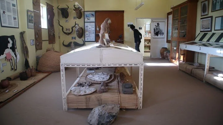
The title Morija Museum Sites: Lesotho's Mission Era focuses attention on Morija and its importance in preserving the history of missionary activity and Basotho cultural life. The Morija Museum and Archives provides an important institutional setting for exploring historical documents, material culture, and the development of written and recorded heritage.

A balanced account must recognize that mission history was not simply a story of European influence. Basotho people made decisions about Christianity, education, literacy, and political relationships, and their responses shaped the character of the mission era.

The Establishment of Morija

Morija became an important center of missionary activity in the nineteenth century. French Protestant missionaries associated with the Paris Evangelical Missionary Society established a presence among Basotho communities during a period of major political and social change.

The establishment of mission stations took place within the wider history of Moshoeshoe I and the development of the Basotho polity. Political leaders faced challenges involving conflict, territorial pressure, diplomacy, and the need to maintain the security of their communities.

Missionaries brought religious teachings and new forms of schooling, but they also depended on relationships with local leaders and communities. Their activities were shaped by the political realities of the region rather than operating separately from them.

The history of Morija should therefore be understood as a process of negotiation, adaptation, and sometimes disagreement between people with different beliefs and objectives.

Christianity and Basotho Society

Christianity introduced new religious ideas and institutions, but its adoption varied among individuals, families, and communities. Some Basotho embraced Christian teaching, while others maintained established religious practices or combined different forms of belief and social participation.

Conversion could affect family relationships, marriage practices, education, and ideas about authority. Missionaries sometimes criticized local customs that they regarded as inconsistent with Christian teaching. Such criticism could create tensions, particularly when religious instruction challenged established social responsibilities or cultural practices.

At the same time, Basotho Christians were not merely passive recipients of foreign beliefs. They interpreted religious teachings through their own experiences and helped shape the development of Christian communities in Lesotho.

A historical account should therefore consider both the influence of missionaries and the agency of Basotho individuals who accepted, adapted, debated, or rejected their teachings.

Literacy, Language, and Printing

One of the most lasting aspects of mission activity was the development of literacy and written materials. Mission schools taught reading and writing, often using religious texts as central educational resources. The translation and printing of Christian materials also contributed to the development of written Sesotho.

Written language can have consequences beyond religious instruction. It supports correspondence, record keeping, the production of educational materials, and the preservation of historical accounts. It can also help standardize spelling and written forms, although language continues to change through everyday use.

Printing and literacy created new opportunities for Basotho writers, educators, religious leaders, and intellectuals. They also influenced how history was recorded and whose perspectives were preserved in written form.

Missionary archives must nevertheless be read critically. Documents written by missionaries may contain valuable observations, but they often reflect the assumptions and priorities of their authors. Basotho perspectives may be underrepresented or appear only through the words of European observers.

Education and Social Change

Mission schools became important centers of formal education. They provided instruction in literacy and religious studies and, in some cases, other subjects that prepared students for new roles in churches, administration, teaching, and public life.

Education could create opportunities for social mobility, but access was not equal. It depended on location, family circumstances, gender expectations, economic resources, and the availability of schools.

The relationship between mission education and traditional knowledge was complex. Schooling could introduce new skills while also encouraging students to question certain customary practices. In other circumstances, educated Basotho used literacy to strengthen local institutions, preserve cultural knowledge, and participate more effectively in political debate.

It would be misleading to describe education as either entirely beneficial or entirely destructive. Its effects varied according to the institutions involved and the ways individuals used the opportunities available to them.

Morija as a Center of Cultural Preservation

Morija's historical importance extends beyond the mission station itself. The area's cultural institutions preserve materials that can help researchers examine the development of Basotho society, including documents, photographs, objects, and other historical records.

Museums and archives provide a link between physical evidence and public understanding. They can help visitors investigate how communities experienced political change, education, religious transformation, and the growth of modern institutions.

Collections must be interpreted carefully. An object removed from its original setting may lose some of its meaning unless its history, ownership, use, and cultural significance are documented. Archival descriptions may also reflect older assumptions that require reassessment.

Collaboration with Basotho historians, cultural practitioners, families, and community organizations can help create interpretations that include a wider range of perspectives.

Mission History and Colonial Power

Missionary activity took place within a period of growing European influence in Southern Africa. Although religious organizations and colonial governments were not identical institutions, their activities could overlap in education, language, administration, and ideas about social reform.

Missionaries sometimes criticized colonial abuses or supported Basotho interests, while at other times missionary attitudes reinforced European cultural hierarchies. The relationship between religion and political power was therefore complicated.

A careful historical account should avoid treating all missionaries as identical or assuming that all Basotho responded in the same way. The historical record contains cooperation, disagreement, adaptation, and resistance.

Preserving the Mission-Era Heritage

Buildings, archival documents, photographs, and personal histories associated with the mission era require long-term care. Paper materials are vulnerable to moisture, insects, light, and physical handling, while historic buildings can deteriorate through weathering and inadequate maintenance.

Digitization can improve access to fragile documents, although digital copies do not replace the need to preserve original materials. Conservation plans should also consider community access, ownership, privacy, and the appropriate treatment of sensitive historical information.

Conclusion

Morija's museum and historical sites provide an important setting for examining the mission era in Lesotho. The period brought changes in religion, education, literacy, and cultural institutions, but these changes were shaped by Basotho decisions and the political realities of the region.

By combining archival research, material culture, oral history, and critical historical analysis, researchers can develop a more complete account of Morija's significance. Its heritage reveals not only the arrival of missionary institutions but also the ways Basotho communities interpreted new ideas, defended their interests, and helped shape the society that emerged.
Roma Valley: Lesotho's Neolithic Finds

October 4, 2026

Introduction

The study of early human communities often depends on small and easily overlooked objects: stone flakes, fragments of bone, charcoal, pottery, and traces of ancient occupation. These materials can reveal how people obtained food, made tools, used landscapes, and adapted to changing environments.

The title Roma Valley: Lesotho's Neolithic Finds raises questions about the earliest archaeological evidence associated with the valley and the cultural changes that occurred over time. However, the term “Neolithic” must be used carefully in Southern African archaeology. It is a classification developed largely from archaeological sequences in other parts of the world and does not always correspond neatly to the timing or character of technological change in Lesotho.

A responsible interpretation of Roma Valley's early finds therefore requires verified archaeological evidence and a clear explanation of the terminology being used.

Understanding the Neolithic Concept

In many regions, the Neolithic is associated with changes such as the development of farming, animal domestication, pottery production, and more settled ways of life. These developments did not occur everywhere simultaneously, nor did they always appear together.

Southern Africa has its own complex archaeological chronology. Communities used stone tools for long periods, and different populations adopted livestock keeping, cultivation, pottery, and ironworking at different times. Some communities combined food production with hunting and gathering rather than abandoning earlier subsistence practices.

For this reason, researchers must avoid assuming that a stone tool automatically belongs to a Neolithic period or that the presence of pottery proves the existence of farming. Archaeological classifications need to reflect the evidence and history of the region being studied.

The Importance of Roma Valley's Landscape

The physical environment of Roma Valley can provide a starting point for understanding why people may have used the area. Valleys can offer access to water, relatively level ground, routes through the landscape, and nearby resources. Surrounding slopes and uplands may provide additional opportunities for gathering plants, hunting animals, or keeping livestock in later periods.

Yet the usefulness of a valley changes according to season and historical conditions. Water availability, vegetation, soil quality, and the presence of animals may vary over time. A location that is productive today may have supported different resources in the past.

Archaeologists therefore investigate not only the site itself but also the surrounding environment. Geological evidence, sediment analysis, and environmental remains can help reconstruct how landscapes changed over time.

Stone Tools and Early Technology

Stone artefacts are among the most common forms of evidence for early human activity. They may include flakes, cores, scrapers, and other objects produced through the deliberate shaping of stone.

Researchers examine the way flakes were removed from a core, the form of the striking platform, the presence of retouch, and the overall pattern of manufacturing. These features can help distinguish human-made tools from naturally fractured rocks.

The choice of raw material is also important. People may have selected stones that fractured predictably and produced useful cutting edges. If suitable material was not available at the site, they may have carried it from another location.

Different tools can provide evidence of different activities, but function should not be inferred from shape alone. Use-wear analysis and experimental archaeology can help determine whether a tool was used to cut plants, process animal tissue, work hides, or perform other tasks.

Food and Daily Life

The reconstruction of early diets requires several forms of evidence. Animal bones may reveal which species were present and whether they were hunted or managed. Plant remains can provide information about gathered foods or cultivated crops. Grinding stones and other implements may indicate food-processing activities.

Preservation is uneven, however. Plant remains often decay unless they are charred or preserved under unusual conditions. Bones can be fragmented by human activity, carnivores, weathering, and soil chemistry.

The absence of a particular food remains therefore does not prove that people never consumed it. Archaeologists must consider how likely different materials were to survive and whether the excavated area represents the full range of activities at the site.

A valley settlement may also have been used for several purposes. People could have gathered resources, processed food, made tools, or camped temporarily without maintaining a permanent village.

Settlement and Mobility

Early communities did not necessarily live in permanent settlements. Some groups moved between locations according to seasonal resources, while others returned repeatedly to favored places.

Repeated visits can create substantial archaeological deposits even when a location was never continuously occupied. A hearth, tool assemblage, or concentration of food remains may represent one visit or many episodes spread over a long period.

To distinguish these possibilities, archaeologists examine the arrangement of artefacts, the structure of sediment layers, and evidence of repeated burning or rebuilding. Scientific dating can help establish whether deposits formed during a short period or across many generations.

Landscape survey is also valuable. If similar artefacts occur at several locations along a valley, researchers may investigate whether the sites formed part of a wider pattern of movement and resource use.

Dating and Interpretation

The age of an archaeological find cannot always be established from its appearance. Researchers may use radiocarbon dating on suitable organic material, while other geological or scientific methods may be appropriate for older deposits.

The dated material must have a secure relationship to the artefact. Charcoal from a later hearth, for example, cannot automatically establish the age of a stone tool found nearby. Disturbance by burrowing animals, erosion, or later occupation can also mix material from different periods.

Reliable interpretation depends on documenting the find's exact position and its relationship to the surrounding deposits.

Cultural Heritage and Local Research

Archaeological sites are part of living landscapes. Local communities may know of caves, rock shelters, old paths, or places where artefacts have been discovered. Their knowledge can guide survey and help researchers understand the cultural significance of particular locations.

Any investigation should follow relevant heritage regulations and consult appropriate institutions and communities. Removing objects without recording their location can destroy evidence that cannot be recovered later.

Conclusion

Roma Valley provides a useful context for examining early archaeological evidence and the long history of human adaptation in Lesotho. The exact classification of its finds depends on verified dates, artefact analysis, and the archaeological setting in which materials were discovered.

By studying tools, food remains, sediment layers, and settlement patterns together, researchers can investigate how people used the valley and responded to changing conditions. Such work can also clarify how broad archaeological terms like “Neolithic” should be applied to Southern African histories without forcing regional evidence into categories developed elsewhere.

Thaba-Tseka: Lesotho's Highland Caves

October 4, 2026

Introduction

The highlands of Lesotho contain a dramatic landscape of mountains, valleys, rock faces, and caves. These geological features have influenced human movement and settlement by providing shelter, access to natural resources, and routes through difficult terrain. The title Thaba-Tseka: Lesotho's Highland Caves offers an opportunity to examine how caves may preserve evidence of earlier communities and how they fit into the wider environmental and cultural history of the region.

Not every cave contains archaeological material, and a cave's presence does not prove that it was permanently inhabited. Some caves may have been used briefly, while others could have served as shelters, livestock refuges, places of cultural importance, or locations visited for specific activities. Their interpretation depends on archaeological and historical evidence.

How Caves Form

Caves develop through different geological processes. Some form when water gradually dissolves soluble rock, while others result from fractures, weathering, erosion, or the movement of rock masses. The type of rock and the local geological history determine the size, shape, and stability of a cave.

The highland landscape of Lesotho includes substantial areas of sedimentary and volcanic rock. The formation of a particular cave therefore depends on its local geology rather than on a single process that applies to every cave in the country.

Caves can continue to change after they form. Water may deposit minerals, enlarge cracks, transport sediment, or cause sections of the roof to collapse. These processes influence whether archaeological deposits survive and how easily they can be interpreted.

Why People Used Caves

Caves and rock shelters can offer protection from wind, rain, and direct sunlight. Their usefulness depends on factors such as the size of the entrance, the depth of the shelter, drainage, temperature, and access to nearby water.

A cave close to grazing areas, wild foods, or a travel route might provide a convenient stopping place. Another cave may be unsuitable for domestic use because it is damp, unstable, difficult to reach, or poorly ventilated.

Caves could also serve different purposes at different times. A location used for temporary shelter by one group might later become a place for livestock, a storage area, or a site associated with cultural practices. Archaeologists must therefore consider the possibility of repeated use and changing functions.

Archaeological Evidence Inside Caves

Caves can preserve several kinds of archaeological material. Hearths may leave charcoal and ash, while food preparation can produce animal bones, plant remains, and stone tools. Pottery fragments or metal objects may appear in deposits associated with later occupation.

The survival of these materials depends on the cave's environment. Dry conditions may preserve some organic materials, while moisture and chemical activity can destroy others. Animal activity, sediment movement, and later human visits can also disturb deposits.

An artefact's position within a cave is essential to its interpretation. Objects found in an undisturbed layer can provide stronger chronological evidence than objects scattered on the floor or exposed near the entrance.

A cave may contain several layers representing different periods of activity. Careful excavation can help establish whether people used the cave repeatedly and whether their activities changed over time.

Caves and San Rock Art

Some caves and rock shelters in Southern Africa contain San rock paintings, which form an important part of the region's cultural heritage. These paintings may depict animals, people, and other figures, but their meanings cannot always be established from visual appearance alone.

San rock art has been interpreted through archaeological analysis, ethnography, and research involving San knowledge holders. Some images have been discussed in relation to ritual, healing, altered states of consciousness, and the spiritual significance of animals. These interpretations are not equally applicable to every image or site.

It is important not to assume that all paintings were created for the same purpose or that the meaning of a figure is obvious to a modern viewer. Rock art can have multiple layers of significance, and some knowledge may be culturally restricted.

Contemporary San communities should also be recognized as living communities with diverse histories and identities, rather than being portrayed solely as subjects of ancient archaeology.

Caves and Highland Movement

Caves may provide evidence of how people moved through the highlands. Their locations can be compared with river valleys, passes, grazing areas, and other archaeological sites to investigate patterns of travel and resource use.

A network of shelters may have supported seasonal movement, but this possibility must be tested rather than assumed. Researchers need to establish whether the sites were occupied during the same periods and whether their artefacts suggest related activities.

The surrounding environment can also reveal why a cave was useful. Nearby water sources, natural routes, and accessible resources may help explain the choice of location.

Investigating Caves in Thaba-Tseka

A systematic survey would document cave entrances, dimensions, geological conditions, visible archaeological material, and signs of modern disturbance. Researchers would also record any rock art using appropriate non-invasive methods.

Excavation should be undertaken only when justified and authorized, because digging can permanently alter a site. Where possible, non-invasive recording and environmental analysis can provide useful information while minimizing damage.

Dating methods must be selected according to the materials available. Charcoal, bone, and other organic remains may be suitable for particular techniques, but only when their context and preservation allow reliable results.

Conservation and Responsible Access

Caves can be vulnerable to graffiti, litter, fires, vandalism, and the removal of artefacts. Rock paintings may be damaged by touching, smoke, moisture changes, or inappropriate attempts at cleaning.

Protective measures should be developed with heritage authorities and local communities. Visitors should follow access guidelines, avoid disturbing archaeological deposits, and refrain from applying chemicals or other substances to painted surfaces.

Conclusion

The caves of Thaba-Tseka provide a valuable subject for exploring geology, human movement, shelter, and cultural heritage in Lesotho's highlands. Their importance varies according to the evidence preserved at each location, and no single explanation can account for every cave.

By combining geological study, archaeological survey, scientific dating, and community knowledge, researchers can reconstruct how caves were formed, how people used them, and how their significance changed over time. Protecting these places preserves not only physical evidence but also the possibility of learning more about the many communities that have lived in and moved through Lesotho's highland landscapes.

Katse Dam Relics: Lesotho's Submerged Villages

October 4, 2026

Introduction

Large dams transform landscapes. They create reservoirs, alter river systems, affect roads and settlements, and can permanently cover places where people once lived and worked. In Lesotho, the construction of major water infrastructure has played an important role in regional development and water management. It has also raised questions about the archaeological and social heritage of areas affected by reservoir creation.

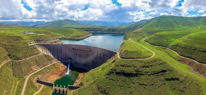
The title Katse Dam Relics: Lesotho's Submerged Villages focuses on the heritage associated with the Katse Dam and the possibility that earlier settlement remains were affected by the formation of its reservoir. The exact number, location, and character of any submerged villages must be established through historical and environmental records rather than assumed from the existence of the dam alone.

Even where buildings are not physically submerged, the creation of a reservoir can change access to land, routes, grazing areas, and places of cultural importance. Understanding these changes requires attention to both archaeological remains and the experiences of affected communities.

The Lesotho Highlands Water Project

Katse Dam is a major component of the Lesotho Highlands Water Project, a large infrastructure initiative designed to transfer water from Lesotho's highlands to South Africa while also providing associated benefits within Lesotho.

The project required extensive engineering, including dam construction, tunnels, roads, and related facilities. These developments changed parts of the highland landscape and created a large reservoir behind the dam.

The project has significant economic and strategic importance because Lesotho's mountainous environment collects water that contributes to regional river systems. At the same time, major infrastructure projects can have substantial local consequences, especially when land is acquired, settlements are relocated, or access to resources changes.

A balanced history of Katse Dam should therefore examine both its engineering achievements and the social and environmental changes associated with its development.

What Happens When a Reservoir Is Created?

When a reservoir fills, water covers the lower parts of the landscape behind a dam. The affected area may include riverbanks, fields, paths, buildings, archaeological sites, and places used for grazing or gathering natural resources.

Not all affected places are necessarily villages, and not every structure becomes permanently submerged. Some areas may be flooded only under particular water levels, while others remain above the reservoir.

Before construction, environmental and heritage assessments may identify archaeological sites and places of cultural significance. Where remains are at risk, surveys or excavations can sometimes document them before flooding occurs.

However, the quality and completeness of this record depend on the scope of the investigations, the time available, the resources provided, and the accessibility of the landscape. Some archaeological information may remain incomplete even after a formal assessment.

Archaeology Before Flooding

Archaeological work associated with dam construction is often described as rescue or salvage archaeology. Its purpose is to record evidence that might otherwise be destroyed or made inaccessible by development.

Researchers may survey the area, map settlement remains, collect surface artefacts, and excavate selected locations. They may document stone foundations, livestock enclosures, pottery, tools, burials, or other evidence of past activity where present and appropriate to investigate.

The archaeological record can help establish how people used the landscape before the reservoir was created. It may reveal settlement patterns, household economies, farming practices, livestock management, and connections between communities.

Yet salvage archaeology has limitations. It often operates under strict deadlines and may focus on sites considered most likely to be affected. The resulting record may not represent every settlement or every aspect of local history.

The Human Meaning of Submerged Landscapes

A village is not simply a group of buildings. It is a place connected to family histories, daily routines, community relationships, and memories. Fields may be associated with generations of work, while paths connect households to relatives, schools, religious institutions, and markets.

When a reservoir changes the landscape, the effects may continue long after construction is completed. People may need to relocate, change their livelihoods, or travel different routes to reach familiar places. Compensation and resettlement arrangements can influence how households adapt, but they do not necessarily replace the social and cultural value of the places affected.

These experiences should not be reduced to the idea that a village has simply disappeared beneath water. Communities may continue elsewhere, maintaining relationships and memories while adapting to new circumstances.

Oral histories can preserve details that official project records may not fully capture. They may describe former settlement locations, land use, local place names, and the ways people experienced relocation. Such accounts should be collected respectfully and with the consent of participants.

Distinguishing Archaeological Relics from Modern Ruins

The word “relics” can refer to surviving objects, structures, or traces of an earlier way of life. At Katse, any claim about submerged archaeological remains must be supported by reliable evidence.

Researchers might use historical maps, aerial photographs, engineering records, heritage surveys, and oral accounts to identify former settlement locations. Where water levels permit, some exposed areas may be examined, but underwater archaeological investigation requires specialized methods and safety procedures.

A structure visible near a reservoir's edge may not necessarily be ancient. It could belong to a relatively recent settlement or infrastructure project. Similarly, an object recovered from reservoir sediment may have been transported by water rather than remaining at its original location.

Dating and contextual evidence are therefore essential before a site can be described as prehistoric, Iron Age, or associated with a particular historical community.

Environmental Change and Archaeological Preservation

Reservoirs alter local water levels, sediment movement, and shoreline conditions. These changes can affect archaeological deposits in different ways.

Permanent submersion may reduce exposure to some forms of weathering, but it does not guarantee preservation. Water movement, changing oxygen conditions, erosion, and chemical processes can damage structures and artefacts. Shoreline fluctuations can also expose remains to repeated cycles of wetting, drying, and physical disturbance.

The best conservation strategy is often to document vulnerable sites before they are affected and to monitor important remains where practical.

Lessons for Future Infrastructure

The experience of large dam projects demonstrates why heritage planning should begin early. Archaeological surveys, community consultation, historical documentation, and resettlement planning should be integrated into project development rather than treated as secondary concerns.

Communities should have meaningful opportunities to identify places that matter to them and to contribute to decisions about documentation, access, and preservation. Museum collections and archives can help keep records accessible, while community-led projects can preserve memories of transformed landscapes.

Conclusion

Katse Dam's heritage provides an important opportunity to examine the relationship between infrastructure, archaeological preservation, and community displacement in Lesotho. The specific history of any submerged village or archaeological site must be established through reliable records, but the broader issues are clear: reservoirs can permanently transform landscapes that contain generations of human history.

Understanding this transformation requires more than identifying objects beneath the water. It means documenting former settlements, preserving archaeological evidence, listening to affected communities, and recognizing that the loss of a familiar landscape can involve social and cultural changes as well as physical ones.

Mohale Dam Sites: Lesotho's Iron Age

October 4, 2026

Introduction

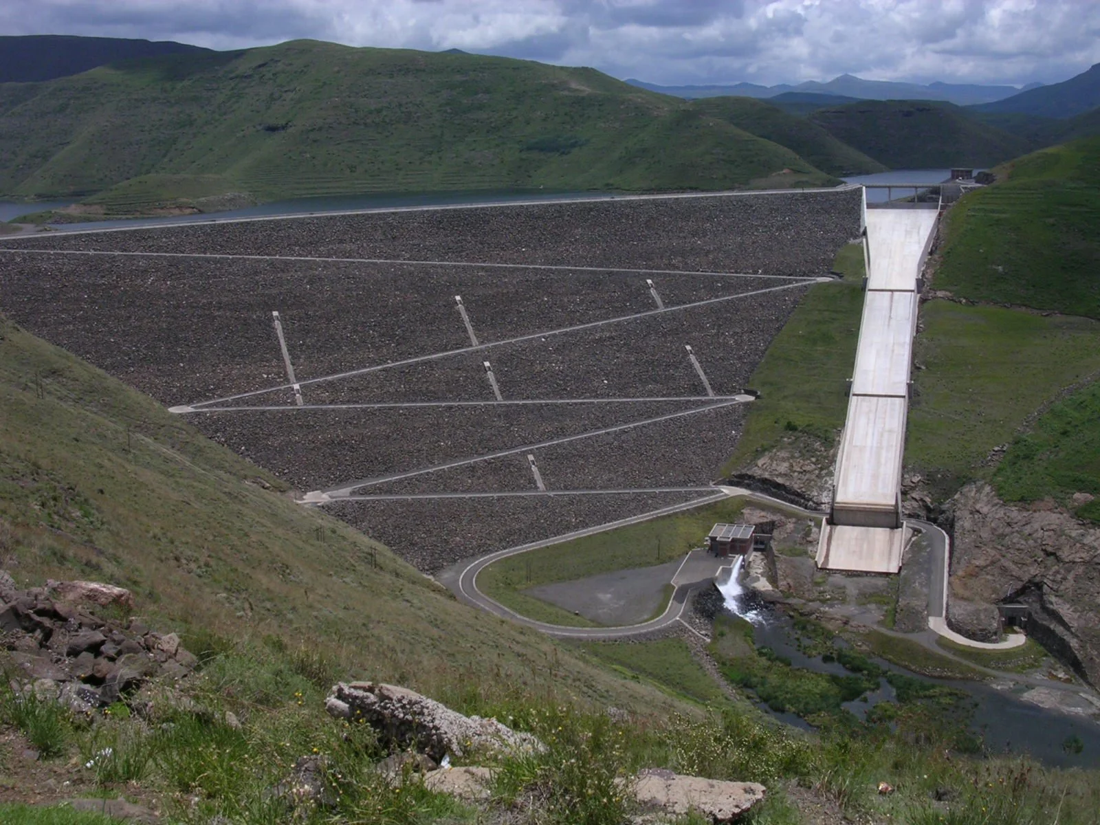
Lesotho's archaeological record reflects a long history of people adapting to mountainous terrain, managing livestock, cultivating crops, making tools, and interacting with neighboring communities. The title Mohale Dam Sites: Lesotho's Iron Age focuses on the potential archaeological significance of areas associated with Mohale Dam and the wider history of Iron Age settlement.

As with other large infrastructure projects, the creation of a reservoir can affect archaeological sites by flooding land, changing access, and exposing remains to new environmental conditions. The precise dates and cultural affiliations of any Iron Age sites around Mohale Dam must be established through archaeological evidence. The wider context, however, helps explain what researchers may learn from settlements and artefacts associated with this period.

Understanding the Iron Age in Lesotho

The term “Iron Age” is used by archaeologists to describe periods in which iron technology became part of the material culture of communities. It does not mean that every household used iron tools exclusively, nor does it imply that stone tools immediately disappeared.

In Southern Africa, ironworking developed alongside other technologies and economic practices. Farming, livestock keeping, pottery production, and the use of stone and organic materials could all remain important within Iron Age communities.

The timing of these developments varied between regions. Archaeologists therefore establish local chronologies using dated deposits, artefact styles, settlement evidence, and comparisons with other sites.

In Lesotho, the mountainous environment influenced how communities used land and organized settlement. Valleys, slopes, water sources, and grazing areas created different opportunities for cultivation and livestock management.

Ironworking and Technological Knowledge

Ironworking required knowledge of raw materials, fuel, heat, and the processes needed to produce usable metal. Where suitable iron ore was available, craftspeople could extract and process it through specialized techniques. The production process required careful control and considerable practical experience.

Iron objects could be used for cutting, woodworking, agriculture, and other tasks. Their value depended on the quality of the metal, the skill of the craftsperson, and the needs of the household or community.

However, the presence of an iron object does not prove that iron was produced at the location where it was found. The object may have been imported, exchanged, inherited, or transported from another settlement.

Evidence of local ironworking may include furnaces, slag, tuyères or air-delivery components, ore fragments, and other production remains. Even these materials require careful interpretation because metalworking debris can be moved or reused.

Farming, Livestock, and Domestic Life

Iron Age settlements in Southern Africa were often associated with combinations of cultivation and livestock keeping, although the importance of each activity varied according to local conditions.

Cultivation required knowledge of soils, rainfall, planting seasons, and crop management. Livestock keeping required access to grazing and water, as well as strategies for protecting animals and managing disease or seasonal shortages.

These activities could complement one another. Crops provided food, while animals supplied milk, meat, hides, and other resources. Manure could improve cultivated soils, although its use depended on local farming practices.

Archaeological evidence may include charred seeds, animal bones, pottery, grinding stones, storage features, and domestic structures. Each type of evidence offers only part of the picture, so researchers combine them to reconstruct household economies.

Pottery and Cultural Connections

Pottery can help identify technological traditions and interactions between settlements. Vessel shapes, decorative patterns, clay composition, and manufacturing methods may be compared across sites to investigate similarities and differences.

A resemblance between pottery assemblages may indicate shared traditions or contact between communities. It does not necessarily prove that the same people lived at both sites, since styles and techniques can spread through exchange, marriage, movement, or imitation.

Pottery also provides evidence of everyday activities such as cooking, storage, and food processing. Residue analysis may sometimes reveal traces of materials once held in vessels, although preservation and contamination must be considered.

When pottery is recovered from a secure archaeological layer, it can contribute to a site's chronology. However, researchers must account for the possibility that older and younger objects became mixed through later disturbance.

Mohale Dam and Archaeological Survey

The construction of Mohale Dam and its reservoir created a need to consider the cultural and environmental heritage of the affected landscape. Before flooding, archaeological surveys and assessments can identify places where material evidence may be at risk.

Researchers may document settlement remains, pottery, stone tools, metal objects, and other finds. They may also record caves, rock shelters, paths, and other features that help explain how people used the area.

The presence of Iron Age material must be established through careful analysis. A stone wall alone does not reveal its date, and pottery or metal objects found on the surface may have been displaced. Excavation and scientific dating, where possible, can help establish the sequence of occupation.

The archaeological record may also reveal repeated use of a location over different periods. A place occupied during the Iron Age could later have been used by other communities, meaning that its history cannot be reduced to a single cultural phase.

The Effects of Reservoir Creation

The creation of a reservoir can make archaeological sites inaccessible, alter shorelines, and change the movement of sediment. Some remains may become submerged, while others may be exposed as water levels fluctuate.

Submersion does not necessarily preserve archaeological material indefinitely. Water movement, erosion, changing chemical conditions, and repeated exposure can damage deposits. For this reason, documentation before flooding is particularly important.

The effects extend beyond archaeological objects. The landscape may contain former fields, grazing areas, paths, and settlement locations that remain important in community memory. Oral histories can help record how people used these places before the reservoir transformed the area.

Interpreting the Evidence Responsibly

A strong account of Mohale's Iron Age sites should distinguish between three questions: when people occupied the area, what activities they carried out, and how those activities changed over time.

Dating helps establish chronology, while artefact and environmental analysis provide evidence of daily life. Settlement mapping reveals how households related to one another and to the wider landscape.

Researchers should avoid attributing every artefact to one community or assuming that a particular archaeological tradition corresponds directly to a modern ethnic identity. Cultural practices can change, overlap, and spread between groups.

Consultation with local communities and heritage institutions is important for establishing site histories and determining how findings should be presented to the public.

Conservation and Public Education

Archaeological remains around dams require careful management. Documentation, museum interpretation, digital records, and public education can preserve knowledge even where physical access becomes difficult.

Community participation can help ensure that research recognizes the human significance of the landscape. Educational materials should explain both the scientific value of the archaeological record and the changes experienced by people whose lives were connected to the affected area.

Conclusion

Mohale Dam's archaeological context provides an important opportunity to investigate Iron Age settlement, technology, farming, livestock management, and cultural interaction in Lesotho. The exact history of individual sites depends on reliable archaeological evidence, but the wider questions are significant for understanding how people adapted to the highlands over time.

By combining archaeological survey, scientific dating, artefact analysis, environmental research, and community knowledge, researchers can reconstruct the lives of earlier inhabitants and document how the modern reservoir changed the landscape. This approach preserves a more complete record of Lesotho's past, connecting ancient technologies and settlement patterns with the modern history of infrastructure and environmental transformation.

Puye Cliff Dwellings: New Mexico's Tsankawi Trails

October 3, 2026

Introduction

High on the volcanic mesas of northern New Mexico, where the landscape rises above the valleys surrounding the modern communities of Santa Clara and Los Alamos, a remarkable archaeological landscape preserves the homes, trails, agricultural areas, and rock shelters of ancestral Tewa communities. Among the most important of these places are the Puye Cliff Dwellings and the nearby Tsankawi landscape.

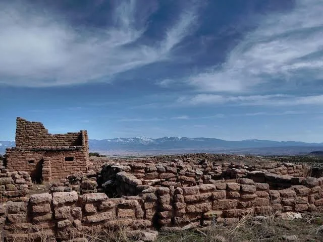
The Puye complex is particularly significant because it preserves evidence of communities adapting to a dramatic volcanic environment. Rather than constructing settlements only on open ground, ancestral Pueblo people used the soft volcanic tuff itself. They carved rooms into cliffs, constructed masonry buildings on mesa tops, created pathways along exposed rock faces, and organized settlements around the practical requirements of agriculture, water, movement, storage, and community life.

Today, Puye Cliff Dwellings are recognized as the ancestral homeland of the Santa Clara Pueblo people. The site is not simply an abandoned archaeological ruin. It is part of a living cultural landscape whose significance extends beyond architecture and artifacts. The modern interpretation of Puye emphasizes its connection to the ancestors of today's Santa Clara Pueblo community.

The nearby Tsankawi landscape provides another extraordinary expression of this relationship between people and volcanic terrain. Its trails include narrow passages, hand-and-foot holds, ladders, cavates, petroglyphs, and mesa-top settlement remains. The National Park Service describes Tsankawi as part of the ancestral lands of modern San Ildefonso Pueblo and notes that ancestral Pueblo people used the soft volcanic rock for houses while practicing dry farming on the surrounding mesa lands.

The Volcanic Landscape of Northern New Mexico

Understanding Puye requires understanding its geology.

The region was shaped by volcanic activity associated with the Jemez Mountains. Vast deposits of volcanic ash and other materials eventually formed relatively soft tuff formations. Unlike hard granite or massive sandstone, tuff can be worked comparatively easily using stone and wooden tools.

This geological characteristic created opportunities for architecture.

People could carve shallow rooms directly into cliff faces while simultaneously building masonry structures on the mesa above. The resulting landscape combined natural geology and human construction.

This is one reason the archaeological remains can appear unusual to modern visitors. A structure may not look like a conventional building. A room might consist partly of a carved cavity and partly of a constructed wall. A pathway may follow a natural ledge but contain deliberately carved steps and handholds.

The architecture therefore represents an interaction between geology and human planning.

The Puye Settlement

Puye developed into a substantial ancestral Pueblo settlement.

The archaeological complex contains cliff dwellings, mesa-top remains, agricultural areas, and pathways. The cliff dwellings were not isolated shelters. They formed part of a broader settlement system.

The location offered several practical advantages.

The cliffs provided protected spaces for habitation and storage. The mesa offered relatively open surfaces where people could cultivate crops and move between settlement areas. The surrounding valleys and mountains supplied wild plants, animals, fuel, and stone resources.

Agriculture remained fundamental.

Like other ancestral Pueblo communities in the Southwest, the inhabitants depended heavily on maize and other cultivated foods while continuing to exploit wild resources. Farming in this environment required careful management of limited moisture.

Dry farming was particularly important.

Rather than relying entirely on large irrigation systems, communities could take advantage of seasonal precipitation, soil characteristics, runoff, and carefully selected agricultural locations.

Architecture Carved into the Cliff

One of the most remarkable aspects of Puye is the use of cliff faces as architectural space.

The soft volcanic tuff could be excavated to produce rooms and sheltered areas. The resulting cavities could be combined with masonry walls, roofs, storage spaces, and other architectural features.

This approach demonstrates an important principle of Southwestern archaeology: architecture cannot be understood independently from the environment.

The builders were not simply constructing houses wherever convenient. They were exploiting specific properties of the landscape.

A cliff offered elevation, shelter, visibility, and a natural architectural foundation.

At the same time, living in such places required movement systems.

Trails and ladders connected different levels of the settlement. The relationship between mesa top and cliff face was therefore essential to everyday life.

The Trails of Tsankawi

Tsankawi provides some of the clearest evidence of how ancestral Pueblo people physically moved through this environment.

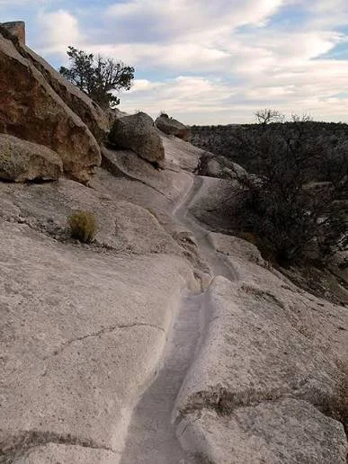
The modern trail follows portions of pathways associated with ancestral use. Visitors encounter narrow trenches, carved steps, exposed ledges, ladders, and mesa-top areas. The National Park Service describes the modern Tsankawi route as approximately 1.5 miles and notes that ladders are an essential part of the experience.

These pathways are important archaeological evidence in their own right.

A trail tells us about more than transportation.

It can reveal how different areas of a settlement were connected, where people repeatedly traveled, and how the physical landscape shaped daily routines.

Some routes required climbing or moving through narrow passages. Such paths may initially appear difficult to modern visitors, but for people familiar with the landscape, they formed part of a functioning transportation system.

Cavates: Rooms Cut into Volcanic Tuff

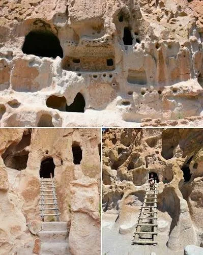
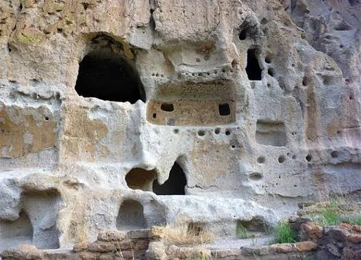
One of Tsankawi's most distinctive features is the presence of cavates, human-carved rooms excavated into volcanic cliffs.

These spaces are particularly valuable archaeologically because they preserve evidence of how people modified geological formations for human purposes.

Cavates could serve different functions, and archaeologists must be cautious about assigning a single purpose to every room.

Some spaces may have been domestic. Others could have been used for storage, work, ritual, or combinations of these activities.

The interiors may preserve traces of architectural modification, soot, plaster, pigment, tool marks, and other evidence.

The absence of modern construction materials makes such spaces especially important for reconstructing ancient life.

Petroglyphs and Cultural Memory

Tsankawi also contains rock imagery.

Petroglyphs are images produced by modifying the rock surface through pecking, carving, scraping, or related techniques. They may depict humans, animals, geometric forms, abstract symbols, or other imagery.

Interpreting these images is difficult.

Archaeologists cannot automatically translate a petroglyph into a specific meaning simply by looking at it. The cultural knowledge required to understand an image may not survive in written form.

This is why Indigenous perspectives are particularly important.

The National Park Service explicitly recognizes that Tsankawi contains tangible and intangible connections for descendants of the people who lived in these landscapes. It also warns that modern graffiti can be deeply disturbing because it damages evidence connected to ancestral identity and memory.

Life on the Mesa

Life at Tsankawi and Puye required adaptation.

The mesa environment could be dry and exposed. Farming required careful timing and knowledge of precipitation. People had to understand seasonal changes, soil conditions, local plants, and animal behavior.

The National Park Service notes that ancestral inhabitants became highly skilled in dry farming while also hunting available wildlife and collecting resources provided by the surrounding environment.

This combination of farming and gathering was not unusual in the Southwest.

Agricultural communities did not necessarily abandon wild foods after adopting domesticated crops. Instead, subsistence could remain diverse.

Corn was extremely important, but people also depended on wild plants, game, gathered resources, and stored food.

Why the Cliffs Matter

It is tempting to describe cliff dwellings as defensive structures.

Sometimes elevation and difficult access could certainly provide security.

However, archaeologists increasingly recognize that cliff locations should not automatically be interpreted as fortresses.

There were many possible reasons to construct or occupy spaces along cliffs:

  • protection from weather

  • storage

  • architectural convenience

  • proximity to water or agricultural land

  • social organization

  • ritual activities

  • visibility

  • inherited settlement traditions

  • defense or security

The meaning of a particular structure must therefore be established through archaeological context rather than appearance alone.

Migration and the Changing Southwest

Puye and Tsankawi belong to a much larger history of population movement across the Southwest.

Ancestral Pueblo communities did not remain permanently fixed in one settlement. Communities expanded, contracted, relocated, and reorganized over centuries.

At Bandelier, for example, archaeological evidence documents major ancestral Pueblo reoccupation beginning around A.D. 1150 and continuing into the sixteenth century, with connections to broader population movements from the Four Corners region.

These movements should not necessarily be interpreted as simple "disappearances."

When an archaeological settlement was abandoned, its inhabitants did not vanish.

People moved to other communities, joined relatives, established new settlements, or became ancestors of later Pueblo populations.

The archaeological record therefore represents movement rather than disappearance.

Puye and Modern Santa Clara Pueblo

One of the most important aspects of Puye is its continuing connection to living Pueblo communities.

The site is recognized as the ancestral homeland of today's Santa Clara Pueblo people.

This changes how the archaeology should be presented.

Rather than treating Puye exclusively as a window into a vanished civilization, it is more accurate to understand it as a place connected to continuing Indigenous history.

Modern Pueblo communities preserve traditions, identities, oral histories, languages, artistic practices, and relationships to landscapes that provide essential context for interpreting archaeological evidence.

Archaeological Preservation

Volcanic tuff is comparatively soft.

That makes it useful for carving—but also vulnerable.

Weathering, water erosion, freeze-thaw cycles, vegetation, visitor traffic, and human vandalism can damage archaeological surfaces.

Tsankawi is particularly sensitive because visitors physically walk across archaeological terrain.

The National Park Service therefore emphasizes staying on designated trails and avoiding disturbance to artifacts, plants, rocks, and architectural remains.

This is not merely a matter of preserving attractive ruins.

Archaeological context is evidence.

A pottery fragment left beside a wall can provide information about chronology and activity. Once removed, that relationship may be permanently lost.

Conclusion

Puye Cliff Dwellings and the Tsankawi trails represent an extraordinary example of how ancestral Pueblo communities transformed a volcanic landscape into a lived environment.

Their architecture was not imposed upon the landscape from outside. It emerged from the properties of the rock itself.

Cliffs became rooms.

Ledges became pathways.

Mesa surfaces became agricultural landscapes.

Petroglyphs became part of the cultural record.

And the entire landscape became embedded within generations of Pueblo history.

The trails of Tsankawi are therefore more than hiking routes. They are physical evidence of movement, adaptation, architecture, and cultural continuity.

For archaeologists, they offer an opportunity to study ancient settlement organization and environmental adaptation. For descendants, they remain part of a much deeper cultural landscape.

That combination of archaeological evidence and living heritage is what makes Puye and Tsankawi among the most important ancestral Pueblo landscapes of northern New Mexico.

Sources: National Park Service; Puye Cliff Dwellings/Santa Clara Pueblo cultural information; archaeological research on Bandelier and ancestral Pueblo settlement.

Bandelier: New Mexico's Ancestral Pueblo Tuff Houses

October 3, 2026

Introduction

Few archaeological landscapes demonstrate the relationship between geology and human settlement as clearly as Bandelier National Monument in northern New Mexico.

Located within a spectacular landscape of volcanic cliffs, canyons, mesas, forests, and streams, Bandelier preserves thousands of years of human activity. Its most recognizable archaeological features are the ancestral Pueblo homes carved into soft volcanic tuff, along with masonry pueblos, kivas, agricultural features, trails, and rock imagery.

The site is often described through its dramatic cliff dwellings, but that description can obscure the complexity of the community that once occupied the region.

Bandelier was not simply a collection of caves.

It was a landscape in which people farmed, built houses, stored food, traveled between settlements, practiced ceremonies, processed resources, and maintained relationships with the surrounding environment.

The Geological Foundation

Bandelier's archaeology begins with volcanic geology.

The cliffs consist largely of volcanic tuff produced by ancient eruptions. Ash and volcanic debris accumulated, compacted, and eventually formed relatively soft rock.

For prehistoric builders, this material was extremely useful.

The tuff could be carved using relatively simple tools. Instead of constructing every room entirely from stone, people could excavate cavities directly into cliff walls.

This produced the distinctive cavate rooms associated with Bandelier.

The combination of carved rooms and masonry construction is one of the defining characteristics of the archaeological landscape.

Human Occupation Before the Pueblo Communities

Bandelier has a long human history.

The National Park Service notes evidence of hunter-gatherer occupation reaching back into the Paleoindian period. A projectile point found in the monument represents some of the earliest known human evidence in the area.

The landscape therefore cannot be reduced to the period of the famous cliff dwellings.

Human use occurred over thousands of years.

People hunted, gathered plants, moved across the landscape, and gradually incorporated agriculture into their economies.

The development of farming was transformative.

Domesticated maize provided a more predictable source of calories, allowing communities to invest more heavily in permanent architecture and food storage.

The Rise of Ancestral Pueblo Communities

The major ancestral Pueblo occupation of Bandelier occurred much later.

The National Park Service identifies a major reoccupation beginning around A.D. 1150 and continuing into approximately A.D. 1550.

This period coincided with broader demographic and cultural transformations across the Southwest.

Communities associated with the Four Corners region were experiencing environmental pressures, changing settlement patterns, and population movements.

Bandelier became part of this wider world.

Tuff Houses

The phrase "tuff houses" captures the distinctive architecture of Bandelier.

Instead of constructing houses entirely as independent buildings, inhabitants often combined masonry walls with the natural cliff.

A room could therefore have:

  • a carved rear wall

  • masonry side walls

  • wooden roof beams

  • packed-earth floors

  • plastered surfaces

  • storage spaces

  • connecting pathways

This created architecture that was simultaneously natural and constructed.

The distinction between "cave" and "house" can therefore be misleading.

These were intentionally modified living spaces.

The Cavates

Cavates are among Bandelier's most recognizable archaeological features.

A cavate is essentially a room excavated into soft volcanic rock.

The excavation process left physical evidence.

Tool marks can survive on the walls. Smoke staining can provide clues about the use of fire. Plaster remnants may indicate attempts to improve interior surfaces.

Some cavates are relatively small, while others form larger complexes.

Their precise functions varied.

Some were undoubtedly associated with domestic activity, but archaeologists must avoid assuming that every cavity served the same purpose.

Long House and Pueblo Architecture

Bandelier's architecture also includes substantial masonry pueblos.

Long House, for example, was constructed along the base of a cliff and reached several stories in some areas. The structure illustrates how ancestral Pueblo builders combined masonry architecture with natural geological walls.

This was not primitive construction.

Multi-story buildings required planning, materials, labor, structural knowledge, and cooperation.

Timber had to be obtained and transported.

Stone had to be shaped and positioned.

Mud was needed for mortar and plaster.

Roof systems required beams and smaller branches.

Food production had to support the people participating in construction.

Architecture therefore provides evidence for social organization.

A large pueblo represents not merely a collection of rooms but a coordinated community.

Tyuonyi

One of Bandelier's best-known archaeological features is Tyuonyi, a large circular or roughly circular pueblo structure.

Its walls demonstrate the scale of communal architecture.

The settlement included numerous rooms arranged around an open central space.

Central plazas were important elements of many Pueblo communities because they provided shared space for social, economic, and ceremonial activities.

The architectural organization suggests that Bandelier was a community rather than an assortment of unrelated households.

Kivas and Community Life

Kivas are another critical component of ancestral Pueblo architecture.

These circular, often semi-subterranean spaces are generally associated with ceremonial and social activities.

However, it is important to avoid reducing kivas to a simplistic definition such as "religious rooms."

Archaeological interpretations suggest that kivas could be involved in ritual, social organization, community gatherings, and other activities.

The exact significance of individual structures depended on time and place.

Modern Pueblo communities are essential sources of perspective when archaeologists consider the meaning of ancestral ceremonial architecture.

Farming in the Canyon

The canyon environment was not simply a backdrop.

It provided resources.

People cultivated crops on suitable land while also collecting wild plants and hunting animals.

Maize, beans, and squash were fundamental crops across many Southwestern agricultural communities.

Yet agriculture in a semi-arid environment was challenging.

Rainfall could be unpredictable.

Drought could reduce harvests.

Soil could erode.

People therefore needed extensive environmental knowledge.

Agricultural strategies included choosing suitable locations, managing soil, conserving moisture, storing food, and combining cultivated crops with wild resources.

Water and Survival

Water was central to Bandelier life.

Streams and seasonal water sources provided drinking water and supported plants and wildlife.

But water availability could fluctuate.

The architecture and settlement distribution of Bandelier should therefore be studied together with its hydrology.

Where people lived was partly influenced by access to water, agricultural land, natural shelters, and transportation routes.

The canyon was both a resource and a constraint.

Its cliffs offered protection and architectural opportunities, but steep terrain could make movement difficult.

Trails as Archaeological Evidence

The paths connecting Bandelier's archaeological features are important.

Trails reveal how people navigated the landscape.

They can connect agricultural fields with houses, houses with water sources, and settlements with ceremonial locations.

A modern trail is not necessarily identical to an ancient pathway, but many landscapes preserve evidence of repeated human movement.

At Tsankawi, another section of Bandelier, the National Park Service notes that visitors can walk routes associated with ancestral Pueblo use and encounter carved pathways, cavates, petroglyphs, and the remains of a mesa-top village.

Why People Built on Cliffs

The popular imagination often assumes that cliff dwellings were primarily defensive.

The reality was probably more complicated.

Cliffs offered several advantages.

They could provide:

  • shade

  • shelter

  • storage

  • architectural foundations

  • access to protected spaces

  • visibility

  • proximity to agricultural areas

Security may sometimes have mattered, but archaeology does not support a single explanation for every cliff dwelling.

The meaning of architecture must be understood within its specific context.

The Wider Pueblo World

Bandelier was part of a much larger ancestral Pueblo world.

Connections existed between communities across New Mexico, Arizona, Utah, and Colorado.

Archaeologists identify similarities and differences through:

  • pottery styles

  • architectural techniques

  • agricultural systems

  • settlement patterns

  • stone tools

  • trade materials

  • ceremonial architecture

The National Park Service emphasizes that Bandelier, Mesa Verde, and Chaco Canyon were all associated with the broader ancestral Pueblo tradition, although they were occupied during different periods and developed distinctive local histories.

This regional perspective is essential.

No single site tells the complete story.

Population Movement

The archaeological history of Bandelier is also connected to migration.

Communities in the Four Corners and Rio Grande regions experienced major population changes during the late prehistoric period.

The movement of people should not be interpreted as cultural disappearance.

Modern Pueblo peoples are descendants of ancestral communities that experienced generations of movement and reorganization.

Consequently, the archaeological record is part of an ongoing Indigenous history.

Archaeological Research

Bandelier has played an important role in Southwestern archaeology.

Researchers have used excavation, architectural recording, ceramic analysis, tree-ring dating, paleoenvironmental reconstruction, and other techniques to understand the site's history.

Tree-ring evidence can be particularly valuable because wooden beams sometimes preserve annual growth patterns.

These records can provide extremely precise chronological information when suitable wood samples survive and can be correlated with regional tree-ring sequences.

Ceramics provide another important chronological and cultural tool.

Changes in pottery style can help archaeologists identify different periods and connections between communities.

Preservation Challenges

The same geology that made Bandelier attractive to ancient builders creates preservation challenges today.

Tuff is relatively soft.

Rain, snow, freezing temperatures, erosion, vegetation, rockfall, and human contact can gradually alter archaeological features.

Modern visitors therefore have an unusual responsibility.

Walking directly on fragile archaeological surfaces can accelerate erosion.

Touching walls can transfer oils and moisture.

Removing artifacts destroys archaeological context.

The National Park Service repeatedly emphasizes that archaeological remains should remain undisturbed.

Bandelier as a Living Cultural Landscape

One of the most important developments in archaeological interpretation is the recognition that ancestral Pueblo sites are not simply "dead civilizations."

The people who built these communities have descendants.

Modern Pueblo communities maintain relationships with ancestral places through oral traditions, cultural practices, ceremonies, and identity.

The National Park Service describes these landscapes as places containing both tangible and intangible connections to Pueblo descendants.

This perspective changes the language archaeologists use.

A site may be "ruined" architecturally while remaining culturally alive.

Conclusion

Bandelier is one of the most extraordinary archaeological landscapes in North America because it demonstrates how human communities adapted architecture to geology.

The volcanic tuff became a building material.

Cliffs became walls.

Cavates became rooms.

Mesa surfaces became agricultural landscapes.

Kivas became communal spaces.

Trails connected the different parts of the settlement.

The resulting landscape was not merely a collection of archaeological remains. It was a functioning community shaped by environmental knowledge, social cooperation, agriculture, architecture, and cultural tradition.

Today, Bandelier provides archaeologists with evidence for understanding ancestral Pueblo lifeways while simultaneously remaining connected to living Pueblo communities.

Its importance therefore lies not only in the remarkable structures that survive but in the human stories those structures continue to carry.

Frijoles Canyon: New Mexico's Cavate Rooms

October 3, 2026

Introduction

Frijoles Canyon is one of the most archaeologically significant landscapes within Bandelier National Monument.

Cut deeply into the volcanic terrain of northern New Mexico, the canyon contains archaeological remains that reveal how ancestral Pueblo communities adapted to a landscape of soft volcanic tuff, limited water, steep cliffs, forests, and agricultural possibilities.

Among its most fascinating features are the cavate rooms—human-made chambers carved directly into the canyon's soft rock.

At first glance, these rooms can look like natural caves.

They are not.

They are architectural spaces deliberately excavated and modified by people.

Their existence demonstrates a sophisticated understanding of local geology and an ability to transform natural formations into usable domestic and communal environments.

The Geography of Frijoles Canyon

Frijoles Canyon is a dramatic environment.

Its steep walls rise above the canyon floor, while volcanic formations create alcoves, cliffs, ledges, and sheltered spaces.

The canyon also contains vegetation and water resources that made human occupation possible.

The landscape was attractive because it brought several resources together.

People could obtain water, gather plants, hunt animals, cultivate crops, and construct buildings within a relatively compact area.

Yet the terrain was challenging.

Movement required climbing and navigating uneven surfaces.

Agricultural land was limited.

Weather conditions could change rapidly.

The inhabitants therefore needed extensive knowledge of the environment.

What Is a Cavate?

The term cavate refers to a room or cavity intentionally excavated into soft volcanic tuff.

The word is particularly associated with the archaeology of the Southwest.

Cavates should not be confused with naturally occurring caves.

Their walls often show evidence of deliberate excavation.

Tool marks, flattened surfaces, niches, plaster remains, smoke deposits, and architectural modifications can reveal how people used and maintained them.

The rooms vary considerably.

Some are small.

Others form interconnected spaces.

Their differences suggest that they did not necessarily have identical functions.

How Were the Rooms Created?

The softness of volcanic tuff was crucial.

The rock could be excavated with stone tools and other relatively simple implements.

Workers could gradually remove material from a cliff face, creating a chamber large enough for human use.

The process would still have required considerable labor.

Excavation produced debris that had to be removed.

Surfaces had to be prepared.

Entrances had to be designed.

Some rooms required additional construction to make them comfortable or structurally secure.

In this sense, the cavates represent an architectural technology adapted to local geology.

Why Carve Instead of Build?

One obvious question is why people would excavate rooms instead of simply building houses.

The answer probably involves several factors.

A carved room could provide excellent thermal buffering.

Thick rock surrounding an interior space could moderate temperature fluctuations.

The rock also provided a ready-made rear wall.

A cavate could require less masonry than a completely freestanding building.

It could also provide shelter from sunlight and weather.

The location of a room might additionally have social or ceremonial importance.

Therefore, cavates should not be interpreted as evidence of technological simplicity.

They represent technological adaptation.

Domestic Life

Some cavates were associated with everyday activities.

Archaeologists can investigate domestic use through artifacts and deposits.

Pottery fragments can indicate cooking or storage.

Stone tools can reveal food processing and manufacturing.

Plant remains can indicate agricultural practices.

Animal bones can provide evidence of hunting and diet.

Charcoal can reveal the use of fire.

The combination of these materials helps archaeologists reconstruct daily life.

Food and Agriculture

The people of Frijoles Canyon were agriculturalists, but farming in the region was difficult.

Maize required adequate moisture.

Beans provided additional nutritional value.

Squash contributed food and other useful plant materials.

Agriculture also required seed selection, planting knowledge, soil management, harvesting, and storage.

Wild foods remained important.

The distinction between "farmer" and "hunter-gatherer" is therefore not absolute.

Ancestral Pueblo communities could practice agriculture while continuing to collect wild plants and hunt animals.

Storage and Food Security

Food storage was essential in an environment where harvests could vary.

Storage facilities allowed communities to preserve surplus crops for future use.

This was particularly important during drought or poor harvest years.

Archaeological storage spaces can therefore tell us about economic planning.

A household that stored significant quantities of food had a different relationship with the environment than a group relying entirely on immediate consumption.

Storage also raises questions about social organization.

Who controlled stored food?

Was food stored by individual households, extended families, or communities?

Archaeology can sometimes provide evidence, but these questions remain difficult to answer conclusively.

Long House

Frijoles Canyon contains one of Bandelier's best-known architectural complexes: Long House.

Unlike a simple cavate, Long House represents substantial masonry construction against a cliff face.

The building reached multiple stories in some sections.

Its existence demonstrates the ability of ancestral Pueblo builders to coordinate large construction projects.

The combination of natural cliff and masonry architecture also demonstrates continuity with the broader principle of using geology as part of architecture.

Tyuonyi and Community Organization

Nearby Tyuonyi provides another important example.

Its circular arrangement of rooms around an open central area suggests communal organization.

Archaeologists can examine such architectural layouts to investigate household relationships, public space, movement, and community structure.

A settlement containing numerous households requires some form of cooperation.

Construction, agriculture, water management, ceremonies, food storage, and defense—where necessary—could all involve collective activity.

Architecture therefore provides evidence not only about buildings but about social relationships.

The Meaning of Kivas

Frijoles Canyon also contains kivas.

Kivas are among the most recognizable architectural forms associated with ancestral Pueblo communities.

They are often circular and partly subterranean.

Archaeological evidence indicates that they were associated with ceremonial and social activities.

However, modern interpretations must be careful.

It is easy to impose a single category such as "religious building" onto a structure that may have served multiple social purposes.

Indigenous consultation and comparative archaeological research help create more nuanced interpretations.

Rock Imagery

Canyons such as Frijoles also contain rock imagery.

Petroglyphs and pictographs can provide evidence of symbolic communication.

Some images may be associated with animals, people, geometric designs, or other motifs.

Dating rock art can be difficult.

Unlike pottery or wooden architecture, rock imagery does not always contain materials that can be directly dated.

Archaeologists therefore use several methods:

  • superimposition

  • weathering

  • pigment analysis

  • associated archaeological deposits

  • stylistic comparison

  • geological context

Each method has limitations.

Climate and Environmental Change

Environmental change is crucial to understanding Frijoles Canyon.

The Southwest experienced significant climatic fluctuations during the period of ancestral Pueblo occupation.

Droughts could affect crops, water sources, and food supplies.

Long-term climate records derived from tree rings and other environmental proxies allow archaeologists to compare settlement changes with periods of environmental stress.

However, climate should not be treated as a simple explanation for migration.

People respond to environmental stress through technology, cooperation, trade, movement, and cultural adaptation.

A drought might contribute to migration without being the sole cause.

Migration and Cultural Continuity

The ancestral Pueblo population of Frijoles Canyon eventually relocated.

This should not be described as the disappearance of the people.

Archaeological evidence from Bandelier forms part of a much wider network of Pueblo population movements.

Modern Pueblo communities maintain ancestral connections to the region.

The National Park Service emphasizes that Bandelier's archaeological remains are connected to descendant communities and broader ancestral Pueblo history.

The Archaeological Value of Fragile Remains

Cavates are exceptionally valuable archaeological evidence because they can preserve surfaces that would otherwise disappear.

A carved wall can preserve tool marks.

A plastered surface can preserve pigment.

A hearth can preserve charcoal.

A floor can preserve microscopic remains of human activity.

This means even seemingly empty rooms may contain enormous amounts of information.

Archaeologists therefore treat the interiors as fragile scientific evidence rather than simply as spaces for visitors to enter.

Modern Tourism and Preservation

Frijoles Canyon is heavily visited.

The canyon's scenic beauty makes it attractive to hikers, photographers, historians, and archaeologists.

But tourism creates challenges.

Foot traffic can erode trails.

Touching surfaces can damage fragile archaeological remains.

Water runoff can undermine structures.

Wildfires and floods can transform the landscape.

Bandelier has also experienced major wildfire and flooding impacts, requiring continuing conservation work.

The National Park Service maintains trails and infrastructure while attempting to protect archaeological resources. Current trail information notes that portions of Frijoles Canyon have undergone rebuilding following fire and subsequent flooding.

Why Frijoles Canyon Matters

Frijoles Canyon is important because it preserves an unusually complete relationship between architecture and environment.

The archaeological record includes:

  • cavates

  • pueblos

  • kivas

  • agricultural areas

  • trails

  • rock art

  • storage spaces

  • food remains

  • tools

  • ceramics

  • architectural debris

Together these remains create a more complete picture than any single artifact could provide.

Conclusion

The cavate rooms of Frijoles Canyon represent one of the most remarkable architectural adaptations in the ancient Southwest.

People transformed soft volcanic cliffs into living spaces.

They combined carved rooms with masonry buildings, agricultural fields, storage areas, ceremonial structures, and trails.

The resulting community was shaped by the environment but was not passively controlled by it.

Its inhabitants actively engineered their surroundings.

Today, Frijoles Canyon offers archaeologists an extraordinary laboratory for understanding ancestral Pueblo architecture and lifeways.

More importantly, however, it remains part of a cultural landscape connected to living Pueblo peoples.

The carved rooms are therefore not simply empty chambers.

They are physical traces of families, communities, work, ceremony, movement, and memory.

Tsankawi: New Mexico's Petroglyph Trails

October 3, 2026

Introduction

The Tsankawi section of Bandelier National Monument presents one of northern New Mexico's most extraordinary archaeological landscapes.

Here, trails cross a volcanic mesa where ancestral Pueblo people carved pathways into soft tuff, created cavate rooms, constructed a mesa-top village, and produced rock imagery.

The modern visitor experiences Tsankawi partly through movement.

The trail climbs.

It passes through narrow passages.

It follows ledges.

It reaches ladders.

It crosses exposed sections of mesa.

And along the route are archaeological traces of people who lived here centuries ago.

The National Park Service describes Tsankawi as an ancestral landscape connected to the modern San Ildefonso Pueblo community. Archaeological and cultural evidence indicates that ancestral Pueblo people lived here and adapted the soft volcanic landscape for homes, trails, and farming.

Tsankawi and the Volcanic Mesa

The geology of Tsankawi shaped nearly every aspect of human activity.

The mesa is composed largely of volcanic tuff.

This rock is relatively soft compared with many other Southwestern geological formations.

That made it possible to carve:

  • hand-and-foot holds

  • narrow pathways

  • cavates

  • stair-like passages

  • niches

  • architectural features

The result is a landscape in which natural and artificial features blend together.

A modern visitor may not always know where geological erosion ends and human modification begins.

Archaeological investigation helps distinguish the two.

The Ancient Trails

The trails are among Tsankawi's most important features.

The National Park Service states that the current route follows trails used by ancestral Pueblo people and includes narrow trenches and ladders.

These trails demonstrate repeated movement.

Human feet can gradually modify soft rock.

Where people repeatedly walked, climbed, or descended, the surface could become more pronounced.

Handholds could be carved to make difficult sections easier.

The result is an archaeological record of movement itself.

Why Trails Matter Archaeologically

Archaeology often focuses on stationary objects.

Houses are excavated.

Pottery is analyzed.

Tools are catalogued.

Burials are studied.

But movement is equally important.

Trails reveal relationships between places.

A pathway connecting a village with agricultural fields tells us something about daily work.

A route connecting houses with water sources reveals practical organization.

A trail leading to a ceremonial location may reflect ritual movement.

Therefore, Tsankawi's paths provide information about how the community occupied its landscape.

Cavates Along the Route

The trail also passes archaeological cavates.

These are rooms intentionally carved into the soft volcanic rock.

Some may have been residential.

Others may have served storage or specialized purposes.

The presence of multiple rooms along cliffs indicates that the landscape was actively constructed and maintained.

Cavates also provide evidence of technological adaptation.

Instead of transporting enormous quantities of building material, people could use the existing rock formation as part of the architecture.

Petroglyphs

Tsankawi's rock imagery adds another dimension.

Petroglyphs are images carved or pecked into rock.

The techniques used to create them could include repeatedly striking the surface with a harder stone, scraping, grinding, or removing weathered rock to expose a lighter surface beneath.

Over time, natural weathering changes the appearance of the imagery.

This creates an important archaeological clue.

A freshly exposed surface is generally lighter than an older weathered surface.

However, weathering alone cannot provide a precise date.

What Do the Images Mean?

This is one of the hardest questions in rock-art archaeology.

An image of an animal might represent:

  • an actual animal

  • a symbolic being

  • a mythological concept

  • a clan association

  • a hunting context

  • a ceremonial reference

  • something whose meaning is now unknown

A human figure might have social or ceremonial significance.

Geometric designs could carry meanings that are impossible to reconstruct without cultural context.

Archaeologists must therefore resist the temptation to create imaginative translations.

Indigenous Perspectives

The interpretation of Tsankawi becomes much richer when Indigenous perspectives are included.

The National Park Service emphasizes that Tsankawi remains connected to Pueblo descendants and contains tangible and intangible connections to the past.

This is particularly important for rock art.

A petroglyph is not necessarily simply an "ancient drawing."

It may be part of a cultural landscape whose meaning extends beyond what archaeological observation can recover.

Modern descendants may understand ancestral landscapes through traditions that are not represented in archaeological publications.

The Mesa-Top Village

At the top of Tsankawi is the archaeological village.

This settlement provides evidence that the trails were part of a larger community.

The National Park Service describes the village as an ancestral Pueblo settlement situated on the mesa.

The relationship between village and cliff is particularly interesting.

People could live on the mesa while using the cliffs below for additional rooms, pathways, and other activities.

The settlement therefore occupied multiple vertical levels.

Agriculture

The mesa environment was not particularly easy for farming.

Yet ancestral Pueblo communities developed agricultural strategies suited to the region.

Dry farming required close attention to rainfall and soil.

People could exploit shallow depressions and areas where runoff accumulated.

They could also select locations based on slope orientation and soil properties.

Agriculture was therefore a highly knowledgeable activity rather than simply planting crops and waiting for rain.

Water

Water was always critical.

Rainfall in northern New Mexico can be highly seasonal.

Storms can produce intense runoff but not necessarily provide reliable year-round water.

Communities therefore needed to understand local water sources.

Water could come from springs, streams, seasonal pools, collected runoff, or other sources.

Storage was equally important.

A community's ability to survive drought depended partly on how effectively it could preserve food and manage water.

The Broader Bandelier Landscape

Tsankawi cannot be isolated from the rest of Bandelier.

Frijoles Canyon and other parts of the monument contain related archaeological evidence.

The broader landscape preserves evidence of ancestral Pueblo occupation extending over centuries.

Bandelier's archaeological history demonstrates that communities repeatedly adapted to changing environmental and social conditions.

Dating Tsankawi

Archaeologists use multiple methods to establish chronology.

Ceramics are particularly important.

Pottery styles changed over time and can be compared with dated archaeological contexts.

Tree-ring dating can also provide precise dates when suitable wood survives.

Architectural styles provide additional clues.

Radiocarbon dating may be used on organic materials.

No single method is perfect.

Archaeological chronology becomes stronger when several independent lines of evidence agree.

Preservation of the Trails

Tsankawi's greatest archaeological vulnerability is also one of its most obvious features: the trails themselves are fragile.

The volcanic tuff is soft.

Repeated footsteps can accelerate erosion.

The National Park Service specifically warns visitors to remain on designated trails because the underlying rock is highly susceptible to erosion from footwear.

This means that simply wandering off the trail can damage the archaeological landscape.

The problem is especially serious because an informal shortcut may eventually become a permanent erosion channel.

Modern Graffiti

One of the most damaging threats to rock art is graffiti.

Modern names carved into the same surfaces as ancient petroglyphs can destroy archaeological information.

The damage is irreversible.

The National Park Service notes that new names carved across or near ancestral evidence can be particularly painful for Pueblo descendants because of the cultural relationship between the place and their ancestors.

This is an important reminder that archaeological preservation is also cultural preservation.

The Experience of Walking an Ancient Landscape

Tsankawi is unusual because visitors experience archaeology through their own bodies.

They climb the same kinds of routes.

They pass the same cliffs.

They encounter the same geological formations.

They see the same broad landscapes.

The experience does not mean that modern visitors are literally recreating ancient life.

Modern hiking equipment, safety systems, infrastructure, and expectations are completely different.

Nevertheless, the trail offers a rare physical appreciation of how difficult and skillful movement across the ancient landscape could be.

Conclusion

Tsankawi's petroglyph trails demonstrate that archaeology is not limited to buildings and artifacts.

A trail can be an archaeological feature.

A handhold can be archaeological evidence.

A carved room can be architecture.

A petroglyph can be a record of symbolic activity.

A mesa can be both an agricultural landscape and a place of cultural memory.

Together, these features reveal a community that understood its environment intimately.

Tsankawi is therefore best understood not as a collection of isolated ruins but as a connected cultural landscape.

Its trails, cavates, petroglyphs, village remains, and agricultural areas represent different parts of the same human story.

And because that story remains connected to modern Pueblo communities, protecting Tsankawi means preserving not only archaeological information but a landscape of continuing cultural significance.

Pecos Pueblo: New Mexico's Spanish Mission Site

October 3, 2026

Introduction

Pecos Pueblo occupies one of the most historically important crossroads in New Mexico.

Located near the eastern edge of the Upper Pecos Valley, the settlement stood close to the Glorieta Pass, a natural corridor connecting the Rio Grande region with the Great Plains.

For centuries, this geography helped make Pecos an important center of farming, trade, diplomacy, and cultural interaction.

The site later became deeply involved in Spanish colonization and Catholic missionary activity.

That history makes Pecos Pueblo far more than an archaeological ruin.

It is a layered cultural landscape in which Indigenous history, Spanish colonialism, Christianity, trade, warfare, and later American expansion intersect.

A Strategic Location

The location of Pecos was one of the principal reasons for its importance.

The National Park Service describes the Upper Pecos Valley as a major gateway between the Sangre de Cristo Mountains and Glorieta Mesa.

The geography connected different ecological and cultural regions.

To the west were the Pueblo communities of the Rio Grande.

To the east were the Plains.

The Great Plains provided access to bison and other resources, while the Rio Grande region offered agricultural products and connections to other Pueblo settlements.

Pecos therefore occupied a strategic position within a much larger exchange network.

The Early Settlement

Human occupation of the Upper Pecos Valley extends far beyond the Pueblo period.

The National Park Service identifies evidence of Paleoindian activity dating back more than 10,000 years, including hunting of large animals. Later Archaic populations adopted increasingly intensive plant use and eventually agriculture.

By the early centuries of the Common Era, people were living in more permanent structures.

Around A.D. 800–900, pithouses were used in the region.

By the mid-eleventh century, above-ground pueblo architecture became increasingly important.

This transition reflects broader changes in Southwestern settlement.

The Rise of Pecos Pueblo

During the fifteenth century, many smaller settlements in the Upper Pecos region became increasingly concentrated.

According to the National Park Service, between 50 and 100 or more smaller pueblos eventually became part of a larger Pecos settlement during the 1400s.

The resulting community was enormous by Southwestern standards.

Large multi-story buildings were constructed from stone and stabilized with adobe mortar.

The settlement also contained numerous kivas.

The architectural scale demonstrates considerable organization.

Stone had to be gathered and transported.

Walls had to be planned and constructed.

Wood had to be obtained for roofing.

Food had to support workers.

The settlement therefore depended on cooperation and economic coordination.

Pecos as a Trading Center

Trade was one of Pecos's greatest strengths.

Its location near Glorieta Pass connected the Plains and Pueblo worlds.

The community could participate in exchanges involving:

  • agricultural products

  • bison products

  • pottery

  • stone tools

  • pigments

  • shells

  • textiles

  • other regional goods

Trade was not simply an economic activity.

It created relationships.

Merchants, travelers, diplomats, and representatives of different communities could meet at Pecos.

The settlement's political influence was therefore connected to its economic geography.

The Spanish Arrive

The Spanish encounter with Pecos began in the sixteenth century.

The National Park Service notes that the Coronado expedition reached Pecos Pueblo in 1541.

This began a fundamentally different chapter in the settlement's history.

Spanish explorers entered a complex Indigenous world that already possessed its own political structures, religious traditions, agricultural systems, trade networks, and regional relationships.

Spanish colonization did not simply add a new population.

It transformed existing institutions.

Missionary Activity

Catholic missionaries accompanied Spanish colonization.

Their objective included converting Indigenous populations to Christianity and establishing permanent religious institutions.

At Pecos, this resulted in the construction of a large Spanish mission church.

The church became one of the most visible symbols of the colonial transformation of the settlement.

Yet the relationship between Pueblo communities and Spanish missionaries was complex.

Christianity was not simply accepted uniformly.

Indigenous communities negotiated, resisted, adapted, and sometimes incorporated elements of Christianity into existing cultural systems.

The Mission Church

The Spanish mission at Pecos demonstrates colonial architectural technology.

Adobe was essential.

Adobe construction uses earth mixed with water and often organic materials to form walls.

In the dry Southwest, adobe can survive for centuries if protected from excessive moisture.

The mission church was substantially larger than ordinary Pueblo structures and represented a new institutional presence.

Its scale reflected the ambitions of the colonial Church.

But the church stood within an Indigenous settlement.

This created an architectural landscape in which Pueblo and Spanish traditions existed side by side.

Religion and Cultural Conflict

The colonial religious encounter was not peaceful in every period.

Pueblo communities experienced pressure to abandon Indigenous religious practices.

Spanish authorities sometimes attempted to suppress traditional ceremonies and sacred objects.

These policies contributed to resistance.

The most famous episode was the Pueblo Revolt of 1680, during which Pueblo communities across New Mexico coordinated an uprising against Spanish colonial rule.

Pecos participated in the broader events of this period.

The revolt temporarily expelled Spanish authorities from New Mexico.

It remains one of the most significant Indigenous resistance movements in North American colonial history.

The Return of Spanish Rule

Spanish colonial authority eventually returned.

The relationship between Pueblo communities and colonial institutions continued to evolve.

Some Indigenous people adopted Christianity.

Others maintained traditional practices.

Many communities developed forms of cultural coexistence.

Archaeology reveals this complexity.

Objects, architecture, burials, ceramics, and other evidence can demonstrate how cultural traditions changed without necessarily disappearing.

Pecos and the Santa Fe Trail

Centuries later, the landscape became important again because of the Santa Fe Trail.

The route connected Missouri with Santa Fe and became a major corridor of trade between the United States and New Mexico during the nineteenth century.

Pecos's location near Glorieta Pass made it relevant to this expanding transportation system.

The same geography that had facilitated Indigenous trade now supported long-distance commercial traffic.

This is a recurring theme in the history of Pecos.

The landscape repeatedly became important because of its position between regions.

The Civil War at Glorieta Pass

The importance of the corridor continued during the American Civil War.

In 1862, Confederate and Union forces fought the Battle of Glorieta Pass in the vicinity.

The battle has sometimes been called the "Gettysburg of the West," although such comparisons can oversimplify the distinct military context of the New Mexico Campaign.

Its importance lies in the fact that control of the region affected Confederate ambitions in the Southwest.

The National Park Service identifies the Glorieta battlefield as the site of the farthest-west pivotal battle of the Civil War.

Archaeology at Pecos

Pecos became one of the most important archaeological research sites in the American Southwest.

Excavations revealed extensive information about:

  • architecture

  • ceramics

  • agriculture

  • trade

  • diet

  • warfare

  • social organization

  • colonial encounters

  • religious change

Archaeologist A. V. Kidder played a major role in the development of Southwestern archaeology through his work at Pecos.

His research helped establish chronological frameworks based on pottery and architecture.

The resulting archaeological sequence became influential far beyond New Mexico.

The Pecos Classification System

The archaeology of Pecos contributed to broader attempts to organize Southwestern chronology.

Researchers developed ceramic and architectural classifications to identify changes over time.

These classifications allowed archaeologists to compare sites across large regions.

However, modern archaeology recognizes that cultural development was rarely as neat as a series of fixed periods.

Communities overlapped.

Styles spread.

People migrated.

Traditions persisted.

The archaeological record is therefore more complex than any classification system can completely represent.

The Pecos Conferences

Pecos also became important in the history of archaeological scholarship because of the Pecos Conference.

Archaeologists used these meetings to discuss Southwestern archaeology, chronology, theory, and research methods.

The conference became an important institution in the development of the discipline.

Pecos therefore influenced archaeology not only through its ancient remains but through modern scholarship.

Indigenous Descendants

The people who built Pecos Pueblo did not simply vanish.

The surviving community eventually became closely connected with Jemez Pueblo.

Today, descendants maintain cultural connections with the site.

The National Park Service explicitly emphasizes that Pecos descendants continue to live nearby and that the ancestral settlement remains culturally significant.

This is crucial when discussing the site.

Pecos should not be described merely as a "lost civilization."

It represents a continuing Indigenous heritage.

Preservation

Pecos contains fragile adobe and stone architecture.

Adobe requires constant maintenance.

Water is particularly destructive.

Even small amounts of erosion can gradually undermine walls.

Archaeologists and preservation specialists therefore monitor structures and periodically stabilize them.

Preservation is not simply about making ruins visually attractive.

The goal is to maintain as much original material and archaeological context as possible.

A Layered Landscape

Perhaps the most remarkable feature of Pecos is the number of historical layers present in one location.

The landscape preserves evidence of:

  1. Paleoindian hunting

  2. Archaic lifeways

  3. early agriculture

  4. pithouse communities

  5. large Pueblo settlements

  6. regional trade

  7. Spanish exploration

  8. Catholic missionary activity

  9. Pueblo resistance

  10. Spanish colonial society

  11. Santa Fe Trail commerce

  12. Civil War conflict

  13. modern archaeology and preservation

Few archaeological sites demonstrate such a long sequence of human interaction so clearly.

Conclusion

Pecos Pueblo was powerful because of geography.

Its position near Glorieta Pass connected different ecological and cultural worlds.

That location supported agriculture, trade, diplomacy, and political influence for centuries.

Spanish colonization transformed the settlement but did not erase its Indigenous identity.

The mission church became an enduring symbol of colonialism, while Pueblo traditions continued through periods of profound political and religious change.

Later, the Santa Fe Trail and Civil War brought new historical layers.

Today, Pecos National Historical Park preserves this extraordinary sequence.

Its ruins are not merely stones and adobe.

They are evidence of thousands of years of human adaptation, commerce, conflict, cultural transformation, and continuity.

Glorieta Pass: New Mexico's Civil War Battle Site

October 3, 2026

Introduction

In the spring of 1862, the American Civil War reached the mountains and valleys of New Mexico Territory. Far from the major battlefields of Virginia and Tennessee, Union and Confederate soldiers fought along the Santa Fe Trail at Glorieta Pass, a strategically important corridor through the Sangre de Cristo Mountains.

The battle was part of the Confederate New Mexico Campaign, an ambitious attempt to extend Confederate influence westward, threaten Union control of the Southwest, and potentially gain access to the Colorado gold fields and routes toward the Pacific coast. The campaign ultimately failed, and the Battle of Glorieta Pass became a decisive moment in preventing the Confederacy from establishing a lasting presence in the region.

Today, the battlefield is preserved within and around Pecos National Historical Park. Its significance extends beyond the movements of soldiers. The landscape contains traces of the Santa Fe Trail, ranching, Indigenous history, Hispanic settlement, and the enormous geographic challenges faced by armies operating in the nineteenth-century Southwest.

The Santa Fe Trail Before the Battle

Glorieta Pass was strategically important long before 1862.

The Santa Fe Trail connected Missouri with Santa Fe and had become a major commercial route after Mexican independence in 1821. Traders, wagon trains, mail carriers, migrants, soldiers, and travelers crossed the route for decades.

The pass itself crossed rugged terrain.

The Sangre de Cristo Mountains created a significant barrier between the Great Plains and the Rio Grande Valley. A route through the mountains therefore had enormous military value.

An army controlling the pass could potentially influence movement between eastern New Mexico and Santa Fe.

The same geographic feature that made the trail useful to merchants made it strategically important to armies.

The Confederate New Mexico Campaign

The Confederacy had broader ambitions in the Southwest.

Confederate leaders hoped to expand their influence into New Mexico Territory, threaten Union holdings, and potentially reach the Colorado gold fields. From there, western expansion could potentially connect Confederate ambitions with Pacific ports.

Brigadier General Henry Hopkins Sibley commanded the Confederate forces.

Beginning in Texas, Confederate troops advanced into New Mexico during early 1862.

They captured Albuquerque and Santa Fe, creating the impression that Confederate control might expand farther north.

But one major obstacle remained.

Fort Union.

Fort Union was the principal federal military supply center in the region and was connected directly to the Santa Fe Trail. If Confederate forces could capture the fort and its supplies, they could potentially strengthen their position in New Mexico and continue toward Colorado.

Union Reinforcements

Union forces understood the danger.

The First Colorado Volunteers were organized rapidly and marched hundreds of miles toward New Mexico.

According to the National Park Service, approximately 950 Colorado volunteers traveled from Denver toward Fort Union, arriving after a difficult march through winter conditions. They were joined by other Union and New Mexico forces.

The conditions were harsh.

Glorieta Pass rises above 7,000 feet.

In March, soldiers faced cold temperatures, snow, rocky terrain, forests, and steep mountain slopes.

These environmental conditions influenced the battle.

The conflict was not simply a contest between two armies on an open plain.

Terrain determined movement, visibility, supply routes, and the ability of commanders to communicate with separated units.

The First Fighting

The initial clashes occurred on March 26, 1862.

Union troops encountered Confederate forces moving along the Santa Fe Trail near Glorieta Pass.

The fighting developed into a series of engagements over several days.

On March 26, Union troops under Major John M. Chivington encountered Confederate forces under Major Charles Pyron near Apache Canyon.

The fighting forced Confederate troops to withdraw toward Johnson's Ranch.

Both sides prepared for larger combat.

March 28: The Main Battle

The decisive fighting took place on March 28.

The battlefield stretched across a relatively small section of the Santa Fe Trail, but the action involved several ridges, ranches, valleys, and mesa terrain.

Union Colonel John P. Slough commanded the main Union force.

Confederate Colonel William R. Scurry commanded the Confederate troops.

The Confederates initially pushed Union forces backward.

From a purely tactical perspective, the Confederates appeared to be gaining ground.

But another Union movement was taking place.

The Flanking Maneuver

Major John Chivington led approximately 500 Union soldiers on a flanking maneuver over Glorieta Mesa.

Their objective was to strike the Confederate supply train.

The maneuver succeeded.

Union soldiers discovered the Confederate wagon train at Johnson's Ranch.

They destroyed the wagons and supplies, killed or drove away draft animals, and effectively eliminated the logistical foundation of the Confederate advance.

This was crucial.

Armies cannot operate without food, ammunition, clothing, animals, transportation, and other supplies.

The Confederates might hold parts of the battlefield, but without their supply train they could no longer sustain an advance toward Fort Union.

Tactical Victory and Strategic Defeat

This creates an interesting distinction in the history of Glorieta Pass.

The Confederates achieved several battlefield successes during the fighting.

They pushed Union forces back in portions of the engagement.

Yet the destruction of their supply train made the campaign unsustainable.

Consequently, the Union forces achieved the strategic objective.

The Confederates withdrew toward Santa Fe and eventually abandoned their attempt to establish control over New Mexico.

Approximately 375 casualties occurred during the three days of fighting.

Why the Battle Mattered

The importance of Glorieta Pass went far beyond the immediate battlefield.

Had Confederate forces captured Fort Union and maintained control over New Mexico, the strategic situation in the western United States could have changed considerably.

The campaign threatened:

  • Union military supply lines

  • control of New Mexico Territory

  • access to Colorado

  • commercial routes

  • communication networks

  • federal military installations

The Confederate withdrawal ensured that the Union retained control over the Southwest for the remainder of the Civil War.

The Landscape as Historical Evidence

Modern visitors can still see portions of the terrain associated with the battle.

Windmill Hill, Pigeon's Ranch, Glorieta Mesa, and other locations preserve the physical geography through which the armies moved.

The landscape helps explain military decisions.

A ridge provides elevation.

A mesa provides concealment and a route around an opposing force.

A canyon restricts movement.

A ranch can become a temporary headquarters, defensive position, or logistical point.

This is one of the greatest advantages of battlefield archaeology.

Maps provide information, but standing on the terrain can reveal why certain movements were possible.

Archaeology of the Battlefield

Battlefield archaeology can involve much more than locating bullets.

Archaeologists may investigate:

  • musket balls

  • bullets

  • cartridge cases

  • buttons

  • buckles

  • weapon fragments

  • camp debris

  • horse equipment

  • food remains

  • wagon-related artifacts

The spatial distribution of these objects can reveal firing positions and troop movements.

For example, concentrations of projectiles can help identify where soldiers exchanged fire.

Artifacts can also help distinguish military units and periods.

The Hispanic and Indigenous Landscape

It is important not to treat the battlefield as a place that existed only because of the Civil War.

The landscape had a much longer history.

Indigenous peoples had used routes through the region long before European colonization.

The Santa Fe Trail later connected Hispanic New Mexico with American commercial networks.

Ranches and settlements occupied the landscape before the battle.

The National Park Service notes that Glorieta Pass had been used by Indigenous travelers and was subsequently improved through repeated use by Santa Fe Trail travelers and the U.S. military.

The Civil War therefore represents one layer in a much older landscape.

Pigeon's Ranch

Pigeon's Ranch became one of the best-known landmarks associated with the battle.

The ranch had served as a stage stop along the Santa Fe Trail.

Its location placed it directly within the fighting.

The surviving historic landscape helps demonstrate how transportation infrastructure became military infrastructure during the campaign.

A road used by merchants could become the route of an army.

A ranch used by travelers could become a battlefield position.

"Gettysburg of the West"

Glorieta Pass is sometimes called the "Gettysburg of the West."

The phrase appears in National Park Service historical interpretation, although it should be understood as a later comparison rather than the original name of the battle.

The comparison emphasizes the battle's strategic significance in preventing Confederate expansion westward.

However, Glorieta Pass was a very different conflict from Gettysburg in scale, geography, and military context.

Its importance comes from the particular objectives of the New Mexico Campaign.

Preservation Today

The battlefield is protected as part of the broader cultural landscape of Pecos National Historical Park.

Preservation is especially important because battlefield evidence can be extremely fragile.

Metal objects can corrode.

Soil can erode.

Unauthorized artifact collecting can remove objects from their original positions.

Once an artifact is removed, archaeologists lose the spatial information that makes battlefield archaeology so valuable.

The location of an artifact can sometimes tell researchers more than the artifact itself.

Conclusion

The Battle of Glorieta Pass demonstrates how geography, logistics, transportation, and military strategy shaped the American Civil War in the West.

The fighting occurred because control of New Mexico mattered.

The Santa Fe Trail mattered.

Fort Union mattered.

The Colorado gold fields mattered.

And the mountain pass connecting these regions mattered.

The decisive moment came not simply from who occupied the battlefield at the end of the day, but from what happened to the Confederate supply train.

The destruction of that logistical system forced the Confederate army to abandon its advance.

Today, the landscape remains an important historical resource because it preserves the physical setting in which these events unfolded.

Glorieta Pass is therefore not merely a Civil War battlefield.

It is a layered landscape representing Indigenous movement, Hispanic settlement, international commerce, military expansion, and the struggle over the future of the American Southwest.

Fort Union: New Mexico's Santa Fe Trail Fort

October 3, 2026

Introduction

In the open grasslands of northeastern New Mexico, the ruins of Fort Union stretch across a broad valley beside the old Santa Fe Trail.

Today, visitors see adobe walls, foundations, earthworks, roads, wagon ruts, and scattered structural remains.

In the nineteenth century, however, this was one of the largest and most important military installations in the American Southwest.

Fort Union was established in 1851 and remained active until 1891. During those four decades, it functioned as a military post, supply depot, transportation center, arsenal, and instrument of federal expansion.

Its history is inseparable from the Santa Fe Trail.

The fort existed partly because the trail had become a major commercial corridor connecting the United States with New Mexico.

The Santa Fe Trail

The Santa Fe Trail developed into an international commercial highway during the early nineteenth century.

After Mexican independence from Spain in 1821, trade between Missouri and Santa Fe expanded rapidly.

Merchants transported manufactured goods westward.

New Mexican traders transported silver, livestock, furs, and other products eastward.

The trail crossed hundreds of miles of difficult terrain.

It also passed through lands occupied and used by Indigenous peoples.

The expansion of commerce therefore transformed relationships among merchants, governments, settlers, and Native nations.

Why Fort Union Was Built

By 1851, the United States had acquired extensive territories in the Southwest following the Mexican-American War.

The federal government wanted greater military control over these territories.

Lieutenant Colonel Edwin V. Sumner established Fort Union near the junction of the Mountain and Cimarron branches of the Santa Fe Trail.

The location was strategically chosen.

The fort could support traffic on multiple branches of the trail.

It could also serve as a base for military operations throughout the region.

Three Forts

Fort Union was not one structure.

Three successive forts occupied the area.

The first Fort Union operated from 1851 to 1861.

The second, often called the Star Fort, was constructed during 1861–1862.

The third and largest fort was developed beginning in 1862 and remained in operation until 1891.

This sequence reflects changing military requirements.

The fort expanded as the United States increased its military presence in the Southwest.

The First Fort

The first fort was relatively modest.

Its construction reflected the urgency of establishing a military presence near the trail.

Buildings were largely functional.

Soldiers needed:

  • barracks

  • officers' quarters

  • storage

  • workshops

  • stables

  • administrative spaces

The fort was also exposed to the region's climate.

Cold winters, wind, dust, and limited local resources made military life difficult.

The Civil War

The Civil War dramatically changed Fort Union's strategic role.

In 1862, Confederate forces invaded New Mexico Territory.

Their objective included capturing Fort Union and gaining control over the Santa Fe Trail and potentially the Colorado gold fields.

Fort Union became a major defensive target.

The Confederates never captured it.

Their defeat at Glorieta Pass and the destruction of their supply train prevented their advance.

The Star Fort

The second Fort Union was designed as a defensive fortification during this period of heightened threat.

Its star-shaped design reflected contemporary European and American military engineering.

The angular bastions allowed defenders to cover approaches with overlapping fields of fire.

The Star Fort was short-lived.

After the Confederate threat diminished, the military developed the larger third fort.

The Third Fort

The third Fort Union became the largest.

It included numerous buildings and specialized facilities.

The National Park Service's historic documentation identifies 56 structures associated with the Third Fort, occupying approximately 100 acres.

The complex included:

  • barracks

  • officers' quarters

  • warehouses

  • workshops

  • hospital facilities

  • administrative buildings

  • an arsenal

  • corrals

  • supply facilities

The depot itself became larger than the military post.

This is an important distinction.

Fort Union was not simply a place where soldiers lived.

It was an enormous logistical operation.

The Military Supply Depot

The Southwest was geographically enormous.

Military posts were scattered across New Mexico, Arizona, Colorado, Texas, and surrounding territories.

They required constant supplies.

Food, clothing, ammunition, weapons, tools, construction materials, and animal feed had to move through the region.

Fort Union became the central supply hub.

The National Park Service describes it as the largest military supply depot in the Southwest.

This made transportation central to the fort's existence.

Wagon Trains

Wagon trains arrived carrying supplies from the east.

The Santa Fe Trail could become crowded with freight traffic.

The National Park Service notes that wagon convoys commonly traveled in groups for protection and that military freight increased substantially during the Civil War.

The fort's wagon-related archaeology remains visible today.

Deep parallel depressions in the ground preserve portions of the Santa Fe Trail's historic ruts.

These ruts are physical evidence of thousands of wagon journeys.

Fort Union and Indigenous Peoples

The history of Fort Union cannot be separated from Indigenous history.

The region was used by Apache, Comanche, Kiowa, Ute, and other Native peoples.

The expansion of American military and commercial infrastructure altered existing territorial relationships.

The U.S. Army conducted campaigns against Indigenous nations and also attempted to protect commercial routes.

This history is complex.

The fort could be described from the perspective of military logistics, but Indigenous communities experienced the expansion of federal power in fundamentally different ways.

A Tool of Federal Expansion

Fort Union represented more than military defense.

It was part of the broader process through which the United States extended political and economic control across the Southwest.

Soldiers protected wagon trains.

Military escorts accompanied travelers.

Supplies moved through the region.

Federal institutions expanded.

The fort therefore became an instrument through which national power reached distant territories.

The National Park Service describes Fort Union as an "agent of change" in the New Mexico Territory and Southwest.

Architecture

The fort's architecture reflected local materials and regional construction traditions.

Adobe was extensively used.

Adobe walls could be constructed efficiently from locally available earth.

However, they required constant maintenance.

Water erosion and weather could damage walls.

The surviving ruins therefore represent only a fraction of the original structures.

The Third Fort's remains are particularly important because they preserve the layout of an enormous nineteenth-century military complex.

The Santa Fe Trail and Cultural Exchange

The trail connected communities.

People from different backgrounds encountered one another along its route.

Merchants from Missouri interacted with Hispanic New Mexican traders.

Military personnel encountered Indigenous communities.

Mexican and American commercial systems became increasingly interconnected.

The National Park Service notes that Anglo-American traders sometimes married into New Mexican families, demonstrating that the trail created social relationships as well as economic ones.

The Railroad Changes Everything

Fort Union's importance declined after the arrival of the railroad.

The Atchison, Topeka and Santa Fe Railway reached the region in the late nineteenth century.

The railroad bypassed the fort in 1879.

As rail transportation expanded, the Santa Fe Trail's role diminished.

The fort's supply function declined.

The military post remained for another decade, but its strategic importance was increasingly reduced.

Fort Union was abandoned in 1891.

Archaeology

Archaeologists can reconstruct Fort Union's history through:

  • building foundations

  • adobe fragments

  • ceramics

  • glass

  • military buttons

  • ammunition

  • animal bones

  • tools

  • architectural hardware

  • roads

  • wagon ruts

These materials reveal everyday life.

A military fort was not simply officers and soldiers.

It also included cooks, laborers, teamsters, merchants, craftsmen, medical personnel, families, and civilian employees.

Preservation

Adobe ruins are vulnerable.

Rain can dissolve exposed surfaces.

Wind can erode walls.

Plants can grow through foundations.

Temperature fluctuations contribute to cracking.

Preservation therefore requires stabilization and careful monitoring.

The goal is not to rebuild the fort into a modern-looking replica.

Instead, conservation seeks to preserve surviving historic material and archaeological information.

Conclusion

Fort Union was one of the most important military and logistical centers of the nineteenth-century American Southwest.

Its importance came from geography.

The fort stood where major branches of the Santa Fe Trail met.

It protected commerce.

It supplied distant military posts.

It participated in campaigns against Indigenous nations.

It became a key defensive installation during the Civil War.

And eventually, it declined because the railroad transformed transportation.

Today, its ruins and wagon ruts preserve a remarkably tangible record of that transformation.

Fort Union is therefore not simply an old military fort.

It is a physical record of how transportation, commerce, military power, Indigenous resistance, and American territorial expansion reshaped the Southwest.

Canyons of the Ancients: Colorado's 6,000 Sites

October 3, 2026

Introduction

In southwestern Colorado lies one of the densest archaeological landscapes in North America: Canyons of the Ancients National Monument.

The title of this article refers to the area's historically cited figure of approximately 6,000 recorded archaeological sites. That figure was used extensively in earlier descriptions of the monument. Today, however, the Bureau of Land Management reports more than 8,300 documented archaeological sites, while estimates suggest that tens of thousands of additional sites may remain unrecorded.

The difference illustrates an important fact about archaeology:

The archaeological record is not fixed.

New surveys, remote sensing, mapping, and fieldwork continually expand our knowledge.

Canyons of the Ancients covers approximately 176,000 acres and preserves evidence representing more than 12,000 years of human activity.

A Cultural Landscape Rather Than a Single Ruin

The name "Canyons of the Ancients" can give the impression of a single archaeological site.

It is not.

It is an enormous cultural landscape containing thousands of individual archaeological features.

These include:

  • pueblos

  • field houses

  • cliff dwellings

  • kivas

  • great kivas

  • check dams

  • reservoirs

  • agricultural fields

  • shrines

  • petroglyphs

  • roadways

  • storage structures

The distribution of these features allows archaeologists to investigate entire settlement systems rather than isolated buildings.

Twelve Thousand Years of Human History

The monument's archaeology begins long before the construction of Pueblo villages.

Evidence demonstrates human activity extending back more than 12,000 years.

This means the landscape contains traces of hunter-gatherers, early agricultural communities, ancestral Pueblo societies, and later Indigenous use.

The Ancestral Pueblo period represents only one portion of this enormous chronology.

The Four Corners

Canyons of the Ancients lies within the Four Corners region, where Colorado, Utah, Arizona, and New Mexico meet.

This area was not divided by modern state boundaries in ancient times.

People moved across the region.

Ideas spread.

Pottery styles changed.

Trade networks connected distant settlements.

Agricultural practices were adapted to local environments.

Archaeologists therefore study the monument as part of a broader Four Corners system.

Farming the High Desert

Agriculture was central to many ancestral Pueblo communities.

Maize, beans, and squash formed the foundation of agricultural production.

But the environment was challenging.

Rainfall was variable.

Growing seasons could be short.

Soils were not uniformly productive.

Farmers developed strategies for conserving water.

Check dams could slow runoff.

Terraces could reduce erosion.

Reservoirs could capture water.

Fields could be positioned where runoff accumulated.

These features demonstrate environmental engineering.

Check Dams

Check dams are particularly revealing.

A small wall placed across a drainage can slow flowing water.

When water loses speed, sediment accumulates.

Over time, this can create productive agricultural surfaces.

Such features demonstrate that ancient farmers understood water movement.

The landscape was therefore actively engineered.

The natural environment provided the materials and processes, while people modified them to support agriculture.

Pueblos and Community Centers

Some settlements developed into substantial villages.

Structures could include dozens or hundreds of rooms.

Kivas provided communal and ceremonial spaces.

Large settlements required organization.

Construction involved gathering stone, transporting timber, producing mortar, and coordinating labor.

Food production had to support the population.

The resulting architecture is evidence of social cooperation.

Lowry Pueblo

One of the best-known publicly accessible sites within the monument is Lowry Pueblo.

The site contains approximately 40 rooms, eight kivas, and a great kiva.

The great kiva is particularly significant.

Its scale suggests communal activities extending beyond individual households.

Such structures may have served ceremonial, social, and political purposes.

Architecture Across the Landscape

The archaeological record demonstrates enormous architectural diversity.

Some structures are large pueblos.

Others are tiny field houses.

Some are built along canyon walls.

Others stand on mesa tops.

This variation tells archaeologists that ancient communities did not have one standardized settlement pattern.

People used different structures for different purposes.

A small field house could be associated with agricultural production.

A large pueblo could serve as a residential and communal center.

A granary could store food.

A kiva could provide communal ceremonial space.

Rock Art

Petroglyphs form another major part of the monument's archaeological record.

Rock art can depict:

  • humans

  • animals

  • geometric designs

  • abstract symbols

  • weapons

  • hunting scenes

  • ceremonial imagery

However, interpreting rock art requires caution.

An image cannot automatically be translated into a specific meaning.

Some meanings may survive through Indigenous traditions, while others may no longer be recoverable.

Roads and Movement

Perhaps one of the most fascinating aspects of Canyons of the Ancients is evidence of ancient roads.

Roads demonstrate that archaeological sites were connected.

A settlement was not an isolated village.

It belonged to a network.

People moved between agricultural fields, households, ceremonial centers, water sources, and neighboring communities.

The road system therefore provides a different kind of archaeological evidence: evidence of social geography.

Climate

Climate influenced settlement decisions.

Periods of drought could place pressure on agricultural systems.

But climate alone does not explain population movement.

People could respond through:

  • crop diversification

  • water management

  • food storage

  • trade

  • migration

  • social reorganization

The archaeology of the Southwest demonstrates that human responses to climate were complex.

The Thirteenth-Century Transformation

By the late thirteenth century, many ancestral Pueblo communities in the Mesa Verde region experienced major population movements.

Large settlements were abandoned.

People migrated southward and toward the Rio Grande and other regions.

Archaeologists increasingly understand this as a period of social transformation rather than a simple disappearance.

The descendants of ancestral Pueblo communities remain part of the modern Indigenous landscape.

Descendant Communities

Canyons of the Ancients is therefore a living cultural landscape.

The Bureau of Land Management emphasizes that the area remains connected to traditional Indigenous uses.

Modern Pueblo peoples maintain cultural relationships with ancestral landscapes throughout the Southwest.

This matters when discussing archaeological sites.

A ruin is not necessarily culturally "dead."

It can remain meaningful to communities whose ancestors built and occupied it.

Modern Land Use

The monument is also a working landscape.

BLM reports that livestock grazing occurs across much of the monument and that oil and gas leases cover a substantial portion of the area.

This creates difficult management questions.

How can archaeological resources be protected while allowing other forms of land use?

How should roads, pipelines, grazing, recreation, and energy development be managed around fragile sites?

These questions make Canyons of the Ancients an important case study in modern cultural-resource management.

Archaeological Survey

The enormous number of sites creates a unique scientific opportunity.

Archaeologists can study settlement density at a regional scale.

Instead of examining only famous ruins, researchers can investigate relationships among thousands of sites.

Modern technologies include:

  • aerial photography

  • satellite imagery

  • LiDAR

  • GIS mapping

  • drone photography

  • magnetometry

  • electrical resistivity

  • pedestrian survey

These technologies can identify features without extensive excavation.

Why "6,000 Sites" Became Famous

The historical figure of approximately 6,000 recorded sites helped communicate the monument's extraordinary archaeological density.

But the newer count demonstrates why archaeological numbers must be understood as measurements made at particular points in research history.

As survey continues, the number changes.

The current BLM description lists more than 8,300 documented sites and estimates that more than 30,000 additional sites may remain to be recorded.

Preservation

The archaeological resources are fragile.

Visitors are asked to stay on established trails where appropriate, avoid touching structures, and leave artifacts where they are found.

This is particularly important because archaeological context is irreplaceable.

A pottery fragment removed from a site becomes less informative.

A projectile point separated from its original location loses information about how the site was used.

Archaeology depends on relationships among objects, structures, soil, and landscape.

Conclusion

Canyons of the Ancients is extraordinary because its archaeological significance does not depend on one spectacular ruin.

Its importance lies in its scale.

Thousands of archaeological sites form a connected cultural landscape.

Pueblos, field houses, farms, roads, kivas, reservoirs, rock art, and storage structures collectively reveal how people lived across the Southwest for thousands of years.

The famous "6,000 sites" figure captures only an earlier stage of discovery.

Today, more than 8,300 sites have been documented, and thousands more may remain unidentified.

The monument therefore represents not merely an archaeological collection but a vast archive.

Every field wall, trail, granary, petroglyph, and foundation contributes another fragment to the story of human adaptation in the American Southwest.

Crow Canyon: Colorado's Mesa Verde Outlier

October 3, 2026

Introduction

The archaeological landscapes surrounding Crow Canyon in southwestern Colorado offer an important window into the wider settlement world of the Mesa Verde region.

The term "outlier" can be useful when discussing archaeological communities that exist beyond a major regional center or display architectural and cultural connections with larger traditions. However, Crow Canyon should not be imagined as an isolated settlement detached from Mesa Verde.

Instead, it formed part of a densely interconnected landscape of villages, field houses, agricultural installations, ceremonial structures, and smaller settlements.

The broader Mesa Verde region was home to ancestral Pueblo communities whose architecture and material culture developed over centuries.

Crow Canyon's archaeology helps reveal how these communities organized themselves beyond the famous cliff dwellings of Mesa Verde National Park.

The Mesa Verde World

Mesa Verde is often associated with spectacular cliff dwellings.

But those structures represent only a portion of the archaeological record.

The surrounding region contained hundreds and thousands of additional sites.

People lived on mesa tops, in canyon rims, near agricultural fields, and in smaller hamlets.

This broader settlement system is essential to understanding ancestral Pueblo society.

Crow Canyon Archaeological Center has conducted extensive research in southwestern Colorado to investigate these communities. Its projects have included Sand Canyon Pueblo, Castle Rock Pueblo, Yellow Jacket Pueblo, Woods Canyon Pueblo, and other sites.

Crow Canyon Archaeological Research

The Crow Canyon Archaeological Center has played a major role in studying the region.

Its research has focused especially on the period between approximately A.D. 1000 and 1300.

Researchers combine excavation, survey, environmental reconstruction, artifact analysis, architectural mapping, and public archaeology.

This approach is important because the region cannot be understood through one site.

Settlement archaeology examines relationships among communities.

The Pueblo III Period

Many of the most dramatic Mesa Verde communities date to the Pueblo III period, approximately A.D. 1150–1300.

During this period, populations increasingly aggregated into larger settlements.

Villages sometimes contained:

  • multiple kivas

  • dense room blocks

  • towers

  • plazas

  • defensive walls

  • storage areas

  • agricultural features

The architecture suggests increasing social complexity.

But the precise causes remain debated.

Possible factors include:

  • population growth

  • environmental stress

  • conflict

  • social reorganization

  • changing trade relationships

  • migration

  • religious developments

No single explanation accounts for every settlement.

Sand Canyon Pueblo

Sand Canyon Pueblo provides an important comparison.

Crow Canyon Archaeological Center describes it as a late-thirteenth-century village that became a major focus of archaeological investigation. The Sand Canyon Archaeological Project examined settlement in the central Mesa Verde region between 1983 and 1993.

The research demonstrated the importance of studying entire settlements rather than only spectacular architectural features.

Excavations examined:

  • architecture

  • ceramics

  • animal remains

  • plant remains

  • human remains

  • tools

  • settlement organization

This multidisciplinary approach helps reconstruct daily life.

Castle Rock Pueblo

Castle Rock Pueblo provides particularly dramatic evidence.

Crow Canyon research indicates that the village was occupied from approximately the 1260s until the mid-1280s.

The site included at least:

  • 16 kivas

  • 40 surface rooms

  • nine possible towers

  • a D-shaped enclosure

  • possible plazas

  • retaining walls

  • village-enclosing walls

The settlement was built around a prominent sandstone butte.

Its location may have provided defensive advantages.

Archaeological evidence indicates that the settlement ended abruptly, possibly as the result of violent conflict.

This is important because it provides evidence that violence was one factor in the final centuries of occupation in the region.

Yellow Jacket Pueblo

Yellow Jacket Pueblo is another major site.

Crow Canyon identifies it as the largest known prehistoric site in the Mesa Verde region.

It appears to have functioned as a major community center surrounded by smaller settlements.

Its occupation extended from the mid-A.D. 1000s into the late 1200s.

The site's scale demonstrates that Mesa Verde society consisted of complex networks rather than isolated households.

Woods Canyon Pueblo

Woods Canyon provides another perspective.

The site contains structures along canyon rims and beneath cliff overhangs.

Crow Canyon's database describes multi-story rooms, kivas, towers, retaining walls, check dams, and other features. The site was occupied from the mid-1100s into the late 1200s.

Such architecture demonstrates the integration of domestic, ceremonial, agricultural, and defensive elements.

What Makes an "Outlier"?

The concept of an archaeological outlier is complicated.

In some Southwestern contexts, "outlier" refers to a community that shares architectural or cultural characteristics with a regional center while lying outside its immediate core area.

However, archaeological researchers increasingly emphasize networks rather than simple centers and peripheries.

A community outside a major center may have had considerable independence.

It could participate in regional exchange while maintaining its own political organization.

Therefore, calling a settlement an "outlier" does not necessarily mean it was subordinate.

Agriculture

Agriculture formed the economic foundation of these communities.

Maize was especially important.

Farmers also cultivated beans and squash.

Agricultural features included:

  • fields

  • check dams

  • terraces

  • reservoirs

  • soil-management structures

These systems demonstrate extensive environmental knowledge.

Food Storage

Food storage was critical.

Dry crops could be stored for months or longer.

Storage reduced vulnerability to poor harvests.

It also allowed communities to support people who performed non-agricultural activities such as construction, pottery production, tool manufacture, or ceremonial work.

Ceramics

Pottery provides some of the most valuable evidence for archaeological chronology.

Mesa Verde ceramics include distinctive decorated styles.

Sherds can reveal:

  • chronology

  • cooking

  • storage

  • trade

  • household activity

  • regional connections

A pottery fragment found in a specific archaeological layer can help date that context.

Human Remains

Human remains can provide evidence about:

  • age

  • sex

  • diet

  • disease

  • injury

  • physical activity

  • trauma

  • migration

However, archaeological work involving human remains requires particular ethical care.

Modern descendant communities have important interests in the treatment and interpretation of ancestral remains.

The End of the Mesa Verde Settlement

By the late thirteenth century, ancestral Pueblo populations in the Mesa Verde region underwent major relocation.

Many communities were abandoned.

Archaeologists debate the relative importance of drought, environmental change, conflict, population pressure, social transformation, and broader migration.

The evidence indicates that people moved rather than simply disappearing.

Many descendants of ancestral Pueblo communities live in Pueblo communities elsewhere in the Southwest.

Archaeological Methods

Crow Canyon research demonstrates how modern archaeology combines multiple methods.

Researchers may use:

  • systematic survey

  • excavation

  • ceramic analysis

  • faunal analysis

  • archaeobotany

  • dendrochronology

  • remote sensing

  • GIS

  • architectural analysis

The result is a much more detailed reconstruction than excavation alone could produce.

Conclusion

Crow Canyon's importance lies in its connection to the wider Mesa Verde world.

The archaeology demonstrates that ancestral Pueblo society consisted of extensive networks of communities rather than isolated cliff dwellings.

Villages such as Sand Canyon, Castle Rock, Yellow Jacket, and Woods Canyon reveal different aspects of settlement organization.

Some communities grew large.

Others remained smaller.

Some were heavily enclosed.

Others were more open.

Agriculture connected them.

Trade connected them.

Shared architectural traditions connected them.

And eventually, large-scale migration transformed the entire region.

Crow Canyon and the broader archaeological landscape therefore provide a valuable reminder that Mesa Verde was not simply a collection of spectacular ruins.

It was a living social world composed of thousands of people and hundreds of interconnected communities.

Hovenweep Castle: Utah's Square Tower Village

October 3, 2026

Introduction

On the Colorado-Utah border, where mesas meet narrow canyons and the desert appears almost empty, stand some of the most remarkable stone structures of the ancestral Pueblo world.

Among them is Hovenweep Castle, one of the most recognizable architectural complexes within Hovenweep National Monument.

The word "castle" is modern.

The structure was not a European-style castle.

Instead, Hovenweep Castle was part of an ancestral Pueblo settlement composed of masonry rooms, towers, kivas, agricultural features, and other structures.

The National Park Service identifies Hovenweep as a collection of six groups of Puebloan village ruins. At its height, the communities may have supported nearly 2,500 people across the broader landscape. Most standing structures visible today date to approximately A.D. 1200–1300.

The Meaning of Hovenweep

"Hovenweep" is a Ute word generally translated as something like "deserted valley."

The name reflects the appearance of the archaeological landscape today.

But abandonment does not mean that the region was meaningless after the ancestral Pueblo occupation.

Modern Pueblo communities maintain cultural relationships with ancestral places throughout the Four Corners.

The Square Tower Group

The Square Tower Unit is the most accessible part of Hovenweep National Monument.

It contains the largest concentration of standing structures within the monument.

Among them are:

  • Hovenweep Castle

  • Square Tower

  • Tower Point

  • Rim Rock House

  • Twin Towers

  • kivas

  • check dams

  • cliff dwellings

  • petroglyphs

The arrangement demonstrates that the buildings were part of a larger settlement system.

Hovenweep Castle

Hovenweep Castle sits directly along the canyon edge.

The National Park Service describes it as a structure containing several rooms and D-shaped towers.

Its dramatic appearance led later observers to describe it as a castle.

But the architecture belongs to the ancestral Pueblo tradition.

The builders constructed walls from carefully laid stone masonry.

The structure's unusual geometry reflects sophisticated construction.

The Square Tower

Nearby stands the Square Tower.

The National Park Service describes it as a three-story tower constructed on a boulder at the head of Little Ruin Canyon.

Its location is remarkable.

Rather than leveling the terrain, builders incorporated the natural boulder into the architecture.

This illustrates a broader Southwestern principle: architecture often worked with the landscape rather than attempting to erase it.

Why Build Towers?

The function of Hovenweep's towers has been debated.

Possible uses include:

  • domestic activity

  • storage

  • observation

  • ceremonial purposes

  • social gatherings

  • defense

No single interpretation necessarily applies to every tower.

Some structures may have had multiple functions.

Archaeology often reveals what a structure physically contains but cannot always determine exactly what every room meant to its inhabitants.

Defensive Architecture

The canyon-edge position of many structures has encouraged interpretations emphasizing defense.

During the late thirteenth century, evidence of conflict exists in parts of the Mesa Verde region.

Walls and restricted entrances could provide security.

But defensive interpretation should not automatically be applied to every elevated structure.

A cliff-edge location also provided architectural advantages, visibility, and access to natural stone foundations.

Water Management

Hovenweep's environment is dry.

Water was therefore one of the most important resources.

Ancestral Pueblo communities constructed check dams and other water-control features.

These structures could slow runoff and increase soil moisture.

They also reduced erosion.

Water management demonstrates that these communities were actively engineering the landscape.

Agriculture

The settlements relied on farming combined with hunting and gathering.

Maize, beans, and squash were important crops.

But agriculture at Hovenweep was risky.

Rainfall could be unpredictable.

The ability to capture runoff and conserve soil moisture therefore had significant economic value.

Kivas

Kivas appear throughout the Hovenweep landscape.

These circular structures were associated with communal and ceremonial activities.

Their presence demonstrates that the settlement included spaces that were not simply residential.

Architecture therefore reveals different categories of social life.

Households, ceremonies, food production, storage, and community activities occupied different spaces.

Petroglyphs

Rock imagery also appears in the monument.

Petroglyphs can preserve evidence of symbolic traditions.

Some imagery depicts humans and animals.

Other images are geometric or abstract.

The meanings of many images remain uncertain.

Interpretation requires comparison with archaeological context and, where appropriate, Indigenous knowledge.

Settlement Density

The broader Hovenweep region contained several communities.

The National Park Service estimates that nearly 2,500 people may have lived within the communities protected by the monument at one time.

This challenges the popular image of the desert as an empty wilderness.

The landscape was once densely inhabited.

People farmed.

They built villages.

They maintained roads and trails.

They constructed water-control systems.

They produced pottery.

They conducted ceremonies.

Masonry Technology

The masonry at Hovenweep is exceptionally impressive.

Builders selected stones carefully.

Walls could curve, angle, or form unusual geometric patterns.

Some structures incorporate D-shaped towers.

Others are circular, rectangular, or irregular.

Construction required understanding how stone courses could support upper walls.

The surviving structures demonstrate considerable architectural knowledge.

Climate and Abandonment

Hovenweep's occupation ended around the late thirteenth century.

This was part of a broader regional transformation.

Drought is frequently discussed as a factor.

Tree-ring evidence indicates periods of severe drought in the late thirteenth century.

But drought alone does not explain the migration.

Social conflict, population pressure, political reorganization, resource stress, and broader migration likely interacted.

The Great Migration

By approximately A.D. 1300, many ancestral Pueblo communities in the Mesa Verde region had been abandoned.

People migrated toward areas that would become the homelands of modern Pueblo communities.

The archaeological record therefore documents a movement of populations rather than a mysterious disappearance.

Preservation

The masonry structures are remarkably durable but still fragile.

Visitors are instructed to stay on designated trails, avoid touching or entering structures, and leave artifacts where they are found.

Touching masonry can loosen stones.

Climbing can destabilize walls.

Collecting artifacts destroys archaeological context.

Preservation therefore depends partly on visitor behavior.

Conclusion

Hovenweep Castle is one of the most visually dramatic ancestral Pueblo structures in the Southwest.

Its unusual towers and canyon-edge architecture invite comparison with European castles, but the comparison can obscure its true identity.

This was ancestral Pueblo architecture.

The settlement incorporated stone masonry, towers, kivas, agricultural fields, water-control systems, and symbolic landscapes.

Its builders adapted to a dry environment through engineering and careful settlement planning.

Today, Hovenweep's structures survive as evidence of a complex community whose people eventually migrated elsewhere.

The ruins are therefore not monuments to a vanished "mystery civilization."

They are the surviving architecture of ancestral Pueblo communities whose descendants remain part of the Southwest today.

Anasazi Bridge: Utah's Natural Rock Arch Site

October 3, 2026

Introduction

The Utah landscape contains thousands of natural arches, bridges, cliffs, canyons, and rock formations that have been used and interpreted by people for thousands of years.

Among the lesser-known features associated with the archaeological landscape of southern Utah are natural bridges and arches located near archaeological areas and canyon systems.

The title "Anasazi Bridge" reflects a popular geographic and archaeological association, but it is important to distinguish natural geological formations from archaeological structures. A natural bridge is created primarily through erosion, not constructed by people.

The distinction matters because the Four Corners landscape contains both extraordinary natural formations and extensive archaeological evidence from ancestral Pueblo communities.

Natural Bridges and Geological Processes

A natural bridge forms when erosion cuts through a landform, eventually creating an opening beneath a span of rock.

Water is often the primary agent.

In desert environments, flash floods can exploit weaknesses in sandstone.

Over long periods, channels deepen.

The rock above an opening becomes isolated.

Eventually, a bridge-like formation remains.

The sandstone landscapes of southern Utah are particularly favorable for such processes.

The Difference Between an Arch and a Bridge

Geologists distinguish between natural arches and natural bridges.

An arch may form through processes such as weathering, frost action, or erosion.

A natural bridge is more specifically associated with flowing water.

The distinction is scientific rather than cultural.

To an observer, both can look like enormous stone doorways.

The Anasazi Name

The term "Anasazi" is an older archaeological label that has largely been replaced by Ancestral Puebloan in professional and Indigenous-sensitive usage.

"Anasazi" derives from a Navajo term that has often been translated as "ancient enemies" or interpreted in related ways.

Many archaeologists and institutions now prefer "Ancestral Pueblo" because it emphasizes cultural continuity with modern Pueblo peoples.

Nevertheless, older place names remain embedded in maps, popular literature, and tourism.

Natural Bridges in Archaeological Landscapes

Natural bridges could have been important landmarks even when they were not modified by people.

A dramatic geological feature is easy to recognize.

It can become a waypoint.

It can define a travel route.

It can serve as a meeting place.

It can become part of oral traditions.

In an environment where navigation can be difficult, large rock formations provide natural reference points.

Water and Travel

The same processes that create natural bridges can create travel corridors.

Canyons provide routes through otherwise difficult terrain.

Seasonal streams can provide water.

Sheltered alcoves can offer protection from weather.

People moving through southern Utah would have encountered these geological formations as part of their daily environment.

Archaeological Landscapes Around Bridges

Archaeological surveys in southern Utah have identified extensive evidence of ancestral Pueblo occupation.

Sites can include:

  • rock shelters

  • pottery scatters

  • agricultural fields

  • storage structures

  • pithouses

  • masonry rooms

  • petroglyphs

The presence of an arch does not automatically mean that people built or lived within it.

Archaeological interpretation requires physical evidence.

Rock Art

Natural rock formations frequently occur near rock-art sites.

Petroglyphs were created by pecking or carving into rock surfaces.

Pictographs were painted.

Images may include humans, animals, geometric designs, and abstract forms.

Their meanings vary and cannot always be recovered.

The Archaeology of Movement

One of the most important concepts in Southwestern archaeology is movement.

People did not simply live inside houses.

They traveled between:

  • farms

  • water sources

  • hunting grounds

  • villages

  • ceremonial spaces

  • storage locations

  • neighboring communities

Natural bridges and canyon systems could form part of these travel networks.

Landscape Memory

Landscapes can preserve cultural memory.

A prominent arch may be associated with stories.

A canyon may be connected to a migration tradition.

A mountain may serve as a ceremonial landmark.

Archaeologists sometimes refer to these relationships as cultural landscapes.

The concept recognizes that places can have meaning beyond their physical resources.

Natural Architecture

There is an interesting relationship between natural and constructed architecture in the Southwest.

Ancestral Pueblo builders frequently incorporated cliffs, caves, boulders, and rock shelters into their buildings.

Natural bridges represent the extreme end of this geological architecture.

The rock itself creates the structure.

Humans may then use the surrounding landscape without substantially modifying it.

Archaeological Caution

Because popular archaeology often attaches dramatic stories to natural formations, careful evidence is essential.

A natural arch does not become an archaeological site merely because pottery is found nearby.

A rock shelter does not automatically represent a residence.

A petroglyph does not automatically explain why the landscape was used.

Archaeologists establish interpretations through multiple lines of evidence.

Modern Preservation

Natural arches are vulnerable to erosion.

Unlike buildings, they cannot simply be repaired.

The geological processes that created them continue to operate.

Human vandalism can also damage nearby archaeological resources.

Visitors should avoid touching rock art, climbing fragile formations, or collecting artifacts.

Why These Places Matter

The importance of a natural bridge lies partly in its ability to connect geology and archaeology.

The rock formation tells a geological story.

Nearby archaeological remains tell a human story.

Together they demonstrate how people interacted with the physical environment.

Conclusion

"Anasazi Bridge" should be approached as a landscape concept rather than assuming that the bridge itself was an ancient Pueblo construction.

Natural bridges are products of erosion.

Yet the surrounding landscapes can preserve remarkable archaeological evidence of ancestral Pueblo life.

People traveled through canyons.

They farmed near water sources.

They built shelters.

They created rock art.

They navigated using prominent geological landmarks.

The resulting cultural landscape demonstrates that archaeology is not confined to buildings.

Sometimes the most important archaeological setting is the natural world surrounding the ruins.

Range Creek Mummies: Utah's Fremont Wrapped Bodies

October 3, 2026

Introduction

Deep within Utah's rugged canyon country lies Range Creek, an archaeological landscape remarkable for the preservation of Fremont-period sites.

The Fremont tradition represents a diverse group of ancient communities that occupied portions of Utah and neighboring regions roughly between A.D. 400 and 1350.

Range Creek is particularly valuable because archaeological sites survived there in unusually good condition.

The phrase "Range Creek Mummies" evokes preserved human bodies, but it is important to approach the subject carefully. Archaeological preservation in the canyon includes human remains and other organic materials in some contexts, but the archaeological significance of Range Creek is much broader than a collection of "mummies."

The real story is one of Fremont settlement, agriculture, storage, burial practices, environmental adaptation, and exceptional site preservation.

The Fremont Tradition

The Fremont are named after the Fremont River in Utah.

They were not a single centralized civilization.

Rather, archaeologists use "Fremont" to describe a broad archaeological tradition characterized by shared material patterns across parts of Utah and neighboring regions.

Evidence includes:

  • distinctive pottery

  • basketry

  • moccasins

  • clay figurines

  • rock art

  • pithouses

  • agricultural systems

The National Park Service notes that Fremont communities differed in important ways from contemporary ancestral Pueblo communities farther south and east.

Range Creek Canyon

Range Creek contains more than 500 archaeological sites, according to the Natural History Museum of Utah.

Many are approximately 1,000 years old and are associated with Fremont communities.

The canyon remained relatively protected from modern development.

Restricted access helped preserve archaeological features that would have been vulnerable to looting, agriculture, construction, and recreational disturbance.

Fremont Agriculture

The people of Range Creek practiced agriculture despite the challenging environment.

Maize was particularly important.

Agriculture required water.

The canyon environment offered limited but usable resources.

Farmers cultivated suitable areas and took advantage of seasonal water availability.

This demonstrates that Fremont communities were not simply wandering hunter-gatherers.

They practiced a mixed economy.

Hunting and Gathering

Agriculture did not replace hunting and gathering.

Fremont communities continued to hunt deer and other animals.

They gathered wild plants, seeds, nuts, and other resources.

This diversified economy reduced dependence on any single food source.

The result was an adaptable subsistence system.

Pithouses

The primary Fremont dwelling was the pithouse.

Pithouses were excavated partially into the ground.

The lowered floor helped moderate temperature.

A roof supported by wooden posts covered the structure.

Utah historical sources describe Fremont pithouses as warm in winter and relatively cool in summer.

Pithouses could serve as living spaces, work areas, or communal structures.

Storage Structures

Storage was crucial.

Fremont communities built granaries and other storage facilities.

Some were deliberately placed in difficult-to-access locations.

This could protect food from animals and possibly from other people.

Storage also reflects economic planning.

A successful harvest could be preserved for later use.

Why Range Creek Is Archaeologically Important

Many archaeological sites elsewhere have been disturbed.

Looting removes artifacts.

Modern construction destroys deposits.

Agriculture can disturb floors and walls.

Range Creek escaped much of this damage.

As a result, archaeologists can study relationships among structures and artifacts.

This is extremely valuable.

Human Burials

Human remains provide evidence about Fremont life.

Archaeologists can study:

  • age

  • sex

  • disease

  • nutrition

  • injury

  • physical activity

  • burial practices

But human remains are not simply archaeological objects.

They are ancestors.

Modern ethical standards require careful treatment, consultation, and legal compliance.

The Meaning of "Mummy"

A mummy is generally a human or animal body preserved through natural or artificial processes.

In dry environments, bodies can sometimes become naturally desiccated.

Textiles, wrappings, and other materials can survive in exceptional conditions.

However, not every naturally preserved human burial should be described as a "mummy" in a sensational sense.

Archaeologists use more precise terminology based on the actual preservation process.

Wrapped Bodies and Textiles

Organic materials can be exceptionally valuable.

Basketry, woven fibers, cordage, and textiles can reveal technological traditions.

A preserved wrapping may demonstrate how people manufactured and used plant fibers.

The survival of such materials depends on environmental conditions.

Dry caves and sheltered areas can prevent rapid decomposition.

Archaeological Ethics

Human remains require special treatment.

Researchers must balance scientific investigation with cultural and ethical responsibilities.

Federal law, including the Native American Graves Protection and Repatriation Act, establishes important requirements concerning Native American human remains and cultural items.

Archaeology therefore cannot simply excavate every burial for scientific purposes.

Modern practice increasingly emphasizes descendant consultation and respectful treatment.

Range Creek and the Landscape

The most important lesson from Range Creek is that the Fremont people were deeply integrated into their environment.

They understood:

  • seasonal water

  • agricultural soils

  • animal migration

  • wild plants

  • canyon geography

  • storage locations

Their settlements reflect environmental knowledge accumulated over generations.

Dendrochronology and Dating

Wooden beams and other plant materials can provide chronological evidence.

Tree-ring dating can sometimes establish precise construction dates.

Researchers have also used radiocarbon dating.

Preliminary dates from maize remains have suggested Fremont occupation in Range Creek around A.D. 900–1150, although the canyon contains evidence for additional periods and the precise chronology varies by site.

Rock Art

Range Creek also contains rock art.

Some imagery may be associated with Fremont traditions.

Rock art provides evidence of symbolic behavior but is difficult to date precisely.

Researchers therefore combine imagery with archaeological context.

Why the Sites Remained Preserved

Range Creek's isolation was crucial.

Limited access reduced disturbance.

This created a rare archaeological situation.

Archaeologists can study entire landscapes rather than only fragments.

The Natural History Museum of Utah describes the canyon as containing hundreds of relatively pristine archaeological sites.

Modern Research

Research in Range Creek has involved archaeologists, dendrochronologists, anthropologists, students, and other specialists.

The landscape provides opportunities to study:

  • settlement organization

  • agriculture

  • food storage

  • chronology

  • architecture

  • environmental adaptation

  • social organization

It is effectively a large archaeological laboratory.

Preservation and Access

The same isolation that preserved Range Creek creates challenges.

Opening the area widely to tourism could increase damage.

Archaeological sites can be destroyed quickly by uncontrolled visitation.

For this reason, restricted access and carefully managed research remain important.

Conclusion

Range Creek's significance lies far beyond the sensational idea of "mummies."

Its real importance is archaeological.

The canyon preserves hundreds of Fremont sites in unusually good condition.

Pithouses reveal domestic life.

Granaries reveal food storage.

Agricultural features reveal environmental adaptation.

Rock art reveals symbolic traditions.

Burials reveal aspects of mortuary practice.

Organic materials provide rare information about technologies that usually disappear from the archaeological record.

Together, these remains demonstrate that Fremont communities were skilled farmers, hunters, craftspeople, and environmental specialists.

Range Creek is therefore one of the most valuable landscapes for understanding Fremont life in Utah.

Steinaker Reservoir: Utah's Fremont Pithouses

October 3, 2026

Introduction

Modern Steinaker Reservoir is known primarily as a water-storage and recreation facility in northeastern Utah.

Yet the surrounding Uinta Basin is also part of a much older human landscape.

Before the modern reservoir, roads, ranches, and irrigation infrastructure transformed the area, Indigenous communities occupied the valleys and foothills for thousands of years.

Among the most important archaeological traditions represented in the region is the Fremont tradition, known for its pithouses, agriculture, distinctive pottery, rock art, and mixed subsistence economy.

The title's emphasis on Fremont pithouses therefore directs attention toward an archaeological landscape that predates the modern reservoir.

Steinaker and the Ashley Valley

Steinaker Reservoir lies in the Ashley Valley of northeastern Utah.

The modern reservoir is supplied by Ashley Creek and provides water storage for irrigation. Utah State Parks describes the reservoir as part of the Central Utah Project system and notes that construction began in the early 1960s.

The modern landscape therefore overlays an ancient one.

Archaeological sites in the region can include structures, artifacts, rock art, and subsistence evidence associated with earlier Indigenous communities.

The Fremont Tradition

The Fremont occupied large portions of Utah between approximately A.D. 400 and 1350.

They were characterized by a combination of agriculture, hunting, gathering, and village life.

The National Park Service identifies distinctive Fremont artifacts including specialized basketry, moccasins, pottery, clay figurines, and trapezoidal human figures in rock art.

Pithouses

The pithouse was a major Fremont architectural form.

A pithouse was partially excavated into the ground.

Posts supported a roof.

The floor could be below the surrounding ground surface.

This design provided thermal advantages.

During winter, the partially underground structure retained warmth.

During summer, it could remain cooler than exposed surface structures.

Construction

Building a pithouse required several stages.

First, people excavated a depression.

They then prepared the floor.

Wooden posts were positioned to support the roof.

Smaller branches and other materials were added.

Earth, vegetation, and other materials could then complete the roof.

The final structure could appear relatively small from outside.

Inside, however, the lowered floor created a usable living area.

Household Life

Pithouses provide evidence about daily life.

Archaeologists may find:

  • pottery fragments

  • grinding stones

  • projectile points

  • animal bones

  • charcoal

  • plant remains

  • storage pits

These materials can reveal what people ate, how they prepared food, what tools they used, and how they organized their household.

Agriculture

Fremont communities cultivated maize.

Beans and squash were also important in many areas.

Agriculture required reliable access to water.

In the Uinta Basin, rivers and streams created opportunities for cultivation.

However, irrigation was not always necessary or uniform.

Different communities adapted their agricultural strategies to local conditions.

Hunting

Hunting remained important.

Deer, rabbits, and other animals contributed meat and raw materials.

Animal remains found in archaeological sites can reveal which species were hunted.

Cut marks on bones can indicate butchering.

Burning can provide evidence of cooking.

Age profiles can sometimes indicate hunting strategies.

Gathering

Wild plants remained part of the Fremont economy.

Seeds, berries, roots, nuts, and other plants provided carbohydrates, fats, vitamins, and other nutrients.

Gathering also reduced dependence on agriculture.

A household could supplement its harvest with wild resources.

Pottery

Fremont pottery is distinctive.

Much of it is gray and coil-built.

Pottery served multiple purposes.

Cooking vessels could withstand heating.

Storage jars could preserve food.

Smaller containers could be used for serving or other household tasks.

Decorative differences help archaeologists identify regional traditions.

Rock Art

The Uinta Basin contains important Fremont rock imagery.

One of the most recognizable Fremont motifs is the trapezoidal-bodied anthropomorphic figure.

These figures sometimes have elaborate headdresses, necklaces, earrings, shields, or other features.

Their precise meaning remains uncertain.

They may have represented ritual beings, ancestors, important individuals, or symbolic concepts.

Archaeologists cannot confidently assign a single interpretation to every image.

The Modern Reservoir

The construction of a reservoir changes archaeological preservation.

Flooding can destroy or conceal archaeological sites.

Survey and mitigation archaeology are therefore often conducted before major construction projects.

Archaeologists may document sites, excavate selected contexts, recover artifacts, and preserve records.

This work creates a scientific archive even when the original landscape is transformed.

Cultural Resource Management

Modern archaeology includes a major field known as cultural resource management.

Before infrastructure projects proceed, archaeologists may evaluate whether cultural resources are present.

If significant sites are identified, agencies may:

  • redesign projects

  • avoid sites

  • document them

  • excavate selected areas

  • preserve artifacts

  • establish monitoring programs

The objective is to balance development with preservation requirements.

Water and Human History

Steinaker illustrates an important theme in archaeology.

Water attracts people across thousands of years.

Ancient farmers depended on streams.

Modern farmers depend on reservoirs.

The technologies are different, but the geographic logic remains similar.

People settle where water makes life and agriculture possible.

Climate

The Uinta Basin experiences seasonal climate variation.

Ancient communities needed to manage drought risk.

Food storage was therefore essential.

A household with stored maize could survive periods when crops failed or hunting opportunities declined.

Settlement Networks

A pithouse was not necessarily an isolated home.

Multiple pithouses could form villages.

Villages could connect with agricultural fields, storage facilities, trails, and resource areas.

This creates a settlement network.

Archaeologists study these spatial relationships to understand social organization.

Fremont Regional Diversity

One of the problems with the word "Fremont" is that it can imply greater cultural uniformity than actually existed.

Fremont communities occupied a huge area.

Their architecture and artifacts varied.

Some communities relied heavily on agriculture.

Others maintained stronger hunting and gathering traditions.

The Fremont should therefore be understood as a diverse archaeological tradition.

Conclusion

Steinaker Reservoir belongs to a modern water-management system, but its landscape has a much deeper human history.

The Fremont people occupied the region centuries before modern irrigation projects transformed the valley.

Their pithouses demonstrate architectural adaptation.

Their pottery reveals craft traditions.

Their agricultural remains reveal food production.

Their hunting and gathering practices demonstrate economic flexibility.

Their rock art reveals symbolic traditions.

The modern reservoir therefore sits within a landscape that has supported human adaptation for thousands of years.

Understanding the archaeology beneath and around such modern infrastructure helps demonstrate that Utah's landscapes are not empty spaces waiting to be developed.

They are cultural landscapes layered with generations of human history.

Moon Lake: Utah's Uinta Basin Fremont

October 3, 2026

Introduction

High in northeastern Utah, Moon Lake occupies a striking position near the Uinta Mountains and Uinta Basin.

Today, the lake is closely associated with modern water management. Moon Lake Dam was constructed during the 1930s as part of a major irrigation project. The Bureau of Reclamation notes that the original natural lake had an estimated capacity of approximately 13,900 acre-feet before the dam expanded the storage system.

But the human history of the region extends far beyond twentieth-century irrigation.

The Uinta Basin was occupied by Indigenous peoples for thousands of years, and archaeological evidence from the broader region includes Fremont-period sites.

The Uinta Basin

The Uinta Basin is a large geological basin surrounded by mountain ranges.

Its geography creates ecological diversity.

Mountain environments provide timber, game, water, and seasonal resources.

Lower elevations provide different plants and agricultural possibilities.

Ancient communities could move between these ecological zones.

This diversity was valuable because no single environment provided every resource needed for survival.

The Fremont

The Fremont archaeological tradition developed across much of Utah and neighboring areas during the first and second millennia A.D.

Fremont communities combined:

  • farming

  • hunting

  • gathering

  • craft production

  • storage

  • seasonal movement

They were not identical to the ancestral Pueblo communities of the Four Corners.

Their material culture is distinctive.

Agriculture in the Uinta Basin

Maize agriculture was important in portions of the Fremont world.

But farming at high elevations or in semi-arid environments was challenging.

Farmers needed to understand local precipitation.

They selected suitable soils.

They took advantage of river valleys and seasonal water.

They stored crops for later use.

This demonstrates a high degree of environmental knowledge.

Hunting

Hunting remained important.

Mountain environments supported deer and other game.

Hunting could provide meat, hides, bone, sinew, and other materials.

The combination of agriculture and hunting provided greater economic flexibility.

Gathering

Wild plant resources were also important.

Pine nuts, seeds, berries, roots, and other plants could supplement cultivated foods.

This mixed economy allowed communities to respond to seasonal changes.

Pithouses

Fremont communities frequently constructed pithouses.

These semi-subterranean structures were well suited to the regional climate.

The lowered floor moderated temperature.

A roof created shelter.

A central hearth could provide warmth and cooking.

The interior could support multiple household activities.

Storage

Food storage was crucial.

Dry maize could be stored for extended periods.

Storage facilities sometimes appear separately from residential areas.

This separation could reduce fire risk and protect food.

In some Fremont landscapes, storage structures were placed in elevated or difficult-to-access locations.

Rock Art

The Uinta Basin is particularly famous for rock imagery.

Fremont rock art includes distinctive anthropomorphic figures.

These figures often have trapezoidal bodies and elaborate headdresses.

Some are large enough to dominate rock panels.

The figures have been interpreted in many ways, but their exact meanings remain uncertain.

The Problem of Interpretation

Archaeologists must distinguish observation from interpretation.

Observation:

A figure has a trapezoidal body.

Interpretation:

The figure represents a supernatural being.

The first statement is directly observable.

The second requires an argument.

This distinction is essential in archaeology.

Moon Lake and Modern Water Infrastructure

The modern Moon Lake Project fundamentally changed the region's water system.

The Bureau of Reclamation states that construction began in 1935 and that the dam was substantially completed in 1938.

The project was designed to store water and supplement irrigation supplies in the Uinta Basin.

This demonstrates how modern communities also adapted to the same fundamental challenge faced by ancient farmers: water availability.

Ancient and Modern Water Management

The comparison between Fremont agriculture and modern reservoirs is revealing.

Ancient farmers used:

  • local streams

  • seasonal runoff

  • irrigation

  • soil management

  • small-scale water-control systems

Modern society uses:

  • dams

  • canals

  • reservoirs

  • diversion structures

  • large-scale irrigation networks

Both systems represent technological responses to environmental constraints.

Archaeological Surveys

Modern infrastructure projects often require cultural-resource surveys.

Before roads, pipelines, reservoirs, and other developments are constructed, archaeologists may investigate the affected landscape.

This helps identify prehistoric sites.

Some sites can be preserved in place.

Others may require archaeological documentation.

The resulting records allow researchers to reconstruct landscapes that have since changed.

The Importance of Context

An isolated artifact has limited meaning.

A projectile point can tell us about technology.

But a projectile point found beside a pithouse, grinding stone, hearth, and storage pit tells a much richer story.

It can reveal how people lived.

This is why archaeological context matters.

Regional Connections

The Fremont world was not isolated.

People interacted with neighboring communities.

Archaeologists have identified similarities and differences between Fremont and ancestral Pueblo traditions.

These connections may reflect:

  • migration

  • trade

  • cultural exchange

  • shared environmental adaptation

The evidence does not always allow researchers to distinguish among these possibilities.

Climate and Change

The Fremont period coincided with major climatic fluctuations.

Drought and changing precipitation could affect agricultural production.

Communities responded in different ways.

Some may have intensified farming.

Others may have increased hunting.

Some communities may have moved.

The end of the Fremont archaeological period was therefore likely caused by multiple interacting factors.

Modern Indigenous Connections

The Uinta Basin remains part of Indigenous homelands.

The history of the region did not end when Fremont villages changed or were abandoned.

Later Ute and other Indigenous communities continued using the landscape.

Modern archaeological interpretation should therefore recognize multiple layers of Indigenous history.

Conclusion

Moon Lake's modern history is dominated by dams, irrigation, and water storage.

But beneath that modern infrastructure lies a much older human story.

Fremont communities occupied the broader Uinta Basin through a combination of agriculture, hunting, gathering, storage, and seasonal adaptation.

Their pithouses reveal domestic architecture.

Their pottery reveals technology.

Their rock art reveals symbolic traditions.

Their agricultural practices reveal environmental knowledge.

The modern Moon Lake Project demonstrates that water remains one of the central challenges of life in the Uinta Basin.

The technology has changed dramatically, but the fundamental importance of water has remained constant.

Nine Mile Canyon: Utah's Barrier Canyon Art

September 27, 2026

Introduction

Stretching for approximately 46 miles through eastern Utah, Nine Mile Canyon is one of the most remarkable rock-art landscapes in the American West.

Despite its name, the canyon is far longer than nine miles.

Its modern name has been explained in connection with historic transportation routes and measurements, but the archaeological importance of the canyon has little to do with its name.

What makes Nine Mile Canyon exceptional is the extraordinary concentration of archaeological and historic resources found along its length.

The canyon contains evidence associated with Archaic, Fremont, and Ute peoples, as well as later ranching and transportation history. Carbon County describes more than 1,000 cataloged sites in the canyon and surrounding landscape.

A Canyon as an Archive

Nine Mile Canyon can be understood as an archaeological archive carved into sandstone.

Its cliffs preserve:

  • petroglyphs

  • pictographs

  • archaeological shelters

  • camps

  • Fremont remains

  • Ute imagery

  • historic inscriptions

  • ranching structures

The canyon therefore contains multiple periods of human history.

Barrier Canyon Style

The title emphasizes Barrier Canyon Art.

Barrier Canyon Style is an archaeological rock-art tradition associated particularly with Utah and surrounding regions.

Some of its most recognizable images are large anthropomorphic figures.

These figures can have:

  • elongated bodies

  • large heads

  • elaborate features

  • geometric designs

  • unusual proportions

They often appear visually different from later Fremont rock art.

Dating the Rock Art

Dating rock art is difficult.

A painted figure may not contain organic material suitable for conventional radiocarbon dating.

Researchers therefore use several methods:

  • superimposition

  • weathering

  • pigment analysis

  • archaeological association

  • stylistic comparison

  • varnish development

Each method has limitations.

A panel may contain images created centuries apart.

Later artists sometimes carved or painted over earlier imagery.

Fremont Rock Art

Nine Mile Canyon is particularly rich in Fremont imagery.

Fremont figures are often recognizable by their trapezoidal bodies and elaborate headdresses.

Some appear to carry shields or other objects.

Animals frequently occur alongside human figures.

The Utah State Historic Preservation Office identifies Nine Mile Canyon as one of the areas where Fremont rock imagery is especially well represented.

Hunting Scenes

Some panels appear to show hunting.

Animals may include deer, bighorn sheep, or other species.

Human figures can appear beside them.

However, archaeologists must be careful about interpreting such scenes literally.

An animal figure does not necessarily represent an actual hunting event.

It may instead have symbolic, ceremonial, mythological, or social meaning.

The Big Buffalo Panel

The Big Buffalo is one of the best-known rock-art locations in Nine Mile Canyon.

Large animal imagery is visually striking because it remains recognizable after centuries of weathering.

Such panels demonstrate the ability of ancient artists to manipulate the natural surface of sandstone.

The natural contours of rock could become part of the composition.

Technique

Petroglyphs were created by removing the dark weathered surface of sandstone.

The lighter stone underneath could then become visible.

The artist could peck away the surface point by point.

The resulting contrast produced an image.

Pictographs were created differently.

Pigments were applied to the rock surface.

Mineral pigments, charcoal, plant materials, and other substances could produce different colors.

Rock Varnish

Desert rock surfaces often develop a dark coating known as desert varnish.

This coating forms slowly.

When artists peck through it, lighter rock becomes visible.

Over time, weathering gradually changes the contrast.

This can help archaeologists assess relative age, although it cannot normally provide an exact calendar date by itself.

Fremont and Ute Heritage

Nine Mile Canyon is not exclusively a Fremont landscape.

Later Ute peoples also used the region.

The canyon therefore contains layers of Indigenous history.

This is important because archaeologists sometimes divide landscapes into periods for analytical convenience.

Real people did not experience the world as archaeological "periods."

The canyon remained a useful landscape across generations.

A Transportation Corridor

The canyon later became important for Euro-American transportation.

Historic roads followed portions of the canyon.

Ranching developed.

Cabins, corrals, and other structures were constructed.

These historic remains now coexist with prehistoric archaeological sites.

Ranching History

Historic ranches demonstrate how later settlers adapted to the same landscape.

Water availability remained crucial.

Canyon bottoms could provide grazing.

Sheltered areas offered locations for buildings.

The sandstone cliffs remained landmarks.

The cultural landscape therefore continued evolving.

Archaeological Density

Carbon County reports more than 1,000 cataloged sites in the canyon.

This density makes Nine Mile Canyon exceptionally valuable.

It allows researchers to study relationships among different site types.

A rock-art panel may be located near a habitation site.

A hunting area may be near a water source.

A historic ranch may occupy a location that had already been used by Indigenous people for centuries.

Preservation Challenges

Rock art is fragile.

Touching the surface can transfer oils and moisture.

Chalk, paint, or other attempts to make images more visible can permanently damage them.

Graffiti is especially destructive.

A modern inscription across an ancient petroglyph can obscure the original image.

Energy Development

Nine Mile Canyon has also been affected by modern energy development.

Oil and gas infrastructure exists in parts of the surrounding region.

This creates complex cultural-resource management challenges.

Road construction, vehicle traffic, dust, vibration, erosion, and industrial development can affect archaeological sites.

The challenge is to balance modern economic activity with preservation of irreplaceable cultural resources.

Digital Documentation

Modern technology has transformed rock-art research.

Researchers can use:

  • high-resolution photography

  • 3D scanning

  • photogrammetry

  • GIS

  • digital elevation models

  • multispectral imaging

Digital documentation can preserve detailed records of panels.

This becomes increasingly important as natural weathering continues.

Indigenous Perspectives

Modern archaeological interpretation should not treat the rock art simply as anonymous prehistoric artwork.

The people who created these images had their own identities, communities, traditions, and spiritual systems.

Their descendants remain part of the broader Indigenous world of Utah.

Respectful interpretation therefore requires acknowledging that rock art can have cultural significance beyond its value as archaeological evidence.

Why the Art Survived

The dry Utah climate contributes to preservation.

Low humidity can reduce biological deterioration.

Sheltered cliff faces protect some panels from direct precipitation.

But preservation is not guaranteed.

Wind, water, freeze-thaw cycles, lichen, mineral alteration, and human activity continue to affect the artwork.

Nine Mile Canyon as a Cultural Landscape

The canyon should not be understood simply as an outdoor art gallery.

It is an interconnected cultural landscape.

The rock art is one component.

Others include:

  • archaeological camps

  • farming areas

  • trails

  • water sources

  • hunting locations

  • historic ranches

  • transportation routes

The meaning of the art is partly connected to this wider landscape.

Conclusion

Nine Mile Canyon is one of Utah's richest archaeological landscapes because it preserves thousands of years of interaction between people and place.

Barrier Canyon imagery provides a window into ancient symbolic traditions.

Fremont rock art reveals later cultural developments.

Ute imagery demonstrates continuing Indigenous use.

Historic ranches and roads reveal another chapter.

Together, these layers show that the canyon was never simply an empty passage through the desert.

It was a place where people lived, traveled, hunted, farmed, gathered, created art, told stories, and maintained relationships with the landscape.

Its rock walls preserve only fragments of those histories, but the fragments are extraordinary.

Protecting Nine Mile Canyon therefore means protecting more than beautiful images.

It means preserving an archaeological record of human life across thousands of years.

← Newer Posts Older Posts →
Featured
images - 2026-10-04T025445.267.jpeg
October 7, 2026
Gladysvale: South Africa's 2M-Year Hominin Cave
October 7, 2026
Read more →
October 7, 2026
images - 2026-10-04T025527.747.jpeg
October 7, 2026
Gondolin: South Africa's Sabertooth Den
October 7, 2026
Read more →
October 7, 2026
images - 2026-10-04T025554.418.jpeg
October 7, 2026
Swartkrans: South Africa's Homo erectus Fire Use
October 7, 2026
Read more →
October 7, 2026
images - 2026-10-04T025622.209.jpeg
October 7, 2026
Drimolen: South Africa's Earliest Homo
October 7, 2026
Read more →
October 7, 2026
images - 2026-10-04T025648.082.jpeg
October 7, 2026
Rising Star Cave: South Africa's Homo naledi System
October 7, 2026
Read more →
October 7, 2026
images - 2026-10-04T025717.936.jpeg
October 4, 2026
Cradle of Humankind UNESCO Sites: 2026 New Finds
October 4, 2026
Read more →
October 4, 2026
read more

Powered by The archaeologist